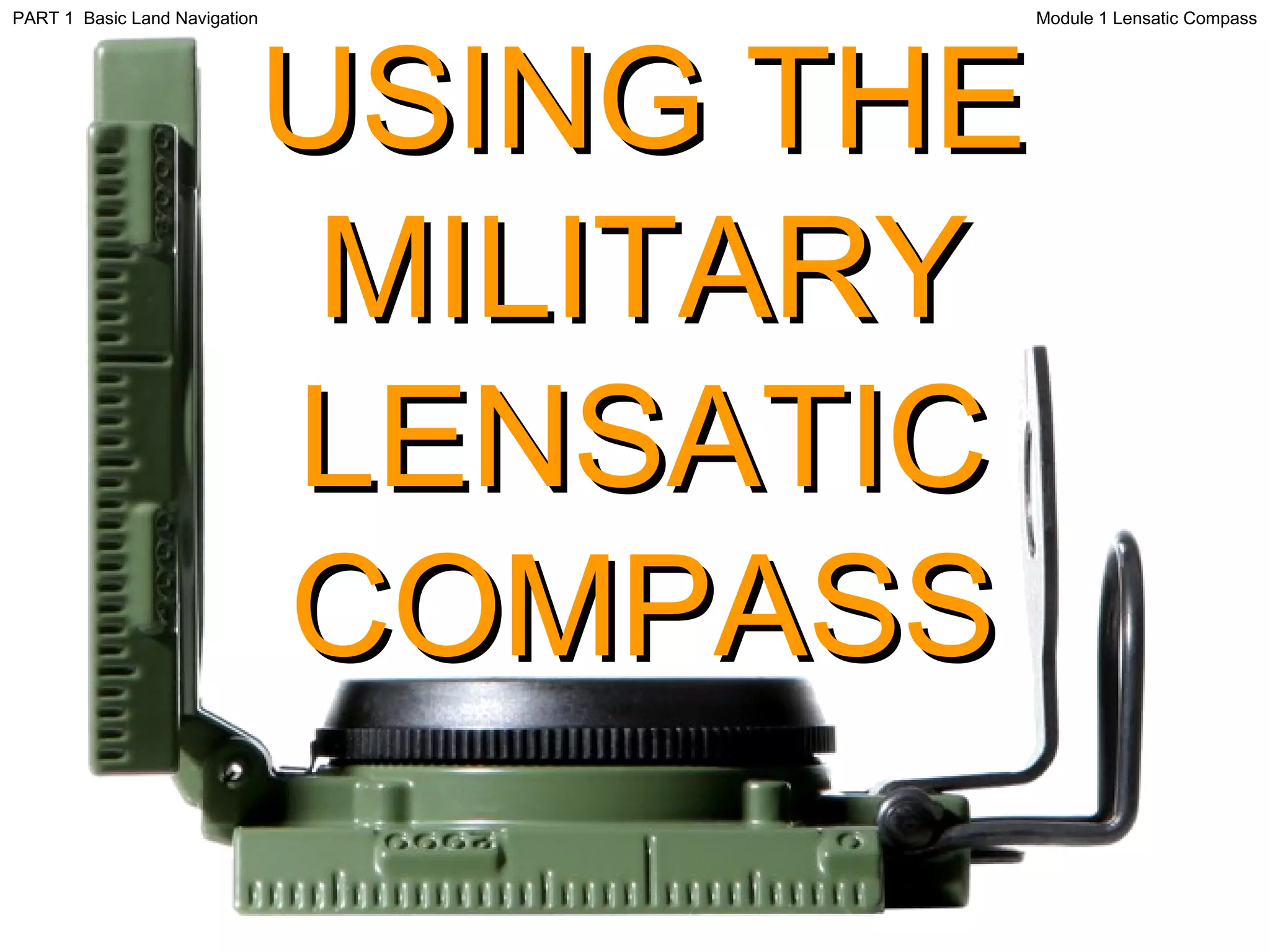
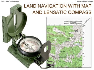
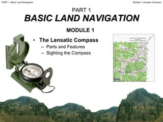
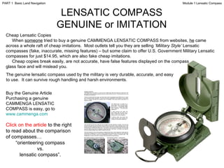
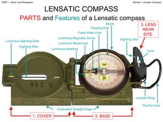
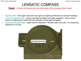
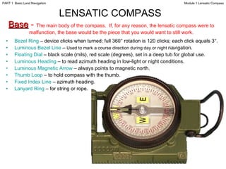
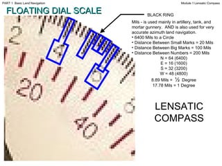
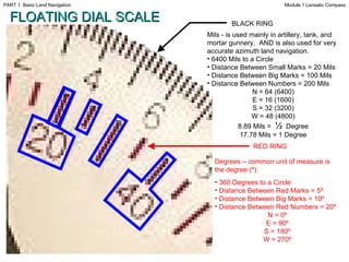
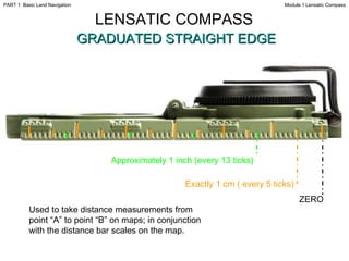
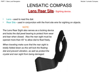
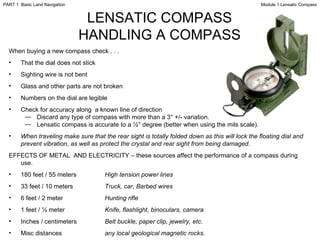
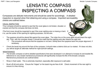
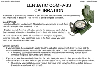
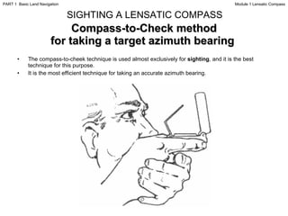
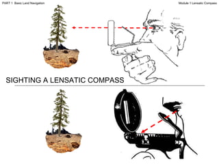
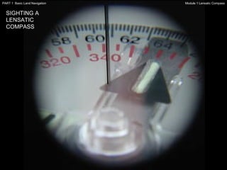
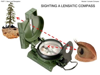
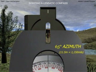
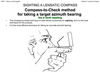
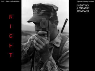
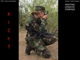
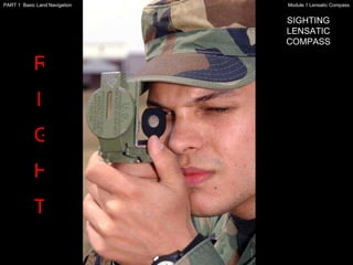
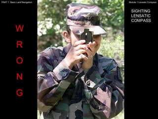
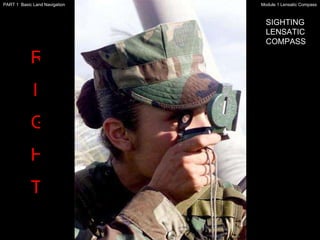
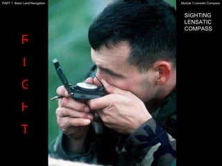
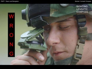
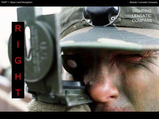
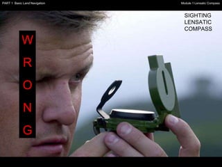
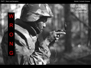
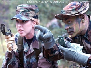
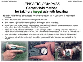
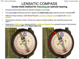
SlideShare a Scribd company logo
1 of 55
USING THE MILITARY LENSATIC COMPASS Module 1 Lensatic Compass PART 1  Basic Land Navigation
This presentation is intended as a quick summary, and not a comprehensive resource.  If you want to learn Land Navigation in detail, either buy a book; or get someone, who has the knowledge and skills, to teach you in person.  WARNING Module 1 Lensatic Compass PART 1  Basic Land Navigation
NOTE Module 1 Lensatic Compass PART 1  Basic Land Navigation To get the ideas across presented on these slides, many figures, pictures, and calculations may not be to scale and may be exaggerated for clarity.
Note: Prior to being issued any training  * equipment, you will be required to sign a “statement of liability” agreeing to pay for anything you damage or lose.  All items will be inspected and inventoried prior to your signature and at the end of the training day too.  If you do not intend to sign this statement, then you may be denied training.   *   You may use your own equipment. Module 1 Lensatic Compass PART 1  Basic Land Navigation
Any Questions? Module 1 Lensatic Compass PART 1  Basic Land Navigation
LAND NAVIGATION PRESENTATION PART 1 Module 1 Lensatic Compass Module 1 Lensatic Compass PART 1  Basic Land Navigation
PRESENTATION . . . and now on with the . . . Module 1 Lensatic Compass PART 1  Basic Land Navigation
LAND NAVIGATION WITH MAP AND   LENSATIC COMPASS Module 1 Lensatic Compass PART 1  Basic Land Navigation
LAND NAVIGATION  ,[object Object],[object Object],[object Object],[object Object],[object Object],[object Object],[object Object],[object Object],[object Object],[object Object],[object Object],[object Object],[object Object],(Where am  I  ?) (How far is it and am  I  there yet ?) (Where do  I  want to go and where am  I  actually going ?) (Do  I  understand the map ?) (What hill or river am  I  looking at ?) (Can  I  mentally visualize the landscape in 3D ?) (Take a long safe route or a short risky route ?) Training and practicing land navigation on foot provides the following everyday navigation (how not to get lost) benefits; Module 1 Lensatic Compass PART 1  Basic Land Navigation
[object Object],[object Object],[object Object],[object Object],[object Object],[object Object],[object Object],[object Object],[object Object],[object Object],[object Object],[object Object],[object Object],[object Object],[object Object],[object Object],[object Object],[object Object],Module 1 Lensatic Compass PART 1  Basic Land Navigation
THESE ARE THE TRAINING MODULES Module 1 Lensatic Compass –  parts and features, and how to sight the compass by two different methods. Module 2 Topo Map Margin –  what map margin data represents, map care, and how to properly fold a map. Module 3 Topo Map Scale –  map sizes and how it affects amount of detail that will be shown. Module 4 Topo Map Symbols –  you must understand them; to read and speak map language to others. Module 5 Terrain Relief –  shows elevation, indicates terrain features and heights of natural features. Module 6 Map Information –  what a protractor is for and how a map provides four kinds of information. Module 7 Sense of Direction –  lateral drift, current bearing, obstacles, back azimuth, deliberate offset. Module 8 Resection –  locate position with map only.  Modified resection is with a map or compass. Module 9 Intersection & Triangulation –  two methods to locate position by compass. Module 10 Map Speaks Compass Language -  there is no need to orient the map to find your position. Module 11 Plotting Position Coordinates –  exact positioning, used to communicate to others with a map. Module 12 Route Measure –  mapping straight-line distance, curvature distance, and slope distance. Module 13 Pace Count –  using ranger pacing beads and  estimating hiking speed. Module 14 Travel Distance Estimation –  estimating by 100 meter rule, rule-of-thumb, and by time. Module 15 Plan to Navigate –  in a group or alone, equipment, safety, responsibilities, route selection. Module 16 Stay on Course –  advance reference points and advance baselines. Module 17 Additional Land Navigation Skills –  estimate daylight, conserve energy, blisters, weather insight.  Module 18 Navigating Different Terrain –  special environments, featureless terrain, visibility, dense foilage. Module 19 Night Navigation –  night adaptation, protecting night vision, navigate with lensatic compass. Module 20 Sustainment –  maintaining skills, training others, setting up a land navigation course. Module 1 Lensatic Compass PART 1  Basic Land Navigation
Any Questions? Module 1 Lensatic Compass PART 1  Basic Land Navigation
PART 1 BASIC LAND NAVIGATION ,[object Object],[object Object],[object Object],[object Object],Module 1 Lensatic Compass PART 1  Basic Land Navigation
The genuine Lensatic compass differs from the type most hikers are familiar with, the traditional "orienteering" compasses.  The Lensatic, a design preferred by military forces for its precision and durability, is designed to take hyper-accurate bearings for land navigation and directing artillery fire! THE LENSATIC COMPASS Module 1 Lensatic Compass PART 1  Basic Land Navigation
LENSATIC COMPASS DESCRIPTION ,[object Object],[object Object],[object Object],[object Object],[object Object],[object Object],[object Object],[object Object],[object Object],[object Object],[object Object],Module 1 Lensatic Compass PART 1  Basic Land Navigation
LENSATIC COMPASS GENUINE or IMITATION Cheap Lensatic Copies When  someone  tried to buy a genuine CAMMENGA LENSATIC COMPASS from websites,  he  came across a whole raft of cheap imitations.  Most outlets tell you they are selling  ‘Military Style’  Lensatic compasses (fake, inaccurate, missing features) – but some claim to offer U.S. Government Military Lensatic compasses for just $14.95, which are also fake cheap imitations. Cheap copies break easily, are not accurate, have false features displayed on the compass glass face and will mislead you. The genuine lensatic compass used by the military is very durable, accurate, and easy to use.  It can survive rough handling and harsh environments. Buy the Genuine Article Purchasing a genuine CAMMENGA LENSATIC COMPASS is easy, go to  www.cammenga.com Click   on the article  to the right to read about the comparison of compasses… “ orienteering compass vs. lensatic compass”. Module 1 Lensatic Compass PART 1  Basic Land Navigation
Thumb Loop Lanyard Ring Sighting Slot Lens Luminous Bezel Line Luminous Magnetic Arrow Fixed Index Line Luminous Heading Luminous Sighting Dots Sighting Wire Graduated Straight Edge Floating Dial Bezel LENSATIC COMPASS   PARTS  and  Features  of a Lensatic compass Module 1 Lensatic Compass PART 1  Basic Land Navigation 1. COVER 2. BASE 3. LENS REAR SITE
[object Object],[object Object],[object Object],LENSATIC COMPASS   Cover   -  Protects the floating dial and other parts of the compass when closed.   Module 1 Lensatic Compass PART 1  Basic Land Navigation
LENSATIC COMPASS   Base  -  The main body of the compass.  If, for any reason, the lensatic compass were to malfunction, the base would be the piece that you would want to still work. ,[object Object],[object Object],[object Object],[object Object],[object Object],[object Object],[object Object],[object Object],Module 1 Lensatic Compass PART 1  Basic Land Navigation
FLOATING DIAL SCALE BLACK RING ,[object Object],[object Object],[object Object],[object Object],[object Object],[object Object],[object Object],[object Object],[object Object],[object Object],[object Object],LENSATIC COMPASS Module 1 Lensatic Compass PART 1  Basic Land Navigation
[object Object],[object Object],[object Object],[object Object],[object Object],[object Object],[object Object],[object Object],[object Object],BLACK RING RED RING FLOATING DIAL SCALE ,[object Object],[object Object],[object Object],[object Object],[object Object],[object Object],[object Object],[object Object],[object Object],[object Object],[object Object],Module 1 Lensatic Compass PART 1  Basic Land Navigation
Any Questions? Module 1 Lensatic Compass PART 1  Basic Land Navigation
Exactly 1 cm ( every 5 ticks) Approximately 1 inch (every 13 ticks) ZERO Used to take distance measurements from point “A” to point “B” on maps; in conjunction with the distance bar scales on the map. LENSATIC COMPASS   GRADUATED STRAIGHT EDGE Module 1 Lensatic Compass PART 1  Basic Land Navigation
[object Object],[object Object],[object Object],[object Object],[object Object],[object Object],[object Object],[object Object],[object Object],[object Object],[object Object],LENSATIC COMPASS   Lens Rear Site  - Sighting device.  Module 1 Lensatic Compass PART 1  Basic Land Navigation
LENSATIC COMPASS HANDLING A COMPASS ,[object Object],[object Object],[object Object],[object Object],[object Object],[object Object],[object Object],[object Object],[object Object],[object Object],[object Object],[object Object],[object Object],[object Object],[object Object],[object Object],[object Object],Module 1 Lensatic Compass PART 1  Basic Land Navigation
LENSATIC COMPASS INSPECTING A COMPASS Compasses are delicate instruments and should be cared for accordingly.  A detailed inspection is required when first obtaining and using a compass.  Important serviceability checks are outlined below: ,[object Object],[object Object],[object Object],[object Object],[object Object],[object Object],[object Object],[object Object],[object Object],[object Object],Module 1 Lensatic Compass PART 1  Basic Land Navigation
LENSATIC COMPASS CALIBRATION A compass in good working condition is very accurate, but it should be checked periodically on a known line of direction.  This process is called compass calibration. ,[object Object],[object Object],[object Object],[object Object],[object Object],[object Object],[object Object],[object Object],[object Object],Module 1 Lensatic Compass PART 1  Basic Land Navigation
HOW TO SIGHT  A  LENSATIC COMPASS Module 1 Lensatic Compass PART 1  Basic Land Navigation
Compass-to-Check method for taking a target azimuth bearing  ,[object Object],[object Object],SIGHTING A LENSATIC COMPASS Module 1 Lensatic Compass PART 1  Basic Land Navigation
SIGHTING A LENSATIC COMPASS Module 1 Lensatic Compass PART 1  Basic Land Navigation
65°  AZIMUTH (11.5m = 1,150mils) SIGHTING A LENSATIC COMPASS Module 1 Lensatic Compass PART 1  Basic Land Navigation
Compass-to-Check method for taking a target azimuth bearing  this is worth repeating ,[object Object],[object Object],SIGHTING A LENSATIC COMPASS Module 1 Lensatic Compass PART 1  Basic Land Navigation
R I G H T SIGHTING LENSATIC COMPASS Module 1 Lensatic Compass PART 1  Basic Land Navigation
W R O N G SIGHTING LENSATIC COMPASS Module 1 Lensatic Compass PART 1  Basic Land Navigation
R I G H T SIGHTING LENSATIC COMPASS Module 1 Lensatic Compass PART 1  Basic Land Navigation
W R O N G SIGHTING LENSATIC COMPASS Module 1 Lensatic Compass PART 1  Basic Land Navigation
R I G H T SIGHTING LENSATIC COMPASS Module 1 Lensatic Compass PART 1  Basic Land Navigation
W R O N G SIGHTING LENSATIC COMPASS Module 1 Lensatic Compass PART 1  Basic Land Navigation
SIGHTING A LENSATIC COMPASS Module 1 Lensatic Compass PART 1  Basic Land Navigation
Any Questions? Module 1 Lensatic Compass PART 1  Basic Land Navigation
Center-Hold method for taking a  target  azimuth bearing  ,[object Object],[object Object],[object Object],[object Object],[object Object],[object Object],[object Object],[object Object],LENSATIC COMPASS Module 1 Lensatic Compass PART 1  Basic Land Navigation
Any Questions? Module 1 Lensatic Compass PART 1  Basic Land Navigation
Center-Hold method for  following  an azimuth bearing  ,[object Object],[object Object],[object Object],[object Object],[object Object],LENSATIC COMPASS STEP 2 STEP 3 Module 1 Lensatic Compass PART 1  Basic Land Navigation
Any Questions? Module 1 Lensatic Compass PART 1  Basic Land Navigation
Note: Prior to being issued any training  * equipment, you will be required to sign a “statement of liability” agreeing to pay for anything you damage or lose.  All items will be inspected and inventoried prior to your signature and at the end of the training day too.  If you do not intend to sign this statement, then you may be denied training.   *   You may use your own equipment. Module 1 Lensatic Compass PART 1  Basic Land Navigation
[object Object],[object Object],[object Object],TESTING Module 1 Lensatic Compass PART 1  Basic Land Navigation
THE END OF LAND NAVIGATION PRESENTATION PART 1 Module 1 Lensatic Compass Module 1 Lensatic Compass PART 1  Basic Land Navigation

More Related Content

What's hot

Compass Navigation for Light Infantry Leaders
Compass Navigation for Light Infantry LeadersCompass Navigation for Light Infantry Leaders
Compass Navigation for Light Infantry LeadersSteven Hoober
 
FCP 6 - Field Navigation - CFSGT Putland - Mar 10
FCP 6 - Field Navigation - CFSGT Putland - Mar 10FCP 6 - Field Navigation - CFSGT Putland - Mar 10
FCP 6 - Field Navigation - CFSGT Putland - Mar 10715 Squadron
 
Military Map: Terrain features - with animations
Military Map: Terrain features - with animations Military Map: Terrain features - with animations
Military Map: Terrain features - with animations AJ Unknown
 
Land Navigation Presentation
Land Navigation PresentationLand Navigation Presentation
Land Navigation PresentationWilliam Perkins
 
How to use a lensatic compass
How to use a lensatic compassHow to use a lensatic compass
How to use a lensatic compasssbeck46
 
Lectura de cartasvak
Lectura de cartasvakLectura de cartasvak
Lectura de cartasvakfreddyvak
 
GPS & its application in mining
GPS & its application in miningGPS & its application in mining
GPS & its application in miningAmit Debnath
 
8.Charts
8.Charts8.Charts
8.ChartsAmenBAL
 
chapter19. Terrestrial and Close-Range Photogrammetry.pdf
chapter19. Terrestrial and Close-Range Photogrammetry.pdfchapter19. Terrestrial and Close-Range Photogrammetry.pdf
chapter19. Terrestrial and Close-Range Photogrammetry.pdfssuser3f7a17
 
03 cameras & their geometry
03 cameras & their geometry03 cameras & their geometry
03 cameras & their geometrySarhat Adam
 
Introduction to surveying (2).pdf
Introduction to surveying (2).pdfIntroduction to surveying (2).pdf
Introduction to surveying (2).pdfBivaYadav3
 
Compass & Bearings
Compass & BearingsCompass & Bearings
Compass & Bearingssmsknight
 
GNSS and Total Station Survey
GNSS and Total Station SurveyGNSS and Total Station Survey
GNSS and Total Station Surveynihal navin
 
Height systems and vertical datums
Height systems and vertical datumsHeight systems and vertical datums
Height systems and vertical datumsAhmad Hasan
 
BASIC CONCEPTS OF PHOTOGRAMMETRY
BASIC CONCEPTS OF PHOTOGRAMMETRYBASIC CONCEPTS OF PHOTOGRAMMETRY
BASIC CONCEPTS OF PHOTOGRAMMETRYNamitha M R
 
Celestial navigation 2014 (pdf)
Celestial navigation 2014 (pdf)Celestial navigation 2014 (pdf)
Celestial navigation 2014 (pdf)Chia-Yi Yen
 

What's hot (20)

Compass Navigation for Light Infantry Leaders
Compass Navigation for Light Infantry LeadersCompass Navigation for Light Infantry Leaders
Compass Navigation for Light Infantry Leaders
 
FCP 6 - Field Navigation - CFSGT Putland - Mar 10
FCP 6 - Field Navigation - CFSGT Putland - Mar 10FCP 6 - Field Navigation - CFSGT Putland - Mar 10
FCP 6 - Field Navigation - CFSGT Putland - Mar 10
 
Military Map: Terrain features - with animations
Military Map: Terrain features - with animations Military Map: Terrain features - with animations
Military Map: Terrain features - with animations
 
Land Navigation Presentation
Land Navigation PresentationLand Navigation Presentation
Land Navigation Presentation
 
How to use a lensatic compass
How to use a lensatic compassHow to use a lensatic compass
How to use a lensatic compass
 
Map Reading
Map ReadingMap Reading
Map Reading
 
Lectura de cartasvak
Lectura de cartasvakLectura de cartasvak
Lectura de cartasvak
 
GPS & its application in mining
GPS & its application in miningGPS & its application in mining
GPS & its application in mining
 
8.Charts
8.Charts8.Charts
8.Charts
 
chapter19. Terrestrial and Close-Range Photogrammetry.pdf
chapter19. Terrestrial and Close-Range Photogrammetry.pdfchapter19. Terrestrial and Close-Range Photogrammetry.pdf
chapter19. Terrestrial and Close-Range Photogrammetry.pdf
 
03 cameras & their geometry
03 cameras & their geometry03 cameras & their geometry
03 cameras & their geometry
 
Introduction to surveying (2).pdf
Introduction to surveying (2).pdfIntroduction to surveying (2).pdf
Introduction to surveying (2).pdf
 
Modern cartography
Modern cartographyModern cartography
Modern cartography
 
Compass & Bearings
Compass & BearingsCompass & Bearings
Compass & Bearings
 
GNSS and Total Station Survey
GNSS and Total Station SurveyGNSS and Total Station Survey
GNSS and Total Station Survey
 
Height systems and vertical datums
Height systems and vertical datumsHeight systems and vertical datums
Height systems and vertical datums
 
BASIC CONCEPTS OF PHOTOGRAMMETRY
BASIC CONCEPTS OF PHOTOGRAMMETRYBASIC CONCEPTS OF PHOTOGRAMMETRY
BASIC CONCEPTS OF PHOTOGRAMMETRY
 
Celestial navigation 2014 (pdf)
Celestial navigation 2014 (pdf)Celestial navigation 2014 (pdf)
Celestial navigation 2014 (pdf)
 
unmanned aerial vehicles
 unmanned aerial vehicles unmanned aerial vehicles
unmanned aerial vehicles
 
Surveying introduction
Surveying introductionSurveying introduction
Surveying introduction
 

Similar to Landnav module 1

Silva navigation 2011
Silva navigation 2011Silva navigation 2011
Silva navigation 2011FerreHogar
 
Livelox as a Training Aid
Livelox as a Training AidLivelox as a Training Aid
Livelox as a Training AidGord Hunter
 
Introduction togps shsm
Introduction togps shsmIntroduction togps shsm
Introduction togps shsmWRDSB
 
Geocaching citb mb presenatation day 2
Geocaching citb mb presenatation day 2Geocaching citb mb presenatation day 2
Geocaching citb mb presenatation day 2Joseph Murphy
 
Uwphoto Week3y Basic Rules
Uwphoto Week3y Basic RulesUwphoto Week3y Basic Rules
Uwphoto Week3y Basic Rulesguestf1965
 

Similar to Landnav module 1 (8)

Silva navigation 2011
Silva navigation 2011Silva navigation 2011
Silva navigation 2011
 
Remote sensing
Remote sensingRemote sensing
Remote sensing
 
Livelox as a Training Aid
Livelox as a Training AidLivelox as a Training Aid
Livelox as a Training Aid
 
IAKM Wayfinding proposal
IAKM Wayfinding proposalIAKM Wayfinding proposal
IAKM Wayfinding proposal
 
Night vfr
Night vfrNight vfr
Night vfr
 
Introduction togps shsm
Introduction togps shsmIntroduction togps shsm
Introduction togps shsm
 
Geocaching citb mb presenatation day 2
Geocaching citb mb presenatation day 2Geocaching citb mb presenatation day 2
Geocaching citb mb presenatation day 2
 
Uwphoto Week3y Basic Rules
Uwphoto Week3y Basic RulesUwphoto Week3y Basic Rules
Uwphoto Week3y Basic Rules
 

Recently uploaded

Paris 2024 Olympic Geographies - an activity
Paris 2024 Olympic Geographies - an activityParis 2024 Olympic Geographies - an activity
Paris 2024 Olympic Geographies - an activityGeoBlogs
 
Crayon Activity Handout For the Crayon A
Crayon Activity Handout For the Crayon ACrayon Activity Handout For the Crayon A
Crayon Activity Handout For the Crayon AUnboundStockton
 
Incoming and Outgoing Shipments in 1 STEP Using Odoo 17
Incoming and Outgoing Shipments in 1 STEP Using Odoo 17Incoming and Outgoing Shipments in 1 STEP Using Odoo 17
Incoming and Outgoing Shipments in 1 STEP Using Odoo 17Celine George
 
Introduction to AI in Higher Education_draft.pptx
Introduction to AI in Higher Education_draft.pptxIntroduction to AI in Higher Education_draft.pptx
Introduction to AI in Higher Education_draft.pptxpboyjonauth
 
Painted Grey Ware.pptx, PGW Culture of India
Painted Grey Ware.pptx, PGW Culture of IndiaPainted Grey Ware.pptx, PGW Culture of India
Painted Grey Ware.pptx, PGW Culture of IndiaVirag Sontakke
 
_Math 4-Q4 Week 5.pptx Steps in Collecting Data
_Math 4-Q4 Week 5.pptx Steps in Collecting Data_Math 4-Q4 Week 5.pptx Steps in Collecting Data
_Math 4-Q4 Week 5.pptx Steps in Collecting DataJhengPantaleon
 
Introduction to ArtificiaI Intelligence in Higher Education
Introduction to ArtificiaI Intelligence in Higher EducationIntroduction to ArtificiaI Intelligence in Higher Education
Introduction to ArtificiaI Intelligence in Higher Educationpboyjonauth
 
Software Engineering Methodologies (overview)
Software Engineering Methodologies (overview)Software Engineering Methodologies (overview)
Software Engineering Methodologies (overview)eniolaolutunde
 
call girls in Kamla Market (DELHI) 🔝 >༒9953330565🔝 genuine Escort Service 🔝✔️✔️
call girls in Kamla Market (DELHI) 🔝 >༒9953330565🔝 genuine Escort Service 🔝✔️✔️call girls in Kamla Market (DELHI) 🔝 >༒9953330565🔝 genuine Escort Service 🔝✔️✔️
call girls in Kamla Market (DELHI) 🔝 >༒9953330565🔝 genuine Escort Service 🔝✔️✔️9953056974 Low Rate Call Girls In Saket, Delhi NCR
 
Solving Puzzles Benefits Everyone (English).pptx
Solving Puzzles Benefits Everyone (English).pptxSolving Puzzles Benefits Everyone (English).pptx
Solving Puzzles Benefits Everyone (English).pptxOH TEIK BIN
 
Pharmacognosy Flower 3. Compositae 2023.pdf
Pharmacognosy Flower 3. Compositae 2023.pdfPharmacognosy Flower 3. Compositae 2023.pdf
Pharmacognosy Flower 3. Compositae 2023.pdfMahmoud M. Sallam
 
ENGLISH5 QUARTER4 MODULE1 WEEK1-3 How Visual and Multimedia Elements.pptx
ENGLISH5 QUARTER4 MODULE1 WEEK1-3 How Visual and Multimedia Elements.pptxENGLISH5 QUARTER4 MODULE1 WEEK1-3 How Visual and Multimedia Elements.pptx
ENGLISH5 QUARTER4 MODULE1 WEEK1-3 How Visual and Multimedia Elements.pptxAnaBeatriceAblay2
 
The Most Excellent Way | 1 Corinthians 13
The Most Excellent Way | 1 Corinthians 13The Most Excellent Way | 1 Corinthians 13
The Most Excellent Way | 1 Corinthians 13Steve Thomason
 
How to Configure Email Server in Odoo 17
How to Configure Email Server in Odoo 17How to Configure Email Server in Odoo 17
How to Configure Email Server in Odoo 17Celine George
 
EPANDING THE CONTENT OF AN OUTLINE using notes.pptx
EPANDING THE CONTENT OF AN OUTLINE using notes.pptxEPANDING THE CONTENT OF AN OUTLINE using notes.pptx
EPANDING THE CONTENT OF AN OUTLINE using notes.pptxRaymartEstabillo3
 
How to Make a Pirate ship Primary Education.pptx
How to Make a Pirate ship Primary Education.pptxHow to Make a Pirate ship Primary Education.pptx
How to Make a Pirate ship Primary Education.pptxmanuelaromero2013
 
Class 11 Legal Studies Ch-1 Concept of State .pdf
Class 11 Legal Studies Ch-1 Concept of State .pdfClass 11 Legal Studies Ch-1 Concept of State .pdf
Class 11 Legal Studies Ch-1 Concept of State .pdfakmcokerachita
 
BASLIQ CURRENT LOOKBOOK LOOKBOOK(1) (1).pdf
BASLIQ CURRENT LOOKBOOK  LOOKBOOK(1) (1).pdfBASLIQ CURRENT LOOKBOOK  LOOKBOOK(1) (1).pdf
BASLIQ CURRENT LOOKBOOK LOOKBOOK(1) (1).pdfSoniaTolstoy
 

Recently uploaded (20)

Paris 2024 Olympic Geographies - an activity
Paris 2024 Olympic Geographies - an activityParis 2024 Olympic Geographies - an activity
Paris 2024 Olympic Geographies - an activity
 
Crayon Activity Handout For the Crayon A
Crayon Activity Handout For the Crayon ACrayon Activity Handout For the Crayon A
Crayon Activity Handout For the Crayon A
 
Incoming and Outgoing Shipments in 1 STEP Using Odoo 17
Incoming and Outgoing Shipments in 1 STEP Using Odoo 17Incoming and Outgoing Shipments in 1 STEP Using Odoo 17
Incoming and Outgoing Shipments in 1 STEP Using Odoo 17
 
Introduction to AI in Higher Education_draft.pptx
Introduction to AI in Higher Education_draft.pptxIntroduction to AI in Higher Education_draft.pptx
Introduction to AI in Higher Education_draft.pptx
 
9953330565 Low Rate Call Girls In Rohini Delhi NCR
9953330565 Low Rate Call Girls In Rohini  Delhi NCR9953330565 Low Rate Call Girls In Rohini  Delhi NCR
9953330565 Low Rate Call Girls In Rohini Delhi NCR
 
Painted Grey Ware.pptx, PGW Culture of India
Painted Grey Ware.pptx, PGW Culture of IndiaPainted Grey Ware.pptx, PGW Culture of India
Painted Grey Ware.pptx, PGW Culture of India
 
_Math 4-Q4 Week 5.pptx Steps in Collecting Data
_Math 4-Q4 Week 5.pptx Steps in Collecting Data_Math 4-Q4 Week 5.pptx Steps in Collecting Data
_Math 4-Q4 Week 5.pptx Steps in Collecting Data
 
Introduction to ArtificiaI Intelligence in Higher Education
Introduction to ArtificiaI Intelligence in Higher EducationIntroduction to ArtificiaI Intelligence in Higher Education
Introduction to ArtificiaI Intelligence in Higher Education
 
Software Engineering Methodologies (overview)
Software Engineering Methodologies (overview)Software Engineering Methodologies (overview)
Software Engineering Methodologies (overview)
 
call girls in Kamla Market (DELHI) 🔝 >༒9953330565🔝 genuine Escort Service 🔝✔️✔️
call girls in Kamla Market (DELHI) 🔝 >༒9953330565🔝 genuine Escort Service 🔝✔️✔️call girls in Kamla Market (DELHI) 🔝 >༒9953330565🔝 genuine Escort Service 🔝✔️✔️
call girls in Kamla Market (DELHI) 🔝 >༒9953330565🔝 genuine Escort Service 🔝✔️✔️
 
Solving Puzzles Benefits Everyone (English).pptx
Solving Puzzles Benefits Everyone (English).pptxSolving Puzzles Benefits Everyone (English).pptx
Solving Puzzles Benefits Everyone (English).pptx
 
Pharmacognosy Flower 3. Compositae 2023.pdf
Pharmacognosy Flower 3. Compositae 2023.pdfPharmacognosy Flower 3. Compositae 2023.pdf
Pharmacognosy Flower 3. Compositae 2023.pdf
 
ENGLISH5 QUARTER4 MODULE1 WEEK1-3 How Visual and Multimedia Elements.pptx
ENGLISH5 QUARTER4 MODULE1 WEEK1-3 How Visual and Multimedia Elements.pptxENGLISH5 QUARTER4 MODULE1 WEEK1-3 How Visual and Multimedia Elements.pptx
ENGLISH5 QUARTER4 MODULE1 WEEK1-3 How Visual and Multimedia Elements.pptx
 
The Most Excellent Way | 1 Corinthians 13
The Most Excellent Way | 1 Corinthians 13The Most Excellent Way | 1 Corinthians 13
The Most Excellent Way | 1 Corinthians 13
 
How to Configure Email Server in Odoo 17
How to Configure Email Server in Odoo 17How to Configure Email Server in Odoo 17
How to Configure Email Server in Odoo 17
 
EPANDING THE CONTENT OF AN OUTLINE using notes.pptx
EPANDING THE CONTENT OF AN OUTLINE using notes.pptxEPANDING THE CONTENT OF AN OUTLINE using notes.pptx
EPANDING THE CONTENT OF AN OUTLINE using notes.pptx
 
How to Make a Pirate ship Primary Education.pptx
How to Make a Pirate ship Primary Education.pptxHow to Make a Pirate ship Primary Education.pptx
How to Make a Pirate ship Primary Education.pptx
 
Class 11 Legal Studies Ch-1 Concept of State .pdf
Class 11 Legal Studies Ch-1 Concept of State .pdfClass 11 Legal Studies Ch-1 Concept of State .pdf
Class 11 Legal Studies Ch-1 Concept of State .pdf
 
TataKelola dan KamSiber Kecerdasan Buatan v022.pdf
TataKelola dan KamSiber Kecerdasan Buatan v022.pdfTataKelola dan KamSiber Kecerdasan Buatan v022.pdf
TataKelola dan KamSiber Kecerdasan Buatan v022.pdf
 
BASLIQ CURRENT LOOKBOOK LOOKBOOK(1) (1).pdf
BASLIQ CURRENT LOOKBOOK  LOOKBOOK(1) (1).pdfBASLIQ CURRENT LOOKBOOK  LOOKBOOK(1) (1).pdf
BASLIQ CURRENT LOOKBOOK LOOKBOOK(1) (1).pdf
 

Landnav module 1

  • 1. USING THE MILITARY LENSATIC COMPASS Module 1 Lensatic Compass PART 1 Basic Land Navigation
  • 2. This presentation is intended as a quick summary, and not a comprehensive resource. If you want to learn Land Navigation in detail, either buy a book; or get someone, who has the knowledge and skills, to teach you in person. WARNING Module 1 Lensatic Compass PART 1 Basic Land Navigation
  • 3. NOTE Module 1 Lensatic Compass PART 1 Basic Land Navigation To get the ideas across presented on these slides, many figures, pictures, and calculations may not be to scale and may be exaggerated for clarity.
  • 4. Note: Prior to being issued any training * equipment, you will be required to sign a “statement of liability” agreeing to pay for anything you damage or lose. All items will be inspected and inventoried prior to your signature and at the end of the training day too. If you do not intend to sign this statement, then you may be denied training. * You may use your own equipment. Module 1 Lensatic Compass PART 1 Basic Land Navigation
  • 5. Any Questions? Module 1 Lensatic Compass PART 1 Basic Land Navigation
  • 6. LAND NAVIGATION PRESENTATION PART 1 Module 1 Lensatic Compass Module 1 Lensatic Compass PART 1 Basic Land Navigation
  • 7. PRESENTATION . . . and now on with the . . . Module 1 Lensatic Compass PART 1 Basic Land Navigation
  • 8. LAND NAVIGATION WITH MAP AND LENSATIC COMPASS Module 1 Lensatic Compass PART 1 Basic Land Navigation
  • 9.
  • 10.
  • 11. THESE ARE THE TRAINING MODULES Module 1 Lensatic Compass – parts and features, and how to sight the compass by two different methods. Module 2 Topo Map Margin – what map margin data represents, map care, and how to properly fold a map. Module 3 Topo Map Scale – map sizes and how it affects amount of detail that will be shown. Module 4 Topo Map Symbols – you must understand them; to read and speak map language to others. Module 5 Terrain Relief – shows elevation, indicates terrain features and heights of natural features. Module 6 Map Information – what a protractor is for and how a map provides four kinds of information. Module 7 Sense of Direction – lateral drift, current bearing, obstacles, back azimuth, deliberate offset. Module 8 Resection – locate position with map only. Modified resection is with a map or compass. Module 9 Intersection & Triangulation – two methods to locate position by compass. Module 10 Map Speaks Compass Language - there is no need to orient the map to find your position. Module 11 Plotting Position Coordinates – exact positioning, used to communicate to others with a map. Module 12 Route Measure – mapping straight-line distance, curvature distance, and slope distance. Module 13 Pace Count – using ranger pacing beads and estimating hiking speed. Module 14 Travel Distance Estimation – estimating by 100 meter rule, rule-of-thumb, and by time. Module 15 Plan to Navigate – in a group or alone, equipment, safety, responsibilities, route selection. Module 16 Stay on Course – advance reference points and advance baselines. Module 17 Additional Land Navigation Skills – estimate daylight, conserve energy, blisters, weather insight. Module 18 Navigating Different Terrain – special environments, featureless terrain, visibility, dense foilage. Module 19 Night Navigation – night adaptation, protecting night vision, navigate with lensatic compass. Module 20 Sustainment – maintaining skills, training others, setting up a land navigation course. Module 1 Lensatic Compass PART 1 Basic Land Navigation
  • 12. Any Questions? Module 1 Lensatic Compass PART 1 Basic Land Navigation
  • 13.
  • 14. The genuine Lensatic compass differs from the type most hikers are familiar with, the traditional "orienteering" compasses. The Lensatic, a design preferred by military forces for its precision and durability, is designed to take hyper-accurate bearings for land navigation and directing artillery fire! THE LENSATIC COMPASS Module 1 Lensatic Compass PART 1 Basic Land Navigation
  • 15.
  • 16. LENSATIC COMPASS GENUINE or IMITATION Cheap Lensatic Copies When someone tried to buy a genuine CAMMENGA LENSATIC COMPASS from websites, he came across a whole raft of cheap imitations. Most outlets tell you they are selling ‘Military Style’ Lensatic compasses (fake, inaccurate, missing features) – but some claim to offer U.S. Government Military Lensatic compasses for just $14.95, which are also fake cheap imitations. Cheap copies break easily, are not accurate, have false features displayed on the compass glass face and will mislead you. The genuine lensatic compass used by the military is very durable, accurate, and easy to use. It can survive rough handling and harsh environments. Buy the Genuine Article Purchasing a genuine CAMMENGA LENSATIC COMPASS is easy, go to www.cammenga.com Click on the article to the right to read about the comparison of compasses… “ orienteering compass vs. lensatic compass”. Module 1 Lensatic Compass PART 1 Basic Land Navigation
  • 17. Thumb Loop Lanyard Ring Sighting Slot Lens Luminous Bezel Line Luminous Magnetic Arrow Fixed Index Line Luminous Heading Luminous Sighting Dots Sighting Wire Graduated Straight Edge Floating Dial Bezel LENSATIC COMPASS PARTS and Features of a Lensatic compass Module 1 Lensatic Compass PART 1 Basic Land Navigation 1. COVER 2. BASE 3. LENS REAR SITE
  • 18.
  • 19.
  • 20.
  • 21.
  • 22. Any Questions? Module 1 Lensatic Compass PART 1 Basic Land Navigation
  • 23. Exactly 1 cm ( every 5 ticks) Approximately 1 inch (every 13 ticks) ZERO Used to take distance measurements from point “A” to point “B” on maps; in conjunction with the distance bar scales on the map. LENSATIC COMPASS GRADUATED STRAIGHT EDGE Module 1 Lensatic Compass PART 1 Basic Land Navigation
  • 24.
  • 25.
  • 26.
  • 27.
  • 28. HOW TO SIGHT A LENSATIC COMPASS Module 1 Lensatic Compass PART 1 Basic Land Navigation
  • 29.
  • 30. SIGHTING A LENSATIC COMPASS Module 1 Lensatic Compass PART 1 Basic Land Navigation
  • 31. SIGHTING A LENSATIC COMPASS Module 1 Lensatic Compass PART 1 Basic Land Navigation
  • 32. SIGHTING A LENSATIC COMPASS Module 1 Lensatic Compass PART 1 Basic Land Navigation
  • 33. SIGHTING A LENSATIC COMPASS Module 1 Lensatic Compass PART 1 Basic Land Navigation
  • 34. 65° AZIMUTH (11.5m = 1,150mils) SIGHTING A LENSATIC COMPASS Module 1 Lensatic Compass PART 1 Basic Land Navigation
  • 35.
  • 36. R I G H T SIGHTING LENSATIC COMPASS Module 1 Lensatic Compass PART 1 Basic Land Navigation
  • 37. R I G H T SIGHTING LENSATIC COMPASS Module 1 Lensatic Compass PART 1 Basic Land Navigation
  • 38. R I G H T SIGHTING LENSATIC COMPASS Module 1 Lensatic Compass PART 1 Basic Land Navigation
  • 39. W R O N G SIGHTING LENSATIC COMPASS Module 1 Lensatic Compass PART 1 Basic Land Navigation
  • 40. R I G H T SIGHTING LENSATIC COMPASS Module 1 Lensatic Compass PART 1 Basic Land Navigation
  • 41. R I G H T SIGHTING LENSATIC COMPASS Module 1 Lensatic Compass PART 1 Basic Land Navigation
  • 42. R I G H T SIGHTING LENSATIC COMPASS Module 1 Lensatic Compass PART 1 Basic Land Navigation
  • 43. W R O N G SIGHTING LENSATIC COMPASS Module 1 Lensatic Compass PART 1 Basic Land Navigation
  • 44. R I G H T SIGHTING LENSATIC COMPASS Module 1 Lensatic Compass PART 1 Basic Land Navigation
  • 45. W R O N G SIGHTING LENSATIC COMPASS Module 1 Lensatic Compass PART 1 Basic Land Navigation
  • 46. W R O N G SIGHTING LENSATIC COMPASS Module 1 Lensatic Compass PART 1 Basic Land Navigation
  • 47. SIGHTING A LENSATIC COMPASS Module 1 Lensatic Compass PART 1 Basic Land Navigation
  • 48. Any Questions? Module 1 Lensatic Compass PART 1 Basic Land Navigation
  • 49.
  • 50. Any Questions? Module 1 Lensatic Compass PART 1 Basic Land Navigation
  • 51.
  • 52. Any Questions? Module 1 Lensatic Compass PART 1 Basic Land Navigation
  • 53. Note: Prior to being issued any training * equipment, you will be required to sign a “statement of liability” agreeing to pay for anything you damage or lose. All items will be inspected and inventoried prior to your signature and at the end of the training day too. If you do not intend to sign this statement, then you may be denied training. * You may use your own equipment. Module 1 Lensatic Compass PART 1 Basic Land Navigation
  • 54.
  • 55. THE END OF LAND NAVIGATION PRESENTATION PART 1 Module 1 Lensatic Compass Module 1 Lensatic Compass PART 1 Basic Land Navigation