Downloaded 11 times
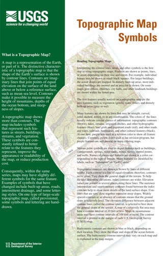


A topographic map uses contour lines to represent the shape and elevation of land features. It also includes symbols representing both natural and man-made features like vegetation, buildings, and roads. Contour lines connect points of equal elevation, allowing the height of mountains, depths of oceans, and steepness of slopes to be measured. A topographic map provides essential information about the landscape and terrain of a mapped area.


![Trail designprinciples[1]](https://cdn.slidesharecdn.com/ss_thumbnails/traildesignprinciples1-110610172403-phpapp02-thumbnail.jpg?width=640&height=640&fit=bounds)


