Download to read offline

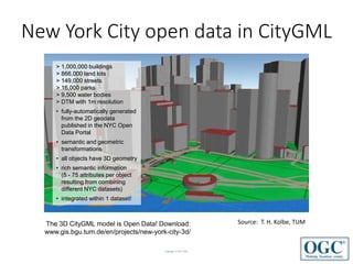


The document outlines the role of the Open Geospatial Consortium (OGC) in developing location standards and facilitating the integration of various datasets, particularly highlighting examples from New York City and Seoul. It emphasizes OGC's commitment to harmonizing standards to address evolving technologies and market needs while promoting collaboration and innovation. The OGC encourages participation and communication within its international membership to enhance the effectiveness of its standards.


![5G Explained! A High Level Overview [Introduction]](https://cdn.slidesharecdn.com/ss_thumbnails/5gexplainedahighleveloverview-260119165306-cc137a3e-thumbnail.jpg?width=640&height=640&fit=bounds)


