1. Karst systems relationships and their influence on transport of potential leachate contamination at Mole Creek,
Tasmania, Australia.
Sarah McNab
GHD Pty Ltd, 2 Salamanca Square, Hobart, TAS 7000, AUS
UNESCO World Heritage listed Marakoopa Cave, Mole Creek Karst
National Park, Tasmania, Australia. The cave’s name comes from the
Aboriginal word meaning ‘handsome’. Photograph by Sarah McNab.
The Mole Creek Refuse Disposal Site (RDS) is an abandoned municipal landfill that was in use from the late
1960s until 1993. The RDS was sited within a complex of sinkholes (see above), without lining or a leachate
collection system. These sinkholes are part of the Mole Creek Karst system, and have long been thought to
drain into the aquifer that feeds Sassafras Creek, thus contributing to an important untreated local water
supply (Brown and DeVries, 1958; Jennings, 1967, 1971; Kiernan, 1992).
A hydrogeological study was designed to identify the karst catchments potentially being influenced by the
landfill, and determine whether contamination attributable to the Mole Creek RDS is affecting the quality of
water supplies within Sassafras Creek. This was achieved through:
1. a water tracing experiment to demonstrate the hypothesised groundwater flow path beneath the
landfill;
2. a hydrogeochemical investigation to detect contamination of the water supply, and to constrain the
location of any contaminant source(s); and
3. a geophysical electrical resistivity survey to model the subsurface structure of landfill pits and their
likely drainage paths.
Introduction
Active face of the largest pit at the Mole Creek Refuse Disposal
Site, with fill material spilling into a well-developed sinkhole,
from Kiernan (1989, p. 76). This site now forms part of the
Great Western Tiers Conservation Area.
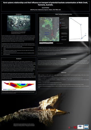
The drainage connection between the Mayberry and Sassafras Basins was proved through hydrogeochemical sampling of key points within both catchments, as outlined in the left image
above. The above right image shows a schematic representation of sampled and laboratory analysed iron concentrations. Iron was detected in Marakoopa Creek, though the concentration
was below the limit of reporting in Sassafras Creek upstream of the hypothesised Mayberry Basin drainage point. Concentrations downstream of the drainage point are similar to those at
the resurgence, albeit slightly diluted by the influence of upstream Sassafras Creek.
Zinc concentrations in Marakoopa Creek within the WHA were identified above environmental trigger values for protected aquatic ecosystems, though the source of this zinc is still
unknown due to a lack of knowledge regarding local karst systems.
Water Tracing & Hydrogeochemistry
47
173
<20
193
169
N
0 1 2 3 4 km
Sample Location
Landfill Location
Known hydrologic connection,
arrow defines flow direction
Hypothesised subsurface
hydrologic connection, arrow
defines likely flow direction
Aerial photo from Google Earth 2011
SC01
SC02
BS01
MC01
MC02
WHA
Mayberry Basin
Sassafras Basin
Sassafras Creek Approximate location of
surface drainage divide
Approximate boundary of
WHA
The figure below shows a true depth section of pit LFW-1 and its software-calculated effects on the
geoelectric structure of the subsurface. Geophysical modelling of the landfill indicates the presence of a pipe-
like drainage structure beneath pit LFW-1, which confirms that these structures are indeed sinkholes and are
hydrologically linked to the aquifer. Drainage the pit appears to be concentrated into a subsurface pipe
bounded by bedrock that continues to depth. If such drainage features exist below most or all of the landfill
pits within sinkholes, it can be inferred that stormwater infiltrates through landfill materials, flushing any
leachate into the aquifer and transmitting it into the Sassafras Creek water supply. Sinkhole drainage at the
Mole Creek RDS may thus represent a significant point-source input for contamination of the aquifer.
Drainage from the landfill pits may facilitate further limestone dissolution at depth, especially given the
generally acidic nature of landfill leachate (Birks and Eyles, 1997). Such contamination may lead to the
possibility of continued karstification of the aquifer and further solutional sinkhole collapse. Although vadose
zone conduits and caverns were not detected through geophysical investigations, the possibility remains that
such features may exist at depth.
Geophysics
LFW-1
LFW-3
Resistivity imaging profile of pits LFW-3 and LFW-1, the approximate boundaries of which are outlined in black. The model shows an area of
comparatively low resistivity beneath pit LFW-1, suggesting that there may be a drainage pathway that facilitates transport of accumulated
leachate from the landfill into the underlying karstic aquifer.
Combining several methods, this study characterised the forms and processes of the localised karst system and contributed to the overall understanding of the
systems relationships of the protected Mole Creek Karst. It also served to highlight the environmental legacy problems inherited by our generation, which are largely
due to a lack of understanding of karst systems relationships in the past. Despite being of international significance, knowledge of the processes affecting the Mole
Creek Karst remains incomplete and poses an ongoing challenge for environmental authorities.
Conclusions
BIRKS, J. & EYLES, C. H. 1997. Leachate From Landfills Along the Niagra Escarpment. In: EYLES, N. (ed.) Environmental Geology of Urban Areas. St. John's,
Newfoundland: Geological Association of Canada.
BROWN, F. R. & DEVRIES, M. H. 1958. The subterranean hydrology of the Mole Creek area. Bulletin of the Tasmanian Caverneering Club, 1, 9-15.
JENNINGS, J. N. 1967. Some Karst Areas of Australia. In: JENNINGS, J. N. & MABBUTT, J. A. (eds.) Landform Studies from Australia and New Guinea. Canberra:
Australian National University Press.
JENNINGS, J. N. 1971. Karst, Canberra, Australian National University Press.
KIERNAN, K. 1989. Karst, caves and management at Mole Creek, Tasmania. Department of Parks, Wildlife and Heritage Occasional Paper 22. Hobart.
KIERNAN, K. 1992. Karst Hydrogeology in Tasmania. In: BACH, W., HERMAN, J. S. & PALOC, H. (eds.) Hydrogeology of Selected Karst Regions. Hannover: Verlag Heinz
Heise.
References