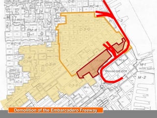
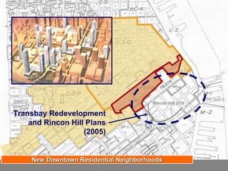
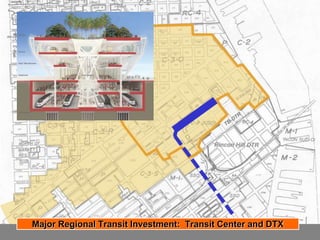
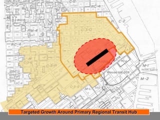
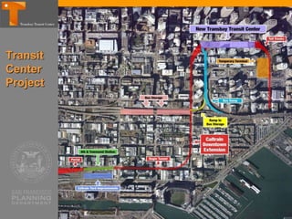
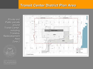
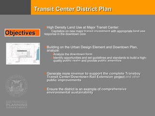
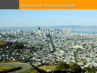
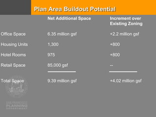
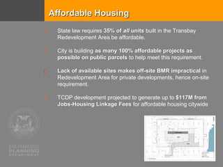
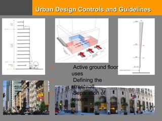
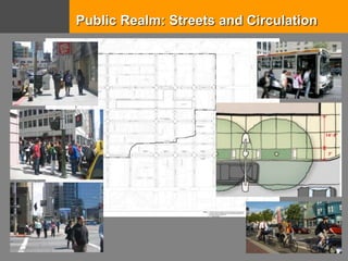
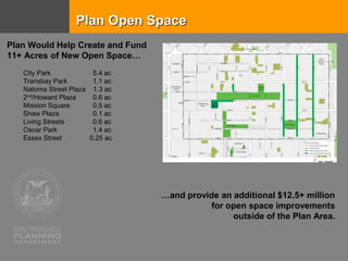
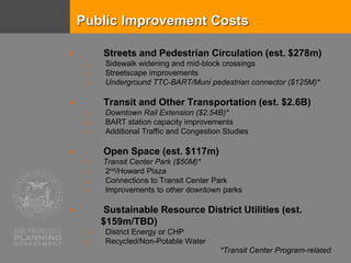
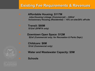
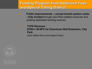
San Francisco Planning, in partnership
with the Transbay Joint Powers
Authority and the Office of Community
Investment and Infrastructure
TRANSIT CENTER
DISTRICT PLAN
Sustainable Urban Systems Symposium
Stanford University June 2016
The only constant
is change.
SAN FRANCISCO 1915 - 1986
1915
1958
1972
1986
Image courtesy of Stewart Bloom (©1990)
The New Heart of Downtown
Downtown Plan 1985: Compact, Walkable, Transit-Oriented
Downtown Plan: Extending the Office District South of Market
Highest Allowed
Heights prior to
plan adoption
(550’)
Development
Transfer
District
Downtown Plan: Extending the Office District South of Market
Transbay Terminal
Demolition of the Embarcadero Freeway
Transbay Redevelopment
and Rincon Hill Plans
(2005)
New Downtown Residential Neighborhoods
Major Regional Transit Investment: Transit Center and DTX
Targeted Growth Around Primary Regional Transit Hub
Transit
Center
Project
Transit Center District Plan Area
Private and
Public parcels
around
Transit Center,
including
Transbay
Redevelopment
Area
Zone 2
High Density Land Use at Major Transit Center:
Capitalize on new major transit investment with appropriate land use
response in the downtown core
Building on the Urban Design Element and Downtown Plan,
analyze:
Analyze the downtown form
Identify opportunities and set guidelines and standards to build a high-
quality public realm and provide public amenities
Generate more revenue to support the complete Transbay
Transit Center/Downtown Rail Extension project and other
public improvements
Ensure the district is an example of comprehensive
environmental sustainability
Objectives
Transit Center District Plan
Dolores Park
nceptual Illustration Only
Urban Form: Previous Heights
Dolores Park
nceptual Illustration Only
Urban Form: Approved Heights
City Form | Emphasizing the Transit Core
Plan Area Buildout Potential
Net Additional Space Increment over
Existing Zoning
Office Space 6.35 million gsf +2.2 million gsf
Housing Units 1,300 +800
Hotel Rooms 975 +800
Retail Space 85,000 gsf --
Total Space 9.39 million gsf +4.02 million gsf
Affordable Housing
 State law requires 35% of all units built in the Transbay
Redevelopment Area be affordable.
 City is building as many 100% affordable projects as
possible on public parcels to help meet this requirement.
 Lack of available sites makes off-site BMR impractical in
Redevelopment Area for private developments, hence on-site
requirement.
 TCDP development projected to generate up to $117M from
Jobs-Housing Linkage Fees for affordable housing citywide
Urban Design Controls and Guidelines
 Active ground floor
uses
 Defining the
streetwall
 Separation of
towers
Public Realm: Streets and Circulation
Plan Open Space
City Park 5.4 ac
Transbay Park 1.1 ac
Natoma Street Plaza 1.3 ac
2nd/Howard Plaza 0.6 ac
Mission Square 0.5 ac
Shaw Plaza 0.1 ac
Living Streets 0.6 ac
Oscar Park 1.4 ac
Essex Street 0.25 ac
Plan Would Help Create and Fund
11+ Acres of New Open Space…
…and provide an additional $12.5+ million
for open space improvements
outside of the Plan Area.
Historic Resources
Public Improvement Costs
 Streets and Pedestrian Circulation (est. $278m)
o Sidewalk widening and mid-block crossings
o Streetscape improvements
o Underground TTC-BART/Muni pedestrian connector ($125M)*
 Transit and Other Transportation (est. $2.6B)
o Downtown Rail Extension ($2.54B)*
o BART station capacity improvements
o Additional Traffic and Congestion Studies
 Open Space (est. $117m)
o Transit Center Park ($50M)*
o 2nd/Howard Plaza
o Connections to Transit Center Park
o Improvements to other downtown parks
 Sustainable Resource District Utilities (est.
$159m/TBD)
o District Energy or CHP
o Recycled/Non-Potable Water
*Transit Center Program-related
Existing Fee Requirements & Revenues
 Affordable Housing: $117M
o Jobs-Housing Linkage (Commercial) -- $20/sf
o Inclusionary Housing (Residential) – 15% on-site/20% off-site
 Transit: $60M
o $12/sf (SFMTA only)
 Downtown Open Space: $12M
o $2/sf (Commercial only; for Recreation & Parks Dept.)
 Childcare: $6M
o $1/sf (Commercial only)
 Water and Wastewater Capacity: $5M
 Schools
Funding Program from Additional Fees
and Special Taxing District
 Public Improvements -- except transit system costs-
- fully funded through new Plan-related revenues and
existing dedicated funding sources
 TJPA Revenue :
$700+/- M NPV for Downtown Rail Extension, City
Park
(from Mello-Roos and Impact Fees)
www.sfplanning.org

John Rahaim - Transit Center District Plan

  • 1.
    San Francisco Planning,in partnership with the Transbay Joint Powers Authority and the Office of Community Investment and Infrastructure TRANSIT CENTER DISTRICT PLAN Sustainable Urban Systems Symposium Stanford University June 2016
  • 2.
    The only constant ischange. SAN FRANCISCO 1915 - 1986 1915 1958 1972 1986 Image courtesy of Stewart Bloom (©1990)
  • 3.
    The New Heartof Downtown
  • 5.
    Downtown Plan 1985:Compact, Walkable, Transit-Oriented
  • 6.
    Downtown Plan: Extendingthe Office District South of Market
  • 7.
    Highest Allowed Heights priorto plan adoption (550’) Development Transfer District Downtown Plan: Extending the Office District South of Market Transbay Terminal
  • 8.
    Demolition of theEmbarcadero Freeway
  • 9.
    Transbay Redevelopment and RinconHill Plans (2005) New Downtown Residential Neighborhoods
  • 10.
    Major Regional TransitInvestment: Transit Center and DTX
  • 11.
    Targeted Growth AroundPrimary Regional Transit Hub
  • 12.
  • 15.
    Transit Center DistrictPlan Area Private and Public parcels around Transit Center, including Transbay Redevelopment Area Zone 2
  • 16.
    High Density LandUse at Major Transit Center: Capitalize on new major transit investment with appropriate land use response in the downtown core Building on the Urban Design Element and Downtown Plan, analyze: Analyze the downtown form Identify opportunities and set guidelines and standards to build a high- quality public realm and provide public amenities Generate more revenue to support the complete Transbay Transit Center/Downtown Rail Extension project and other public improvements Ensure the district is an example of comprehensive environmental sustainability Objectives Transit Center District Plan
  • 18.
    Dolores Park nceptual IllustrationOnly Urban Form: Previous Heights
  • 19.
    Dolores Park nceptual IllustrationOnly Urban Form: Approved Heights
  • 24.
    City Form |Emphasizing the Transit Core
  • 25.
    Plan Area BuildoutPotential Net Additional Space Increment over Existing Zoning Office Space 6.35 million gsf +2.2 million gsf Housing Units 1,300 +800 Hotel Rooms 975 +800 Retail Space 85,000 gsf -- Total Space 9.39 million gsf +4.02 million gsf
  • 26.
    Affordable Housing  Statelaw requires 35% of all units built in the Transbay Redevelopment Area be affordable.  City is building as many 100% affordable projects as possible on public parcels to help meet this requirement.  Lack of available sites makes off-site BMR impractical in Redevelopment Area for private developments, hence on-site requirement.  TCDP development projected to generate up to $117M from Jobs-Housing Linkage Fees for affordable housing citywide
  • 27.
    Urban Design Controlsand Guidelines  Active ground floor uses  Defining the streetwall  Separation of towers
  • 28.
    Public Realm: Streetsand Circulation
  • 29.
    Plan Open Space CityPark 5.4 ac Transbay Park 1.1 ac Natoma Street Plaza 1.3 ac 2nd/Howard Plaza 0.6 ac Mission Square 0.5 ac Shaw Plaza 0.1 ac Living Streets 0.6 ac Oscar Park 1.4 ac Essex Street 0.25 ac Plan Would Help Create and Fund 11+ Acres of New Open Space… …and provide an additional $12.5+ million for open space improvements outside of the Plan Area.
  • 30.
  • 31.
    Public Improvement Costs Streets and Pedestrian Circulation (est. $278m) o Sidewalk widening and mid-block crossings o Streetscape improvements o Underground TTC-BART/Muni pedestrian connector ($125M)*  Transit and Other Transportation (est. $2.6B) o Downtown Rail Extension ($2.54B)* o BART station capacity improvements o Additional Traffic and Congestion Studies  Open Space (est. $117m) o Transit Center Park ($50M)* o 2nd/Howard Plaza o Connections to Transit Center Park o Improvements to other downtown parks  Sustainable Resource District Utilities (est. $159m/TBD) o District Energy or CHP o Recycled/Non-Potable Water *Transit Center Program-related
  • 32.
    Existing Fee Requirements& Revenues  Affordable Housing: $117M o Jobs-Housing Linkage (Commercial) -- $20/sf o Inclusionary Housing (Residential) – 15% on-site/20% off-site  Transit: $60M o $12/sf (SFMTA only)  Downtown Open Space: $12M o $2/sf (Commercial only; for Recreation & Parks Dept.)  Childcare: $6M o $1/sf (Commercial only)  Water and Wastewater Capacity: $5M  Schools
  • 33.
    Funding Program fromAdditional Fees and Special Taxing District  Public Improvements -- except transit system costs- - fully funded through new Plan-related revenues and existing dedicated funding sources  TJPA Revenue : $700+/- M NPV for Downtown Rail Extension, City Park (from Mello-Roos and Impact Fees)
  • 34.

Editor's Notes

  • #3 What’s amazing about this image is that the relatively dainty and low rise city in 1915 held a dramatically higher share of the region’s people and jobs than the 1986 image at the bottom.
  • #5 V:\U\PowerPoint\Images\20060525\precedents
  • #6 V:\U\PowerPoint\Images\20060525\CITY PLANNING\C3-O
  • #7 V:\U\PowerPoint\Images\20060525\CITY PLANNING\C3-O
  • #8 V:\U\PowerPoint\Images\20060525\CITY PLANNING\C3-O (SD)
  • #11 V:\U\PowerPoint\Images\20060525\CITY PLANNING\C3-O
  • #12 V:\U\PowerPoint\Images\20060525\CITY PLANNING\C3-O
  • #25 V:\U\PowerPoint\Images\20060525\perspective\jpg\ Treasureisland-landmark tower-all-2
  • #27 V:\U\PowerPoint\Images\20060525\precedents
  • #28 V:\U\PowerPoint\Images\20060525\precedents
  • #29 V:\U\PowerPoint\Images\20060525\precedents
  • #30 V:\U\PowerPoint\Images\20060525\precedents
  • #35 V:\U\PowerPoint\Images\20060525\perspective\jpg\ Treasureisland-landmark tower-all-2