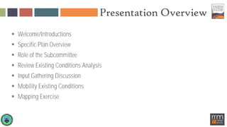
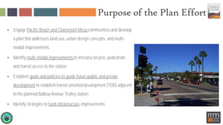
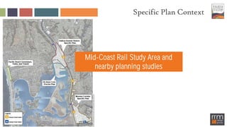
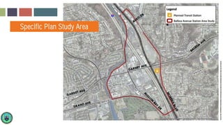
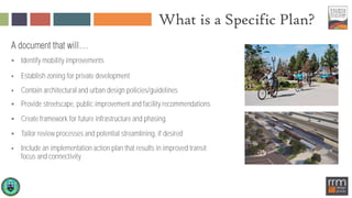
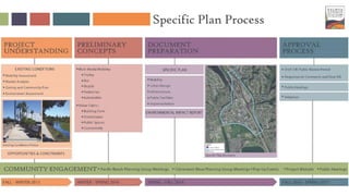
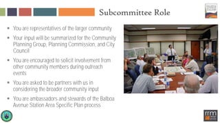
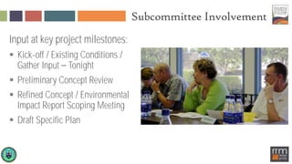
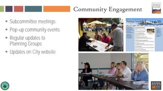
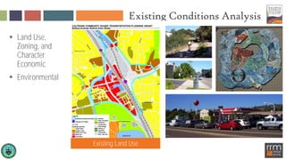
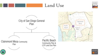
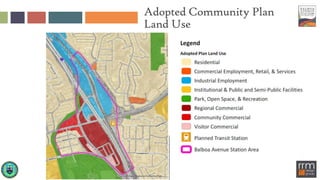
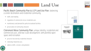
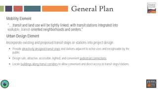
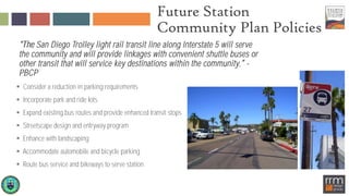
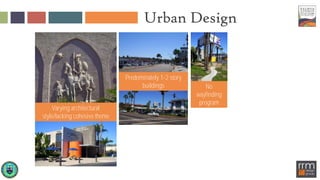
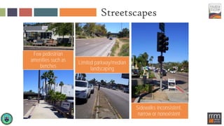
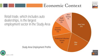
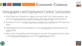
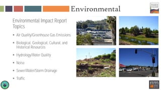
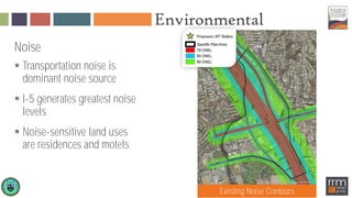
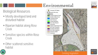
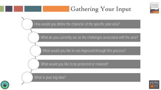
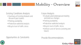
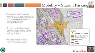
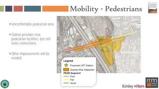
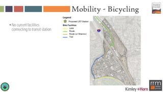
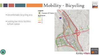
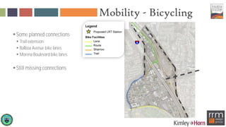
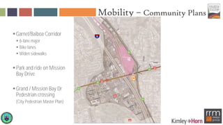
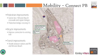
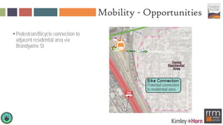
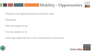
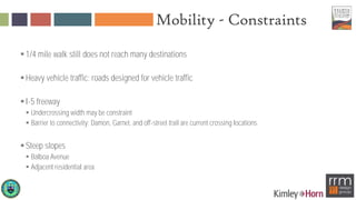
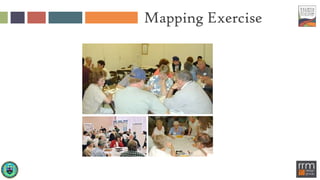
Pacific Beach Community Planning Group
December 7, 2015
Presentation Overview
 Welcome/Introductions
 Specific Plan Overview
 Role of the Subcommittee
 Review Existing Conditions Analysis
 Input Gathering Discussion
 Mobility Existing Conditions
 Mapping Exercise
Specific Plan Team
 Community Planning Groups Pacific Beach and Clairemont Mesa
 City Staff
 RRM Design Group Land Use and Urban Design
 Kimley-Horn Mobility and Parking
 HR&A Market Demand and Economics
 Helix Environmental Planning/Baranek Consulting Environmental
 Circulate San Diego Community Engagement Support
Purpose of the Plan Effort
 Engage Pacific Beach and Clairemont Mesa communities and develop
a plan that addresses land use, urban design concepts, and multi-
modal improvements
 Identify multi-modal improvements to increase bicycle, pedestrian,
and transit access to the station
 Establish goals and policies to guide future public and private
development to establish transit-oriented development (TOD) adjacent
to the planned Balboa Avenue Trolley station
 Identify strategies to fund infrastructure improvements
Specific Plan Context
Mid-Coast Rail Study Area and
nearby planning studies
Specific Plan Area
Specific Plan Study Area
What is a Specific Plan?
 Identify mobility improvements
 Establish zoning for private development
 Contain architectural and urban design policies/guidelines
 Provide streetscape, public improvement and facility recommendations
 Create framework for future infrastructure and phasing
 Tailor review processes and potential streamlining, if desired
 Include an implementation action plan that results in improved transit
focus and connectivity
Specific Plan Process
Subcommittee Role
 You are representatives of the larger community
 Your input will be summarized for the Community
Planning Group, Planning Commission, and City
Council
 You are encouraged to solicit involvement from
other community members during outreach
events
 You are asked to be partners with us in
considering the broader community input
 You are ambassadors and stewards of the Balboa
Avenue Station Area Specific Plan process
Subcommittee Involvement
Input at key project milestones:
 Kick-off / Existing Conditions /
Gather Input Tonight
 Preliminary Concept Review
 Refined Concept / Environmental
Impact Report Scoping Meeting
 Draft Specific Plan
Community Engagement
 Subcommittee meetings
 Pop-up community events
 Regular updates to
Planning Groups
 Updates on City website
Existing Conditions Analysis
 Land Use,
Zoning, and
Character
Economic
 Environmental
Existing Land Use
Land Use
Clairemont
Mesa
Pacific
Beach
City of San Diego General
Plan
Clairemont Mesa Community
Plan
Pacific Beach
Community Plan &
LCP Land Use Plan
Proposed
Station
Adopted Community Plan
Land Use
Land Use
Pacific Beach Community Plan & LCP Land Use Plan: balancing
a visitor destination and residential community
 traffic and mobility
 regulation of commercial versus residential uses
 maintenance and demand for parks/recreational facilities
 preservation of community character
Clairemont Mesa Community Plan: unique identity, residential and
commercial uses, and low-scale development, with plentiful open
space and recreation
 preserve low-density residential character
 redevelop industrial uses,
 address traffic, erosion, and pollution
General Plan
Mobility Element
walkable, transit-
Urban Design Element
Incorporate existing and proposed transit stops or stations into project design
 Provide attractively designed transit stops and stations adjacent to active uses and recognizable by the
public
 Design safe, attractive, accessible, lighted, and convenient pedestrian connections
 Locate buildings along transit corridors to allow convenient and direct access to transit stops/stations
Future Station
Community Plan Policies
San Diego Trolley light rail transit line along Interstate 5 will serve
the community and will provide linkages with convenient shuttle buses or
other transit that will service key destinations within the community -
PBCP
 Consider a reduction in parking requirements
 Incorporate park and ride lots
 Expand existing bus routes and provide enhanced transit stops
 Streetscape design and entryway program
 Enhance with landscaping
 Accommodate automobile and bicycle parking
 Route bus service and bikeways to serve station
Zoning
Residential
Commercial
Industrial
Maximum building height in
plan
Regulated by Coastal Height
Limit and Clairemont Mesa
Height Limit Overlay Zones
Revitalize Balboa Ave
Balboa Avenue
Revitalization Action Program
 In Pacific Beach, I-5 southbound ramp
landscaping improvement recommendations
included.
 Specific Plan will complement
recommendations in program.
Pacific Beach Character
Types of Uses
Retail, including auto dealerships
Professional and business services
Leisure and hospitality
Health services
Single-family residential
Urban Design
Predominately 1-2 story
buildings
Varying architectural
style/lacking cohesive theme
No
wayfinding
program
Streetscapes
Few pedestrian
amenities such as
benches
Limited parkway/median
landscaping
Sidewalks inconsistent,
narrow or nonexistent
Economic Context
Retail trade, which includes auto
dealerships, is the largest
employment sector in the Study Area
Source: LEHD
Study Area Employment Profile
Economic Context
 Pacific Beach and Clairemont are adjacent the future Mid-Coast Trolley extension, and
also have good connections to major freeways and strong visibility along Interstate 5.
 Generally, the area has a higher proportion of middle class residents than SD County as a
whole.
 High proportion of the local population is in their 20s and 30s and high proportion are
renters (94%).
 While leisure & hospitality suffered through the recession, strong gains have been made
in the Professional & Business as well as the Health Services sectors.
Demographics and Employment Context Conclusions
Market Analysis
Multifamily Residential Demand by 2035
 Study Area can capture commuters working in the UTC
area, Uptown, and Downtown.
15 Minutes to Downtown San Diego
18 Minutes to UTC
 Resident growth, turnover, and employment near Trolley
stations are projected to support 500-1,100 new
households
 Low-rise residential buildings with ground-floor retail
appropriate for the area
 Large City-owned utility yard provides a major
opportunity for future housing development
Source: US Census Longitudinal Employer-Household Dynamics (LEHD) On The Map Tool
Market Analysis
Retail & Office Demand by 2035
Retail
 10,000 SF* of additional retail, primarily in fast-casual
retail and dining, or personal/convenience stores
 20,000 to 50,000 SF of demand for groceries, personal
care, restaurants and bars
Office
 8,000-25,000 SF of office space such as dental and eye
clinic, local bank branches, and other office users med at
serving local residents
 45,000-85,000 SF of office based on the projected
growth of office-using employment and a fair share
capture
*Does not include demand that could be captured by a major shopping center.
Environmental
Environmental Impact Report
Topics
 Air Quality/Greenhouse Gas Emissions
 Biological, Geological, Cultural, and
Historical Resources
 Hydrology/Water Quality
 Noise
 Sewer/Water/Storm Drainage
 Traffic
Environmental
Noise
 Transportation noise is
dominant noise source
 I-5 generates greatest noise
levels
 Noise-sensitive land uses
are residences and motels
Existing Noise Contours
Environmental
Biological Resources
 Mostly developed land and
disturbed habitat
 Riparian habitat along Rose
Creek
 Sensitive species within Rose
Creek
 Other scattered sensitive
habitat
Existing Vegetation
Gathering Your Input
How would you define the character of the specific plan area?
What do you currently see as the challenges associated with the area?
What would you like to see improved through this process?
What would you like to be protected or retained?
What is your big idea?
Mobility - Overview
Existing Conditions Analysis
Summary of Existing Network and
Research past studies
Parking availability
Pedestrian walkshed analysis
Bicycle level of traffic stress
Opportunities & Constraints
Future Analysis
Evaluate planned/proposed mobility
and land use changes
Parking availability
Pedestrian walkshed analysis
Bicycle level of traffic stress
Vehicle Level of Service (existing and
future)
Provide Recommendations
Balboa Station Concept
Pedestrian facilities
Bicycle lockers
2 new signals on Morena
1 new signal on Balboa
Mobility – Station Parking
Station will provide on-site
parking spaces, but estimated to
not be enough to handle the
anticipated demand
There is minimal on-street
parking nearby within ¼ mile
walking distance
Alternate modes of travel
connections are needed
Mobility - Pedestrians
Uncomfortable pedestrian area
Station provides new
pedestrian facilities, but still
lacks connections
Other improvements will be
needed
Mobility - Bicycling
No current facilities
connecting to transit station
Mobility - Bicycling
Uncomfortable bicycling area
Lacking low stress facilities
to/from station
Mobility - Bicycling
Some planned connections
 Trail extension
 Balboa Avenue bike lanes
 Morena Boulevard bike lanes
Still missing connections
Mobility – Community Plans
Garnet/Balboa Corridor
 6-lane major
 Bike lanes
 Widen sidewalks
Park and ride on Mission
Bay Drive
Grand / Mission Bay Dr
Pedestrian crossing
(City Pedestrian Master Plan)
Mobility – Connect PB
Pedestrian improvements
 Garnet Ave / Mission Bay Dr
crosswalk and signal changes
 Pedestrian bridge crossing I-5
Bicycle improvements
 Improve connection to existing
trail
Transit improvements
 Shuttle between station and PB
and Mission Beach
Mobility - Opportunities
Damon Ave / Santa Fe St
bicycle connection between
station and existing trail
Mobility - Opportunities
Pedestrian/Bicycle connection to
adjacent residential area via
Brandywine St
Mobility - Opportunities
Pedestrian-scale lighting for pedestrian route to/from station
Wayfinding
Bike share program on site
Car share program on site
Utilize App-enabled ride share services; dedicate pick-up / drop-off area
Mobility - Constraints
1/4 mile walk still does not reach many destinations
Heavy vehicle traffic; roads designed for vehicle traffic
I-5 freeway
 Undercrossing width may be constraint
 Barrier to connectivity; Damon, Garnet, and off-street trail are current crossing locations
Steep slopes
 Balboa Avenue
 Adjacent residential area
Mapping Exercise

Balboa Avenue Station Presentation

  • 1.
    Pacific Beach CommunityPlanning Group December 7, 2015
  • 2.
    Presentation Overview  Welcome/Introductions Specific Plan Overview  Role of the Subcommittee  Review Existing Conditions Analysis  Input Gathering Discussion  Mobility Existing Conditions  Mapping Exercise
  • 3.
    Specific Plan Team Community Planning Groups Pacific Beach and Clairemont Mesa  City Staff  RRM Design Group Land Use and Urban Design  Kimley-Horn Mobility and Parking  HR&A Market Demand and Economics  Helix Environmental Planning/Baranek Consulting Environmental  Circulate San Diego Community Engagement Support
  • 4.
    Purpose of thePlan Effort  Engage Pacific Beach and Clairemont Mesa communities and develop a plan that addresses land use, urban design concepts, and multi- modal improvements  Identify multi-modal improvements to increase bicycle, pedestrian, and transit access to the station  Establish goals and policies to guide future public and private development to establish transit-oriented development (TOD) adjacent to the planned Balboa Avenue Trolley station  Identify strategies to fund infrastructure improvements
  • 5.
    Specific Plan Context Mid-CoastRail Study Area and nearby planning studies
  • 6.
  • 7.
    What is aSpecific Plan?  Identify mobility improvements  Establish zoning for private development  Contain architectural and urban design policies/guidelines  Provide streetscape, public improvement and facility recommendations  Create framework for future infrastructure and phasing  Tailor review processes and potential streamlining, if desired  Include an implementation action plan that results in improved transit focus and connectivity
  • 8.
  • 9.
    Subcommittee Role  Youare representatives of the larger community  Your input will be summarized for the Community Planning Group, Planning Commission, and City Council  You are encouraged to solicit involvement from other community members during outreach events  You are asked to be partners with us in considering the broader community input  You are ambassadors and stewards of the Balboa Avenue Station Area Specific Plan process
  • 10.
    Subcommittee Involvement Input atkey project milestones:  Kick-off / Existing Conditions / Gather Input Tonight  Preliminary Concept Review  Refined Concept / Environmental Impact Report Scoping Meeting  Draft Specific Plan
  • 11.
    Community Engagement  Subcommitteemeetings  Pop-up community events  Regular updates to Planning Groups  Updates on City website
  • 12.
    Existing Conditions Analysis Land Use, Zoning, and Character Economic  Environmental Existing Land Use
  • 13.
    Land Use Clairemont Mesa Pacific Beach City ofSan Diego General Plan Clairemont Mesa Community Plan Pacific Beach Community Plan & LCP Land Use Plan Proposed Station
  • 14.
  • 15.
    Land Use Pacific BeachCommunity Plan & LCP Land Use Plan: balancing a visitor destination and residential community  traffic and mobility  regulation of commercial versus residential uses  maintenance and demand for parks/recreational facilities  preservation of community character Clairemont Mesa Community Plan: unique identity, residential and commercial uses, and low-scale development, with plentiful open space and recreation  preserve low-density residential character  redevelop industrial uses,  address traffic, erosion, and pollution
  • 16.
    General Plan Mobility Element walkable,transit- Urban Design Element Incorporate existing and proposed transit stops or stations into project design  Provide attractively designed transit stops and stations adjacent to active uses and recognizable by the public  Design safe, attractive, accessible, lighted, and convenient pedestrian connections  Locate buildings along transit corridors to allow convenient and direct access to transit stops/stations
  • 17.
    Future Station Community PlanPolicies San Diego Trolley light rail transit line along Interstate 5 will serve the community and will provide linkages with convenient shuttle buses or other transit that will service key destinations within the community - PBCP  Consider a reduction in parking requirements  Incorporate park and ride lots  Expand existing bus routes and provide enhanced transit stops  Streetscape design and entryway program  Enhance with landscaping  Accommodate automobile and bicycle parking  Route bus service and bikeways to serve station
  • 18.
    Zoning Residential Commercial Industrial Maximum building heightin plan Regulated by Coastal Height Limit and Clairemont Mesa Height Limit Overlay Zones
  • 19.
    Revitalize Balboa Ave BalboaAvenue Revitalization Action Program  In Pacific Beach, I-5 southbound ramp landscaping improvement recommendations included.  Specific Plan will complement recommendations in program.
  • 20.
    Pacific Beach Character Typesof Uses Retail, including auto dealerships Professional and business services Leisure and hospitality Health services Single-family residential
  • 21.
    Urban Design Predominately 1-2story buildings Varying architectural style/lacking cohesive theme No wayfinding program
  • 22.
    Streetscapes Few pedestrian amenities suchas benches Limited parkway/median landscaping Sidewalks inconsistent, narrow or nonexistent
  • 23.
    Economic Context Retail trade,which includes auto dealerships, is the largest employment sector in the Study Area Source: LEHD Study Area Employment Profile
  • 24.
    Economic Context  PacificBeach and Clairemont are adjacent the future Mid-Coast Trolley extension, and also have good connections to major freeways and strong visibility along Interstate 5.  Generally, the area has a higher proportion of middle class residents than SD County as a whole.  High proportion of the local population is in their 20s and 30s and high proportion are renters (94%).  While leisure & hospitality suffered through the recession, strong gains have been made in the Professional & Business as well as the Health Services sectors. Demographics and Employment Context Conclusions
  • 25.
    Market Analysis Multifamily ResidentialDemand by 2035  Study Area can capture commuters working in the UTC area, Uptown, and Downtown. 15 Minutes to Downtown San Diego 18 Minutes to UTC  Resident growth, turnover, and employment near Trolley stations are projected to support 500-1,100 new households  Low-rise residential buildings with ground-floor retail appropriate for the area  Large City-owned utility yard provides a major opportunity for future housing development Source: US Census Longitudinal Employer-Household Dynamics (LEHD) On The Map Tool
  • 26.
    Market Analysis Retail &Office Demand by 2035 Retail  10,000 SF* of additional retail, primarily in fast-casual retail and dining, or personal/convenience stores  20,000 to 50,000 SF of demand for groceries, personal care, restaurants and bars Office  8,000-25,000 SF of office space such as dental and eye clinic, local bank branches, and other office users med at serving local residents  45,000-85,000 SF of office based on the projected growth of office-using employment and a fair share capture *Does not include demand that could be captured by a major shopping center.
  • 27.
    Environmental Environmental Impact Report Topics Air Quality/Greenhouse Gas Emissions  Biological, Geological, Cultural, and Historical Resources  Hydrology/Water Quality  Noise  Sewer/Water/Storm Drainage  Traffic
  • 28.
    Environmental Noise  Transportation noiseis dominant noise source  I-5 generates greatest noise levels  Noise-sensitive land uses are residences and motels Existing Noise Contours
  • 29.
    Environmental Biological Resources  Mostlydeveloped land and disturbed habitat  Riparian habitat along Rose Creek  Sensitive species within Rose Creek  Other scattered sensitive habitat Existing Vegetation
  • 30.
    Gathering Your Input Howwould you define the character of the specific plan area? What do you currently see as the challenges associated with the area? What would you like to see improved through this process? What would you like to be protected or retained? What is your big idea?
  • 31.
    Mobility - Overview ExistingConditions Analysis Summary of Existing Network and Research past studies Parking availability Pedestrian walkshed analysis Bicycle level of traffic stress Opportunities & Constraints Future Analysis Evaluate planned/proposed mobility and land use changes Parking availability Pedestrian walkshed analysis Bicycle level of traffic stress Vehicle Level of Service (existing and future) Provide Recommendations
  • 32.
    Balboa Station Concept Pedestrianfacilities Bicycle lockers 2 new signals on Morena 1 new signal on Balboa
  • 33.
    Mobility – StationParking Station will provide on-site parking spaces, but estimated to not be enough to handle the anticipated demand There is minimal on-street parking nearby within ¼ mile walking distance Alternate modes of travel connections are needed
  • 34.
    Mobility - Pedestrians Uncomfortablepedestrian area Station provides new pedestrian facilities, but still lacks connections Other improvements will be needed
  • 35.
    Mobility - Bicycling Nocurrent facilities connecting to transit station
  • 36.
    Mobility - Bicycling Uncomfortablebicycling area Lacking low stress facilities to/from station
  • 37.
    Mobility - Bicycling Someplanned connections  Trail extension  Balboa Avenue bike lanes  Morena Boulevard bike lanes Still missing connections
  • 38.
    Mobility – CommunityPlans Garnet/Balboa Corridor  6-lane major  Bike lanes  Widen sidewalks Park and ride on Mission Bay Drive Grand / Mission Bay Dr Pedestrian crossing (City Pedestrian Master Plan)
  • 39.
    Mobility – ConnectPB Pedestrian improvements  Garnet Ave / Mission Bay Dr crosswalk and signal changes  Pedestrian bridge crossing I-5 Bicycle improvements  Improve connection to existing trail Transit improvements  Shuttle between station and PB and Mission Beach
  • 40.
    Mobility - Opportunities DamonAve / Santa Fe St bicycle connection between station and existing trail
  • 41.
    Mobility - Opportunities Pedestrian/Bicycleconnection to adjacent residential area via Brandywine St
  • 42.
    Mobility - Opportunities Pedestrian-scalelighting for pedestrian route to/from station Wayfinding Bike share program on site Car share program on site Utilize App-enabled ride share services; dedicate pick-up / drop-off area
  • 43.
    Mobility - Constraints 1/4mile walk still does not reach many destinations Heavy vehicle traffic; roads designed for vehicle traffic I-5 freeway  Undercrossing width may be constraint  Barrier to connectivity; Damon, Garnet, and off-street trail are current crossing locations Steep slopes  Balboa Avenue  Adjacent residential area
  • 44.