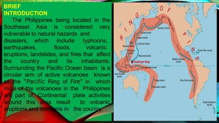
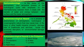
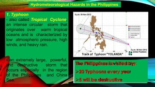
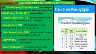
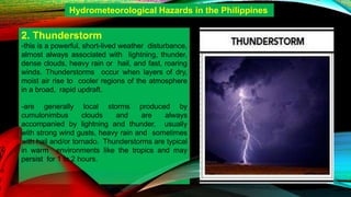
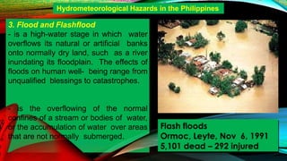
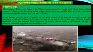
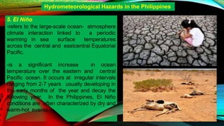
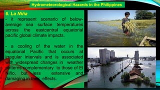
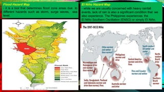
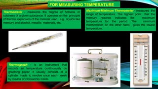
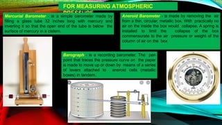
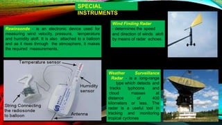
Lesson Objectives:
a. Define hydrometeorological hazards
b. Identify the different hydrometeorological hazards
c. Interpret different hydrometeorological hazard
maps.
d. Identify the different monitoring tools for
hydrometeorological hazards.
BRIEF
INTRODUCTION
The Philippines being located in the
Southeast Asia is considered very
vulnerable to natural hazards and
disasters, which include
earthquakes, floods,
typhoons,
volcanic
eruptions, landslides, and fires that affect
the country and its inhabitants.
Surrounding the Pacific Ocean basin is a
circular arm of active volcanoes known
as the “Pacific Ring of Fire” in which
most of the volcanoes in the Philippines
are part of. Continental plate activities
around this area result to volcanic
eruptions and tsunamis in the country.
atmospheric and terrestrial phases of
Hydrometeorology - is the study of the
the
hydrological cycle with emphasis on the
interrelationship between them. It deals with the
transfer of water and energy between land
surface and the lower atmosphere.
Hydrometeorological Hazard - is a process or
phenomenon of atmospheric, hydrological or
oceanographic nature that may cause loss of life,
injury or other health impacts, property damage,
loss of livelihoods and services, social and
economic disruption, or environmental damage.
(UNISDR)
Hydrometeorological Hazards in the Philippines
5. Storm Surge
6. El Niño
7. La Niña
1. Typhoon
2. Thunderstorm
3. Flood
4. Flash Flood
- an extremely large, powerful,
and destructive storm that
occurs especially in the region
of the Philippines and China
Sea.
Hydrometeorological Hazards in the Philippines
1. Typhoon
- also called Tropical Cyclone,
an intense circular storm that
originates over warm tropical
oceans and is characterized by
low atmospheric pressure, high
winds, and heavy rain.
The Philippines is visited by:
20 Typhoons every year
5 will be destructive
Hydrometeorological Hazards in the Philippines
2. Thunderstorm
-this is a powerful, short-lived weather disturbance,
almost always associated with lightning, thunder,
dense clouds, heavy rain or hail, and fast, roaring
winds. Thunderstorms occur when layers of dry,
moist air rise to cooler regions of the atmosphere
in a broad, rapid updraft.
-are generally local storms produced by
cumulonimbus clouds and are always
accompanied by lightning and thunder, usually
with strong wind gusts, heavy rain and sometimes
with hail and/or tornado. Thunderstorms are typical
in warm environments like the tropics and may
persist for 1 to 2 hours.
Hydrometeorological Hazards in the Philippines
- is the overflowing of the normal
confines of a stream or bodies of water,
or the accumulation of water over areas
that are not normally submerged.
Hydrometeorological Hazards in the Philippines
3. Flood and Flashflood
- is a high-water stage in which water
overflows its natural or artificial banks
onto normally dry land, such as a river
inundating its floodplain. The effects of
floods on human well- being range from
unqualified blessings to catastrophes.
Flash floods
Ormoc, Leyte, Nov 6, 1991
5,101 dead – 292 injured
4. Storm Surge
-Storm surge or "Daluyong ng Bagyo" in the Philippine system where the irregular sea-level rise during tropical
cyclone or "bagyo" occurs. When the tropical cyclone reaches the coast, powerful winds force the ocean water
over the coastal low-lying areas, which can lead to flooding.
-is the rise and onshore surge of seawater as the result primarily of the winds of a tropical cyclone, and
secondarily of the surface pressure drop near the center of the tropical cyclone. The height of storm surge is
dependent on the size, intensity and movement of the tropical cyclone, shape of the coastline as well as
nearshore underwater topography and astronomical tides.
Hydrometeorological Hazards in the Philippines
5. El Niño
-refers to the large-scale ocean- atmosphere
climate interaction linked to a periodic
warming in sea surface temperatures
across the central and eastcentral Equatorial
Pacific.
-is a significant increase in ocean
temperature over the eastern and central
Pacific ocean. It occurs at irregular intervals
ranging from 2-7 years usually developing in
the early months of the year and decay the
following year. In the Philippines, El Niño
conditions are often characterized by dry and
warm-hot events.
Hydrometeorological Hazards in the Philippines
6. La Niña
- it represent scenario of below-
average sea surface temperatures
across the eastcentral equatorial
pacific global climate impacts.
- a cooling of the water in the
equatorial Pacific that occurs at
irregular intervals and is associated
with widespread changes in weather
patterns complementary to those of El
Niño, but less extensive and
damaging in their effects.
Hydrometeorological Hazards in the Philippines
Nationwide Operational Assessment of
Hazards or (NOAH) - a program under
the Department of Science and
Technology (DOST), advance the use
of cutting-edge technology and
recommend innovative information
services in government’s disaster
prevention and mitigation efforts. DOST-
NOAH can be accessed online at
http://noah.up.edu.ph/ which displays the
PAGASA radar data, rainfall
measurements of rain gauges of DOST,
and has flood hazard maps in the
Philippines. Below is a screen shot from
the Project NOAH web page, indicating
the flood prone areas of Manila. Note the
meaning of the colors indicated on the left
of the screen shot
Return Period - also referred to as
recurrence interval, is the probability of an
event such as heavy rain, intense typhoon
of floods to happen. It is a statistical
measurement mainly based
on historical data that gives the estimated
time interval between similar extreme
events. For example, the return period of a
heavy rainfall event is 100 years, this can
be expressed as an even with a probability
of happening equivalent to 1/100 or 1%.
This does not mean that the next similar
extreme event will happen 100 years after,
instead, it means that in a given year, there
is a 1% chance that the event will happen.
Rainfall Map - A Modified Coronas Climate Classification
shows the monthly rainfall variations in the Philippines:
Rainfall distribution throughout the country varies from
one region to another, depending upon the direction of the
winds and the location of mountain systems.
Hazard Map
- is a map that highlights areas that
are affected by or are vulnerable to a
particular hazard.
They are typically created for
natural hazards, such as
earthquakes, volcanoes,
landslides, flooding, and tsunamis.
Hazard maps help prevent serious
damage and deaths.
- highlight areas that are affected
and/or vulnerable to a particular
hazard and help prevent serious
damage and deaths.
The image is color coded depending on the
amount of rain a cloud carries:
Blue – light rain
Green/Yellow – moderate rain
Red – intense rain
El Niño Hazard Map
- while we are usually concerned with heavy rainfall
events, lack of rain is also a significant condition that we
also experience. The Philippines experiences the
El Niño Southern Oscillation (ENSO) or simply El Niño.
Flood Hazard Map
- it is a tool that determines flood zone areas due to
different hazards such as storm, surge waves, sea
level.
BRIEF INTRODUCTION
In the Philippines, the government agency
tasked to monitor the weather, and give
forecasts and warnings about atmospheric
condition is the PAGASA, or Philippine
Atmospheric, Geophysical and
Astronomical Services Administration.
Unlike an earthquake, forecasts pertaining to
hydrometeorological hazards are easier to
predict with the help of some important tools
which can monitor atmospheric conditions.
MONITORING TOOLS FOR HYDROMETEOROLOGICAL
HAZARDS
Thermometer - measures the degree of hotness or
coldness of a given substance. It operates on the principle
of thermal expansion of the material used, e.g., liquids like
mercury and alcohol, metallic materials, etc.
Maximum-Minimum Thermometer - measures the
range of temperature. The highest point that the
mercury reaches indicates the maximum
temperature for the period. The minimum
thermometer, on the other hand, gives the lowest
temperature.
Thermograph - is an instrument that
records air temperature continuously on
graphing paper. It usually consists of a
cylinder made to revolve once each week
by means of clockworks inside.
FOR MEASURING TEMPERATURE
FOR MEASURING ATMOSPHERIC
PRESSURE
Mercurial Barometer - is a simple barometer made by
filling a glass tube 32 inches long with mercury and
inverting it so that the open end of the tube is below the
surface of mercury in a cistern.
Aneroid Barometer - is made by removing the air
from a thin, circular, metallic box. With practically no
air on the inside the box would collapse. A spring is
installed to limit the collapse of the box
commensurate to the air pressure or weight of the
column of air on the box
Barograph - is a recording barometer. The pen
point that traces the pressure curve on the paper
is made to move up or down by means of a series
of levers attached to aneroid cells (metallic
boxes) in tandem.
FOR MEASURING ATMOSPHERIC
HUMIDITY
Sling Psychrometer - consists of a dry and
wet-bulb thermometer. The term bulb refers to
that portion of the glass tube where the
mercury is stored. The only difference between
dry and wet bulbs is that the wet- bulb has a
piece of muslin cloth or wick wrapped around
its bulb and which is dipped in water shortly
before the psychrometer is read.
Hygrometer - uses human hair from which the oil has
been removed by using ether. The hair becomes longer
as the relative humidity of the air increases.
Hygrothermograph
- records both relative
humidity and
temperature on graph
paper in the same manner
as the
thermograph and
barograph do.
FOR MEASURING
PRECIPITATION
8-inch Rain Gauge - is called as
such because the inside diameter of
the collector is exactly 8 inches
above a funnel that conducts rain into
a cylindrical measuring tube or
receiver. The volume of the collector
is 10 times the volume of the
measuring tube.
Tipping Bucket Rain Gauge - is
an upright cylinder that has funnel
shaped collector. The precipitation
collected by the collector empties
into one side of a "tipping bucket",
an inverted triangular contraption
partitioned transversely at its
center, and is pivoted about a
horizontal axis. Once one
compartment is filled with rain, it
tips, spilling out the water and
placing the other half of the bucket
under the funnel. The tipping
activates a mercury switch causing
an electrical current to move the
pen in the recorder. Each tipping is
equal to one-half millimeter of
rainfall.
FOR MEASURING
CLOUDS
Ceiling Light Projector - projects vertically a narrow
beam of light on to a cloud base. The height of the
cloud base is determined by using a clinometer
located at a known distance from the projector to
measure the elevation angle included by the
illuminated spot on the cloud, the observe, and the
projector.
Meteorological Balloon - whose rate of ascent has
been predetermined. It is filled with gas lighter than air,
usually hydrogen, and released. The time of release
and the time the balloon disappears into the cloud are
recorded. The time difference multiplied by the rate of
ascent will give the height of the cloud base.
SPECIAL
INSTRUMENTS
Pilot Meteorological Balloon - is filled
with gas lighter than air. When the pilot
balloon is used in conjunction with a
theodolite it is used to determine the
speed and direction of winds at different
levels of the atmosphere.
Radiosonde - is an airborne instrument used for
measuring pressure, temperature and relative
humidity in the upper air. The radiosonde has a
built-in high frequency transmitter that transmits
data from the radiosonde meter and recorded on the
ground by a specially designed radiosonde receiver.
SPECIAL
INSTRUMENTS
Rawinsonde - is an electronic device used for
measuring wind velocity, pressure, temperature
and humidity aloft. It is also attached to a balloon
and as it rises through the atmosphere, it makes
the required measurements.
Wind Finding Radar
- determines the speed
and direction of winds aloft
by means of radar echoes.
distance of
Weather Surveillance
Radar - is a long-range
type which detects and
tracks typhoons and
cloud masses at
400
kilometers or less. The
radar is a useful tool in
tracking and monitoring
tropical cyclones
*Hydrometeorological Hazard is a process or phenomenon of
atmospheric, hydrological or oceanographic nature that may cause loss
of life, injury or other health impacts, property damage, loss of
livelihoods and services, social and economic disruption, or
environmental damage.
* Hydrometeorological Hazards include Typhoon, thunderstorm,
flashflood, flood, storm surges, El Niño, and La Niña.
* A Hazard Map is a map that highlights areas that are affected by
or are vulnerable to a particular hazard.
* There are Monitoring Tools for Hydrometeorological Hazards such
as tools for measuring temperature, measuring atmospheric pressure,
measuring atmospheric humidity, measuring precipitation, measuring
DRRR PERFORMANCE TASK WEEK 3 – 3RD
QUARTER
Send the video to my fb messenger
on or before April 24, 2021 (Saturday)
WEATHER FORECASTING
*Make a 2-minute video of a weather
forecast in Metro Manila (watch
example weather forecasting of Mang
Tani in 24 Oras GMA 7 or weather
forecast of PAGASA).
* Use visual aid or any related
graphic device for your
weather forecast
* Have an interesting trivia at
the end of your report.
* Kindly refer to the criteria in
order for you to get the
possible highest score (20 points).
5 points 4 points 3 points 2 points
Weather forecast All of the required All but 1 of the Several required
included cloud type, elements are included
in
required elements is elements are missing
weather, temperature, the forecast. included in the from the forecast.
Content precipitation, forecast.
highs/lows, fronts, as
well as additional
information.
Explanation of the Explanation of the Explanation of the Explanation of the
weather forecast shows
a
weather forecast shows weather forecast weather forecast shows a
Reasoning complete understanding a fairly good shows some slight understanding of
of weather systems understanding of understanding of weather systems
weather systems weather systems
Weather map complete Weather map or
forecast
Weather map or Weather map with no
with proper use of with partial or incorrect forecast, no use of symbols or icons OR
good
Visual Aid symbols, or forecast with use of symbols or icons, symbols or icons, map but too small for the
icons, large enough for large enough for the but large enough for audience to see.
the audience to see. audience to see. the audience to see.
Presentation is very Presentation is pretty Presentation is Presentation is very
smooth and shows much smooth and presenters somewhat choppy choppy and/or
time spent preparing. mostly used eye
contact,
and presenters had presenters lacked
Presentation Presenters used eye good posture, and had trouble with eye preparation for their
contact, good posture good clarity and
volume.
contact, posture, presentation.
and were very clear and clarity and volume.
loud enough.
Source: https://www.youtube.com/watch?v=dBtgXVjBknU

hydrometeorological-hazard-t. kris..pptx

  • 1.
    Lesson Objectives: a. Definehydrometeorological hazards b. Identify the different hydrometeorological hazards c. Interpret different hydrometeorological hazard maps. d. Identify the different monitoring tools for hydrometeorological hazards.
  • 2.
    BRIEF INTRODUCTION The Philippines beinglocated in the Southeast Asia is considered very vulnerable to natural hazards and disasters, which include earthquakes, floods, typhoons, volcanic eruptions, landslides, and fires that affect the country and its inhabitants. Surrounding the Pacific Ocean basin is a circular arm of active volcanoes known as the “Pacific Ring of Fire” in which most of the volcanoes in the Philippines are part of. Continental plate activities around this area result to volcanic eruptions and tsunamis in the country.
  • 3.
    atmospheric and terrestrialphases of Hydrometeorology - is the study of the the hydrological cycle with emphasis on the interrelationship between them. It deals with the transfer of water and energy between land surface and the lower atmosphere. Hydrometeorological Hazard - is a process or phenomenon of atmospheric, hydrological or oceanographic nature that may cause loss of life, injury or other health impacts, property damage, loss of livelihoods and services, social and economic disruption, or environmental damage. (UNISDR) Hydrometeorological Hazards in the Philippines 5. Storm Surge 6. El Niño 7. La Niña 1. Typhoon 2. Thunderstorm 3. Flood 4. Flash Flood
  • 4.
    - an extremelylarge, powerful, and destructive storm that occurs especially in the region of the Philippines and China Sea. Hydrometeorological Hazards in the Philippines 1. Typhoon - also called Tropical Cyclone, an intense circular storm that originates over warm tropical oceans and is characterized by low atmospheric pressure, high winds, and heavy rain. The Philippines is visited by: 20 Typhoons every year 5 will be destructive
  • 5.
  • 6.
    2. Thunderstorm -this isa powerful, short-lived weather disturbance, almost always associated with lightning, thunder, dense clouds, heavy rain or hail, and fast, roaring winds. Thunderstorms occur when layers of dry, moist air rise to cooler regions of the atmosphere in a broad, rapid updraft. -are generally local storms produced by cumulonimbus clouds and are always accompanied by lightning and thunder, usually with strong wind gusts, heavy rain and sometimes with hail and/or tornado. Thunderstorms are typical in warm environments like the tropics and may persist for 1 to 2 hours. Hydrometeorological Hazards in the Philippines
  • 7.
    - is theoverflowing of the normal confines of a stream or bodies of water, or the accumulation of water over areas that are not normally submerged. Hydrometeorological Hazards in the Philippines 3. Flood and Flashflood - is a high-water stage in which water overflows its natural or artificial banks onto normally dry land, such as a river inundating its floodplain. The effects of floods on human well- being range from unqualified blessings to catastrophes. Flash floods Ormoc, Leyte, Nov 6, 1991 5,101 dead – 292 injured
  • 8.
    4. Storm Surge -Stormsurge or "Daluyong ng Bagyo" in the Philippine system where the irregular sea-level rise during tropical cyclone or "bagyo" occurs. When the tropical cyclone reaches the coast, powerful winds force the ocean water over the coastal low-lying areas, which can lead to flooding. -is the rise and onshore surge of seawater as the result primarily of the winds of a tropical cyclone, and secondarily of the surface pressure drop near the center of the tropical cyclone. The height of storm surge is dependent on the size, intensity and movement of the tropical cyclone, shape of the coastline as well as nearshore underwater topography and astronomical tides. Hydrometeorological Hazards in the Philippines
  • 9.
    5. El Niño -refersto the large-scale ocean- atmosphere climate interaction linked to a periodic warming in sea surface temperatures across the central and eastcentral Equatorial Pacific. -is a significant increase in ocean temperature over the eastern and central Pacific ocean. It occurs at irregular intervals ranging from 2-7 years usually developing in the early months of the year and decay the following year. In the Philippines, El Niño conditions are often characterized by dry and warm-hot events. Hydrometeorological Hazards in the Philippines
  • 10.
    6. La Niña -it represent scenario of below- average sea surface temperatures across the eastcentral equatorial pacific global climate impacts. - a cooling of the water in the equatorial Pacific that occurs at irregular intervals and is associated with widespread changes in weather patterns complementary to those of El Niño, but less extensive and damaging in their effects. Hydrometeorological Hazards in the Philippines
  • 11.
    Nationwide Operational Assessmentof Hazards or (NOAH) - a program under the Department of Science and Technology (DOST), advance the use of cutting-edge technology and recommend innovative information services in government’s disaster prevention and mitigation efforts. DOST- NOAH can be accessed online at http://noah.up.edu.ph/ which displays the PAGASA radar data, rainfall measurements of rain gauges of DOST, and has flood hazard maps in the Philippines. Below is a screen shot from the Project NOAH web page, indicating the flood prone areas of Manila. Note the meaning of the colors indicated on the left of the screen shot Return Period - also referred to as recurrence interval, is the probability of an event such as heavy rain, intense typhoon of floods to happen. It is a statistical measurement mainly based on historical data that gives the estimated time interval between similar extreme events. For example, the return period of a heavy rainfall event is 100 years, this can be expressed as an even with a probability of happening equivalent to 1/100 or 1%. This does not mean that the next similar extreme event will happen 100 years after, instead, it means that in a given year, there is a 1% chance that the event will happen.
  • 12.
    Rainfall Map -A Modified Coronas Climate Classification shows the monthly rainfall variations in the Philippines: Rainfall distribution throughout the country varies from one region to another, depending upon the direction of the winds and the location of mountain systems. Hazard Map - is a map that highlights areas that are affected by or are vulnerable to a particular hazard. They are typically created for natural hazards, such as earthquakes, volcanoes, landslides, flooding, and tsunamis. Hazard maps help prevent serious damage and deaths. - highlight areas that are affected and/or vulnerable to a particular hazard and help prevent serious damage and deaths. The image is color coded depending on the amount of rain a cloud carries: Blue – light rain Green/Yellow – moderate rain Red – intense rain
  • 13.
    El Niño HazardMap - while we are usually concerned with heavy rainfall events, lack of rain is also a significant condition that we also experience. The Philippines experiences the El Niño Southern Oscillation (ENSO) or simply El Niño. Flood Hazard Map - it is a tool that determines flood zone areas due to different hazards such as storm, surge waves, sea level.
  • 14.
    BRIEF INTRODUCTION In thePhilippines, the government agency tasked to monitor the weather, and give forecasts and warnings about atmospheric condition is the PAGASA, or Philippine Atmospheric, Geophysical and Astronomical Services Administration. Unlike an earthquake, forecasts pertaining to hydrometeorological hazards are easier to predict with the help of some important tools which can monitor atmospheric conditions. MONITORING TOOLS FOR HYDROMETEOROLOGICAL HAZARDS
  • 15.
    Thermometer - measuresthe degree of hotness or coldness of a given substance. It operates on the principle of thermal expansion of the material used, e.g., liquids like mercury and alcohol, metallic materials, etc. Maximum-Minimum Thermometer - measures the range of temperature. The highest point that the mercury reaches indicates the maximum temperature for the period. The minimum thermometer, on the other hand, gives the lowest temperature. Thermograph - is an instrument that records air temperature continuously on graphing paper. It usually consists of a cylinder made to revolve once each week by means of clockworks inside. FOR MEASURING TEMPERATURE
  • 16.
    FOR MEASURING ATMOSPHERIC PRESSURE MercurialBarometer - is a simple barometer made by filling a glass tube 32 inches long with mercury and inverting it so that the open end of the tube is below the surface of mercury in a cistern. Aneroid Barometer - is made by removing the air from a thin, circular, metallic box. With practically no air on the inside the box would collapse. A spring is installed to limit the collapse of the box commensurate to the air pressure or weight of the column of air on the box Barograph - is a recording barometer. The pen point that traces the pressure curve on the paper is made to move up or down by means of a series of levers attached to aneroid cells (metallic boxes) in tandem.
  • 17.
    FOR MEASURING ATMOSPHERIC HUMIDITY SlingPsychrometer - consists of a dry and wet-bulb thermometer. The term bulb refers to that portion of the glass tube where the mercury is stored. The only difference between dry and wet bulbs is that the wet- bulb has a piece of muslin cloth or wick wrapped around its bulb and which is dipped in water shortly before the psychrometer is read. Hygrometer - uses human hair from which the oil has been removed by using ether. The hair becomes longer as the relative humidity of the air increases. Hygrothermograph - records both relative humidity and temperature on graph paper in the same manner as the thermograph and barograph do.
  • 18.
    FOR MEASURING PRECIPITATION 8-inch RainGauge - is called as such because the inside diameter of the collector is exactly 8 inches above a funnel that conducts rain into a cylindrical measuring tube or receiver. The volume of the collector is 10 times the volume of the measuring tube. Tipping Bucket Rain Gauge - is an upright cylinder that has funnel shaped collector. The precipitation collected by the collector empties into one side of a "tipping bucket", an inverted triangular contraption partitioned transversely at its center, and is pivoted about a horizontal axis. Once one compartment is filled with rain, it tips, spilling out the water and placing the other half of the bucket under the funnel. The tipping activates a mercury switch causing an electrical current to move the pen in the recorder. Each tipping is equal to one-half millimeter of rainfall.
  • 19.
    FOR MEASURING CLOUDS Ceiling LightProjector - projects vertically a narrow beam of light on to a cloud base. The height of the cloud base is determined by using a clinometer located at a known distance from the projector to measure the elevation angle included by the illuminated spot on the cloud, the observe, and the projector. Meteorological Balloon - whose rate of ascent has been predetermined. It is filled with gas lighter than air, usually hydrogen, and released. The time of release and the time the balloon disappears into the cloud are recorded. The time difference multiplied by the rate of ascent will give the height of the cloud base.
  • 20.
    SPECIAL INSTRUMENTS Pilot Meteorological Balloon- is filled with gas lighter than air. When the pilot balloon is used in conjunction with a theodolite it is used to determine the speed and direction of winds at different levels of the atmosphere. Radiosonde - is an airborne instrument used for measuring pressure, temperature and relative humidity in the upper air. The radiosonde has a built-in high frequency transmitter that transmits data from the radiosonde meter and recorded on the ground by a specially designed radiosonde receiver.
  • 21.
    SPECIAL INSTRUMENTS Rawinsonde - isan electronic device used for measuring wind velocity, pressure, temperature and humidity aloft. It is also attached to a balloon and as it rises through the atmosphere, it makes the required measurements. Wind Finding Radar - determines the speed and direction of winds aloft by means of radar echoes. distance of Weather Surveillance Radar - is a long-range type which detects and tracks typhoons and cloud masses at 400 kilometers or less. The radar is a useful tool in tracking and monitoring tropical cyclones
  • 22.
    *Hydrometeorological Hazard isa process or phenomenon of atmospheric, hydrological or oceanographic nature that may cause loss of life, injury or other health impacts, property damage, loss of livelihoods and services, social and economic disruption, or environmental damage. * Hydrometeorological Hazards include Typhoon, thunderstorm, flashflood, flood, storm surges, El Niño, and La Niña. * A Hazard Map is a map that highlights areas that are affected by or are vulnerable to a particular hazard. * There are Monitoring Tools for Hydrometeorological Hazards such as tools for measuring temperature, measuring atmospheric pressure, measuring atmospheric humidity, measuring precipitation, measuring
  • 23.
    DRRR PERFORMANCE TASKWEEK 3 – 3RD QUARTER Send the video to my fb messenger on or before April 24, 2021 (Saturday) WEATHER FORECASTING *Make a 2-minute video of a weather forecast in Metro Manila (watch example weather forecasting of Mang Tani in 24 Oras GMA 7 or weather forecast of PAGASA). * Use visual aid or any related graphic device for your weather forecast * Have an interesting trivia at the end of your report. * Kindly refer to the criteria in order for you to get the possible highest score (20 points). 5 points 4 points 3 points 2 points Weather forecast All of the required All but 1 of the Several required included cloud type, elements are included in required elements is elements are missing weather, temperature, the forecast. included in the from the forecast. Content precipitation, forecast. highs/lows, fronts, as well as additional information. Explanation of the Explanation of the Explanation of the Explanation of the weather forecast shows a weather forecast shows weather forecast weather forecast shows a Reasoning complete understanding a fairly good shows some slight understanding of of weather systems understanding of understanding of weather systems weather systems weather systems Weather map complete Weather map or forecast Weather map or Weather map with no with proper use of with partial or incorrect forecast, no use of symbols or icons OR good Visual Aid symbols, or forecast with use of symbols or icons, symbols or icons, map but too small for the icons, large enough for large enough for the but large enough for audience to see. the audience to see. audience to see. the audience to see. Presentation is very Presentation is pretty Presentation is Presentation is very smooth and shows much smooth and presenters somewhat choppy choppy and/or time spent preparing. mostly used eye contact, and presenters had presenters lacked Presentation Presenters used eye good posture, and had trouble with eye preparation for their contact, good posture good clarity and volume. contact, posture, presentation. and were very clear and clarity and volume. loud enough.
  • 24.