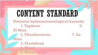
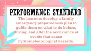
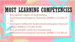
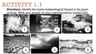
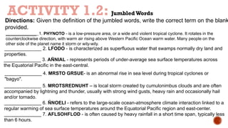
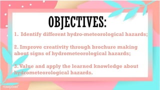
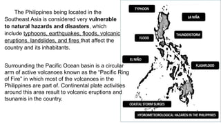
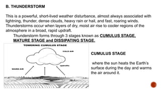
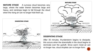
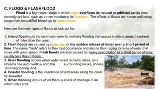
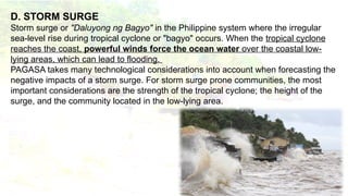
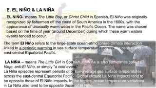
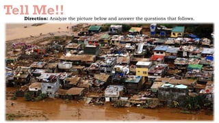
Good
Afternoon!!!
DISASTER
READINESS AND
RISK REDUCTION
COT-1 QUARTER 2
CONTENT STANDARD
Potential hydrometeorological hazards:
1.Typhoon 6.
El Nino
2.Thunderstorm 7. La
Nina
3. Flashflood
4. Flood
5. Storm surge
PERFORMANCE STANDARD
The learners develop a family
emergency preparedness plan to
guide them on what to do before,
during, and after the occurrence of
events that cause
hydrometeorological hazards.
MOST LEARNING COMPETENCIES
 Recognize signs of impending
hydrometeorological hazards (DRR11/12-IIc-d-
33)
 Interpret different hydrometeorological hazard
maps (DRR11/12-IIc-d-35)
 Use available tools for monitoring
hydrometeorological hazards (DRR11/12-IIc-d-
36)
Picture Perfect!
Direction: Match the sketches with their
corresponding terms. Then, if the sketch
shows a geological hazard, write GEO; if it
shows a hydrometeorological hazard, write
HYDRO. Write your answers on the table that
follows.
HAZARD LETTER CLASSIFICATION
1. Drought
2. Flood
3.Tsunami
4. Landslide
5. Bushfire
6. Earthquake
7.Tornado
8.Typhoon
9.Volcanic eruption
Prepare yourself !!
Direction: Given the PICTURE below write the correct term on the
blank provided
THE ANSWER is…..
P R E V E N T I O N
I E E
E
T T
T
R
R
N
S
H A
B
C U
ACTIVITY 1.1
Directions: Identify the Hydro-meteorological Hazard in the given
pictures. Write your answer on your Learning Activity Guide(LAG).
ACTIVITY 1.2: JumbledWords
Directions: Given the definition of the jumbled words, write the correct term on the blank
provided.
_____________ 1. PHYNOTO - is a low-pressure area, or a wide and violent tropical cyclone. It rotates in the
counterclockwise direction, with warm air rising above Western Pacific Ocean warm water. Many people on the
other side of the planet name it storm or wily-wily.
______________ 2. LFODO - is characterized as superfluous water that swamps normally dry land and
properties.
______________ 3. AÑNIAL - represents periods of under-average sea surface temperatures across
the Equatorial Pacific in the east-central.
______________ 4. MRSTO GRSUE- is an abnormal rise in sea level during tropical cyclones or
"bagyo".
______________ 5. MROTSREDNUHT – is local storm created by cumulonimbus clouds and are often
accompanied by lightning and thunder, usually with strong wind gusts, heavy rain and occasionally hail
and/or tornado.
______________ 6. ÑNOELI - refers to the large-scale ocean-atmosphere climate interaction linked to a
regular warming of sea surface temperatures around the Equatorial Pacific region and east-center.
______________ 7. AFLSOHFLOD - is often caused by heavy rainfall in a short time span, typically less
than 6 hours.
HYDROMETEOROLOGICAL
HAZARDS
PROPER DISCUSSION
OBJECTIVES:
1. Identify different hydro-meteorological hazards;
2. Improve creativity through brochure making
about signs of hydrometeorological hazards;
3.Value and apply the learned knowledge about
hydrometeorological hazards.
The Philippines being located in the
Southeast Asia is considered very vulnerable
to natural hazards and disasters, which
include typhoons, earthquakes, floods, volcanic
eruptions, landslides, and fires that affect the
country and its inhabitants.
Surrounding the Pacific Ocean basin is a circular
arm of active volcanoes known as the “Pacific Ring
of Fire” in which most of the volcanoes in the
Philippines are part of. Continental plate activities
around this area result to volcanic eruptions and
tsunamis in the country.
National Disaster Management Plan of 2016 stated that
HYDROMETEOROLOGICAL is a process or phenomenon of
atmospheric, hydrological or oceanographic nature that may cause
loss of life, injury or other health impacts, property damage, loss of
livelihoods and services, social and economic disruption, or
environmental damage.
Hydrometeorological hazards include:
1. Typhoon 4. Thunderstorm
2. Flood 5. Flashflood
3. Storm Surge 6. El Niño
7. La Niña
Hydrometeorological conditions lead to other hazards such as
landslides, fires, plagues, epidemics and in transport and dispersal of
toxic substances and volcanic eruption material.
SIGN OF IMPENDING
HYDROMETEOROLOGICAL
HAZARDS
Signs of Impending Hydro-meteorological Hazards
A. TROPICAL CYCLONE, also called typhoon or hurricane an
intense circular storm that originates over warm tropical oceans and
is characterized by low atmospheric pressure, high winds, and heavy
rains.
Philippine Atmospheric Geophysical and Astronomical Services
Administration (PAGASA) stated that WEATHER FORECAST is a
scientific estimate of future weather condition, wherein a weather
condition is a state of the atmosphere at a given time expressed in
terms of the most significant variables. In the Philippines, cloudiness,
rainfall and wind are the weather parameters with significant
variation, and therefore of interest to the forecast users.
B. THUNDERSTORM
This is a powerful, short-lived weather disturbance, almost always associated with
lightning, thunder, dense clouds, heavy rain or hail, and fast, roaring winds.
Thunderstorms occur when layers of dry, moist air rise to cooler regions of the
atmosphere in a broad, rapid updraft.
Thunderstorm forms through 3 stages known as CUMULUS STAGE,
MATURE STAGE and DISSIPATING STAGE.
CUMULUS STAGE
where the sun heats the Earth’s
surface during the day and warms
the air around it.
MATURE STAGE A cumulus cloud becomes very
large, where the water therein becomes large and
heavy, and raindrops begin to fall through the cloud
when the rising air can no longer hold them up.
DISSIPATING STAGE
After 30 minutes, thunderstorm begins to dissipate,
this occurs when the downdrafts in the cloud begins to
dominate over the updraft. Since warm moist air can
no longer rise, cloud droplets can no longer form.
C. FLOOD & FLASHFLOOD
Flood is a high-water stage in which water overflows its natural or artificial banks onto
normally dry land, such as a river inundating its floodplain. The effects of floods on human well-being
range from unqualified blessings to catastrophes.
Here are the main types of floods to look out for:
1. Inland flooding is the technical name for ordinary flooding that occurs in inland areas, hundreds
of miles from the coast.
2. Flash floods are caused by heavy rain or the sudden release of water over a short period of
time. The name "flash" refers to their fast occurrence and also to their raging torrents of water that
move with great speed. Flash floods are also caused by heavy precipitation in a short period of time,
usually less than 6 hours.
3. River flooding occurs when water levels in rivers, lakes, and
streams rise and overflow onto the surrounding banks, shores,
and neighboring land.
4. Coastal flooding is the inundation of land areas along the coast
by seawater.
5. Urban flooding occurs when there is a lack of drainage in an
urban (city) area.
D. STORM SURGE
Storm surge or "Daluyong ng Bagyo" in the Philippine system where the irregular
sea-level rise during tropical cyclone or "bagyo" occurs. When the tropical cyclone
reaches the coast, powerful winds force the ocean water over the coastal low-
lying areas, which can lead to flooding.
PAGASA takes many technological considerations into account when forecasting the
negative impacts of a storm surge. For storm surge prone communities, the most
important considerations are the strength of the tropical cyclone; the height of the
surge, and the community located in the low-lying area.
E. EL NIÑO & LA NIÑA
EL NIÑO- means The Little Boy, or Christ Child in Spanish. El Niño was originally
recognized by fishermen off the coast of South America in the 1600s, with the
appearance of unusually warm water in the Pacific Ocean. The name was chosen
based on the time of year (around December) during which these warm waters
events tended to occur.
The term El Niño refers to the large-scale ocean-atmosphere climate interaction
linked to a periodic warming in sea surface temperatures across the central and
east-central Equatorial Pacific.
LA NIÑA – means The Little Girl in Spanish. La Niña is also sometimes called El
Viejo, anti-El Niño, or simply "a cold event."
La Niña episodes represent periods of below-average sea surface temperatures
across the east-central Equatorial Pacific. Global climate La Niña impacts tend to
be opposite those of El Niño impacts. In the tropics, ocean temperature variations
in La Niña also tend to be opposite those of El Niño.
Tell Me!!
Direction: Analyze the picture below and answer the questions that follows.
Guide Questions:
1. What can you say about the picture? Describe it.
_________________________________________________________________________
_________________________________________________________________________
2. What situation have you noticed to be disastrous?
_________________________________________________________________________
_________________________________________________________________________
3. What hydrometeorological hazard was presented in the picture?
_________________________________________________________________________
_________________________________________________________________________
_________________________________________________________________________
4. Based on what you have noticed and analyzed, what can you do to avoid this situation?
_________________________________________________________________________
_________________________________________________________________________
_____________________________________________________________
DEFINE HYDRO-METEOROLOGICAL HAZARDS
Directions: Fill in the boxes with the correct words/phrases to complete the meaning of HYDRO-
METEOROLOGICAL HAZARDS. Refer to the words and phrases in the box. The first word has been
done for you.
A process phenomenon
of……… WORD HINT
health impacts
atmospheric
loss of livelihoods and
services
hydrological
that may cause
loss of life injury
property damage
social and economic
disruption
oceanographic nature
environmental damage
As a Grade 12 student in your school, you were
assigned as a coordinator of Student DRRM. What
ways or actions are you going to implement in your
school to make it less vulnerable to
hydrometeorological hazard? Write your answer on a
separate sheet/LAS.
__________________________________________
____________________________________________
____________________________________________
____________________________________________
_______________________________________
DIRECTION: Choose the letter of the best answer. Write the chosen letter on a separate
sheet of paper.
Short quiz!
1. Which of the following is an atmospheric, hydrological or oceanographic nature that
may cause loss of life?
a. acid rain
b. geological hazard
c. hydrometeorological hazard
d. storm surge
2. Which of the following Hydro meteorological hazard is characterized by localized
storm cloud that produces lightning and thunder, and often brings heavy rain shower
and strong gusty winds?
a. El Niño
b. La Niña
c. Storm Surge
d. Thunderstorm
Short quiz!
3. Which of the following is NOT a type of hydro-meteorological hazards?
a. landslides
b. locust plagues
c. wildland fires
d. all of the above
4. It is a predicting sign of a typhoon where at first glance of this scene looks peaceful, with shafts of sunlight
trickling through gaps in the clouds. A large number of smaller cumulus clouds in the foreground are beginning
to build upward and are unusually dark.
a. cloud color
b. towering clouds
c. arcing shelf clouds
d. cloud location and sun rays
5. Which of the following hydro meteorological hazards represents periods of below average sea surface
temperatures across the east-central Equatorial Pacific?
a. El Niño
e. La Niña
f. storm surge
g. thunderstorm
ASSIGNMENT: Be Prepared!
Direction: Create a Be Prepared Brochure about the signs of
hydro-meteorological hazard exposure. Visit a community
using google map (you can choose your own community or
barangay). Determine all the elements exposed to hydro-
meteorological hazard in the locality. Use your resources to
create a creative brochure. Be creative and include
emergency hotlines as much as possible. You will be graded
based on rubrics given
The Be Prepared Brochure will be assessed based on the following rubric:
Assessment Criteria Dimensions VS - 5 S - 3 NI - 1
1. Quality:Workmanship, Appearance
2. Accuracy: Dimension;(optional)
Accurate function of the elements
3. Objectives: Specific Measurable
Attainable
Realistic & Time-bound objectives
4. Speed: Submission on time +1, before
the expected time +2, after the expected
time – 2
Rating Scale:
 VS – Very
Satisfactory = 15
– 11
 S – Satisfactory
= 10 – 5
 NI – Needs
Improvement = 6 and
below
THANK
YOU!!!

COT-2 DISASTER READINESS AND RISK REDUCTION.pptx

  • 1.
  • 3.
  • 4.
    CONTENT STANDARD Potential hydrometeorologicalhazards: 1.Typhoon 6. El Nino 2.Thunderstorm 7. La Nina 3. Flashflood 4. Flood 5. Storm surge
  • 5.
    PERFORMANCE STANDARD The learnersdevelop a family emergency preparedness plan to guide them on what to do before, during, and after the occurrence of events that cause hydrometeorological hazards.
  • 6.
    MOST LEARNING COMPETENCIES Recognize signs of impending hydrometeorological hazards (DRR11/12-IIc-d- 33)  Interpret different hydrometeorological hazard maps (DRR11/12-IIc-d-35)  Use available tools for monitoring hydrometeorological hazards (DRR11/12-IIc-d- 36)
  • 7.
    Picture Perfect! Direction: Matchthe sketches with their corresponding terms. Then, if the sketch shows a geological hazard, write GEO; if it shows a hydrometeorological hazard, write HYDRO. Write your answers on the table that follows.
  • 9.
    HAZARD LETTER CLASSIFICATION 1.Drought 2. Flood 3.Tsunami 4. Landslide 5. Bushfire 6. Earthquake 7.Tornado 8.Typhoon 9.Volcanic eruption
  • 10.
    Prepare yourself !! Direction:Given the PICTURE below write the correct term on the blank provided
  • 11.
    THE ANSWER is….. PR E V E N T I O N I E E E T T T R R N S H A B C U
  • 12.
    ACTIVITY 1.1 Directions: Identifythe Hydro-meteorological Hazard in the given pictures. Write your answer on your Learning Activity Guide(LAG).
  • 13.
    ACTIVITY 1.2: JumbledWords Directions:Given the definition of the jumbled words, write the correct term on the blank provided. _____________ 1. PHYNOTO - is a low-pressure area, or a wide and violent tropical cyclone. It rotates in the counterclockwise direction, with warm air rising above Western Pacific Ocean warm water. Many people on the other side of the planet name it storm or wily-wily. ______________ 2. LFODO - is characterized as superfluous water that swamps normally dry land and properties. ______________ 3. AÑNIAL - represents periods of under-average sea surface temperatures across the Equatorial Pacific in the east-central. ______________ 4. MRSTO GRSUE- is an abnormal rise in sea level during tropical cyclones or "bagyo". ______________ 5. MROTSREDNUHT – is local storm created by cumulonimbus clouds and are often accompanied by lightning and thunder, usually with strong wind gusts, heavy rain and occasionally hail and/or tornado. ______________ 6. ÑNOELI - refers to the large-scale ocean-atmosphere climate interaction linked to a regular warming of sea surface temperatures around the Equatorial Pacific region and east-center. ______________ 7. AFLSOHFLOD - is often caused by heavy rainfall in a short time span, typically less than 6 hours.
  • 14.
  • 15.
    OBJECTIVES: 1. Identify differenthydro-meteorological hazards; 2. Improve creativity through brochure making about signs of hydrometeorological hazards; 3.Value and apply the learned knowledge about hydrometeorological hazards.
  • 16.
    The Philippines beinglocated in the Southeast Asia is considered very vulnerable to natural hazards and disasters, which include typhoons, earthquakes, floods, volcanic eruptions, landslides, and fires that affect the country and its inhabitants. Surrounding the Pacific Ocean basin is a circular arm of active volcanoes known as the “Pacific Ring of Fire” in which most of the volcanoes in the Philippines are part of. Continental plate activities around this area result to volcanic eruptions and tsunamis in the country.
  • 17.
    National Disaster ManagementPlan of 2016 stated that HYDROMETEOROLOGICAL is a process or phenomenon of atmospheric, hydrological or oceanographic nature that may cause loss of life, injury or other health impacts, property damage, loss of livelihoods and services, social and economic disruption, or environmental damage. Hydrometeorological hazards include: 1. Typhoon 4. Thunderstorm 2. Flood 5. Flashflood 3. Storm Surge 6. El Niño 7. La Niña Hydrometeorological conditions lead to other hazards such as landslides, fires, plagues, epidemics and in transport and dispersal of toxic substances and volcanic eruption material.
  • 18.
  • 19.
    Signs of ImpendingHydro-meteorological Hazards A. TROPICAL CYCLONE, also called typhoon or hurricane an intense circular storm that originates over warm tropical oceans and is characterized by low atmospheric pressure, high winds, and heavy rains. Philippine Atmospheric Geophysical and Astronomical Services Administration (PAGASA) stated that WEATHER FORECAST is a scientific estimate of future weather condition, wherein a weather condition is a state of the atmosphere at a given time expressed in terms of the most significant variables. In the Philippines, cloudiness, rainfall and wind are the weather parameters with significant variation, and therefore of interest to the forecast users.
  • 20.
    B. THUNDERSTORM This isa powerful, short-lived weather disturbance, almost always associated with lightning, thunder, dense clouds, heavy rain or hail, and fast, roaring winds. Thunderstorms occur when layers of dry, moist air rise to cooler regions of the atmosphere in a broad, rapid updraft. Thunderstorm forms through 3 stages known as CUMULUS STAGE, MATURE STAGE and DISSIPATING STAGE. CUMULUS STAGE where the sun heats the Earth’s surface during the day and warms the air around it.
  • 21.
    MATURE STAGE Acumulus cloud becomes very large, where the water therein becomes large and heavy, and raindrops begin to fall through the cloud when the rising air can no longer hold them up. DISSIPATING STAGE After 30 minutes, thunderstorm begins to dissipate, this occurs when the downdrafts in the cloud begins to dominate over the updraft. Since warm moist air can no longer rise, cloud droplets can no longer form.
  • 22.
    C. FLOOD &FLASHFLOOD Flood is a high-water stage in which water overflows its natural or artificial banks onto normally dry land, such as a river inundating its floodplain. The effects of floods on human well-being range from unqualified blessings to catastrophes. Here are the main types of floods to look out for: 1. Inland flooding is the technical name for ordinary flooding that occurs in inland areas, hundreds of miles from the coast. 2. Flash floods are caused by heavy rain or the sudden release of water over a short period of time. The name "flash" refers to their fast occurrence and also to their raging torrents of water that move with great speed. Flash floods are also caused by heavy precipitation in a short period of time, usually less than 6 hours. 3. River flooding occurs when water levels in rivers, lakes, and streams rise and overflow onto the surrounding banks, shores, and neighboring land. 4. Coastal flooding is the inundation of land areas along the coast by seawater. 5. Urban flooding occurs when there is a lack of drainage in an urban (city) area.
  • 23.
    D. STORM SURGE Stormsurge or "Daluyong ng Bagyo" in the Philippine system where the irregular sea-level rise during tropical cyclone or "bagyo" occurs. When the tropical cyclone reaches the coast, powerful winds force the ocean water over the coastal low- lying areas, which can lead to flooding. PAGASA takes many technological considerations into account when forecasting the negative impacts of a storm surge. For storm surge prone communities, the most important considerations are the strength of the tropical cyclone; the height of the surge, and the community located in the low-lying area.
  • 24.
    E. EL NIÑO& LA NIÑA EL NIÑO- means The Little Boy, or Christ Child in Spanish. El Niño was originally recognized by fishermen off the coast of South America in the 1600s, with the appearance of unusually warm water in the Pacific Ocean. The name was chosen based on the time of year (around December) during which these warm waters events tended to occur. The term El Niño refers to the large-scale ocean-atmosphere climate interaction linked to a periodic warming in sea surface temperatures across the central and east-central Equatorial Pacific. LA NIÑA – means The Little Girl in Spanish. La Niña is also sometimes called El Viejo, anti-El Niño, or simply "a cold event." La Niña episodes represent periods of below-average sea surface temperatures across the east-central Equatorial Pacific. Global climate La Niña impacts tend to be opposite those of El Niño impacts. In the tropics, ocean temperature variations in La Niña also tend to be opposite those of El Niño.
  • 25.
    Tell Me!! Direction: Analyzethe picture below and answer the questions that follows.
  • 26.
    Guide Questions: 1. Whatcan you say about the picture? Describe it. _________________________________________________________________________ _________________________________________________________________________ 2. What situation have you noticed to be disastrous? _________________________________________________________________________ _________________________________________________________________________ 3. What hydrometeorological hazard was presented in the picture? _________________________________________________________________________ _________________________________________________________________________ _________________________________________________________________________ 4. Based on what you have noticed and analyzed, what can you do to avoid this situation? _________________________________________________________________________ _________________________________________________________________________ _____________________________________________________________
  • 27.
    DEFINE HYDRO-METEOROLOGICAL HAZARDS Directions:Fill in the boxes with the correct words/phrases to complete the meaning of HYDRO- METEOROLOGICAL HAZARDS. Refer to the words and phrases in the box. The first word has been done for you. A process phenomenon of……… WORD HINT health impacts atmospheric loss of livelihoods and services hydrological that may cause loss of life injury property damage social and economic disruption oceanographic nature environmental damage
  • 28.
    As a Grade12 student in your school, you were assigned as a coordinator of Student DRRM. What ways or actions are you going to implement in your school to make it less vulnerable to hydrometeorological hazard? Write your answer on a separate sheet/LAS. __________________________________________ ____________________________________________ ____________________________________________ ____________________________________________ _______________________________________
  • 29.
    DIRECTION: Choose theletter of the best answer. Write the chosen letter on a separate sheet of paper. Short quiz! 1. Which of the following is an atmospheric, hydrological or oceanographic nature that may cause loss of life? a. acid rain b. geological hazard c. hydrometeorological hazard d. storm surge 2. Which of the following Hydro meteorological hazard is characterized by localized storm cloud that produces lightning and thunder, and often brings heavy rain shower and strong gusty winds? a. El Niño b. La Niña c. Storm Surge d. Thunderstorm
  • 30.
    Short quiz! 3. Whichof the following is NOT a type of hydro-meteorological hazards? a. landslides b. locust plagues c. wildland fires d. all of the above 4. It is a predicting sign of a typhoon where at first glance of this scene looks peaceful, with shafts of sunlight trickling through gaps in the clouds. A large number of smaller cumulus clouds in the foreground are beginning to build upward and are unusually dark. a. cloud color b. towering clouds c. arcing shelf clouds d. cloud location and sun rays 5. Which of the following hydro meteorological hazards represents periods of below average sea surface temperatures across the east-central Equatorial Pacific? a. El Niño e. La Niña f. storm surge g. thunderstorm
  • 31.
    ASSIGNMENT: Be Prepared! Direction:Create a Be Prepared Brochure about the signs of hydro-meteorological hazard exposure. Visit a community using google map (you can choose your own community or barangay). Determine all the elements exposed to hydro- meteorological hazard in the locality. Use your resources to create a creative brochure. Be creative and include emergency hotlines as much as possible. You will be graded based on rubrics given
  • 32.
    The Be PreparedBrochure will be assessed based on the following rubric: Assessment Criteria Dimensions VS - 5 S - 3 NI - 1 1. Quality:Workmanship, Appearance 2. Accuracy: Dimension;(optional) Accurate function of the elements 3. Objectives: Specific Measurable Attainable Realistic & Time-bound objectives 4. Speed: Submission on time +1, before the expected time +2, after the expected time – 2 Rating Scale:  VS – Very Satisfactory = 15 – 11  S – Satisfactory = 10 – 5  NI – Needs Improvement = 6 and below
  • 33.