2. Factors Affecting Weather
Weather is the condition of the atmosphere at a given time
in a particular place. The vertical scale of weather system is much
more limited in the troposphere because pressure and temperature
decrease so rapidly. Temperature varies based on the altitude. The
higher the altitude, the lower the temperature. Temperature
decreases with height at an average of -3.6°F (-19.778°C) per
1000 Feet (304.8 Meters) Reaching about -80 °C or -110°F above
the tropical regions. When the sun warms the Earth, it gets
unequal distribution of heat. Air at the equator is warmer than the
air at the poles. The uneven heating of the regions of the
troposphere by the sun causes convection currents. When warm,
moist air rises and meets colder temperature, water vapor
condenses. Water vapor forms precipitation like rain or snow that
falls to the earth.
3. Elements of Weather Changes
Weather changes from time to time.
Changes in humidity, cloudiness, air
temperature and wind and air pressure cause a
change in the weather. These elements
contribute to different weather systems, such
as areas of high and low pressure, monsoons,
thunderstorms and tornadoes. Changes in the
temperature and humidity affect the other
elements and cause the change of weather.
4. Temperature
Is a measure of the degree
of hotness or coldness of the air.
Temperature on Earth averages
15°C (59°F) at sea level (0m).
However it varies according to the elevation, location
of the place and time of day. The higher elevation, the
lower the temperature. Temperature also differs
according to the latitude or location of place in the
globe. Places near the tropics and equator have high
temperature compared to the poles. It is usually warm
during mid-afternoon and cold around dawn.
5. Humidity
Is a measure of moisture
present in the air. The air’s capacity
to hold water vapor is limited but
increases severely as the air warms.
When the temperature of the
atmosphere is high, the water in Earth’s surface evaporates
rapidly. So the amount of water present in the air is high. The
amount of water vapor in the air contributes to the change of
weather. High water vapor in the air means precipitation could
occur. Air relative humidity differs in time of day. The air
relative humidity is high around dawn when the temperature is
low. It is low in the afternoon when the temperature is high. This
happens when the amount of water vapor in the air is constant.
The relative humidity decreases as the air is heated and it
increases as the air is cooled.
6. Precipitation
Is any form of moisture
including rain, drizzle, snow,
freezing rain, hail and ice
pellets, or sleet that falls
on the ground. Precipitation usually forms when
clouds reach the thickness of more than one
kilometer. When droplets and crystals in clouds
grow large and the clouds cannot hold them, they
fall to the ground as precipitation. The precipitation
that usually occurs in the Philippines include rain,
drizzle, and hailstones.
7. Wind
Is the horizontal movement
of air near Earth’s surface, wind
speed near the ground has an average
range from 8 to 24 km/h(4.97097 to14.9129mph). The
wind speed can be much higher during intense storms. In
the northern and southern hemispheres where west wind
occurs, the speed of the wind increases with height up to
the top of the troposphere. The center of the most rapid
winds at the top of the troposphere forms a jet stream.
Near the ground, the air blows at an acute angle. It blows
toward areas of low pressure, forming cyclones and
anticyclones. It is slowed by friction when it comes in
contact with the earth’s surface.
8. Pressure
Is the continuous physical force exerted on
against an object by something in contact with it.
It plays a vital role in all weather systems. Large
regions in the atmosphere that have higher
pressure than the surroundings are called high-
pressure areas. Regions that have lower pressure
than the surroundings are called low-pressure
areas. Most storms occur in low pressure areas.
Low-pressure areas usually occur in warm oceans
during summer seasons. In a barometer, rapidly
falling pressure usually means a storm is
approaching, whereas rapidly rising pressure
usually indicates a clear sky.
9. Factors Affecting Weather
Patterns in the Philippines
Is a large body of air that
has characteristics similar to the
region of Earth’s surface over where it develops. Air
mass extends across areas of Earth and is a thousand
feet thick. The location of the air mass where it is
developed determines its characteristics. Air mass that
develops over tropical oceans is hot and humid. Air
mass that develops in continents covered in ice is cold
and dry.
Air Masses
10. Air mass can cover thousands of square
miles. It can even cover an entire country. There
are two air masses that pass over the Philippines
and affect its weather. During April to early
October, the air mass formed over warm
Equatorial ocean brings hot and humid air. This
warm air mass, when passing over the country,
brings heavy rains and typhoons. During
November to February, cool and dry air mass
forms over Siberia and northern China passes
over the Philippines. This cold air mass brings
cold and dry season in the country. So when you
observe a change in weather from one day to the
next day, it is due to the movement of air mass.
11. Fronts
Are boundaries between two air masses of
different densities, moisture, or temperatures. It
can be classified geographically according to the
motion of the air mass. Storms, precipitation and
cloudiness sometimes occur at frontal
boundaries. Four types include cold, warm,
occluded and stationary.
12. Warm Fronts
Are boundaries along a
warm air mass pushing out
a cold air mass. A warm air mass is usually light. When
it moves over a cold mass, a warm front is formed.
When a warm front moves forward, high cirrus clouds
appear, followed by stratus and nimbus clouds. The
presence of clouds in the sky brings steady rains. When
a front passes by, the sky will become clear.
Temperature rises as warm air replaces cold air. You can
observe changes in air pressure during movement of
warm air and cold air. A barometer falls when steady
rains begin, and it stops falling when temperature rises.
13. Cold fronts
Is the boundary
along the leading edge of
a cold air mass pushing
out a warm air mass. When cold air mass moves, it pushes
and lifts the warm air mass. This warm air mass cools when
it reaches high altitude and causes water vapor to condense
and form clouds. Cumulonimbus clouds could appear if
there is a great difference in temperature between the cold
and warm air mass. Cumulonimbus clouds could bring
thunderstorms, rain showers, or even tornadoes. The sky
will become clear as the cold front passes by and the wind
changes its direction. You should be prepared in the sudden
change in weather.
14. Occluded Fronts
Is formed when a
cold air mass moves
toward each other with warm air between them.
The colder air pushes the warm air upward,
closing off warm air from the surface. The warm
air is lifted above the ground. An occluded front
is formed between the boundaries of two cold air
masses. Cloud is developed above the occluded
front where warm moist air is found. Places in
an occluded front will experience steady rains.
15. Stationary Fronts
Occurs when a
boundary between air
masses stops advancing.
The stationary fronts may
remain in the same place
for several days. The
place in stationary front
will experience light wind
and precipitation.
16. Prevailing Winds
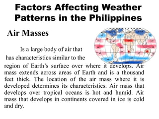
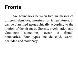
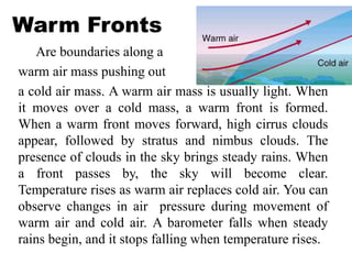
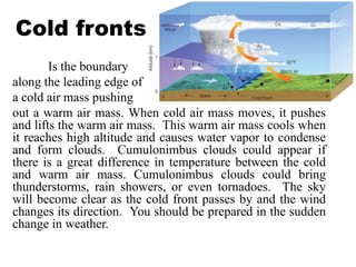
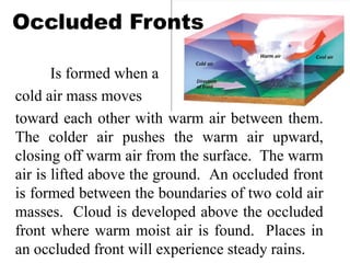
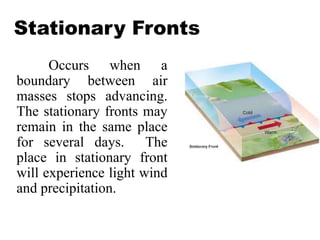
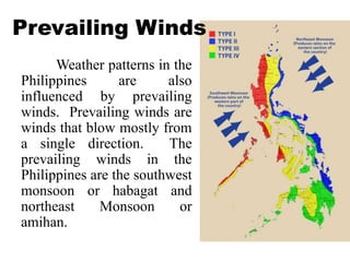
Weather patterns in the
Philippines are also
influenced by prevailing
winds. Prevailing winds are
winds that blow mostly from
a single direction. The
prevailing winds in the
Philippines are the southwest
monsoon or habagat and
northeast Monsoon or
amihan.
17. The southwest monsoon occurs from May to
October, and the northeast monsoon is from
November to early May. For most of the country,
the dry season is during amihan, and the wet season
is during habagat. The wet season starts in June and
reaches its peak in July and September. However,
weather patters change. Sometimes, rain arrives late
and lasts up to December. In some regions of the
Philippines, the seasons are different. Much of the
eastern seaboard, including Southern Leyte, Easter
Samar and Southeastern Luzon, the rain is from
December to March; and its fairly dry when the rest
of the country is raining.
18.
19. QUESTIONS
1. What are the four types of fronts in the country?
2. What is formed at the center of the most rapid
winds at the top of the troposphere?
3. What are the two prevailing winds in the
Philippines?
4. What are the most common precipitation types
in the Philippines?
5. What is the measure of the moisture present in
the air called?