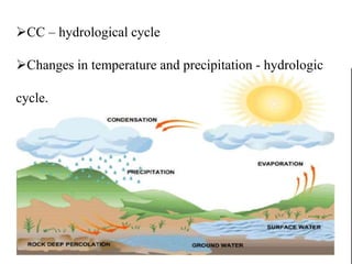
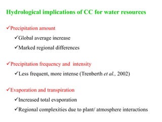
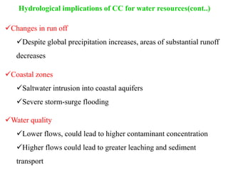
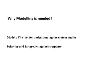
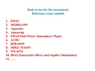
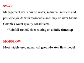
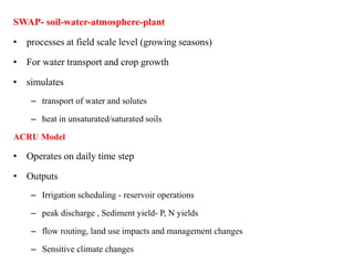
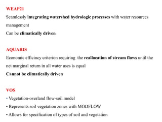
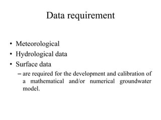
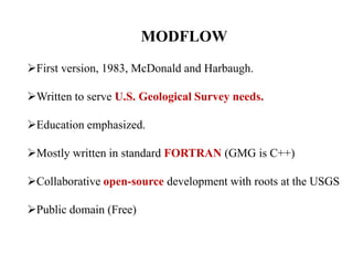
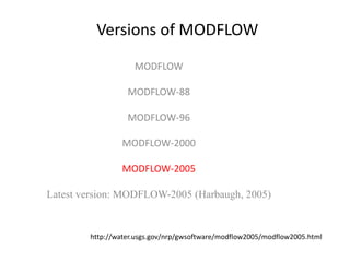
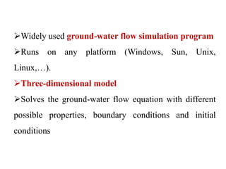
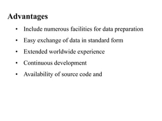
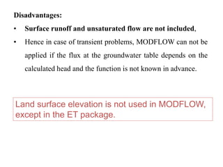
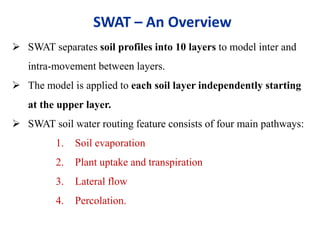
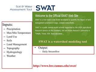
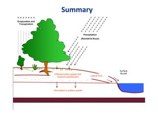
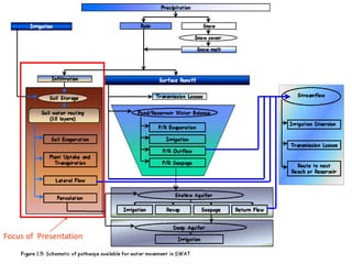
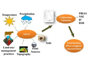
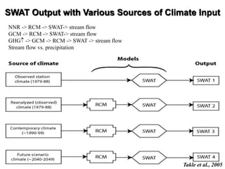
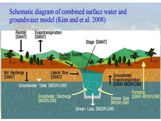
C.PRADIPA
M.Sc (Agrl. Meteorology)
CC – hydrological cycle
Changes in temperature and precipitation - hydrologic
cycle.
Hydrological implications of CC for water resources
Precipitation amount
Global average increase
Marked regional differences
Precipitation frequency and intensity
Less frequent, more intense (Trenberth et al., 2002)
Evaporation and transpiration
Increased total evaporation
Regional complexities due to plant/ atmosphere interactions
Hydrological implications of CC for water resources(cont..)
Changes in run off
Despite global precipitation increases, areas of substantial runoff
decreases
Coastal zones
Saltwater intrusion into coastal aquifers
Severe storm-surge flooding
Water quality
Lower flows, could lead to higher contaminant concentration
Higher flows could lead to greater leaching and sediment
transport
Why Modelling is needed?
Model : The tool for understanding the system and its
behavior and for predicting their response.
Tools to use for the assessment:
Reference water models
1. SWAT
2. MODFLOW
3. Aquarius
4. Aquacrop
5. SWAP (Soil Water Atmosphere Plant)
6. ACRU
7. RIBASIM
8. MIKE MASIN
9. WEAP21
10. IRAS (Interactive River and Aquifer Simulation)
11. . . .
SWAT:
Management decisions on water, sediment, nutrient and
pesticide yields with reasonable accuracy on river basins.
Complex water quality constituents
•Rainfall-runoff, river routing on a daily timestep
MODFLOW
Most widely used numerical groundwater flow model
SWAP- soil-water-atmosphere-plant
• processes at field scale level (growing seasons)
• For water transport and crop growth
• simulates
– transport of water and solutes
– heat in unsaturated/saturated soils
ACRU Model
• Operates on daily time step
• Outputs
– Irrigation scheduling - reservoir operations
– peak discharge , Sediment yield- P, N yields
– flow routing, land use impacts and management changes
– Sensitive climate changes
WEAP21
Seamlessly integrating watershed hydrologic processes with water resources
management
Can be climatically driven
AQUARIS
Economic efficincy criterion requiring the reallocation of stream flows until the
net marginal return in all water uses is equal
Cannot be climatically driven
VOS
• Vegetation-overland flow-soil model
• Represents soil vegetation zones with MODFLOW
• Allows for specification of types of soil and vegetation
Data requirement
• Meteorological
• Hydrological data
• Surface data
– are required for the development and calibration of
a mathematical and/or numerical groundwater
model.
MODFLOW
First version, 1983, McDonald and Harbaugh.
Written to serve U.S. Geological Survey needs.
Education emphasized.
Mostly written in standard FORTRAN (GMG is C++)
Collaborative open-source development with roots at the USGS
Public domain (Free)
Versions of MODFLOW
MODFLOW
MODFLOW-88
MODFLOW-96
MODFLOW-2000
MODFLOW-2005
Latest version: MODFLOW-2005 (Harbaugh, 2005)
http://water.usgs.gov/nrp/gwsoftware/modflow2005/modflow2005.html
Widely used ground-water flow simulation program
Runs on any platform (Windows, Sun, Unix,
Linux,…).
Three-dimensional model
Solves the ground-water flow equation with different
possible properties, boundary conditions and initial
conditions
Advantages
• Include numerous facilities for data preparation
• Easy exchange of data in standard form
• Extended worldwide experience
• Continuous development
• Availability of source code and
Disadvantages:
• Surface runoff and unsaturated flow are not included,
• Hence in case of transient problems, MODFLOW can not be
applied if the flux at the groundwater table depends on the
calculated head and the function is not known in advance.
Land surface elevation is not used in MODFLOW,
except in the ET package.
MODFLOW
• When properly applied, MODFLOW is the recognized
standard model.
• Ground-water flow within the aquifer is simulated in
MODFLOW using a block-centered finite-difference approach.
• Flows from external stresses such as flow to wells, areal
recharge, evapotranspiration, flow to drains, and flow through
riverbeds can also be simulated.
MODFLOW using a block-centered finite-difference
approach.
MT3D (A Modular 3D Solute Transport Model)
• simulating solute transport in complex hydrogeologic settings.
• MT3D is linked with MODFLOW
• Designed specifically to handle advectively-dominated
transport problems without the need to construct refined
models specifically for solute transport.
FEFLOW
(Finite Element Subsurface Flow System)
Finite-element package for simulating 3D and 2D fluid density-
coupled flow, contaminant mass (salinity) and heat transport in
the subsurface.
HST3D
(3-D Heat and Solute Transport Model)
simulates ground-water flow and associated heat and solute
transport in 3D.
SEAWAT
(Three-Dimensional Variable-Density Ground-Water Flow)
• Developed to simulate variable- density, transient ground-
water flow in porous media.
• The source code for SEAWAT was developed by combining
MODFLOW and MT3D into a single program that solves
the coupled flow and solute-transport equations.
• * MT3D -(A Modular 3D Solute Transport Model )
SUTRA
(2-D Saturated/Unsaturated Transport Model)
• A complete saltwater intrusion and energy transport model.
• A 3-D version of SUTRA has also been released.
SWIM
(Soil water infiltration and movement model)
• Deals with a one-dimensional vertical soil profile which
may be vertically in homogeneous but is assumed to be
horizontally uniform.
• Used to simulate runoff, infiltration, redistribution, solute
transport and redistribution of solutes, plant uptake and
transpiration, evaporation, deep drainage and leaching.
Often use MODFLOW through a
(Graphical) User Interface
Maps
Model
Results
MODFLOW – user perspective
•BASIC INPUT ITEMS:
•Grid
•Time stepping
•Solution parameters
•Hydraulic parameters (includes material properties)
•Boundary Conditions
•Stresses (source-sinks)
•Output options
•ASCII text files
OUTPUT OPTIONS
Listing file or into a separate file.
Complete listing of all input data, drawdown, and budget
data.
•Budget data are printed as a summary in the listing file,
and detailed budget data for all model cells can be written
into a separate file.
•ASCII text files
•Binary files
•Graphical user interface (GUI)
Case studies
•Projected impacts of climate change on farmers’ extraction of
groundwater from crystalline aquifers in South India
•Sylvain Ferrant et al., 2014
• Downscaled GCM data- spatially distributed agro-hydrological
model - MODFLOW
•Projected - climatic extremes create worse GWE shortages
•Areas vulnerable to CC in terms of irrigation apportionment
•Emphasize – importance of accounting for local characteristics
(water harvesting systems and maximal aquifer capacity versus
GWE) in developing measures to cope with CC impacts.
•Seasonal variation in natural recharge of coastal aquifers
•Mollema and Antonellini (2013)
•Temperature data for the period 1960–1990 from LocClim (local
climate estimator) and IPCC SRES A1b scenario
•For 2070–2100 - calculate the potential evapotranspiration with
the Thornthwaite method.
•Potential recharge (difference between precipitation and potential
evapotranspiration) was defined at 12 locations
• SEAWAT model
•Soil and Water Assessment Tool
• Spatial Scale: watershed or river basin
• Data Organization: sub basins or hydrologic response units
(HRU’s)
• Time scale: Continuous time model (long term yield model)
based on a daily scale
Not for a single event
• Data Inputs: weather, soil properties, topography,
vegetation, and land management practices
From the BASINS databases
SWAT – An Overview
 SWAT separates soil profiles into 10 layers to model inter and
intra-movement between layers.
 The model is applied to each soil layer independently starting
at the upper layer.
 SWAT soil water routing feature consists of four main pathways:
1. Soil evaporation
2. Plant uptake and transpiration
3. Lateral flow
4. Percolation.
SWAT – An Overview
Soil and Water Assessment
Tool (SWAT)
• Inputs:
– Precipitation
– Max/Min Temperature
– Land Use
– Soils
– Land Management
– Topography
– Hydrogeology
– Weather
http://www.brc.tamus.edu/swat/
• Output:
– Daily Streamflow
SWAT is a watershed modeling tool
Summary
Precipitation
(Rainfall & Snow)
Evaporation and
Transpiration
Infiltration/plant uptake/ Soil
moisture redistribution
Surface
Runoff
Lateral Flow
Percolation to shallow aquifer
Focus of Presentation
Land-use/
management
practices
SWAT
Topography
Soils
Temperature Precipitation
Calibration/
Validation
Prioritization
(Flow-weighted
concentration)
PBIAS
NSE
R2
RSR
Point
Sources
SWAT Output with Various Sources of Climate Input
Takle et al., 2005
NNR -> RCM -> SWAT-> stream flow
GCM -> RCM -> SWAT-> stream flow
GHG -> GCM -> RCM -> SWAT -> stream flow
Stream flow vs. precipitation
SWAT2000: current capabilities and research opportunities in applied
watershed modelling
J. G. Arnold and N. Fohrer, 2005
•To assist water resource managers in assessing the impact of management and
climate on water supplies and non-point source pollution in watersheds and large
river basins.
•Was developed to ‘scale up’ past field-scale models to large river basins.
•Model components include weather, hydrology, erosion/sedimentation, plant
growth, nutrients, pesticides, agricultural management, stream routing and
pond/reservoir routing.
•Current research is focusing on bacteria, riparian zones, pothole topography,
forest growth, channel downcutting and widening, and input uncertainty
analysis.
Climate change impact assessment on hydrology of Indian river basin
Gosain et al., 2006
• NATCOM - was the first attempt to quantify the impact of the climate change on the
water resources of the country
• twelve river basins
• detailed analyses on two river basins selected with respect to the extreme drought and
flood conditions predicted on account of the climate change.
• spatio-temporal water availability- without incorporating any man-made changes like
dams, diversions, etc.
Percent change in mean annual water balance components
Swat & modflow
Swat & modflow

Swat & modflow

  • 1.
  • 2.
    CC – hydrologicalcycle Changes in temperature and precipitation - hydrologic cycle.
  • 3.
    Hydrological implications ofCC for water resources Precipitation amount Global average increase Marked regional differences Precipitation frequency and intensity Less frequent, more intense (Trenberth et al., 2002) Evaporation and transpiration Increased total evaporation Regional complexities due to plant/ atmosphere interactions
  • 4.
    Hydrological implications ofCC for water resources(cont..) Changes in run off Despite global precipitation increases, areas of substantial runoff decreases Coastal zones Saltwater intrusion into coastal aquifers Severe storm-surge flooding Water quality Lower flows, could lead to higher contaminant concentration Higher flows could lead to greater leaching and sediment transport
  • 5.
    Why Modelling isneeded? Model : The tool for understanding the system and its behavior and for predicting their response.
  • 6.
    Tools to usefor the assessment: Reference water models 1. SWAT 2. MODFLOW 3. Aquarius 4. Aquacrop 5. SWAP (Soil Water Atmosphere Plant) 6. ACRU 7. RIBASIM 8. MIKE MASIN 9. WEAP21 10. IRAS (Interactive River and Aquifer Simulation) 11. . . .
  • 7.
    SWAT: Management decisions onwater, sediment, nutrient and pesticide yields with reasonable accuracy on river basins. Complex water quality constituents •Rainfall-runoff, river routing on a daily timestep MODFLOW Most widely used numerical groundwater flow model
  • 8.
    SWAP- soil-water-atmosphere-plant • processesat field scale level (growing seasons) • For water transport and crop growth • simulates – transport of water and solutes – heat in unsaturated/saturated soils ACRU Model • Operates on daily time step • Outputs – Irrigation scheduling - reservoir operations – peak discharge , Sediment yield- P, N yields – flow routing, land use impacts and management changes – Sensitive climate changes
  • 9.
    WEAP21 Seamlessly integrating watershedhydrologic processes with water resources management Can be climatically driven AQUARIS Economic efficincy criterion requiring the reallocation of stream flows until the net marginal return in all water uses is equal Cannot be climatically driven VOS • Vegetation-overland flow-soil model • Represents soil vegetation zones with MODFLOW • Allows for specification of types of soil and vegetation
  • 10.
    Data requirement • Meteorological •Hydrological data • Surface data – are required for the development and calibration of a mathematical and/or numerical groundwater model.
  • 11.
    MODFLOW First version, 1983,McDonald and Harbaugh. Written to serve U.S. Geological Survey needs. Education emphasized. Mostly written in standard FORTRAN (GMG is C++) Collaborative open-source development with roots at the USGS Public domain (Free)
  • 12.
    Versions of MODFLOW MODFLOW MODFLOW-88 MODFLOW-96 MODFLOW-2000 MODFLOW-2005 Latestversion: MODFLOW-2005 (Harbaugh, 2005) http://water.usgs.gov/nrp/gwsoftware/modflow2005/modflow2005.html
  • 13.
    Widely used ground-waterflow simulation program Runs on any platform (Windows, Sun, Unix, Linux,…). Three-dimensional model Solves the ground-water flow equation with different possible properties, boundary conditions and initial conditions
  • 14.
    Advantages • Include numerousfacilities for data preparation • Easy exchange of data in standard form • Extended worldwide experience • Continuous development • Availability of source code and
  • 15.
    Disadvantages: • Surface runoffand unsaturated flow are not included, • Hence in case of transient problems, MODFLOW can not be applied if the flux at the groundwater table depends on the calculated head and the function is not known in advance. Land surface elevation is not used in MODFLOW, except in the ET package.
  • 16.
    MODFLOW • When properlyapplied, MODFLOW is the recognized standard model. • Ground-water flow within the aquifer is simulated in MODFLOW using a block-centered finite-difference approach. • Flows from external stresses such as flow to wells, areal recharge, evapotranspiration, flow to drains, and flow through riverbeds can also be simulated.
  • 17.
    MODFLOW using ablock-centered finite-difference approach.
  • 18.
    MT3D (A Modular3D Solute Transport Model) • simulating solute transport in complex hydrogeologic settings. • MT3D is linked with MODFLOW • Designed specifically to handle advectively-dominated transport problems without the need to construct refined models specifically for solute transport.
  • 19.
    FEFLOW (Finite Element SubsurfaceFlow System) Finite-element package for simulating 3D and 2D fluid density- coupled flow, contaminant mass (salinity) and heat transport in the subsurface. HST3D (3-D Heat and Solute Transport Model) simulates ground-water flow and associated heat and solute transport in 3D.
  • 20.
    SEAWAT (Three-Dimensional Variable-Density Ground-WaterFlow) • Developed to simulate variable- density, transient ground- water flow in porous media. • The source code for SEAWAT was developed by combining MODFLOW and MT3D into a single program that solves the coupled flow and solute-transport equations. • * MT3D -(A Modular 3D Solute Transport Model )
  • 21.
    SUTRA (2-D Saturated/Unsaturated TransportModel) • A complete saltwater intrusion and energy transport model. • A 3-D version of SUTRA has also been released.
  • 22.
    SWIM (Soil water infiltrationand movement model) • Deals with a one-dimensional vertical soil profile which may be vertically in homogeneous but is assumed to be horizontally uniform. • Used to simulate runoff, infiltration, redistribution, solute transport and redistribution of solutes, plant uptake and transpiration, evaporation, deep drainage and leaching.
  • 23.
    Often use MODFLOWthrough a (Graphical) User Interface Maps Model Results
  • 24.
    MODFLOW – userperspective
  • 25.
    •BASIC INPUT ITEMS: •Grid •Timestepping •Solution parameters •Hydraulic parameters (includes material properties) •Boundary Conditions •Stresses (source-sinks) •Output options •ASCII text files
  • 26.
    OUTPUT OPTIONS Listing fileor into a separate file. Complete listing of all input data, drawdown, and budget data. •Budget data are printed as a summary in the listing file, and detailed budget data for all model cells can be written into a separate file. •ASCII text files •Binary files •Graphical user interface (GUI)
  • 27.
  • 28.
    •Projected impacts ofclimate change on farmers’ extraction of groundwater from crystalline aquifers in South India •Sylvain Ferrant et al., 2014 • Downscaled GCM data- spatially distributed agro-hydrological model - MODFLOW •Projected - climatic extremes create worse GWE shortages •Areas vulnerable to CC in terms of irrigation apportionment •Emphasize – importance of accounting for local characteristics (water harvesting systems and maximal aquifer capacity versus GWE) in developing measures to cope with CC impacts.
  • 29.
    •Seasonal variation innatural recharge of coastal aquifers •Mollema and Antonellini (2013) •Temperature data for the period 1960–1990 from LocClim (local climate estimator) and IPCC SRES A1b scenario •For 2070–2100 - calculate the potential evapotranspiration with the Thornthwaite method. •Potential recharge (difference between precipitation and potential evapotranspiration) was defined at 12 locations • SEAWAT model
  • 31.
    •Soil and WaterAssessment Tool • Spatial Scale: watershed or river basin • Data Organization: sub basins or hydrologic response units (HRU’s) • Time scale: Continuous time model (long term yield model) based on a daily scale Not for a single event • Data Inputs: weather, soil properties, topography, vegetation, and land management practices From the BASINS databases SWAT – An Overview
  • 32.
     SWAT separatessoil profiles into 10 layers to model inter and intra-movement between layers.  The model is applied to each soil layer independently starting at the upper layer.  SWAT soil water routing feature consists of four main pathways: 1. Soil evaporation 2. Plant uptake and transpiration 3. Lateral flow 4. Percolation. SWAT – An Overview
  • 33.
    Soil and WaterAssessment Tool (SWAT) • Inputs: – Precipitation – Max/Min Temperature – Land Use – Soils – Land Management – Topography – Hydrogeology – Weather http://www.brc.tamus.edu/swat/ • Output: – Daily Streamflow SWAT is a watershed modeling tool
  • 34.
    Summary Precipitation (Rainfall & Snow) Evaporationand Transpiration Infiltration/plant uptake/ Soil moisture redistribution Surface Runoff Lateral Flow Percolation to shallow aquifer
  • 35.
  • 36.
  • 37.
    SWAT Output withVarious Sources of Climate Input Takle et al., 2005 NNR -> RCM -> SWAT-> stream flow GCM -> RCM -> SWAT-> stream flow GHG -> GCM -> RCM -> SWAT -> stream flow Stream flow vs. precipitation
  • 38.
    SWAT2000: current capabilitiesand research opportunities in applied watershed modelling J. G. Arnold and N. Fohrer, 2005 •To assist water resource managers in assessing the impact of management and climate on water supplies and non-point source pollution in watersheds and large river basins. •Was developed to ‘scale up’ past field-scale models to large river basins. •Model components include weather, hydrology, erosion/sedimentation, plant growth, nutrients, pesticides, agricultural management, stream routing and pond/reservoir routing. •Current research is focusing on bacteria, riparian zones, pothole topography, forest growth, channel downcutting and widening, and input uncertainty analysis.
  • 39.
    Climate change impactassessment on hydrology of Indian river basin Gosain et al., 2006 • NATCOM - was the first attempt to quantify the impact of the climate change on the water resources of the country • twelve river basins • detailed analyses on two river basins selected with respect to the extreme drought and flood conditions predicted on account of the climate change. • spatio-temporal water availability- without incorporating any man-made changes like dams, diversions, etc. Percent change in mean annual water balance components

Editor's Notes