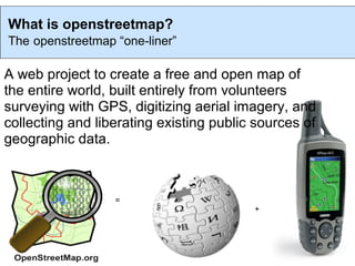
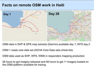
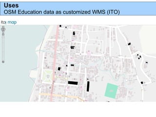
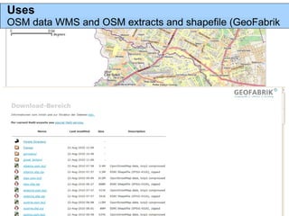
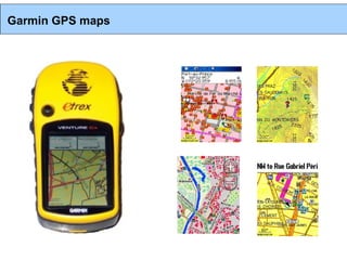
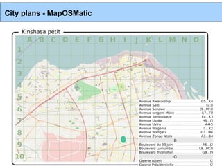
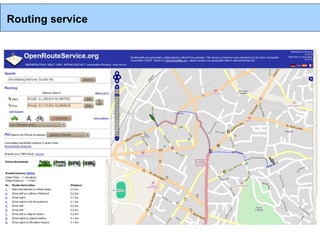
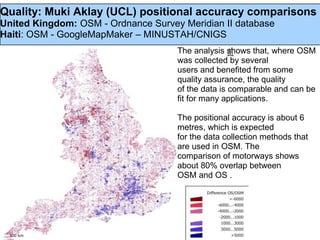
SlideShare a Scribd company logo
1 of 40
Mapping education features in Haiti

Contributions from the experience of the OSM project

                 PAP, Feb 2012
What is openstreetmap?
The openstreetmap “one-liner”

A web project to create a free and open map of
the entire world, built entirely from volunteers
surveying with GPS, digitizing aerial imagery, and
collecting and liberating existing public sources of
geographic data.


                  =
                                         +
Facts on remote OSM work in Haiti

Day 1                                  Day 28


OSM data in SHP & GPS map extracts (Garmin) available day 1; WFS day 2

OSM = roads core data set (OCHA Core Data sets check-list).

OSM data used as SHP, WFS, WMS in responders mapping production

26 hours to get imagery released and 48 hours to get 1st imagery loaded on
the OSM platform available for tracing
HOT Missions facts

 Hundreds trainees
 UN Cluster System - GoH - Civil Society
 Pap, Jacmel, Leogane & Gonaives
 Train the trainers schemes involving Haitian mappers
 Training package
 Support

 June 2010: IOM actively using OSM and hiring Haitian trainees

 Aug 2010: creation of the Communaute OpenStreetMap Haiti
 (COSMHA) from past trainees working from IOM
HOT support to IOM May/August – April 2011

 Mapping
 Baseline (transportation - street name)
 Infra-camp features
 Humanitarian baselines: cholera & disaster risk management (hurricane
 shelters)

 Capacity building
 Creation of a mapping team made of COSMHA mappers Cite Soleil
 Support to OSM mappers in IOM
 Train IOM staffs and partners in UN-GoH-Civil Society in Survey and
 OSM

 Geographic span
 4 mapping teams In Pap, Leogane, Jacmel and Gonaives
OSM ecosystem in Haiti Jan 2012
DRR & Baseline mapping with IOM
IOM-GIS unit partnership with Coopi/IRD
* 20 mappers from COSMHA
* International support/ set-up by HOT
DRR & baseline mapping
Port Au Prince : quake affected metropolitan areas
April 2011 → April/May 2012

Mapping the Saint-Marc Development Corridor
USAID/OTI/HRI & COSMHA/HOT
1 HOT (volunteership/ internship) & 9 COSMHA to train 30 Youths
Training & baseline survey/ mapping
Create a COSMHA-SaintMarc
Jan-April 2012

Haitidata.org
Advisory mission on haitidata and use of OSM in DRR perspective
Data upload
Advising/ set up role to use OSM to map Haiti within a DRR perspective

Projects in design
Education, health...
OSM ecosystem in Haiti Jan 2012
Soley leve
Mapping component of a voluntary community lead project in Cite Soleil.

TapTapMap.org
Voluntary mapping of public/private transportation lines in Pap and Haiti

Education & training
Haiti Communitere (HC)
Ecole Superieure d'Infotronique d'Haiti (ESIH)

OSM in Business
Maps
GPS maps
Apps around Androids/Tablets.
free and open voluntary map of the
Voluntary, individual open contributions under
   world. open contribution. open use.
open licence (OdbL), open use
WORKFLOW
Wiki
OSM-Quality Assurance
Tasking server
Tasking server
Tasking server - JOSM
Tasking server – walking paper
Direct measurements: walking papers
                      Combined, GPS and Walking Papers
                      can be used for rapid surveying and
                      ground truthing.

                      Walking Papers allow users to print out
                      small sections of the OSM map. In the
                      field, these paper maps can be used to
                      draw new features, annotate existing
                      data, and take notes that will help with
                      the import of GPS data.

                      Icons in each of the corners and a
                      unique code for each Walking Paper let
                      users scan the paper and upload to
                      OSM so the notes can be viewed in an
                      editing environment.

                      http://walking-papers.org
Preparing Survey
Support materials
HOT Hardware kit, / OSM Kit / Guides
Direct measurements: Questionnaires.
Based on OSM Humanitarian Data Model (HDM)
Map Features
Semantic interoperability
Humanitarian Data Model
Semantic interoperability
Surveying
Editing the OSM database with JOSM
JOSM
JOSM - history
Mapper
JOSM - validation
OSM Inspector - Validation
KeepRight - Validation
TagInfo - Tag Validation
TagWatch - Tag Validation
Documentation
Wiki
Guides
Tutorials
Developments
Imports
Mapping projects
…
Uses
OSM Education data as customized WMS (ITO)
Uses
OSM data WMS and OSM extracts and shapefile (GeoFabrik
Garmin GPS maps
City plans - MapOSMatic
Routing service
Quality: Muki Aklay (UCL) positional accuracy comparisons
United Kingdom: OSM - Ordnance Survey Meridian II database
Haiti: OSM - GoogleMapMaker – MINUSTAH/CNIGS
                                     The analysis shows that, where OSM
                                     was collected by several
                                     users and benefited from some
                                     quality assurance, the quality
                                     of the data is comparable and can be
                                     fit for many applications.

                                     The positional accuracy is about 6
                                     metres, which is expected
                                     for the data collection methods that
                                     are used in OSM. The
                                     comparison of motorways shows
                                     about 80% overlap between
                                     OSM and OS .
http://wiki.openstreetmap.org/wiki/Humanitarian_OSM_
Team
http://hot.openstreetmap.org/weblog/


hot@openstreetmap.org
Talk-ht@openstreetmap.org


nicolas.chavent@hotosm.org
hotosm@gmail.com

More Related Content

What's hot

OpenStreetMap, an introduction
OpenStreetMap, an introductionOpenStreetMap, an introduction
OpenStreetMap, an introductionFrédéric Rodrigo
 
H.O.T at UNGIWG 10
H.O.T at UNGIWG 10H.O.T at UNGIWG 10
H.O.T at UNGIWG 10mikel_maron
 
Openstreetmap and its value during emergencies
Openstreetmap and its value during emergenciesOpenstreetmap and its value during emergencies
Openstreetmap and its value during emergenciesErvin Malicdem
 
Introduction to OpenStreetMap, its extracts, and relation to Project NOAH
Introduction to OpenStreetMap, its extracts, and relation to Project NOAHIntroduction to OpenStreetMap, its extracts, and relation to Project NOAH
Introduction to OpenStreetMap, its extracts, and relation to Project NOAHErvin Malicdem
 
Haiti Qake2010 Bar Camp Canberra2010
Haiti Qake2010 Bar Camp Canberra2010Haiti Qake2010 Bar Camp Canberra2010
Haiti Qake2010 Bar Camp Canberra2010Shoaib Burq
 
OpenStreetMap at Camp Roberts
OpenStreetMap at Camp RobertsOpenStreetMap at Camp Roberts
OpenStreetMap at Camp Robertsmikel_maron
 
Map Kibera at the UN
Map Kibera at the UNMap Kibera at the UN
Map Kibera at the UNmikel_maron
 
OpenStreetMap at Wikimania
OpenStreetMap at WikimaniaOpenStreetMap at Wikimania
OpenStreetMap at Wikimaniamikel_maron
 
OpenMappingAfrica
OpenMappingAfricaOpenMappingAfrica
OpenMappingAfricamikel_maron
 
GeOng presentation about OpenStreetMap
GeOng presentation about OpenStreetMapGeOng presentation about OpenStreetMap
GeOng presentation about OpenStreetMapchippy
 
Crowdsourced mapping for open collaboration: A story of Taiwan so far
Crowdsourced mapping for open collaboration: A story of Taiwan so farCrowdsourced mapping for open collaboration: A story of Taiwan so far
Crowdsourced mapping for open collaboration: A story of Taiwan so farDongpo Deng
 
shift2010 - 17apr2010 - OpenStreetMap: a free map for our world
shift2010 - 17apr2010 - OpenStreetMap: a free map for our worldshift2010 - 17apr2010 - OpenStreetMap: a free map for our world
shift2010 - 17apr2010 - OpenStreetMap: a free map for our worldSimone Cortesi
 
Ieee 2014 tech_training_open_streetmap_20121011
Ieee 2014 tech_training_open_streetmap_20121011Ieee 2014 tech_training_open_streetmap_20121011
Ieee 2014 tech_training_open_streetmap_20121011ALCE Samuel Paul
 
Spatial Information and Bicycling Safety
Spatial Information and Bicycling SafetySpatial Information and Bicycling Safety
Spatial Information and Bicycling SafetyMartin L
 
FreeMap Palestine November 2008
FreeMap Palestine November 2008FreeMap Palestine November 2008
FreeMap Palestine November 2008mikel_maron
 
Participatory mapping with OSM in Ulan Bator, Mongolia: general presentation ...
Participatory mapping with OSM in Ulan Bator, Mongolia: general presentation ...Participatory mapping with OSM in Ulan Bator, Mongolia: general presentation ...
Participatory mapping with OSM in Ulan Bator, Mongolia: general presentation ...Severin Menard
 
Spatial Information for Bicycling Research
Spatial Information for Bicycling ResearchSpatial Information for Bicycling Research
Spatial Information for Bicycling ResearchMartin L
 
A very high resolution bicycle flow model
A very high resolution bicycle flow modelA very high resolution bicycle flow model
A very high resolution bicycle flow modelMartin L
 

What's hot (20)

OpenStreetMap, an introduction
OpenStreetMap, an introductionOpenStreetMap, an introduction
OpenStreetMap, an introduction
 
H.O.T at UNGIWG 10
H.O.T at UNGIWG 10H.O.T at UNGIWG 10
H.O.T at UNGIWG 10
 
Openstreetmap and its value during emergencies
Openstreetmap and its value during emergenciesOpenstreetmap and its value during emergencies
Openstreetmap and its value during emergencies
 
Introduction to OpenStreetMap, its extracts, and relation to Project NOAH
Introduction to OpenStreetMap, its extracts, and relation to Project NOAHIntroduction to OpenStreetMap, its extracts, and relation to Project NOAH
Introduction to OpenStreetMap, its extracts, and relation to Project NOAH
 
20150317CIU2015seto
20150317CIU2015seto20150317CIU2015seto
20150317CIU2015seto
 
Haiti Qake2010 Bar Camp Canberra2010
Haiti Qake2010 Bar Camp Canberra2010Haiti Qake2010 Bar Camp Canberra2010
Haiti Qake2010 Bar Camp Canberra2010
 
OpenStreetMap at Camp Roberts
OpenStreetMap at Camp RobertsOpenStreetMap at Camp Roberts
OpenStreetMap at Camp Roberts
 
Map Kibera at the UN
Map Kibera at the UNMap Kibera at the UN
Map Kibera at the UN
 
OpenStreetMap at Wikimania
OpenStreetMap at WikimaniaOpenStreetMap at Wikimania
OpenStreetMap at Wikimania
 
OpenMappingAfrica
OpenMappingAfricaOpenMappingAfrica
OpenMappingAfrica
 
GeOng presentation about OpenStreetMap
GeOng presentation about OpenStreetMapGeOng presentation about OpenStreetMap
GeOng presentation about OpenStreetMap
 
Crowdsourced mapping for open collaboration: A story of Taiwan so far
Crowdsourced mapping for open collaboration: A story of Taiwan so farCrowdsourced mapping for open collaboration: A story of Taiwan so far
Crowdsourced mapping for open collaboration: A story of Taiwan so far
 
shift2010 - 17apr2010 - OpenStreetMap: a free map for our world
shift2010 - 17apr2010 - OpenStreetMap: a free map for our worldshift2010 - 17apr2010 - OpenStreetMap: a free map for our world
shift2010 - 17apr2010 - OpenStreetMap: a free map for our world
 
Ieee 2014 tech_training_open_streetmap_20121011
Ieee 2014 tech_training_open_streetmap_20121011Ieee 2014 tech_training_open_streetmap_20121011
Ieee 2014 tech_training_open_streetmap_20121011
 
Spatial Information and Bicycling Safety
Spatial Information and Bicycling SafetySpatial Information and Bicycling Safety
Spatial Information and Bicycling Safety
 
FreeMap Palestine November 2008
FreeMap Palestine November 2008FreeMap Palestine November 2008
FreeMap Palestine November 2008
 
Participatory mapping with OSM in Ulan Bator, Mongolia: general presentation ...
Participatory mapping with OSM in Ulan Bator, Mongolia: general presentation ...Participatory mapping with OSM in Ulan Bator, Mongolia: general presentation ...
Participatory mapping with OSM in Ulan Bator, Mongolia: general presentation ...
 
Spatial Information for Bicycling Research
Spatial Information for Bicycling ResearchSpatial Information for Bicycling Research
Spatial Information for Bicycling Research
 
A very high resolution bicycle flow model
A very high resolution bicycle flow modelA very high resolution bicycle flow model
A very high resolution bicycle flow model
 
Osm Presentation
Osm PresentationOsm Presentation
Osm Presentation
 

Viewers also liked

регистрация компаний на Кипре
регистрация компаний на Кипререгистрация компаний на Кипре
регистрация компаний на КипреBridgeWest.eu
 
регистрация компаний в Чехии
регистрация компаний в Чехиирегистрация компаний в Чехии
регистрация компаний в ЧехииBridgeWest.eu
 
Best Use of Social Media in Education : Joint Initiative by NVS and Intel
Best Use of Social Media in Education : Joint Initiative by NVS and IntelBest Use of Social Media in Education : Joint Initiative by NVS and Intel
Best Use of Social Media in Education : Joint Initiative by NVS and IntelSheeza Muzaffar
 
Global tobacco epidemic through the European lens
Global tobacco epidemic through the European lensGlobal tobacco epidemic through the European lens
Global tobacco epidemic through the European lensUCT ICO
 
97志工服務經驗分享
97志工服務經驗分享97志工服務經驗分享
97志工服務經驗分享mrJim Note
 
Customer Bulletin 05-15 A Comparison of ISO-C1 and HT-300 Polyisocyanurate In...
Customer Bulletin 05-15 A Comparison of ISO-C1 and HT-300 Polyisocyanurate In...Customer Bulletin 05-15 A Comparison of ISO-C1 and HT-300 Polyisocyanurate In...
Customer Bulletin 05-15 A Comparison of ISO-C1 and HT-300 Polyisocyanurate In...Joe Hughes
 
Cheese Unit Day 2 August 16
Cheese Unit Day 2 August 16Cheese Unit Day 2 August 16
Cheese Unit Day 2 August 16Rachael Mann
 
ретаргетинг
ретаргетингретаргетинг
ретаргетингNikita Sawinyh
 
Is the world achieving the 2025 target on tobacco use?
Is the world achieving the 2025 target on tobacco use?Is the world achieving the 2025 target on tobacco use?
Is the world achieving the 2025 target on tobacco use?UCT ICO
 
ยีนและโครโมโซม
ยีนและโครโมโซมยีนและโครโมโซม
ยีนและโครโมโซมBiobiome
 
Social media + Local Search - Liana Evans- Digitizing
Social media + Local Search - Liana Evans- DigitizingSocial media + Local Search - Liana Evans- Digitizing
Social media + Local Search - Liana Evans- Digitizingel_chambers
 

Viewers also liked (19)

Lawyers Greece
Lawyers GreeceLawyers Greece
Lawyers Greece
 
Surgem anjos
Surgem anjosSurgem anjos
Surgem anjos
 
регистрация компаний на Кипре
регистрация компаний на Кипререгистрация компаний на Кипре
регистрация компаний на Кипре
 
регистрация компаний в Чехии
регистрация компаний в Чехиирегистрация компаний в Чехии
регистрация компаний в Чехии
 
Best Use of Social Media in Education : Joint Initiative by NVS and Intel
Best Use of Social Media in Education : Joint Initiative by NVS and IntelBest Use of Social Media in Education : Joint Initiative by NVS and Intel
Best Use of Social Media in Education : Joint Initiative by NVS and Intel
 
Happiners 201502 영업방향 및 상품전략
Happiners 201502 영업방향 및 상품전략Happiners 201502 영업방향 및 상품전략
Happiners 201502 영업방향 및 상품전략
 
Genetics
GeneticsGenetics
Genetics
 
Global tobacco epidemic through the European lens
Global tobacco epidemic through the European lensGlobal tobacco epidemic through the European lens
Global tobacco epidemic through the European lens
 
Little Penguins
Little PenguinsLittle Penguins
Little Penguins
 
Lt
LtLt
Lt
 
Eu future tense
Eu future tenseEu future tense
Eu future tense
 
97志工服務經驗分享
97志工服務經驗分享97志工服務經驗分享
97志工服務經驗分享
 
Customer Bulletin 05-15 A Comparison of ISO-C1 and HT-300 Polyisocyanurate In...
Customer Bulletin 05-15 A Comparison of ISO-C1 and HT-300 Polyisocyanurate In...Customer Bulletin 05-15 A Comparison of ISO-C1 and HT-300 Polyisocyanurate In...
Customer Bulletin 05-15 A Comparison of ISO-C1 and HT-300 Polyisocyanurate In...
 
Cheese Unit Day 2 August 16
Cheese Unit Day 2 August 16Cheese Unit Day 2 August 16
Cheese Unit Day 2 August 16
 
ретаргетинг
ретаргетингретаргетинг
ретаргетинг
 
Is the world achieving the 2025 target on tobacco use?
Is the world achieving the 2025 target on tobacco use?Is the world achieving the 2025 target on tobacco use?
Is the world achieving the 2025 target on tobacco use?
 
Science50
Science50Science50
Science50
 
ยีนและโครโมโซม
ยีนและโครโมโซมยีนและโครโมโซม
ยีนและโครโมโซม
 
Social media + Local Search - Liana Evans- Digitizing
Social media + Local Search - Liana Evans- DigitizingSocial media + Local Search - Liana Evans- Digitizing
Social media + Local Search - Liana Evans- Digitizing
 

Similar to Haiti HOT OSM éducation 15/02/2012 (FR)

Humanitarian OpenStreetMap Team [H.O.T.] Training for SBTF
Humanitarian OpenStreetMap Team [H.O.T.] Training for SBTFHumanitarian OpenStreetMap Team [H.O.T.] Training for SBTF
Humanitarian OpenStreetMap Team [H.O.T.] Training for SBTFStandby Task Force
 
OpenStreetMap and CycleStreets: collaborative map-making and cartography in t...
OpenStreetMap and CycleStreets: collaborative map-making and cartography in t...OpenStreetMap and CycleStreets: collaborative map-making and cartography in t...
OpenStreetMap and CycleStreets: collaborative map-making and cartography in t...CycleStreets
 
Osm application
Osm applicationOsm application
Osm applicationQust04
 
Introduction to OpenStreetMap and Humanitarian OSM Team for Plan Internationa...
Introduction to OpenStreetMap and Humanitarian OSM Team for Plan Internationa...Introduction to OpenStreetMap and Humanitarian OSM Team for Plan Internationa...
Introduction to OpenStreetMap and Humanitarian OSM Team for Plan Internationa...chippy
 
[Day 3] Agcommons Quickwin: gRoads
[Day 3] Agcommons Quickwin: gRoads[Day 3] Agcommons Quickwin: gRoads
[Day 3] Agcommons Quickwin: gRoadscsi2009
 
OpenStreetMap - The Quality Issue
OpenStreetMap - The Quality IssueOpenStreetMap - The Quality Issue
OpenStreetMap - The Quality IssueCASA, UCL
 
OpenStreetMap Presentation to Fairfax Advocates for Better Bicycling: How OSM...
OpenStreetMap Presentation to Fairfax Advocates for Better Bicycling: How OSM...OpenStreetMap Presentation to Fairfax Advocates for Better Bicycling: How OSM...
OpenStreetMap Presentation to Fairfax Advocates for Better Bicycling: How OSM...Josh Doe
 
OpenStreetMap-Introduction
OpenStreetMap-IntroductionOpenStreetMap-Introduction
OpenStreetMap-IntroductionPhilippe Rieffel
 
II-SDV 2015, 21 - 21 April, in Nice
II-SDV 2015, 21 - 21 April, in NiceII-SDV 2015, 21 - 21 April, in Nice
II-SDV 2015, 21 - 21 April, in NiceDr. Haxel Consult
 
GRASS and OSGeo: a framework for archeology
GRASS and OSGeo: a framework for archeologyGRASS and OSGeo: a framework for archeology
GRASS and OSGeo: a framework for archeologyMarkus Neteler
 
Predictive geospatial analytics using principal component regression
Predictive geospatial analytics using principal component regression Predictive geospatial analytics using principal component regression
Predictive geospatial analytics using principal component regression IJECEIAES
 
Talk: "Using Open Data and Crowdsourcing to develop CycleStreets"
Talk: "Using Open Data and Crowdsourcing to develop CycleStreets"Talk: "Using Open Data and Crowdsourcing to develop CycleStreets"
Talk: "Using Open Data and Crowdsourcing to develop CycleStreets"CycleStreets
 
Openstreetmap presentation of Mapping Party at FSMK camp
Openstreetmap presentation of Mapping Party at FSMK campOpenstreetmap presentation of Mapping Party at FSMK camp
Openstreetmap presentation of Mapping Party at FSMK campYogesh Ks
 
Volunteered Geographic Information and OpenStreetMap
Volunteered Geographic Information and OpenStreetMapVolunteered Geographic Information and OpenStreetMap
Volunteered Geographic Information and OpenStreetMapchippy
 
OpenStreetMap Past, Present and Future
OpenStreetMap Past, Present and FutureOpenStreetMap Past, Present and Future
OpenStreetMap Past, Present and FuturePeter Batty
 
APPLICABILITY OF CROWD SOURCING TO DETERMINE THE BEST TRANSPORTATION METHOD B...
APPLICABILITY OF CROWD SOURCING TO DETERMINE THE BEST TRANSPORTATION METHOD B...APPLICABILITY OF CROWD SOURCING TO DETERMINE THE BEST TRANSPORTATION METHOD B...
APPLICABILITY OF CROWD SOURCING TO DETERMINE THE BEST TRANSPORTATION METHOD B...IJDKP
 
OSM Philippines presentation
OSM Philippines presentationOSM Philippines presentation
OSM Philippines presentationesambale
 
From a niche to a global user community: Open Source GIS and OSGeo
From a niche to a global user community: Open Source GIS and OSGeoFrom a niche to a global user community: Open Source GIS and OSGeo
From a niche to a global user community: Open Source GIS and OSGeoMarkus Neteler
 

Similar to Haiti HOT OSM éducation 15/02/2012 (FR) (20)

Humanitarian OpenStreetMap Team [H.O.T.] Training for SBTF
Humanitarian OpenStreetMap Team [H.O.T.] Training for SBTFHumanitarian OpenStreetMap Team [H.O.T.] Training for SBTF
Humanitarian OpenStreetMap Team [H.O.T.] Training for SBTF
 
OpenStreetMap and CycleStreets: collaborative map-making and cartography in t...
OpenStreetMap and CycleStreets: collaborative map-making and cartography in t...OpenStreetMap and CycleStreets: collaborative map-making and cartography in t...
OpenStreetMap and CycleStreets: collaborative map-making and cartography in t...
 
Osm application
Osm applicationOsm application
Osm application
 
Introduction to OpenStreetMap and Humanitarian OSM Team for Plan Internationa...
Introduction to OpenStreetMap and Humanitarian OSM Team for Plan Internationa...Introduction to OpenStreetMap and Humanitarian OSM Team for Plan Internationa...
Introduction to OpenStreetMap and Humanitarian OSM Team for Plan Internationa...
 
[Day 3] Agcommons Quickwin: gRoads
[Day 3] Agcommons Quickwin: gRoads[Day 3] Agcommons Quickwin: gRoads
[Day 3] Agcommons Quickwin: gRoads
 
AAG panel discussion on great lakes africa
AAG panel discussion on great lakes africaAAG panel discussion on great lakes africa
AAG panel discussion on great lakes africa
 
OpenStreetMap - The Quality Issue
OpenStreetMap - The Quality IssueOpenStreetMap - The Quality Issue
OpenStreetMap - The Quality Issue
 
OpenStreetMap Presentation to Fairfax Advocates for Better Bicycling: How OSM...
OpenStreetMap Presentation to Fairfax Advocates for Better Bicycling: How OSM...OpenStreetMap Presentation to Fairfax Advocates for Better Bicycling: How OSM...
OpenStreetMap Presentation to Fairfax Advocates for Better Bicycling: How OSM...
 
OpenStreetMap-Introduction
OpenStreetMap-IntroductionOpenStreetMap-Introduction
OpenStreetMap-Introduction
 
II-SDV 2015, 21 - 21 April, in Nice
II-SDV 2015, 21 - 21 April, in NiceII-SDV 2015, 21 - 21 April, in Nice
II-SDV 2015, 21 - 21 April, in Nice
 
GRASS and OSGeo: a framework for archeology
GRASS and OSGeo: a framework for archeologyGRASS and OSGeo: a framework for archeology
GRASS and OSGeo: a framework for archeology
 
Predictive geospatial analytics using principal component regression
Predictive geospatial analytics using principal component regression Predictive geospatial analytics using principal component regression
Predictive geospatial analytics using principal component regression
 
Talk: "Using Open Data and Crowdsourcing to develop CycleStreets"
Talk: "Using Open Data and Crowdsourcing to develop CycleStreets"Talk: "Using Open Data and Crowdsourcing to develop CycleStreets"
Talk: "Using Open Data and Crowdsourcing to develop CycleStreets"
 
Openstreetmap presentation of Mapping Party at FSMK camp
Openstreetmap presentation of Mapping Party at FSMK campOpenstreetmap presentation of Mapping Party at FSMK camp
Openstreetmap presentation of Mapping Party at FSMK camp
 
Volunteered Geographic Information and OpenStreetMap
Volunteered Geographic Information and OpenStreetMapVolunteered Geographic Information and OpenStreetMap
Volunteered Geographic Information and OpenStreetMap
 
OpenStreetMap Past, Present and Future
OpenStreetMap Past, Present and FutureOpenStreetMap Past, Present and Future
OpenStreetMap Past, Present and Future
 
APPLICABILITY OF CROWD SOURCING TO DETERMINE THE BEST TRANSPORTATION METHOD B...
APPLICABILITY OF CROWD SOURCING TO DETERMINE THE BEST TRANSPORTATION METHOD B...APPLICABILITY OF CROWD SOURCING TO DETERMINE THE BEST TRANSPORTATION METHOD B...
APPLICABILITY OF CROWD SOURCING TO DETERMINE THE BEST TRANSPORTATION METHOD B...
 
APPLICABILITY OF CROWD SOURCING TO DETERMINE THE BEST TRANSPORTATION METHOD B...
APPLICABILITY OF CROWD SOURCING TO DETERMINE THE BEST TRANSPORTATION METHOD B...APPLICABILITY OF CROWD SOURCING TO DETERMINE THE BEST TRANSPORTATION METHOD B...
APPLICABILITY OF CROWD SOURCING TO DETERMINE THE BEST TRANSPORTATION METHOD B...
 
OSM Philippines presentation
OSM Philippines presentationOSM Philippines presentation
OSM Philippines presentation
 
From a niche to a global user community: Open Source GIS and OSGeo
From a niche to a global user community: Open Source GIS and OSGeoFrom a niche to a global user community: Open Source GIS and OSGeo
From a niche to a global user community: Open Source GIS and OSGeo
 

More from Severin Menard

OpenStreetMap - La carte libre du monde
OpenStreetMap - La carte libre du mondeOpenStreetMap - La carte libre du monde
OpenStreetMap - La carte libre du mondeSeverin Menard
 
Open data e OpenStreetMap
Open data e OpenStreetMapOpen data e OpenStreetMap
Open data e OpenStreetMapSeverin Menard
 
OpenStreetMap : la carte libre du monde
OpenStreetMap : la carte libre du mondeOpenStreetMap : la carte libre du monde
OpenStreetMap : la carte libre du mondeSeverin Menard
 
OpenStreetMap : um mapa wiki mundial livre
OpenStreetMap : um mapa wiki mundial livreOpenStreetMap : um mapa wiki mundial livre
OpenStreetMap : um mapa wiki mundial livreSeverin Menard
 
Cartographie systématique dans OSM avec un référentiel routier
Cartographie systématique dans OSM  avec un référentiel routierCartographie systématique dans OSM  avec un référentiel routier
Cartographie systématique dans OSM avec un référentiel routierSeverin Menard
 
GIS based flood risk assessment exercise in Phalombe and Zomba districts: 19t...
GIS based flood risk assessment exercise in Phalombe and Zomba districts: 19t...GIS based flood risk assessment exercise in Phalombe and Zomba districts: 19t...
GIS based flood risk assessment exercise in Phalombe and Zomba districts: 19t...Severin Menard
 
ProjetEOF presentation at SOTM2014
ProjetEOF presentation at SOTM2014 ProjetEOF presentation at SOTM2014
ProjetEOF presentation at SOTM2014 Severin Menard
 
OSM La Carte Libre du Monde
OSM La Carte Libre du MondeOSM La Carte Libre du Monde
OSM La Carte Libre du MondeSeverin Menard
 
OSM Présentation Summerlab Casablance 2014
OSM Présentation Summerlab Casablance 2014OSM Présentation Summerlab Casablance 2014
OSM Présentation Summerlab Casablance 2014Severin Menard
 
HOT OSM Community mapping in Lower Shire, Malawi
HOT OSM Community mapping in Lower Shire, MalawiHOT OSM Community mapping in Lower Shire, Malawi
HOT OSM Community mapping in Lower Shire, MalawiSeverin Menard
 
OSM et trois échelles de référence pour la cartographie
OSM et trois échelles de référence pour la cartographieOSM et trois échelles de référence pour la cartographie
OSM et trois échelles de référence pour la cartographieSeverin Menard
 
Presentation OSM dans le contexte de l'Afrique de l'Ouest
Presentation OSM dans le contexte de l'Afrique de l'OuestPresentation OSM dans le contexte de l'Afrique de l'Ouest
Presentation OSM dans le contexte de l'Afrique de l'OuestSeverin Menard
 
Activation de crise humanitaire avec OSM : la République centrafricaine, une...
Activation de crise humanitaire avec OSM : la République centrafricaine,  une...Activation de crise humanitaire avec OSM : la République centrafricaine,  une...
Activation de crise humanitaire avec OSM : la République centrafricaine, une...Severin Menard
 
OSM Ulaanbaatar City - Улаанбаатар хотод OpenStreetMap-aар зураглал хийх
OSM Ulaanbaatar City - Улаанбаатар хотод OpenStreetMap-aар зураглал хийхOSM Ulaanbaatar City - Улаанбаатар хотод OpenStreetMap-aар зураглал хийх
OSM Ulaanbaatar City - Улаанбаатар хотод OpenStreetMap-aар зураглал хийхSeverin Menard
 
OpenStreetMap (OSM): Mapping from the crowd and on the field open data prepa...
OpenStreetMap (OSM):  Mapping from the crowd and on the field open data prepa...OpenStreetMap (OSM):  Mapping from the crowd and on the field open data prepa...
OpenStreetMap (OSM): Mapping from the crowd and on the field open data prepa...Severin Menard
 
OpenStreetMap : um mapa wiki mondial livre. Seu uso nas situações de crise ...
 OpenStreetMap : um mapa wiki mondial livre.  Seu uso nas situações de crise ... OpenStreetMap : um mapa wiki mondial livre.  Seu uso nas situações de crise ...
OpenStreetMap : um mapa wiki mondial livre. Seu uso nas situações de crise ...Severin Menard
 
Humanitarian OpenStreetMap Team : Respuesta masiva y organizada ante y post ...
Humanitarian OpenStreetMap Team : Respuesta masiva y organizada  ante y post ...Humanitarian OpenStreetMap Team : Respuesta masiva y organizada  ante y post ...
Humanitarian OpenStreetMap Team : Respuesta masiva y organizada ante y post ...Severin Menard
 
Presentation eurosha tchad_restitution_20130314_debut
Presentation eurosha tchad_restitution_20130314_debutPresentation eurosha tchad_restitution_20130314_debut
Presentation eurosha tchad_restitution_20130314_debutSeverin Menard
 
Projet OpenStreetMap Haiti - French 02/10/2012
Projet OpenStreetMap Haiti - French 02/10/2012Projet OpenStreetMap Haiti - French 02/10/2012
Projet OpenStreetMap Haiti - French 02/10/2012Severin Menard
 

More from Severin Menard (20)

OpenStreetMap - La carte libre du monde
OpenStreetMap - La carte libre du mondeOpenStreetMap - La carte libre du monde
OpenStreetMap - La carte libre du monde
 
Open data e OpenStreetMap
Open data e OpenStreetMapOpen data e OpenStreetMap
Open data e OpenStreetMap
 
OpenStreetMap : la carte libre du monde
OpenStreetMap : la carte libre du mondeOpenStreetMap : la carte libre du monde
OpenStreetMap : la carte libre du monde
 
OpenStreetMap : um mapa wiki mundial livre
OpenStreetMap : um mapa wiki mundial livreOpenStreetMap : um mapa wiki mundial livre
OpenStreetMap : um mapa wiki mundial livre
 
Cartographie systématique dans OSM avec un référentiel routier
Cartographie systématique dans OSM  avec un référentiel routierCartographie systématique dans OSM  avec un référentiel routier
Cartographie systématique dans OSM avec un référentiel routier
 
GIS based flood risk assessment exercise in Phalombe and Zomba districts: 19t...
GIS based flood risk assessment exercise in Phalombe and Zomba districts: 19t...GIS based flood risk assessment exercise in Phalombe and Zomba districts: 19t...
GIS based flood risk assessment exercise in Phalombe and Zomba districts: 19t...
 
ProjetEOF presentation at SOTM2014
ProjetEOF presentation at SOTM2014 ProjetEOF presentation at SOTM2014
ProjetEOF presentation at SOTM2014
 
OSM La Carte Libre du Monde
OSM La Carte Libre du MondeOSM La Carte Libre du Monde
OSM La Carte Libre du Monde
 
OSM Présentation Summerlab Casablance 2014
OSM Présentation Summerlab Casablance 2014OSM Présentation Summerlab Casablance 2014
OSM Présentation Summerlab Casablance 2014
 
HOT OSM Community mapping in Lower Shire, Malawi
HOT OSM Community mapping in Lower Shire, MalawiHOT OSM Community mapping in Lower Shire, Malawi
HOT OSM Community mapping in Lower Shire, Malawi
 
OSM et trois échelles de référence pour la cartographie
OSM et trois échelles de référence pour la cartographieOSM et trois échelles de référence pour la cartographie
OSM et trois échelles de référence pour la cartographie
 
Presentation OSM dans le contexte de l'Afrique de l'Ouest
Presentation OSM dans le contexte de l'Afrique de l'OuestPresentation OSM dans le contexte de l'Afrique de l'Ouest
Presentation OSM dans le contexte de l'Afrique de l'Ouest
 
Activation de crise humanitaire avec OSM : la République centrafricaine, une...
Activation de crise humanitaire avec OSM : la République centrafricaine,  une...Activation de crise humanitaire avec OSM : la République centrafricaine,  une...
Activation de crise humanitaire avec OSM : la République centrafricaine, une...
 
OSM Ulaanbaatar City - Улаанбаатар хотод OpenStreetMap-aар зураглал хийх
OSM Ulaanbaatar City - Улаанбаатар хотод OpenStreetMap-aар зураглал хийхOSM Ulaanbaatar City - Улаанбаатар хотод OpenStreetMap-aар зураглал хийх
OSM Ulaanbaatar City - Улаанбаатар хотод OpenStreetMap-aар зураглал хийх
 
OpenStreetMap (OSM): Mapping from the crowd and on the field open data prepa...
OpenStreetMap (OSM):  Mapping from the crowd and on the field open data prepa...OpenStreetMap (OSM):  Mapping from the crowd and on the field open data prepa...
OpenStreetMap (OSM): Mapping from the crowd and on the field open data prepa...
 
OpenStreetMap : um mapa wiki mondial livre. Seu uso nas situações de crise ...
 OpenStreetMap : um mapa wiki mondial livre.  Seu uso nas situações de crise ... OpenStreetMap : um mapa wiki mondial livre.  Seu uso nas situações de crise ...
OpenStreetMap : um mapa wiki mondial livre. Seu uso nas situações de crise ...
 
Projet CAP103
Projet CAP103Projet CAP103
Projet CAP103
 
Humanitarian OpenStreetMap Team : Respuesta masiva y organizada ante y post ...
Humanitarian OpenStreetMap Team : Respuesta masiva y organizada  ante y post ...Humanitarian OpenStreetMap Team : Respuesta masiva y organizada  ante y post ...
Humanitarian OpenStreetMap Team : Respuesta masiva y organizada ante y post ...
 
Presentation eurosha tchad_restitution_20130314_debut
Presentation eurosha tchad_restitution_20130314_debutPresentation eurosha tchad_restitution_20130314_debut
Presentation eurosha tchad_restitution_20130314_debut
 
Projet OpenStreetMap Haiti - French 02/10/2012
Projet OpenStreetMap Haiti - French 02/10/2012Projet OpenStreetMap Haiti - French 02/10/2012
Projet OpenStreetMap Haiti - French 02/10/2012
 

Haiti HOT OSM éducation 15/02/2012 (FR)

  • 1. Mapping education features in Haiti Contributions from the experience of the OSM project PAP, Feb 2012
  • 2. What is openstreetmap? The openstreetmap “one-liner” A web project to create a free and open map of the entire world, built entirely from volunteers surveying with GPS, digitizing aerial imagery, and collecting and liberating existing public sources of geographic data. = +
  • 3. Facts on remote OSM work in Haiti Day 1 Day 28 OSM data in SHP & GPS map extracts (Garmin) available day 1; WFS day 2 OSM = roads core data set (OCHA Core Data sets check-list). OSM data used as SHP, WFS, WMS in responders mapping production 26 hours to get imagery released and 48 hours to get 1st imagery loaded on the OSM platform available for tracing
  • 4. HOT Missions facts Hundreds trainees UN Cluster System - GoH - Civil Society Pap, Jacmel, Leogane & Gonaives Train the trainers schemes involving Haitian mappers Training package Support June 2010: IOM actively using OSM and hiring Haitian trainees Aug 2010: creation of the Communaute OpenStreetMap Haiti (COSMHA) from past trainees working from IOM
  • 5. HOT support to IOM May/August – April 2011 Mapping Baseline (transportation - street name) Infra-camp features Humanitarian baselines: cholera & disaster risk management (hurricane shelters) Capacity building Creation of a mapping team made of COSMHA mappers Cite Soleil Support to OSM mappers in IOM Train IOM staffs and partners in UN-GoH-Civil Society in Survey and OSM Geographic span 4 mapping teams In Pap, Leogane, Jacmel and Gonaives
  • 6. OSM ecosystem in Haiti Jan 2012 DRR & Baseline mapping with IOM IOM-GIS unit partnership with Coopi/IRD * 20 mappers from COSMHA * International support/ set-up by HOT DRR & baseline mapping Port Au Prince : quake affected metropolitan areas April 2011 → April/May 2012 Mapping the Saint-Marc Development Corridor USAID/OTI/HRI & COSMHA/HOT 1 HOT (volunteership/ internship) & 9 COSMHA to train 30 Youths Training & baseline survey/ mapping Create a COSMHA-SaintMarc Jan-April 2012 Haitidata.org Advisory mission on haitidata and use of OSM in DRR perspective Data upload Advising/ set up role to use OSM to map Haiti within a DRR perspective Projects in design Education, health...
  • 7. OSM ecosystem in Haiti Jan 2012 Soley leve Mapping component of a voluntary community lead project in Cite Soleil. TapTapMap.org Voluntary mapping of public/private transportation lines in Pap and Haiti Education & training Haiti Communitere (HC) Ecole Superieure d'Infotronique d'Haiti (ESIH) OSM in Business Maps GPS maps Apps around Androids/Tablets.
  • 8. free and open voluntary map of the Voluntary, individual open contributions under world. open contribution. open use. open licence (OdbL), open use
  • 10. Wiki
  • 15. Tasking server – walking paper
  • 16. Direct measurements: walking papers Combined, GPS and Walking Papers can be used for rapid surveying and ground truthing. Walking Papers allow users to print out small sections of the OSM map. In the field, these paper maps can be used to draw new features, annotate existing data, and take notes that will help with the import of GPS data. Icons in each of the corners and a unique code for each Walking Paper let users scan the paper and upload to OSM so the notes can be viewed in an editing environment. http://walking-papers.org
  • 18. Support materials HOT Hardware kit, / OSM Kit / Guides
  • 19. Direct measurements: Questionnaires. Based on OSM Humanitarian Data Model (HDM)
  • 23. Editing the OSM database with JOSM
  • 24. JOSM
  • 28. OSM Inspector - Validation
  • 30. TagInfo - Tag Validation
  • 31. TagInfo - Tag Validation
  • 32. TagWatch - Tag Validation
  • 34. Uses OSM Education data as customized WMS (ITO)
  • 35. Uses OSM data WMS and OSM extracts and shapefile (GeoFabrik
  • 37. City plans - MapOSMatic
  • 39. Quality: Muki Aklay (UCL) positional accuracy comparisons United Kingdom: OSM - Ordnance Survey Meridian II database Haiti: OSM - GoogleMapMaker – MINUSTAH/CNIGS The analysis shows that, where OSM was collected by several users and benefited from some quality assurance, the quality of the data is comparable and can be fit for many applications. The positional accuracy is about 6 metres, which is expected for the data collection methods that are used in OSM. The comparison of motorways shows about 80% overlap between OSM and OS .

Editor's Notes

  1. HOT = Humanitarian OpenStreetMap Team.
  2. question des tags / primitives