1. OSM Platform
2.Working on OSM geodatabase
3. Demo-Experience: HdR Survey
4. Appointments and preparation
Mario Paris, Arch., PhD - E-mail: mario.paris@polimi.it Twitter: @Dr_MarioP
Workshop. WP1: Presentación y metodología
Seminario de formación doctoral “PRODUCIR CONOCIMIENTO ESPACIAL”, Martes 17 de octubre - Sala de Juntas (ETS de Arquitectura)
Valladolid, The river and the E80. 2011
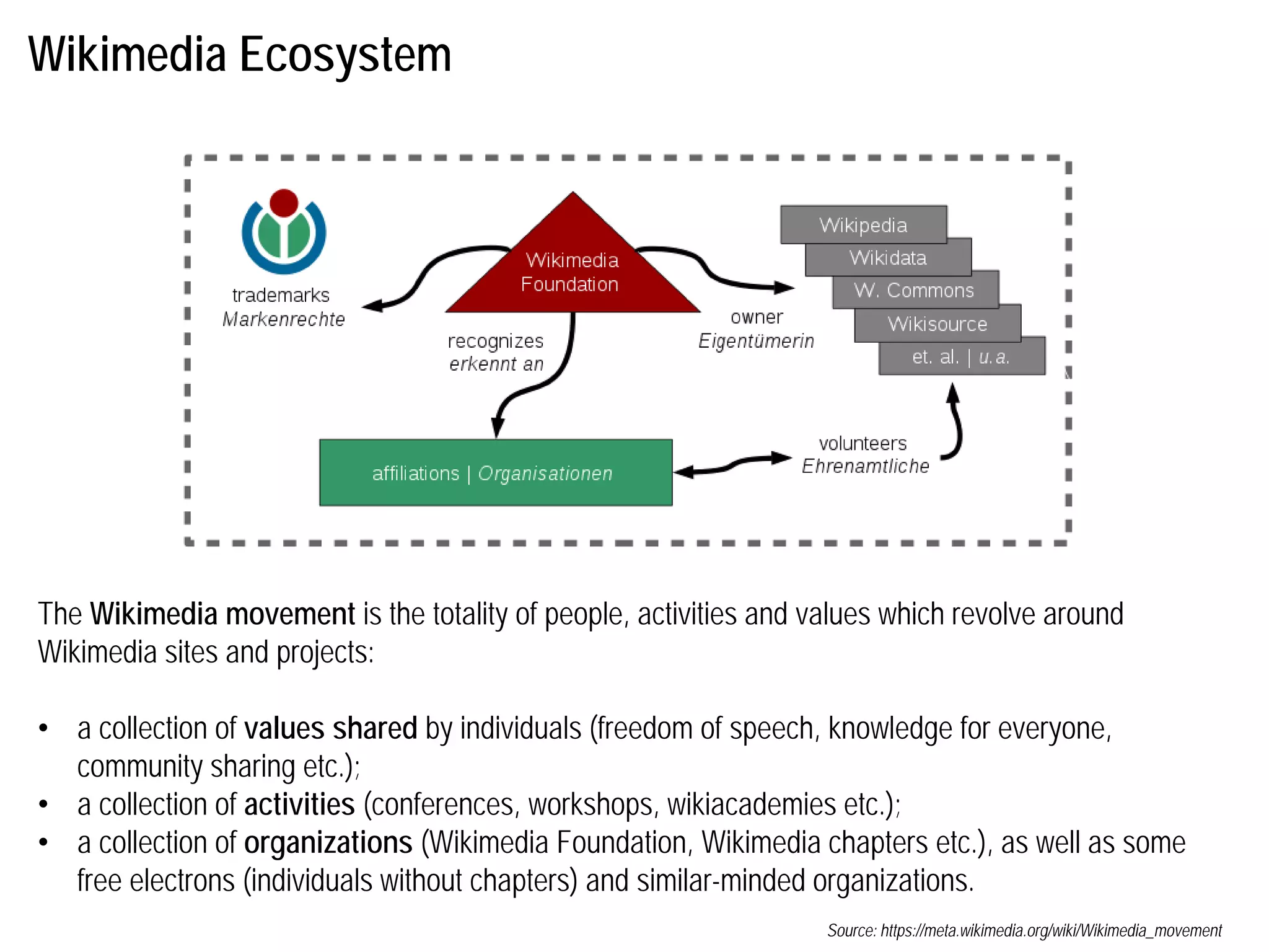
Wikimedia Ecosystem
The Wikimediamovement is the totality of people, activities and values which revolve around
Wikimedia sites and projects:
• a collection of values shared by individuals (freedom of speech, knowledge for everyone,
community sharing etc.);
• a collection of activities (conferences, workshops, wikiacademies etc.);
• a collection of organizations (Wikimedia Foundation, Wikimedia chapters etc.), as well as some
free electrons (individuals without chapters) and similar-minded organizations.
Source: https://meta.wikimedia.org/wiki/Wikimedia_movement
4.
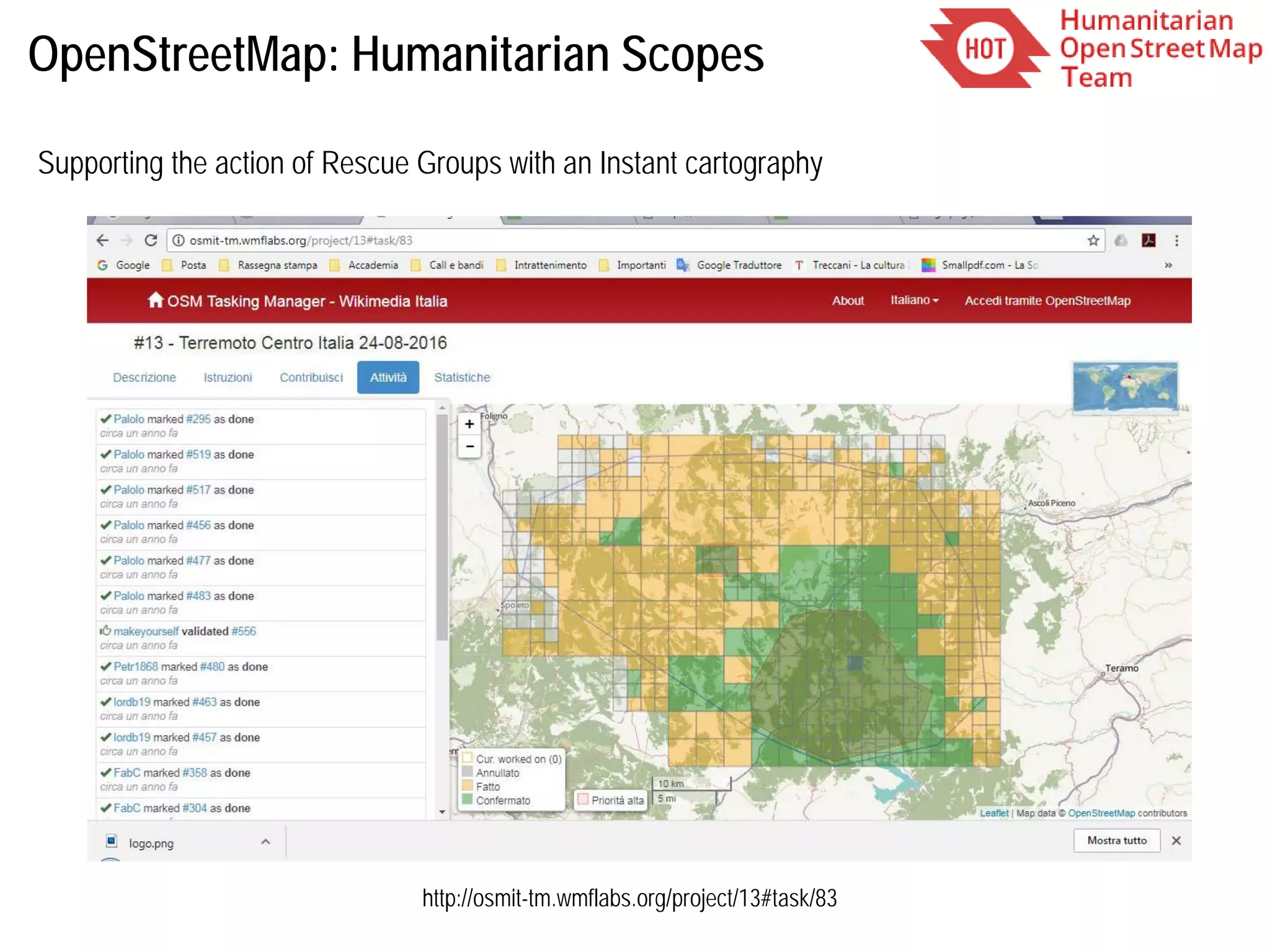
OpenStreetMap: an initiativeaffiliated to Wikimedia Found.
OpenStreetMap is an initiative to create and provide free geographic data, such as street maps, to
anyone. The OpenStreetMap Foundation is an international not-for-profit organization supporting, but
not controlling, the OpenStreetMap Project. It is dedicated to encouraging the growth, development
and distribution of free geospatial data and to providing geospatial data for anyone to use and share.
http://wiki.osmfoundation.org/wiki/Main_Page
5.
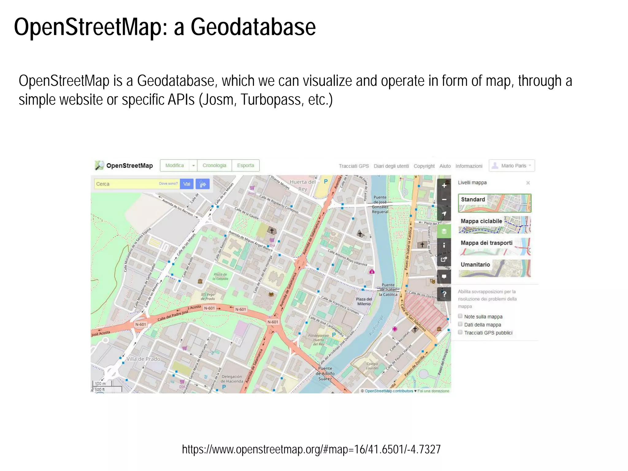
OpenStreetMap: a Geodatabase
OpenStreetMapis a Geodatabase, which we can visualize and operate in form of map, through a
simple website or specific APIs (Josm, Turbopass, etc.)
https://www.openstreetmap.org/#map=16/41.6501/-4.7327
6.
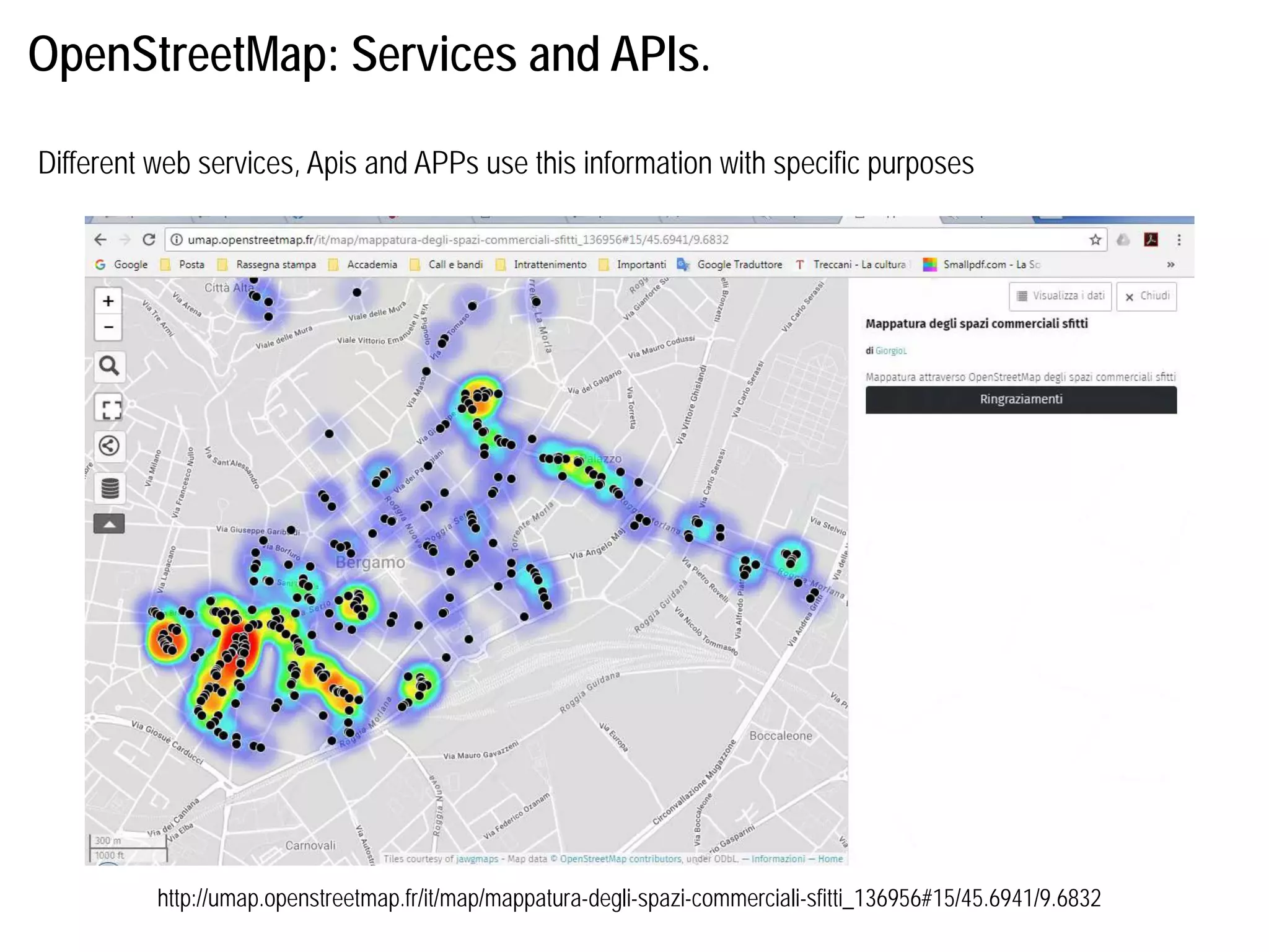
OpenStreetMap: Services andAPIs.
http://umap.openstreetmap.fr/it/map/mappatura-degli-spazi-commerciali-sfitti_136956#15/45.6941/9.6832
Different web services, Apis and APPs use this information with specific purposes
7.
OpenStreetMap: Services andAPIs.
https://wheelmap.org/map#/?lat=41.65038071481791&lon=-4.728069305419922&zoom=16
Different web services, Apis and APPs use this information with specific purposes
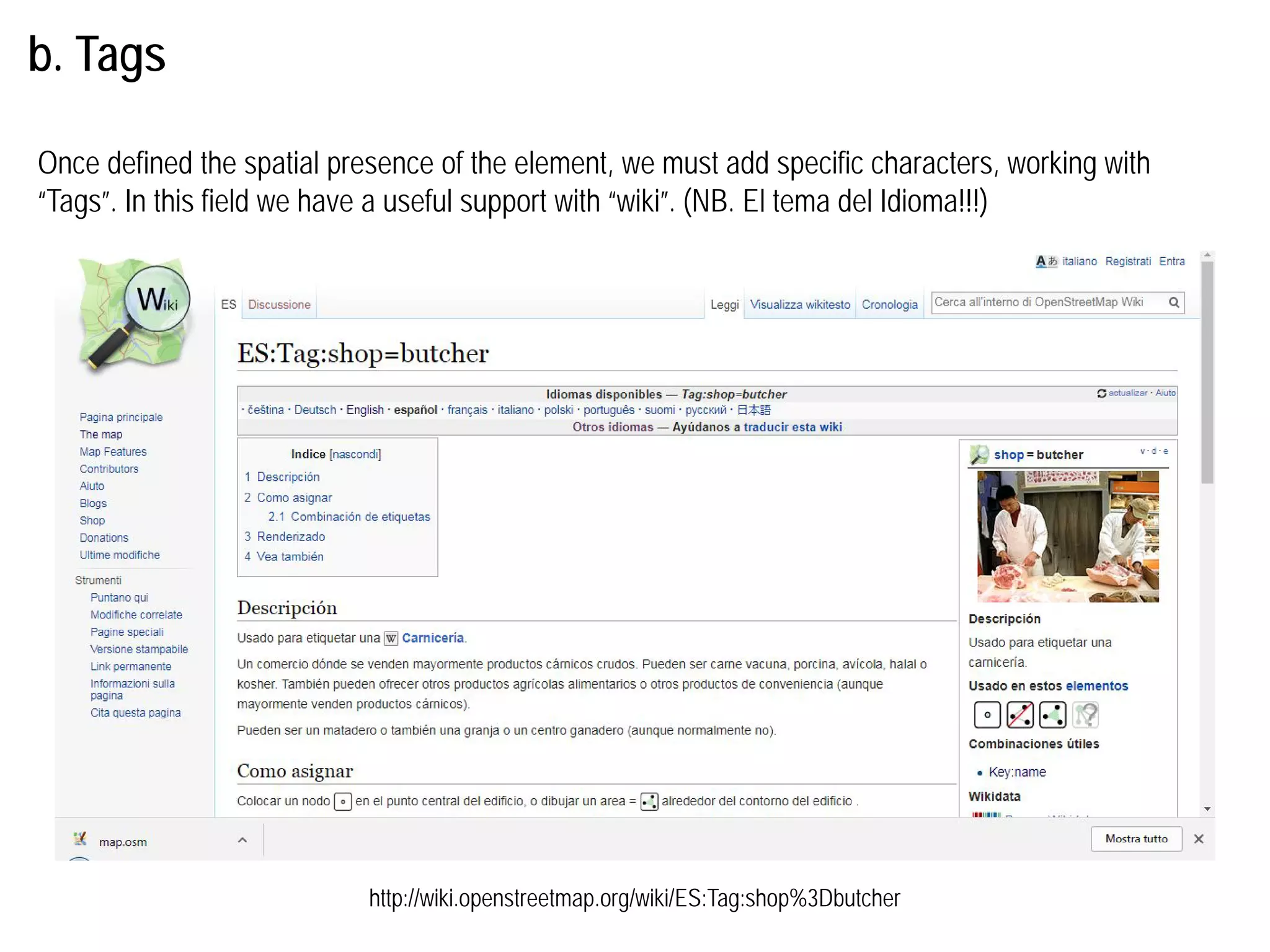
b. Mapping activities
Thephysical characteristics of the territory (called "features") are represented using labels (called
"tags“ o “etiquetas”) assigned to the geometric elements consisting of nodes ("nodes"), paths ("way"
using to represent polyline-polygons ) and relationships ("relation" using to represent logical or
geographical relationships between the elements).
How can it be used to mapping the territorial elements?
- node: used to mapping punctual elements
- way: used to mapping buildings, elements with a physical presence
- relation: used to define the logical relationship between building parts or objects.
General Info
Info tag
Pais/Countryaddr:country
Ciudad/City addr:city
Codigo/Code addr:postcode
Calle/Street addr:street
Civico/Number (if letter,
before add an «/»)
addr:housenumber
Ref. Calle/Ref. Street loc_ref
Nombre name
Horarios/Opening Hours opening_hours
Compania/Brand operator
Terraza/Dehor biergarten
Info tag
Ethnicity/Etnich info
(“chinese”, “latinamerican”)
origin
Source
(“survey”)
source
Floor level
(values“0”, “1”, “-1”)
level
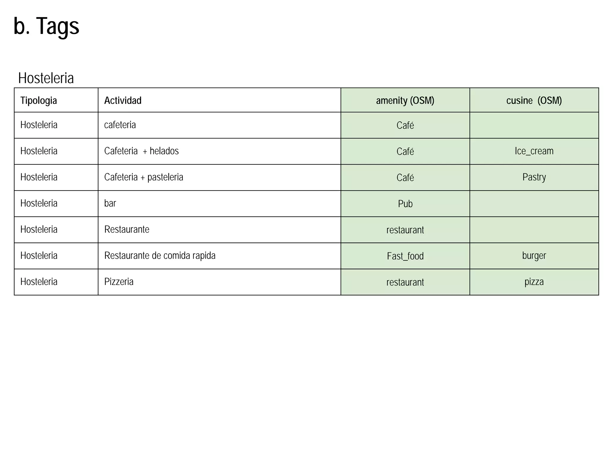
b. Tags
23.
Tipologia Specifica merceologicashop (OSM) clothes (OSM)
Food wine wine
Food supermarket supermarket
Food Nespresso coffee
Food carnicero butcher
Food submarinos convenience
Food frutero greengrocer
No-food Ropa para ninos baby_goods
No-food Ropa deportiva sports
No-food Ropa interior clothes underwear
No-food Todo a 100 gift
No-food moviles mobile_phone
No-food Muebles y complementos furniture
No-food bricolage doityourself
Tiendas
b. Tags
24.
Tipologia Specifica merceologicashop (OSM) books (OSM)
No-food artículos para el hogar houseware
No-food coches car
No-food Drones y maquetas model
No-food electrónica electronics
No-food Herbalista herbalist
No-food Flores florist
No-food Papeleria stationery
No-food comics books comic
No-food Arte y esculturas art
No-food Juguetes toys
No-food Joyeria jewelry
No-food Ordenadores computer
No-food libros books
Tiendas
b. Tags
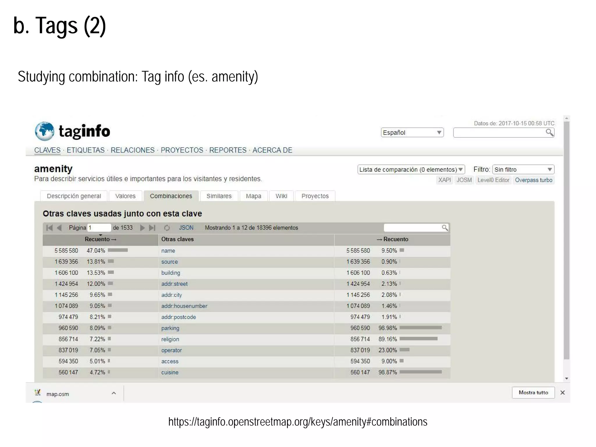
c. How to:comparing maps
http://tools.geofabrik.de/mc/#14/41.6609/-4.7662&num=4&mt0=mapnik&mt1=google-map&mt2=google-satellite&mt3=geofabrik-topo
Testing the existing information
29.
c. How to:updating location, geometry and/or information
Updating existing information
Miércoles 18 deoctubre/Wednesday, October 18
11h30-13h30:
Workshop. WP2: Práctica de campo (alrededor de la ETS de Arquitectura)
17h30-19h30:
Workshop. WP3: Restitución y organización de datos