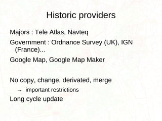
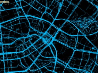
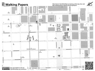
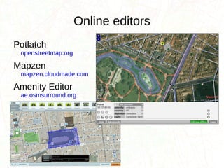
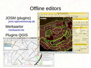
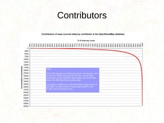
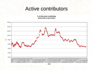
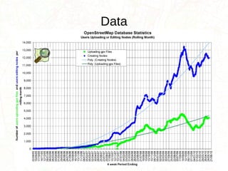
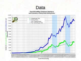
This document introduces OpenStreetMap (OSM), an open collaborative project to create a free editable map of the world. OSM aims to provide free geographic data like street maps to anyone through crowdsourcing contributions. The document outlines how to contribute data through field mapping, data tracing, and online/mobile editors. It also discusses OSM data licensing and reuse, ensuring open geographic data for all.
Webinar presentation for the GIS course held by Professor Maria Brovelli at Politecnico di Milano. As a PoliMappers officer, I introduced the attendants to the project of OSM, highlighting its main idea and concepts.
Humanitarian OpenStreetMap Team at UNGIWG 10
Presentation compiled by Nicolas Chavent
Presentation presented by Sandra Sudhoff
(many thanks Nicolas and Sandra!)
Geopaparazzi is an application for fast field surveys. Its simplicity and the possibility to use it on as good as any android smartphone makes it a trusty field companion for engineers and geologists, but also for tourists who wish to keep a geodiary and any user that needs to be aware of his position even in offline mode.
In Geopaparazzi it is possible to create text, picture and sketch notes and place them on the map. Notes can also be complex and form based in order to standardize surveys in which many people need to be coordinated.
In the last years the support for the visualization of spatialite vector layers and recently also editing possibilities for spatialite poligonal datasets has been added, allowing for some simple-yet-powerfull possibilities on vector data. Desktop tools are supplied to bring datasets from the GIS environment to Geopaparazzi and back.
The presentation will focus on the most important features of Geopaparazzi as well as the latest additions to the application in order to give a complete idea of the state of the art of the project.
OpenGeoData Italia - Roma - Simone Cortesi | Maurizio Napolitano | openstreet...Simone Cortesi
Discussione su OpenStreetMap, sistemi GIS classici, confronti, potenzialità di OSM e dei suoi strumenti di estrazione dati.
Slide per la conferenza OpenGeoData Italia - Roma - 27 febbraio 2014.
Presentation given at the Where2.0Now conference in Harrogate
Blog post about the talk:
http://www.harrywood.co.uk/blog/2009/11/12/openstreetmap-at-where20now/
OpenStreetMap and CycleStreets: collaborative map-making and cartography in t...CycleStreets
Abstract: The arrival of web-based mapping from Google and others has revolutionised, in the space of only five years, the way many people interact with maps and map data. And the success of projects such as Wikipedia highlight how collation of small amounts of information from large numbers of people - an approach called 'crowdsourcing' - can challenge traditional models of data collection and ownership. Bringing these concepts together is OpenStreetMap, a collaborative project to create a free editable map of the world. Well-established enterprises such as the Ordnance Survey are coming under increased pressure from this new model, and large companies such as MapQuest and Microsoft are starting to use and invest in it. Martin Lucas-Smith, Webmaster in the Department, and one of two main developers of the leading UK-wide cycle journey planner website, CycleStreets, will discuss OpenStreetMap, its use within a wide range of systems (from cartography, routing, and even its central role helping deal with the Haiti disaster) and discuss the challenges it poses to traditional forms of cartography and data collection.
Very short 10 minute presentation showing the similarites between OpenStreetMap and wikipedia. I gave the talk at London Wiki Wednesdays: http://www.socialtext.net/wikiwed/index.cgi?london_wikiwed_7_october_2009_what_happened
See also blog post: http://www.harrywood.co.uk/blog/2009/10/09/osm-talk-at-london-wiki-wednesdays/
OpenStreetMap Presentation to Fairfax Advocates for Better Bicycling: How OSM...Josh Doe
This was a presentation I gave to Fairfax Advocates for Better Bicycling (FABB) at the Patrick Henry Library in Vienna, Virginia on August 17, 2011. I covered the basics of OpenStreetMap, what can be done with OSM, and specifically how it might help with the Safe Routes to School (SRTS) program. If you'd like to find out more about the SRTS Mapping Toolkit, visit http://wiki.openstreetmap.org/wiki/Safe_Routes_to_School_Mapping_Toolkit.
Cartography: Vector Tiles From an Open Initiative To an Industry StandardFrédéric Rodrigo
Vector tiles allow you to create interactive maps on the web. They come from a need of a free and competitive solution again Google Maps(c). After several iterations, they are now becoming a standard and are already a standard in the web mapping industry, for free ecosystem but also beyond. This presentation reviews the history, functionality and adoption of vector tiles.
At the beginning, Osmose-QA is a Quality Assurance tool pointing issues on map, but also able to compare external data set to OpenStreetMap.
First talk part is about the new support of MapCSS rules in Osmose-QA. MapCSS language was primarily designed as way to style map objects, it look like the web styling language CSS. The base of MapCSS is to use selectors to filter objects. JOSM already use it for map styling and validator. This new implementation of MapCSS in Osmose-QA allows to write rules more easily. It also allow to reuse JOSM validator rules set. Next step would be to run Osmose rules in JOSM. It’s a great opportunity to share rules across tools and projects. But come the question on how to share and manage this rules while considering tools particularities.
Second talk part is on external data comparison (aka conflation) with OpenStreetMap. It permits to point issues and evaluate the coverage, lastly it allows fixing and integration into OpenStreetMap. The more we wait, the more there is OpenData sets available. How Osmose-QA can try to addresses this issue of already too many OpenData set available. Beside OpenData from authorities we also have street objects extracted by Mapillary AI from street photography. Finally, what about the limit of the current model and how we may go further.
Automatic Enhancement of Pedestrian Route using extracted Landmarks from OSMFrédéric Rodrigo
Replacing the classics “Turn right after the bakery” by more natural language and incorporating landmarks, to allow users to move in and around stations with more confidence, is still only a research topic. SNCF Innovation & Research has entrusted Makina Corpus with the implementation of the state of the art in this field. The objective is to improv it on an indoor/outdoor pedestrian route calculator under development.
Anything that can be used as a landmark is extracted from OpenStreetMap and then categorized and classified. The landmarks are then evaluated to annotate the route: relevance, visibility, relative position.... The SNCF context has the particularity of having to deal with transition between indoor and outdoor.
Annoter automatiquement un itinéraire piéton avec des repères issus d'OSMFrédéric Rodrigo
Remplacer les classiques « Continuez sur 200 m puis tournez à gauche » par des indications en langage plus naturel et intégrant des repères, pour permettre aux usagers de se déplacer dans et autour des gares avec plus de confiance, n’est encore qu’un sujet de l’ordre de la recherche. SNCF Innovation & Recherche a confié à Makina Corpus l’implémentation de l’état de l’art dans ce domaine. L’objectif est de l’expérimenter sur un calculateur d’itinéraire piéton indoor/outdoor en cours de développement.
Tout ce qui peut servir de repère est extrait d’OpenStreetMap puis catégorisé et classé. Les repères sont ensuite évalués pour annoter l’itinéraire : pertinence, visibilité, position relative... Le contexte de la SNCF a la particularité de devoir traiter des espaces de transition entre l’indoor et l’outdoor.
Dernières avancées d'Osmose-QA : reprise des analyses pour réduire le temps de traitement et passage à Docker pour faciliter les contributions au projet. Mais surtout le nouveau support des MapCSS du validateur JOSM pour mettre en place un framework de validation commun. Osmose prend désormais en charge les règles de validation MapCSS de JOSM et les règles Osmose-QA peuvent également être en partie écrites en MapCSS pour être utilisé dans JOSM.
OSRM (Open Source Routing Machine) est un calculateur d'itinéraire utilisant les données d'OSM. Son approche est d'être rapide, au détriment historiquement de la flexibilité. Mais il commence à avoir plus fonctionnalités tout en restant très rapide. De plus il peut être personnalisé pour coller à d'autres besoins : retour d'expérience et d'expérimentation sur le support de profils de vitesses différents en fonction du contexte, d'options comme utiliser ou non les autoroutes ou encore de calcul d'isochrones.
Et si on participait tous ensemble comme collecteur de l'état du trafic routier de façon libre. Extrêmement peu de données de trafic sont disponibles librement. Aujourd'hui seules de grandes compagnies sont capables d'agréger les informations collectées et de produire des informations sur le trafic. Chaque fourmi que nous sommes peut être un capteur pour produire un flux libre de données trafic. La solution technique existe déjà : c'est "Open Traffic", mais il faut l'alimenter.
Stat of the Map-US 2015. OpenStreetMap Osmose-QA tool
Osmose QA, is a quality assurance tool detecting errors and inconsistencies in OpenStreetMap data. Osmose QA is one of the largest sets of QA rules applied to OpenStreetMap data. It’s also one of the most functional tools of this kind : proposed corrections, localized checks (like language or driving side), API, online editor, help for OpenData integration and so forth.
This tool is made up of a web front end and many backends for checking countries. Backends analyze data and report errors, with PostGIS, Sax and OpenData integration. The frontend displays errors on a slippy map, offers an API and export functionality.
The world coverage for analyzis is still growing, and since spring, Osmose QA is also available for the United States.
Search and Society: Reimagining Information Access for Radical FuturesBhaskar Mitra
The field of Information retrieval (IR) is currently undergoing a transformative shift, at least partly due to the emerging applications of generative AI to information access. In this talk, we will deliberate on the sociotechnical implications of generative AI for information access. We will argue that there is both a critical necessity and an exciting opportunity for the IR community to re-center our research agendas on societal needs while dismantling the artificial separation between the work on fairness, accountability, transparency, and ethics in IR and the rest of IR research. Instead of adopting a reactionary strategy of trying to mitigate potential social harms from emerging technologies, the community should aim to proactively set the research agenda for the kinds of systems we should build inspired by diverse explicitly stated sociotechnical imaginaries. The sociotechnical imaginaries that underpin the design and development of information access technologies needs to be explicitly articulated, and we need to develop theories of change in context of these diverse perspectives. Our guiding future imaginaries must be informed by other academic fields, such as democratic theory and critical theory, and should be co-developed with social science scholars, legal scholars, civil rights and social justice activists, and artists, among others.
Slack (or Teams) Automation for Bonterra Impact Management (fka Social Soluti...Jeffrey Haguewood
Sidekick Solutions uses Bonterra Impact Management (fka Social Solutions Apricot) and automation solutions to integrate data for business workflows.
We believe integration and automation are essential to user experience and the promise of efficient work through technology. Automation is the critical ingredient to realizing that full vision. We develop integration products and services for Bonterra Case Management software to support the deployment of automations for a variety of use cases.
This video focuses on the notifications, alerts, and approval requests using Slack for Bonterra Impact Management. The solutions covered in this webinar can also be deployed for Microsoft Teams.
Interested in deploying notification automations for Bonterra Impact Management? Contact us at sales@sidekicksolutionsllc.com to discuss next steps.
Accelerate your Kubernetes clusters with Varnish CachingThijs Feryn
A presentation about the usage and availability of Varnish on Kubernetes. This talk explores the capabilities of Varnish caching and shows how to use the Varnish Helm chart to deploy it to Kubernetes.
This presentation was delivered at K8SUG Singapore. See https://feryn.eu/presentations/accelerate-your-kubernetes-clusters-with-varnish-caching-k8sug-singapore-28-2024 for more details.
"Impact of front-end architecture on development cost", Viktor TurskyiFwdays
I have heard many times that architecture is not important for the front-end. Also, many times I have seen how developers implement features on the front-end just following the standard rules for a framework and think that this is enough to successfully launch the project, and then the project fails. How to prevent this and what approach to choose? I have launched dozens of complex projects and during the talk we will analyze which approaches have worked for me and which have not.
Connector Corner: Automate dynamic content and events by pushing a buttonDianaGray10
Here is something new! In our next Connector Corner webinar, we will demonstrate how you can use a single workflow to:
Create a campaign using Mailchimp with merge tags/fields
Send an interactive Slack channel message (using buttons)
Have the message received by managers and peers along with a test email for review
But there’s more:
In a second workflow supporting the same use case, you’ll see:
Your campaign sent to target colleagues for approval
If the “Approve” button is clicked, a Jira/Zendesk ticket is created for the marketing design team
But—if the “Reject” button is pushed, colleagues will be alerted via Slack message
Join us to learn more about this new, human-in-the-loop capability, brought to you by Integration Service connectors.
And...
Speakers:
Akshay Agnihotri, Product Manager
Charlie Greenberg, Host
Key Trends Shaping the Future of Infrastructure.pdfCheryl Hung
Keynote at DIGIT West Expo, Glasgow on 29 May 2024.
Cheryl Hung, ochery.com
Sr Director, Infrastructure Ecosystem, Arm.
The key trends across hardware, cloud and open-source; exploring how these areas are likely to mature and develop over the short and long-term, and then considering how organisations can position themselves to adapt and thrive.
The Art of the Pitch: WordPress Relationships and SalesLaura Byrne
Clients don’t know what they don’t know. What web solutions are right for them? How does WordPress come into the picture? How do you make sure you understand scope and timeline? What do you do if sometime changes?
All these questions and more will be explored as we talk about matching clients’ needs with what your agency offers without pulling teeth or pulling your hair out. Practical tips, and strategies for successful relationship building that leads to closing the deal.
GraphRAG is All You need? LLM & Knowledge GraphGuy Korland
Guy Korland, CEO and Co-founder of FalkorDB, will review two articles on the integration of language models with knowledge graphs.
1. Unifying Large Language Models and Knowledge Graphs: A Roadmap.
https://arxiv.org/abs/2306.08302
2. Microsoft Research's GraphRAG paper and a review paper on various uses of knowledge graphs:
https://www.microsoft.com/en-us/research/blog/graphrag-unlocking-llm-discovery-on-narrative-private-data/
DevOps and Testing slides at DASA ConnectKari Kakkonen
My and Rik Marselis slides at 30.5.2024 DASA Connect conference. We discuss about what is testing, then what is agile testing and finally what is Testing in DevOps. Finally we had lovely workshop with the participants trying to find out different ways to think about quality and testing in different parts of the DevOps infinity loop.
Kubernetes & AI - Beauty and the Beast !?! @KCD Istanbul 2024Tobias Schneck
As AI technology is pushing into IT I was wondering myself, as an “infrastructure container kubernetes guy”, how get this fancy AI technology get managed from an infrastructure operational view? Is it possible to apply our lovely cloud native principals as well? What benefit’s both technologies could bring to each other?
Let me take this questions and provide you a short journey through existing deployment models and use cases for AI software. On practical examples, we discuss what cloud/on-premise strategy we may need for applying it to our own infrastructure to get it to work from an enterprise perspective. I want to give an overview about infrastructure requirements and technologies, what could be beneficial or limiting your AI use cases in an enterprise environment. An interactive Demo will give you some insides, what approaches I got already working for real.
Transcript: Selling digital books in 2024: Insights from industry leaders - T...BookNet Canada
The publishing industry has been selling digital audiobooks and ebooks for over a decade and has found its groove. What’s changed? What has stayed the same? Where do we go from here? Join a group of leading sales peers from across the industry for a conversation about the lessons learned since the popularization of digital books, best practices, digital book supply chain management, and more.
Link to video recording: https://bnctechforum.ca/sessions/selling-digital-books-in-2024-insights-from-industry-leaders/
Presented by BookNet Canada on May 28, 2024, with support from the Department of Canadian Heritage.
PHP Frameworks: I want to break free (IPC Berlin 2024)Ralf Eggert
In this presentation, we examine the challenges and limitations of relying too heavily on PHP frameworks in web development. We discuss the history of PHP and its frameworks to understand how this dependence has evolved. The focus will be on providing concrete tips and strategies to reduce reliance on these frameworks, based on real-world examples and practical considerations. The goal is to equip developers with the skills and knowledge to create more flexible and future-proof web applications. We'll explore the importance of maintaining autonomy in a rapidly changing tech landscape and how to make informed decisions in PHP development.
This talk is aimed at encouraging a more independent approach to using PHP frameworks, moving towards a more flexible and future-proof approach to PHP development.
State of ICS and IoT Cyber Threat Landscape Report 2024 previewPrayukth K V
The IoT and OT threat landscape report has been prepared by the Threat Research Team at Sectrio using data from Sectrio, cyber threat intelligence farming facilities spread across over 85 cities around the world. In addition, Sectrio also runs AI-based advanced threat and payload engagement facilities that serve as sinks to attract and engage sophisticated threat actors, and newer malware including new variants and latent threats that are at an earlier stage of development.
The latest edition of the OT/ICS and IoT security Threat Landscape Report 2024 also covers:
State of global ICS asset and network exposure
Sectoral targets and attacks as well as the cost of ransom
Global APT activity, AI usage, actor and tactic profiles, and implications
Rise in volumes of AI-powered cyberattacks
Major cyber events in 2024
Malware and malicious payload trends
Cyberattack types and targets
Vulnerability exploit attempts on CVEs
Attacks on counties – USA
Expansion of bot farms – how, where, and why
In-depth analysis of the cyber threat landscape across North America, South America, Europe, APAC, and the Middle East
Why are attacks on smart factories rising?
Cyber risk predictions
Axis of attacks – Europe
Systemic attacks in the Middle East
Download the full report from here:
https://sectrio.com/resources/ot-threat-landscape-reports/sectrio-releases-ot-ics-and-iot-security-threat-landscape-report-2024/
Description avec des termes à la mode Wiki : Collaboratif Crowdsourcing : approvisionnement par la foule, externalisation à grande échelle Néogéographie : cartographie en ligne, web 2.0, mashup OSM n'est pas : Un clone de google map (pas d'image aérienne, d'api orienté utilisation) Une carte Juste une base de données
Cartographie automatique par véhicule Les cartes existantes sont rarement libre -> www.flickr.com Pékin -> google map Gaza -> google map Bagdad -> google map Chypre – source de la données -> Yahoo map Chypre - idem -> Bing map Chypre - idem
Comment ne pas parler de Google, le nouveau grand méchant Que des images pas de données Orienté voiture : -> ggm cité de Carcassonne voir: les remparts sont une route, voir photo, comparer avec OSM Remarque fournisseurs Plus de fournisseur pour les USA -> ggm NYC licence droit à Google, pas de concurrence, inspiré d'OSM Pas de concurrence frontale avec les fournisseurs Pas de concurrence des données avec Google. -> http://google.com/mapmaker Petite démo -> voir les conditions d'utilisation -> voir la page de téléchargement https://services.google.com/fb/forms/mapmakerdatadownload/ chap 10.2, 10.4, 10.5
http://creativecommons.org/licenses/by-sa/2.0/ Les auteurs restent propriétaires des contributions Utilisation commerciale possible
http://www.opendatacommons.org/licenses/odbl/1.0/ Double licence pour les nouveaux utilisateurs Perte éventuelle de données
Pas un google map, pas d'outils -> Démo La carte : Les rendues, Permalink, La recherche passer les onglets en revue Zone utilisateurs
OSM réponse à un manque de données accessibles
Cartographier le mode, projet qui parait fou au premier abord quand on en parle à quelqu'un : pourquoi refaire une carte alors qu'il en existe déjà Aussi fou que faire une encyclopédie, que de bâtir une cathédrale Projet libre encore plus fou : voiture libre... Un travail de fourmis Exploration et appropriation citoyenne du territoire Excitation comme les grands découvreur Découverte de son quartier, de lieu proche ou l'on passe
Gps de moins en mois cher, compris dans les smartphone Idem photo Photo géolocalisé ou post-géolocalisé
Accumulation de traces GPS permettent de localiser et d'affiner les positions Centre de Berlin -> upload sur osm.org Les traces gps sont une source de donnée et pas donnée elle même : à retravailler
Nom des rues Type de rue, primaire, secondaire, autoroute, voie rapide, résidentielle, zone de rencontre... Sens unique, feux rouge, limitation de vitesse, interdiction de faire demi tours POI : école, poste, mairie, église, boite aux lettres, arrêt de bus, point recyclage... Encore plus loin : dos d'âne, numéro des bâtiments dans la rue, passage piétons, lampadaires, arbres...
Après autorisation uniquement de créer une œuvre dérivé compatible avec la licence OSM Yahoo! Disponible dans les grandes zone urbaines Landsat beaucoup plus disponible mais résolution plus faible (et géoréférencement moins bon) Cadastre de la DGI : droit uniquement pour la création d'une œuvre composite depuis le WMS (raster), les voies sont les vides entres les parcelles GéoLittoral : othophoto et sentier côtier sous licence IP
Dérivation depuis Yahoo! avec l'éditeur en ligne Potlach -> Démo
Dérivation du cadastre de la DGI avec l'éditeur JOSM
Potlach éditeur en ligne par défaut - simple Mapzen créer par Cloudmade (OSM corp) – encore plus simple -> démo
JOSM, beaucoup de fonctionnalités, plugins Merkaartor, moins utilisé -> démo plus tard
Attribution libre Besoin homogénéité : rendu, routage, recherche Discutions ML, wiki: vote Proposition suite a un besoin réel rencontré sur le terrain. Utiliser le tag puis le proposer, pas l'inverse.
-> démo sur le site
En 2007 AND ne valide pas sur le terrain Réponse à MapShare de TomTom Après vérification de la compatibilité de la licence Import important uniquement CLC donne de la couleur à la France : occupation des sols, licences différentes par pays http://osm.org/go/xVgcBr Import CUBrest cadastre http://osm.org/go/erDzBLLdX-
CLC donne de la couleur à la France : occupation des sols, licences différentes par pays http://osm.org/go/xVgcBr Import CUBrest cadastre http://osm.org/go/erDzBLLdX-
Fondation, SOTM Langues, problèmes et solutions communs
Convergence obtenu par contributions multiples, effet de fourmilière : sur les données et l'ontologie Surveillance et correction On n'arrive pas à la « meilleure qualité possible » par cette méthode, mais à un maximum local
Bordeaux Zone cartographié, puis corrigé par d'autres http://www.itoworld.com/product/osm
Possède et héberge les serveurs Collecte des dons et finance des actions Défend en justice le licence d'OSM (jamais encore arrivé) Objectif de fédérer les Local Chapters (associations locales) Stat of the map, 2010, Girona, Spain
Phase de croissance exponentielle
-> Wikimedia Sortie de la phase de croissance exponentielle Pas En car top haut http://stats.wikimedia.org/EN/PlotsPngWikipediansContributors.htm
Règle des 80%-20% Longe queue http://wiki.openstreetmap.org/wiki/Stats
Ne pas prendre la fin comme une baisse, c'est un effet saisonnier
Apparition d'un phénomène de novembre à février. Avec un plus bas pour noël
/! à la classification -> FR:Map Features Motorway/2 Primary + trunk/2 Secondary + tertiary Residential + unclassified Footway + path Cycleway (uniquement) Pedestrian Steps Http://pedrov.kwain.net/osmstats
/! à la classification -> OSM Inspector : water
La qualité s'obtient par la collaboration, le raffinement, le consensus et la consolidation des sources Relation cheker Noname beta.letuffe.org -> démo : site
Accès directement sur le serveur racine -> démo depuis le site
-> démo des rendus depuis osm.org
Openlayers moteur de cartes dynamiques pour sites web Openlayers POI layer example : http://wiki.openstreetmap.org/wiki/Openlayers_POI_layer_example#The_files http://wiki.openstreetmap.org/wiki/OpenLayers
Générique : auto, cycliste, piéton Roadeeno http://www.aemade.net/router/web/www/routino/customrouter.cgi Webservice : utilisation par des applications mobiles http://wiki.openstreetmap.org/wiki/Routing/OnlineRouters
CartoType – non libre http://wiki.openstreetmap.org/wiki/Routing/OfflineRouters
Temps de parcours Géo-codage et décodage Api nominatim Expérience Mappy
http://213.246.61.77:8083/lutece/jsp/site/Portal.jsp?page_id=207 MdM Ville du Libre http://www.plouarzel.com/spip.php?article226 Office du tourisme
-> vidéo -> la carte
-> démo Gaza
OSM ne convient pas tous les besoins. Il faut étudier quel est le besoin réel. OSM est une solution entre des jeux de données isolées et des solutions globales et homogène.
Josm : project Temps de mise à jour sur le serveur