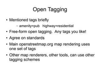
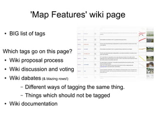
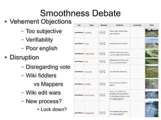
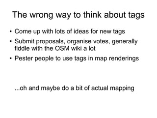
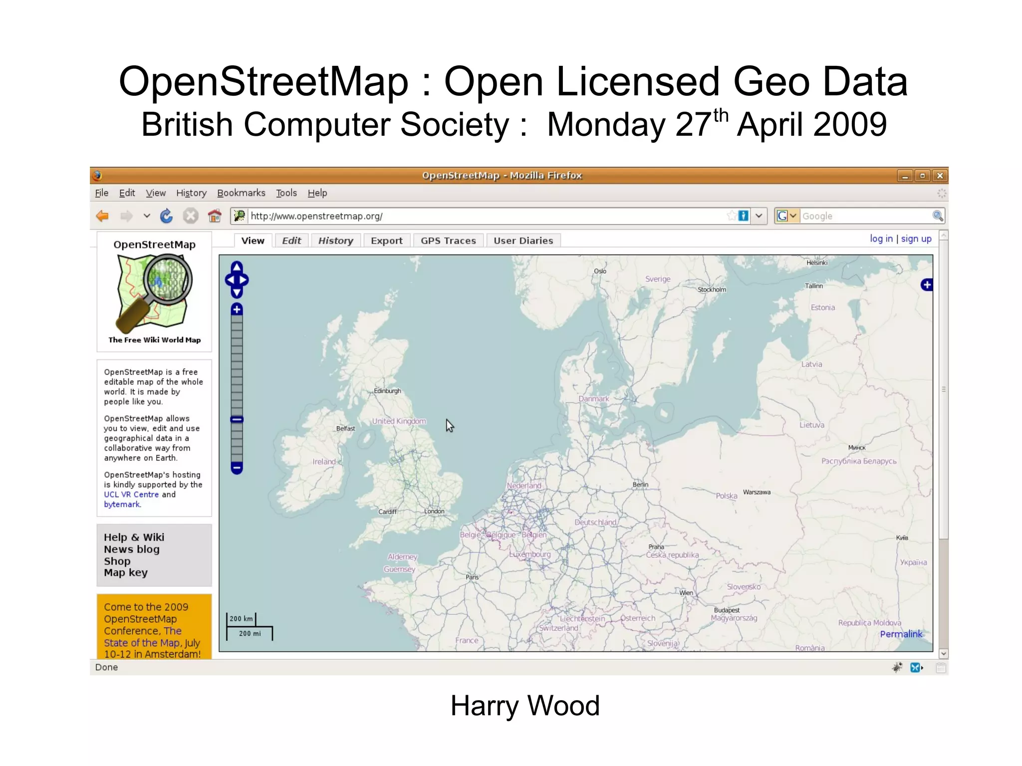
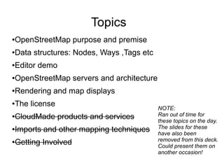
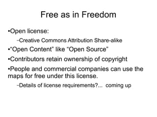
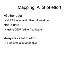
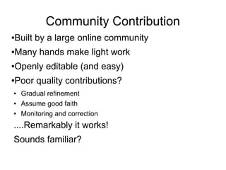
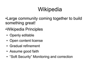
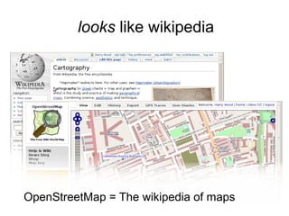
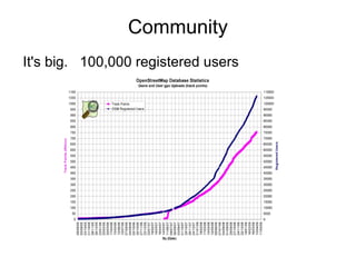
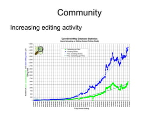
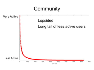
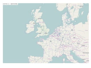
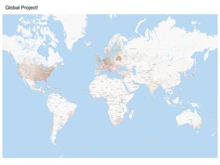
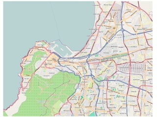
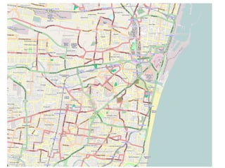
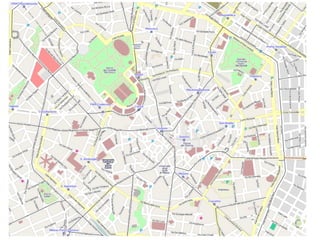
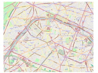
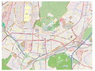
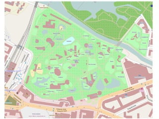
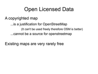
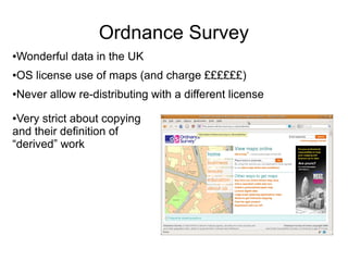
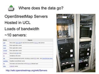
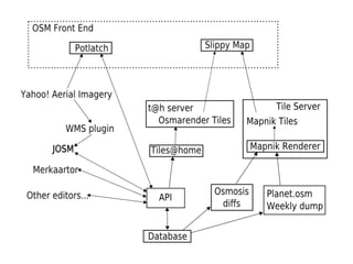
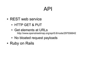
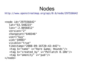
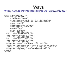
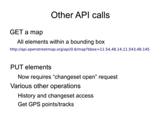
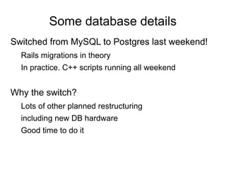
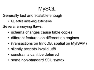
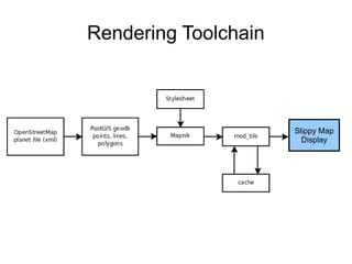
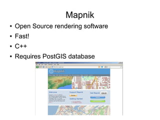
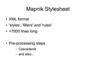
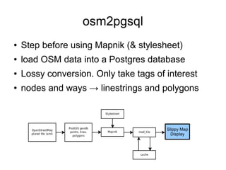
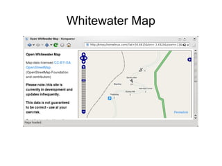
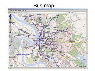
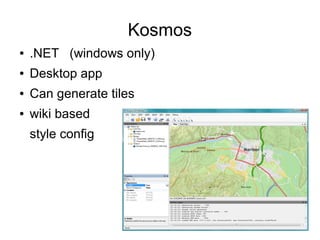
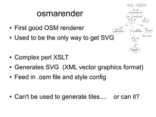
This document summarizes a presentation about OpenStreetMap. It discusses OSM's purpose of creating an openly licensed map, its data structures of nodes, ways and tags, and tools for editing and viewing map data. OSM is built by a large volunteer community contributing GPS traces and other mapping data. Its data is hosted on servers and rendered into map tiles using tools like Mapnik. The presentation highlights OSM's open licensing and wiki-based approach to tagging locations, similar to Wikipedia.
We won the Sprint national recruitment account in 2001. This slide show offers a peek into the evolution of a major brand, from the work we produced to win the account, to the telcom giant\'s first major brand update, through its merger with Nextel, to it\'s current positioning.
iParty, a New England-based party supply store, experiences an enormous surge in business each year around the Halloween season. We helped ensure necessary staffing levels for the busy season by developing an employee referral campaign, inviting their existing staff to assist in the recruitment effort. The theme of the program, "The IPPRENTICE", was a spoof on the popular celebrity reality show, The Apprentice, with the tagline "Your Hired!". The poster, brochure and referral entry card were modeled after memorable icons from Donald Trump\'s tv show.
State of GeoServer, GeoTools and Friends 2014Jody Garnett
GeoServer and the Java toolkit GeoTools comprise one of OSGeo’s fastest moving mapping ecosystems. In addition to this core we will cover java-stack developments in JTS, GeoWebCache and ImageIO-Ext.
First up is “State of GeoServer” reviewing the new and noteworthy features introduced in the past year. Our six month release cycle sees GeoServer 2.5 and 2.6 being released this year. These releases bring together exciting new features: WCS 2.0 and WCS 2.0 Earth Observation profile, batch importer, and a fresh implementation of GetFeatureInfo.
Switching to technical for a GeoTools update. A passion for performance sees improvements in PNG and JPEG encoding, rendering from PostGIS and experimental JDK work. This presentation provides a review of new features, api changes and community modules. We have simplified the core FeatureCollection interface, introduced partial 3D support, structured grid coverages, multiple grid coverages and extended JTS Geometry with Curves.
Data formats support continues to grow with the latest GeoPackage, native NetCDF support and a new shapefile and wfs client implementation. Database users have table and index management methods to look forward to. Extensions have seen a lot of activity with WMS client improvements, vector grids, and a transform extension for dynamic feature collection processing.
Attend this talk for a cheerful update on what is happening with these great OSGeo projects! Whether you are an expert user, a developer, or simply curious what these projects can do for you, this talk is for you.
https://social.samsunginter.net/web/statuses/101091908485239453# #Cdl2018 : #WebThing using #WebThingIotJs on #TizenRT on #ARTIK05x connected to @MozillaIot featuring @The_Jst #JerryScript + #IotJs , video to be published by @CapitoleDuLibre
webthing-iotjs-tizenrt-cdl2018-20181117rzr
Digibury: SciVisum - Making your website fast - and scalableLizzie Hodgson
Deri Jones is a renowned speaker and thought-leader in the Web performance arena. In his Digibury talk he not only covered war-stories from many years in the web performance space, he also gave tips on making any page fast, and explained how to use open-source tools in addressing the challenges of scaling.
Build "Privacy by design" Webthings
With IoT.js on TizenRT and more
#MozFest, Privacy and Security track
Ravensbourne University, London UK <2018-10-27>
GeoServer is an amazing project, and an amazing project to work on!
Please attend this workshop to:
* Get Started with the GeoServer codebase
* Orientation with a Tour of the GeoServer architecture
* Introduction the service dispatch framework, includin creating your own service
* Built chain and test facilities
* Create a custom function for use with map styling
* Create a custom process for use with style transformations and web processing service
* Anatomy of a successful pull request
Attendees will build their own GeoServer, learn a bit about how our community operates, and enjoy extending the base application.
If you are a developer looking to support GeoServer, or join us for a sprint or bug-stomp, this workshop is great introduction.
This course features hands-on development. We encourage and expect you to bring your favourite Java development environment.
For a good time with open source join GeoServer today!
The Art of the Pitch: WordPress Relationships and SalesLaura Byrne
Clients don’t know what they don’t know. What web solutions are right for them? How does WordPress come into the picture? How do you make sure you understand scope and timeline? What do you do if sometime changes?
All these questions and more will be explored as we talk about matching clients’ needs with what your agency offers without pulling teeth or pulling your hair out. Practical tips, and strategies for successful relationship building that leads to closing the deal.
Builder.ai Founder Sachin Dev Duggal's Strategic Approach to Create an Innova...Ramesh Iyer
In today's fast-changing business world, Companies that adapt and embrace new ideas often need help to keep up with the competition. However, fostering a culture of innovation takes much work. It takes vision, leadership and willingness to take risks in the right proportion. Sachin Dev Duggal, co-founder of Builder.ai, has perfected the art of this balance, creating a company culture where creativity and growth are nurtured at each stage.
Dev Dives: Train smarter, not harder – active learning and UiPath LLMs for do...UiPathCommunity
💥 Speed, accuracy, and scaling – discover the superpowers of GenAI in action with UiPath Document Understanding and Communications Mining™:
See how to accelerate model training and optimize model performance with active learning
Learn about the latest enhancements to out-of-the-box document processing – with little to no training required
Get an exclusive demo of the new family of UiPath LLMs – GenAI models specialized for processing different types of documents and messages
This is a hands-on session specifically designed for automation developers and AI enthusiasts seeking to enhance their knowledge in leveraging the latest intelligent document processing capabilities offered by UiPath.
Speakers:
👨🏫 Andras Palfi, Senior Product Manager, UiPath
👩🏫 Lenka Dulovicova, Product Program Manager, UiPath
Epistemic Interaction - tuning interfaces to provide information for AI supportAlan Dix
Paper presented at SYNERGY workshop at AVI 2024, Genoa, Italy. 3rd June 2024
https://alandix.com/academic/papers/synergy2024-epistemic/
As machine learning integrates deeper into human-computer interactions, the concept of epistemic interaction emerges, aiming to refine these interactions to enhance system adaptability. This approach encourages minor, intentional adjustments in user behaviour to enrich the data available for system learning. This paper introduces epistemic interaction within the context of human-system communication, illustrating how deliberate interaction design can improve system understanding and adaptation. Through concrete examples, we demonstrate the potential of epistemic interaction to significantly advance human-computer interaction by leveraging intuitive human communication strategies to inform system design and functionality, offering a novel pathway for enriching user-system engagements.
GraphRAG is All You need? LLM & Knowledge GraphGuy Korland
Guy Korland, CEO and Co-founder of FalkorDB, will review two articles on the integration of language models with knowledge graphs.
1. Unifying Large Language Models and Knowledge Graphs: A Roadmap.
https://arxiv.org/abs/2306.08302
2. Microsoft Research's GraphRAG paper and a review paper on various uses of knowledge graphs:
https://www.microsoft.com/en-us/research/blog/graphrag-unlocking-llm-discovery-on-narrative-private-data/
Kubernetes & AI - Beauty and the Beast !?! @KCD Istanbul 2024Tobias Schneck
As AI technology is pushing into IT I was wondering myself, as an “infrastructure container kubernetes guy”, how get this fancy AI technology get managed from an infrastructure operational view? Is it possible to apply our lovely cloud native principals as well? What benefit’s both technologies could bring to each other?
Let me take this questions and provide you a short journey through existing deployment models and use cases for AI software. On practical examples, we discuss what cloud/on-premise strategy we may need for applying it to our own infrastructure to get it to work from an enterprise perspective. I want to give an overview about infrastructure requirements and technologies, what could be beneficial or limiting your AI use cases in an enterprise environment. An interactive Demo will give you some insides, what approaches I got already working for real.
Accelerate your Kubernetes clusters with Varnish CachingThijs Feryn
A presentation about the usage and availability of Varnish on Kubernetes. This talk explores the capabilities of Varnish caching and shows how to use the Varnish Helm chart to deploy it to Kubernetes.
This presentation was delivered at K8SUG Singapore. See https://feryn.eu/presentations/accelerate-your-kubernetes-clusters-with-varnish-caching-k8sug-singapore-28-2024 for more details.
Transcript: Selling digital books in 2024: Insights from industry leaders - T...BookNet Canada
The publishing industry has been selling digital audiobooks and ebooks for over a decade and has found its groove. What’s changed? What has stayed the same? Where do we go from here? Join a group of leading sales peers from across the industry for a conversation about the lessons learned since the popularization of digital books, best practices, digital book supply chain management, and more.
Link to video recording: https://bnctechforum.ca/sessions/selling-digital-books-in-2024-insights-from-industry-leaders/
Presented by BookNet Canada on May 28, 2024, with support from the Department of Canadian Heritage.
UiPath Test Automation using UiPath Test Suite series, part 4DianaGray10
Welcome to UiPath Test Automation using UiPath Test Suite series part 4. In this session, we will cover Test Manager overview along with SAP heatmap.
The UiPath Test Manager overview with SAP heatmap webinar offers a concise yet comprehensive exploration of the role of a Test Manager within SAP environments, coupled with the utilization of heatmaps for effective testing strategies.
Participants will gain insights into the responsibilities, challenges, and best practices associated with test management in SAP projects. Additionally, the webinar delves into the significance of heatmaps as a visual aid for identifying testing priorities, areas of risk, and resource allocation within SAP landscapes. Through this session, attendees can expect to enhance their understanding of test management principles while learning practical approaches to optimize testing processes in SAP environments using heatmap visualization techniques
What will you get from this session?
1. Insights into SAP testing best practices
2. Heatmap utilization for testing
3. Optimization of testing processes
4. Demo
Topics covered:
Execution from the test manager
Orchestrator execution result
Defect reporting
SAP heatmap example with demo
Speaker:
Deepak Rai, Automation Practice Lead, Boundaryless Group and UiPath MVP
Generating a custom Ruby SDK for your web service or Rails API using Smithyg2nightmarescribd
Have you ever wanted a Ruby client API to communicate with your web service? Smithy is a protocol-agnostic language for defining services and SDKs. Smithy Ruby is an implementation of Smithy that generates a Ruby SDK using a Smithy model. In this talk, we will explore Smithy and Smithy Ruby to learn how to generate custom feature-rich SDKs that can communicate with any web service, such as a Rails JSON API.
Essentials of Automations: Optimizing FME Workflows with ParametersSafe Software
Are you looking to streamline your workflows and boost your projects’ efficiency? Do you find yourself searching for ways to add flexibility and control over your FME workflows? If so, you’re in the right place.
Join us for an insightful dive into the world of FME parameters, a critical element in optimizing workflow efficiency. This webinar marks the beginning of our three-part “Essentials of Automation” series. This first webinar is designed to equip you with the knowledge and skills to utilize parameters effectively: enhancing the flexibility, maintainability, and user control of your FME projects.
Here’s what you’ll gain:
- Essentials of FME Parameters: Understand the pivotal role of parameters, including Reader/Writer, Transformer, User, and FME Flow categories. Discover how they are the key to unlocking automation and optimization within your workflows.
- Practical Applications in FME Form: Delve into key user parameter types including choice, connections, and file URLs. Allow users to control how a workflow runs, making your workflows more reusable. Learn to import values and deliver the best user experience for your workflows while enhancing accuracy.
- Optimization Strategies in FME Flow: Explore the creation and strategic deployment of parameters in FME Flow, including the use of deployment and geometry parameters, to maximize workflow efficiency.
- Pro Tips for Success: Gain insights on parameterizing connections and leveraging new features like Conditional Visibility for clarity and simplicity.
We’ll wrap up with a glimpse into future webinars, followed by a Q&A session to address your specific questions surrounding this topic.
Don’t miss this opportunity to elevate your FME expertise and drive your projects to new heights of efficiency.
2. Topics
●OpenStreetMap purpose and premise
●Data structures: Nodes, Ways ,Tags etc
●Editor demo
●OpenStreetMap servers and architecture
●Rendering and map displays
●The license
●CloudMade products and services
●Imports and other mapping techniques
●Getting Involved
NOTE:
Ran out of time for
these topics on the day.
The slides for these
have also been
removed from this deck.
Could present them on
another occasion!
3. Free as in Freedom
●Open license:
–Creative Commons Attribution Share-alike
●“Open Content” like “Open Source”
●Contributors retain ownership of copyright
●People and commercial companies can use the
maps for free under this license.
–Details of license requirements?... coming up
4. Getting an Open Licensed Map
●Can't copy copyrighted maps
● Not allowed to import copyrighted data
● Not allowed to copy from copyrighted maps
● Not allowed to trace over copyrighted maps
● Not allowed to “derive”
●Can copy some maps, but only...
● Public domain. Unrestricted (incl. relicensing)
● Get permission to release with an open license (big ask)
●Can create maps completely from scratch
● crazy idea?
5. GPS traces
● How it started. Gadgets!
● Cheap consumer GPS
units or location-aware
mobiles
● Record a line of dots
9. Mapping: A lot of effort
●Gather data
● GPS traces and other information
●Input data
● using OSM “editor” software
●Requires a lot of effort
● Requires a lot of people!
10. Community Contribution
●Built by a large online community
●Many hands make light work
●Openly editable (and easy)
●Poor quality contributions?
● Gradual refinement
● Assume good faith
● Monitoring and correction
....Remarkably it works!
Sounds familiar?
11. Wikipedia
●Large community coming together to build
something great!
●Wikipedia Principles
● Openly editable
● Open content license
● Gradual refinement
● Assume good faith
● “Soft Security” Monitoring and correction
43. Open Licensed Data
A copyrighted map
...is a justification for OpenStreetMap
(It can't be used freely therefore OSM is better)
...cannot be a source for openstreetmap
Existing maps are very rarely free
44. Ordnance Survey
●Wonderful data in the UK
●OS license use of maps (and charge ££££££)
●Never allow re-distributing with a different license
●Very strict about copying
and their definition of
“derived” work
45. Guardian 'Free Our Data' Campaign
● Lobbying government
● Tax paid for data collection
● Tax still pays indirectly
● Economic benefits of free
● Slow progress
● OS might release
● low quality data first
● less-than-free license
● Or might be privatised!
● Whine about it or take action?
46. OSM and Ordnance Survey
£many
£0
Low quality High quality
OS
OSM
47. ● We can't can't use google maps
● License their data from teleatlas
● ...who license data from Navteq / Teleatlas
● ...Ordnance Survey!
● No access to underlying data
● Google terms & conditions
● Don't allow deriving data from their maps
● Don't allow copying & re-distributing with a different license
● Wonderful hi-res aerial imagery
● T&Cs do not allow deriving maps (tracing)
● Bought in (licensed) from multiple suppliers
Google Maps
48. Why not use Google Maps?
Wonderful “free” (beer) mash-up API but...
●Errors and omissions
●Car centric. Footpaths and other details
●Cycle routes and Pistes
●Colours / branding - Google maps fatigue
●SVG export. Custom cartography
●Underlying data access!
● Details of OSM map access coming up
●Help OpenStreetMap!
50. Nodes, Ways, Relations
Node
Has latitude and longitude
Can stand alone, or form part of a way
Way
Joins together several nodes
Direction sometimes matters
Can form a 'closed way' (area)
Relation
For complex things such as routes
51. Tags
Applied to the Nodes, Ways, & Relations
Key value pairs
amenity=pub
name=Hare & Hounds
highway=residential
name=Court Street
57. OpenStreetMap Servers
Hosted in UCL
Loads of bandwidth
~10 servers:
Where does the data go?
http://wiki.openstreetmap.org/wiki/Servers
58. OpenStreetMap Foundation
Custodian of servers and sysadmin access
Oversees funding and vehicle for fund raising
Protection from copyright and liability suits
59. Database Server
Motherboard Supermicro X7DWN+ motherboard with Intel 5400 (Seaburg) Chipset
CPU 2x Intel Xeon Processor E5420 Quad Core 2.5Ghz
Memory 32GB DDR2 667 ECC
Disk 2x 73GB (3.5) SAS 15K
10x 450GB (3.5) SAS 15K
donate.openstreetmap.org
Raised £10,000 in 2 days
60.
61. API
● REST web service
● HTTP GET & PUT
● Get elements at URLs
http://www.openstreetmap.org/api/0.6/node/297556642
● No bloated request payloads
● Ruby on Rails
62. Ruby on Rails
● It's easy. Web + REST
● Fashionable. Developers like it
● Developers are our most limited resource.
● It's what SteveC used
● Problems?
● Can't stream data from db
● Memory hungry and leaks somewhere
● Maybe use something else for core API
65. Other API calls
GET a map
All elements within a bounding box
http://api.openstreetmap.org/api/0.6/map?bbox=11.54,48.14,11.543,48.145
PUT elements
Now requires “changeset open” request
Various other operations
History and changeset access
Get GPS points/tracks
66. Some database details
Switched from MySQL to Postgres last weekend!
Rails migrations in theory
In practice. C++ scripts running all weekend
Why the switch?
Lots of other planned restructuring
including new DB hardware
Good time to do it
67. MySQL
Generally fast and scalable enough
● Quadtile indexing extension
Several annoying flaws:
● schema changes cause table copies
● different features on different db engines
● (transactions on InnoDB, spatial on MyISAM)
● silently accepts invalid utf8
● constraints can't be deferred
● some non-standard SQL syntax
68. Postgres
● Addresses a lot of MySQL flaws:
● Faster schema changes
● Better support for transactions, utf8, etc
● Personal preference of our sysops
69. Full Revision History
Store a full history edits to elements
Essential wiki-like feature
Ideally provide simple roll-back
Access old versions of an element
Difficult to reconstruct old version of a map
70. Changesets
● Brand new feature
● Every edit belongs in a change set
● Every numbered version of every object
belongs in one particular changeset
● Changesets have comments
● Great for monitoring
72. Changeset revert?
● Reverting is still a difficult problem
● Changesets are not atomic
● Changeset 1 User:Sam Node 12345 v1
● Changeset 2 User:SallyNode 12345 v2
● Changeset 3 User:Sid Node 12345 v3
● Changeset 4 User:SallyNode 12345 v3
● Changeset 1 User:Sam Node 12345 v4
● Changeset 1 User:Sam Node 12345 v5
● Many interlinked elements
73. Conflicts
● Two users editing the same element
– Rarely happens actually
● Version mismatch now reported
– “Optimistic locking”
● Editors (should) do CVS style conflict resolution
● Download reveals conflict
● Upload not allowed until resolved
75. planet.osm
● Snapshot of the OpenStreetMap database
● Entire planet. Every node, way, relation, tag
● Only 'current' data. Not history
● XML formatted .osm file
● 5.2 GB with bzip2 compression
● Uncompressed... 150 GB
● Takes several hours to dump. Every Wednesday
● Important part of Openness. Ensures longevity.
76. Osmosis
● Java toolkit for OpenStreetMap
● Various data transformations
● Minutely, Hourly, Daily diffs .osc.gz files
● Created by Osmosis. Consumed by osmosis
● Streamable changes
77. Open Tagging
● Mentioned tags briefly
– amenity=pub highway=residential
● Free-form open tagging. Any tags you like!
● Agree on standards
● Main openstreetmap.org map rendering uses
one set of tags
● Other map renderers, other tools, can use other
tagging schemes
78. 'Map Features' wiki page
● BIG list of tags
Which tags go on this page?
● Wiki proposal process
● Wiki discussion and voting
● Wiki dabates (& blazing rows!)
– Different ways of tagging the same thing.
– Things which should not be tagged
● Wiki documentation
79. Smoothness Debate
● Vehement Objections
– Too subjective
– Verifiability
– Poor english
● Disruption
– Disregarding vote
– Wiki fiddlers
vs Mappers
– Wiki edit wars
– New process?
● Lock down?
80. The wrong way to think about tags
● Come up with lots of ideas for new tags
● Submit proposals, organise votes, generally
fiddle with the OSM wiki a lot
● Pester people to use tags in map renderings
...oh and maybe do a bit of actual mapping
81. The right way to think about tags
● Do mapping!
● Found something without a documented tag?
– Search thoroughly (in mailing list too)
– Use a less specific tag and qualify with type=
– Use a note= tag
– Just invent a tag
● Do more mapping!
● Discuss politely. Improve existing docs.
● maybe... possibly.... do a proposal
● Focus on mapping. Don't worry about rendering
83. Rendering
● Topic follows on although...
tagging is not just about rendering
● Go from geodata (nodes, ways, relations & tags)
to rasterized map images
Rendering
84. Which tags to render?
● Thousands of different tags in the DB
● Can't show them all
● Choose features to show at different
zoom levels
– Cartography!
● What do you want to emphasise?
86. Mapnik
● Open Source rendering software
● Fast!
● C++
● Requires PostGIS database
87. Mapnik Stylesheet
● XML format
● 'styles', 'filters' and 'rules'
● >7000 lines long
● Pre-processing steps
– Cascadenik
– and also...
88. osm2pgsql
● Step before using Mapnik (& stylesheet)
● load OSM data into a Postgres database
● Lossy conversion. Only take tags of interest
● nodes and ways → linestrings and polygons
Slippy Map
Display
89. ● Open Source JavaScript library
● Dynamic slippy map on your website
● WMS layers
● Tile based map layers
● Transparent overlay layers
● Markers, Boxes, Polygons, Click events
In the end we want a map display...
90. Tiles
● Small map images
● Cacheable
● Fast loading
● Sized to optimize speed
– Too big. Unneeded map area
– Too small. Too many requests
– 255x255pixels
91. Tile Naming
● Slice the world into tiles at each zoom level
● Tiles are always 255x255 pixels
● Represent different sized area of the world at
different zoom levels
94. Tile Naming
● Zoom level 2 has 4x4 tiles
● Zoom level 3 has 8x8 tiles
● Zoom level 4 has 16x16 tiles
...
●
Zoom level n has 2n
x2n
tiles
...
● Zoom level 18 has
262144 x 262144 tiles
95. Tile Naming
● Every tile has a URL
http://tile.openstreetmap.org/12/2047/1362.png
y
Zoom Level
(0-18)
x
● Tile naming scheme followed by OpenLayers
● Same used by google maps
● Looks like filesystem URL
96. Tiles =High Performance Computing
262144 x 262144 = 68,719,476,736 tiles
inode problem!
5 kB each = 320 terabytes
But then there's zoom 17.... another 80 terabytes
etc...
98. Caching and mod_tile
● mod_tile
– Apache module. Very fast
– Render-on-demand if necessary
– Clever caching
– Serves old cached images and labels as dirty
– Dirty tiles get re-rendered by render daemon
Slippy Map
Display
100. OpenCycleMap.org
● Using OpenStreetMap
– Presenting special interest map
– Same data. Different cartographic choices
● Toolchain running on another server
– Updates fed in
– Passionate sub-set of the OSM community
109. Kosmos
● .NET (windows only)
● Desktop app
● Can generate tiles
● wiki based
style config
110. osmarender
● First good OSM renderer
● Used to be the only way to get SVG
● Complex perl XSLT
● Generates SVG (XML vector graphics format)
● Feed in .osm file and style config
● Can't be used to generate tiles.... or can it?
112. tiles@home
● Distributed tile rendering
– Instructions dished out from tiles@home server
– Many clients download via API and upload
images
● 'osmarender' layer
– Used to provide the fastest updates
● XSLT transforms & inkscape SVG rendering
– Eats massive amounts of CPU
– Mapnik more sensible. ...no need to distribute
113. Other renderers?
● Plenty of scope to develop but..
● high performance problem
● Complex graphics problem
● e.g. phprender
Needs
a bit
of
work!
114. We want people to be free to use our maps!
OSM License Requirements
● Free to bring maps into “collective” works
– Must give “attribution”
● Free to create “derivative” works
– must share-alike
● Awkward complications:
– What exactly counts as “derivative work”?
– How do you give credit to the “authors”?
115. ODbL + ODC-Factual
● Open Data Commons
● Open Database License
● Factual Information License
● Benefits:
– copyright, database right, and contract
– Expressly written for data
– More strict about underlying data (forcing sharing),
but less strict about end products
116. Commercial use is allowed!
● OSM destroys business models ...or does it?
– Destroys monopolies on geo data
● Allowed to charge for distribution
– Can't disallow further distribution
– Monetary value tends towards zero
● Allowed to charge for services
– Distribute different formats / renderings
● Solve difficult problems (+time dependant problems)
● Hosting
– Consulting services
● Just use maps. Core business not in geo-data
121. Harry Wood worked as an enterprise integration
consultant for 8 years, but led a secret double-life as
addicted contributer to wikipedia and other collaborative
open content projects. He got involved in
OpenStreetMap three years ago, as a mapper, wiki
gardener, and developer. Since January this year (2009)
he has worked for CloudMade, as a full time
OpenStreetMap developer
CloudMade is a company providing products and
services around OpenStreetMap.
More information at http://cloudmade.com
These slides are (of course) freely re-usable under the
Creative Commons Attribution-ShareAlike 2.0 License