Download to read offline

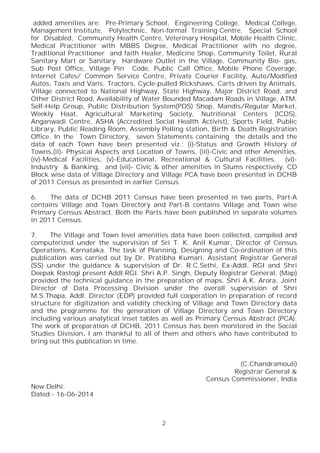


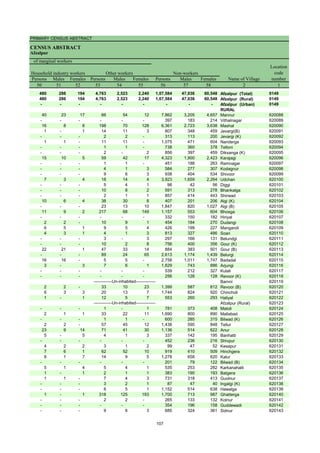

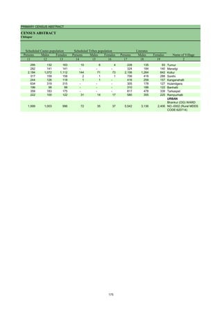
![DISTRICT CENSUS HANDBOOK : GULBARGA
VILLAGE PRIMARY
Persons Males Females Persons Males Females
1 2 3 4 5 6 7 8 9 10
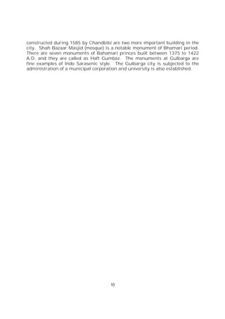
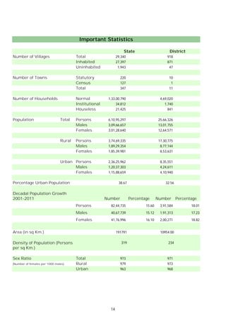
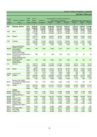
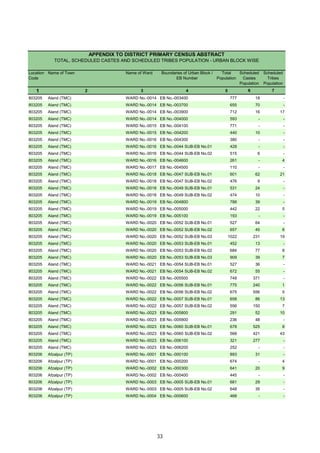
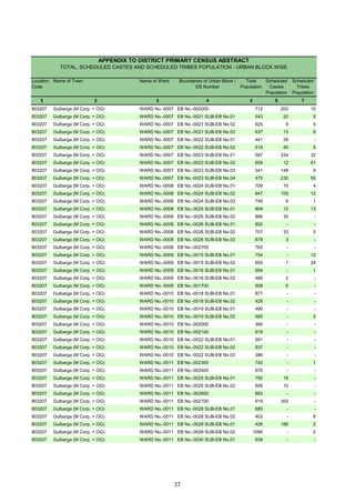
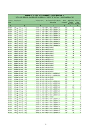
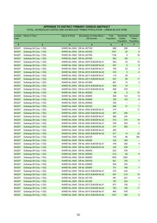
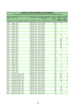
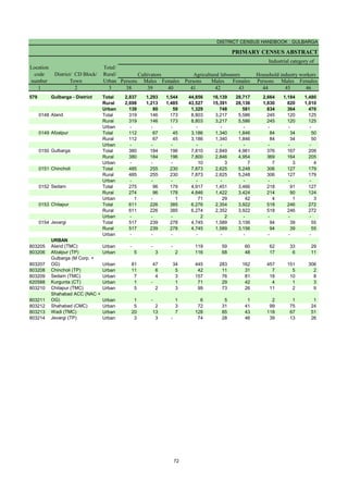
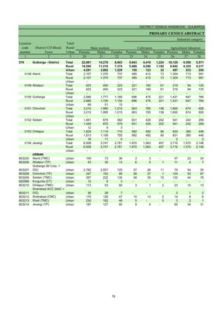
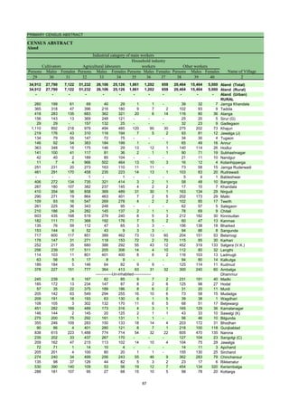
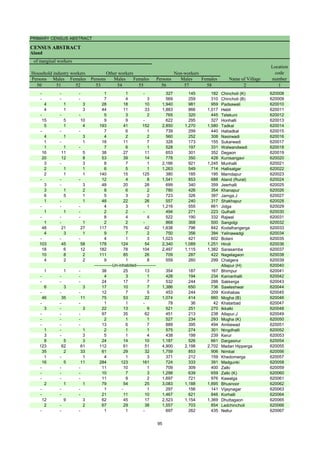
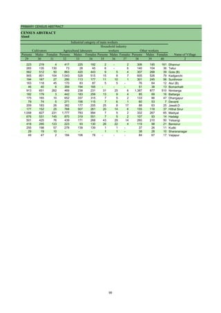
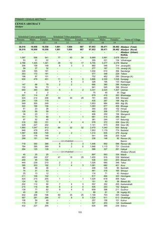
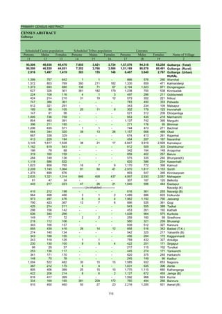
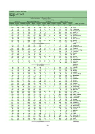
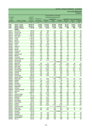
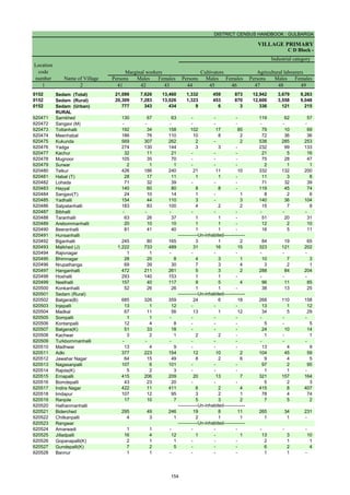
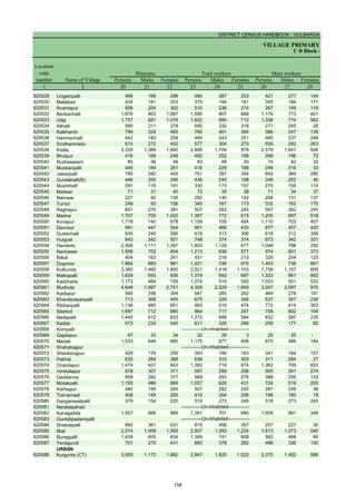
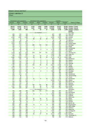
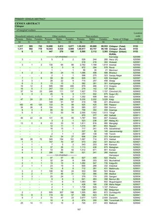
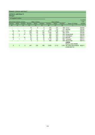
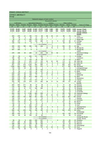
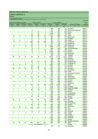
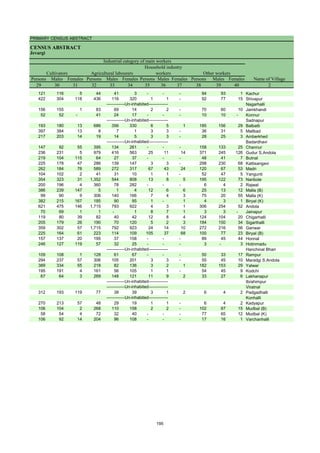
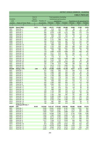
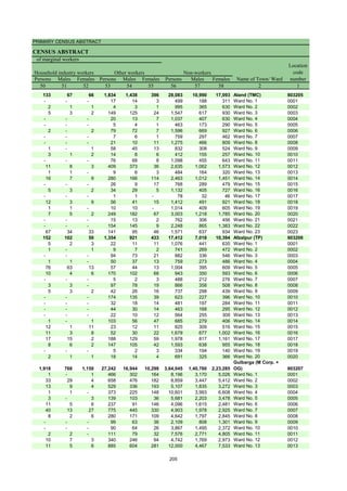
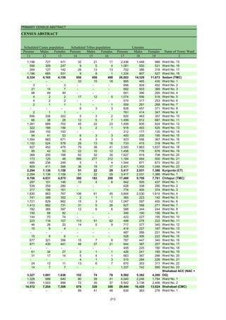
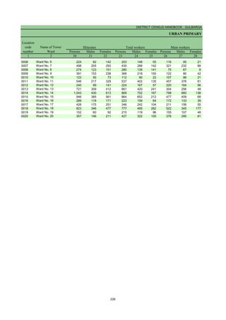
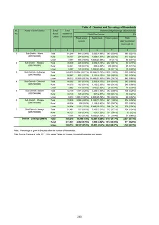
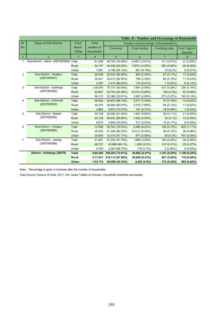
0151 Chincholi (Total) 1,53,673.16 44,466 2,33,390 1,16,896 1,16,494 33,518 17,139 16,379
0151 Chincholi (Rural) 1,53,673.16 44,466 2,33,390 1,16,896 1,16,494 33,518 17,139 16,379
0151 Chincholi (Urban) 0.00 - - - - - - -
RURAL
620323 Chengta 3,677.62 1,075 5,873 3,017 2,856 921 447 474
620324 Bhunyar[B] 733.04 173 838 421 417 117 53 64
620325 Bhunyar[K] 1,351.51 415 2,138 1,080 1,058 414 198 216
620326 Khanapur 986.97 424 2,031 1,005 1,026 299 144 155
620327 Ainapur 2,481.32 654 3,502 1,746 1,756 431 223 208
620328 Benkeppalli 1,928.72 631 3,522 1,830 1,692 593 311 282
620329 Salgar Basanthpur 1,358.11 641 3,605 1,820 1,785 585 301 284
620330 Yetabarpur 1,471.42 304 1,780 929 851 353 217 136
620331 Salebeernhalli 2,167.81 578 3,203 1,588 1,615 479 239 240
620332 Tumkunta 1,002.20 446 2,399 1,223 1,176 376 194 182
620333 Hasargundgi 1,072.88 498 2,364 1,177 1,187 276 141 135
620334 Gurampalli 517.55 109 509 231 278 81 38 43
620335 Nagarhal 391.46 100 543 285 258 68 34 34
620336 Yalmamdi 1,460.69 399 2,225 1,123 1,102 341 171 170
620337 Channur 709.64 166 1,010 515 495 129 56 73
620338 Gadilingdhalli 1,593.67 574 3,462 1,768 1,694 573 307 266
620339 Kotga 1,228.96 297 1,611 808 803 204 107 97
620340 Dhuttarga 828.58 148 896 455 441 118 59 59
620341 Gongi 187.02 38 212 106 106 21 9 12
620342 Pangarga 1,048.74 181 1,065 533 532 154 79 75
620343 Chandankera 3,779.93 887 5,049 2,603 2,446 785 416 369
620344 Ranapur 616.42 271 1,426 717 709 245 121 124
620345 Sasargaon 857.57 256 1,362 675 687 244 132 112
620346 Narnal 1,010.87 302 1,494 732 762 178 89 89
620347 Chimmanchod 3,448.04 1,085 5,988 3,049 2,939 865 471 394
620348 Tajlapur 488.89 205 890 480 410 118 67 51
620349 Marpalli 1,212.14 398 2,003 1,027 976 282 151 131
620350 Shikarm0Takpalli 526.19 156 783 397 386 88 43 45
620351 Yempalli 663.51 231 1,269 638 631 165 75 90
620352 Garampalli 1,607.24 438 2,189 1,082 1,107 361 194 167
620353 Tirmalapur 204.81 59 296 150 146 41 25 16
620354 Kusrampalli 600.27 230 1,182 612 570 165 88 77
620355 Manikpur 598.44
620356 Gottamgotta[K] * 24.79
620357 Gottamgotta 787.12 1 12 4 8 4 1 3
620358 Sangapur 681.44 191 1,057 528 529 210 114 96
620359 Katangidda 175.99
620360 Srinagar 700.24 244 1,316 658 658 252 138 114
620361 Venkatapur 1,308.95 470 2,474 1,251 1,223 362 180 182
620362 Dharmasagar 994.13 334 1,890 982 908 315 178 137
620363 Chandrampalli 1,035.19 224 1,070 547 523 163 84 79
620364 Kollur 1,735.08 413 1,999 989 1,010 211 103 108
620365 Nagaidlai 1,404.93 493 2,768 1,416 1,352 415 192 223
620366 Patpalli 464.05 178 860 440 420 83 42 41
620367 Degalmadi 1,585.50 708 3,339 1,657 1,682 370 177 193
620368 Fathepur 202.14 139 615 283 332 77 33 44
620369 Ainoli 2,819.50 1,077 5,363 2,693 2,670 664 339 325
620370 Bhikkanhalli 1,227.16
620371 Burugdoddi 1,275.95
620372 Antwaram 853.16 132 621 308 313 69 36 33
620373 Linganagar 890.69 61 284 149 135 38 17 21
620374 Bhonaspur 443.14 177 864 438 426 128 75 53
620375 Shivrampur 548.20 202 959 472 487 97 48 49
620376 Magdampur 1,226.45 300 1,563 802 761 213 113 100
620377 Shivredpalli 254.87 127 544 274 270 57 30 27
620378 Konchawaram 408.66 786 3,776 1,952 1,824 425 210 215
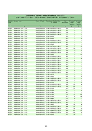
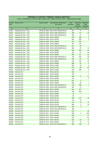
Name of Village
Location
code
number
Total population (including
institutional and houseless
population)
Area of
Village in
hectares
Number of
households
C D Block -
Population in the age-group 0-6
-------------Un-inhabited--------------
-------------Un-inhabited--------------
-------------Un-inhabited--------------
-------------Un-inhabited--------------
-------------Un-inhabited--------------
132](https://image.slidesharecdn.com/gulbrgahistory-211108111456/85/Gulbrga-history-147-320.jpg)
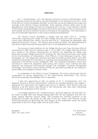
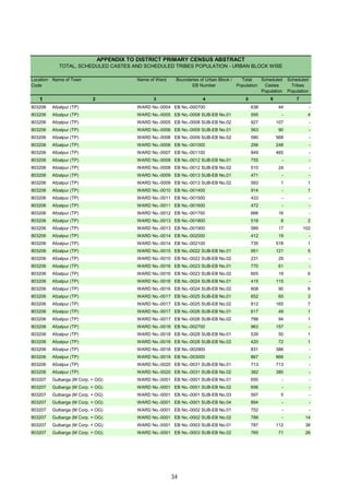
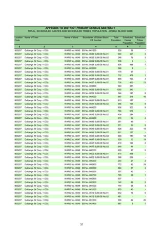
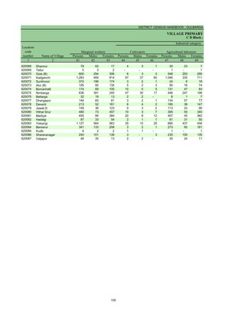
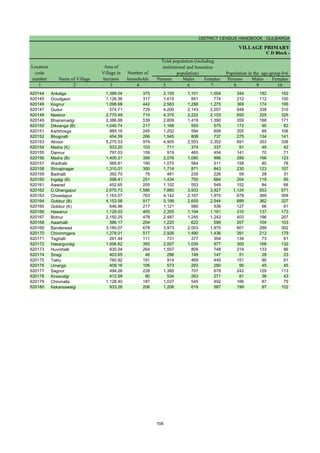
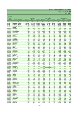
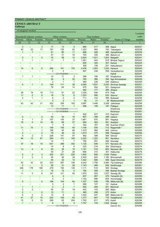
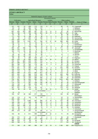
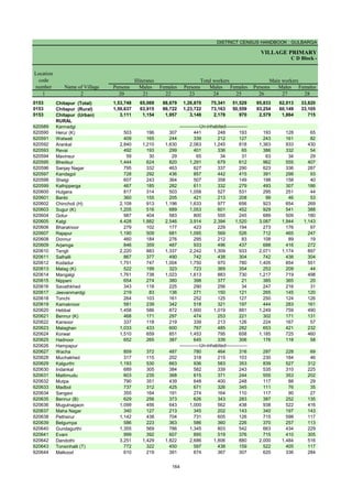
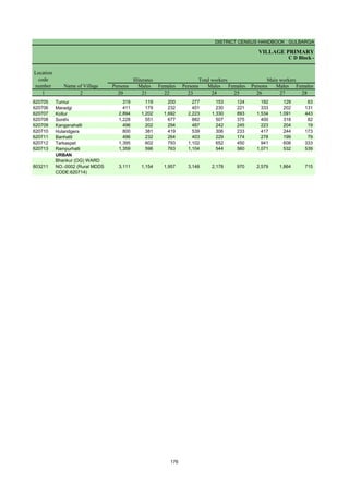
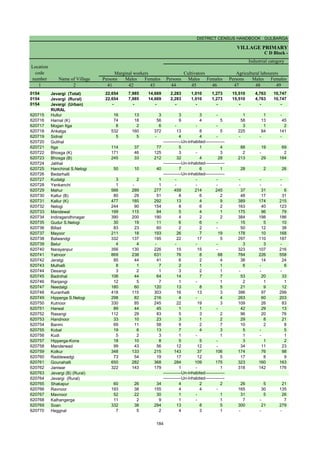
![PRIMARY CENSUS ABSTRACT
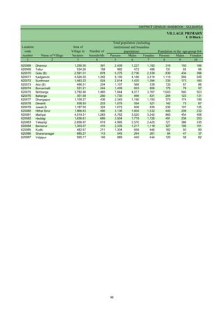
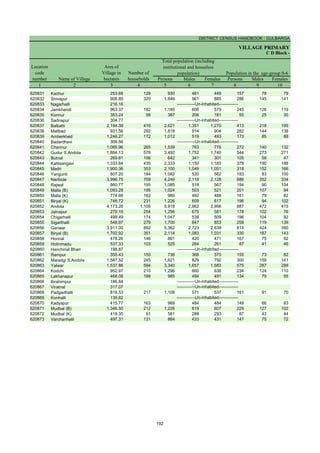
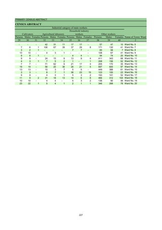
CENSUS ABSTRACT
Chincholi
Persons Males Females Persons Males Females Persons Males Females
11 12 13 14 15 16 17 18 19 2
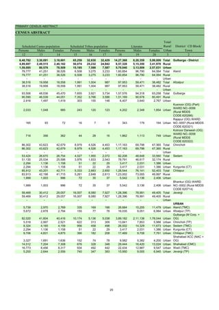
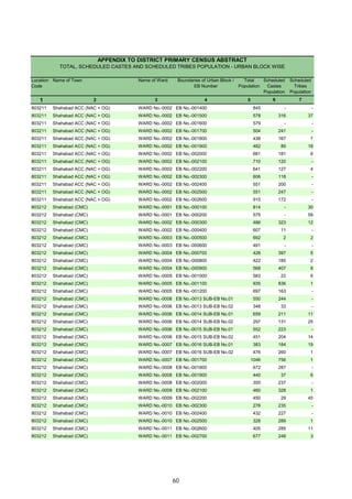
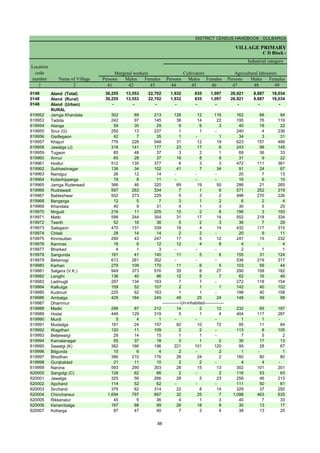
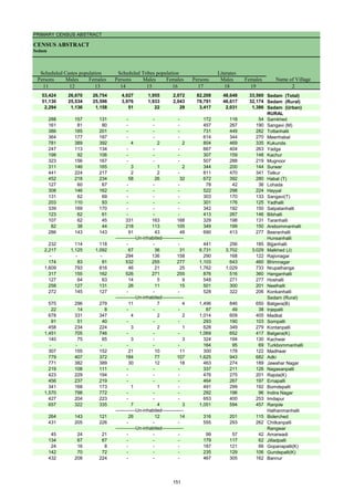
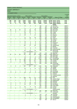
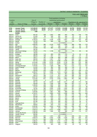
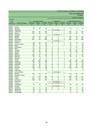
86,302 43,623 42,679 8,979 4,526 4,453 1,17,163 69,798 47,365 Chincholi (Total)
86,302 43,623 42,679 8,979 4,526 4,453 1,17,163 69,798 47,365 Chincholi (Rural)
- - - - - - - - - Chincholi (Urban)
RURAL
2,895 1,475 1,420 573 297 276 2,925 1,739 1,186 Chengta
68 35 33 - - - 523 317 206 Bhunyar[B]
1,768 901 867 2 2 - 851 541 310 Bhunyar[K]
1,219 621 598 2 1 1 946 569 377 Khanapur
391 224 167 68 33 35 2,023 1,163 860 Ainapur
2,238 1,175 1,063 86 44 42 1,623 1,044 579 Benkeppalli
3,095 1,574 1,521 76 41 35 1,301 842 459 Salgar Basanthpur
1,770 922 848 2 2 - 470 322 148 Yetabarpur
1,271 647 624 113 53 60 1,398 845 553 Salebeernhalli
1,382 715 667 339 167 172 992 623 369 Tumkunta
575 291 284 24 13 11 1,287 758 529 Hasargundgi
184 80 104 - - - 206 117 89 Gurampalli
79 45 34 7 4 3 367 222 145 Nagarhal
961 485 476 42 19 23 979 595 384 Yalmamdi
362 183 179 1 1 - 534 327 207 Channur
2,221 1,158 1,063 16 6 10 1,584 996 588 Gadilingdhalli
147 77 70 8 5 3 774 447 327 Kotga
417 216 201 2 2 - 435 272 163 Dhuttarga
93 46 47 - - - 157 90 67 Gongi
211 112 99 - - - 544 328 216 Pangarga
2,653 1,384 1,269 218 102 116 2,383 1,448 935 Chandankera
895 443 452 - - - 506 315 191 Ranapur
605 302 303 2 1 1 571 325 246 Sasargaon
265 121 144 10 5 5 775 457 318 Narnal
2,450 1,290 1,160 34 14 20 3,324 2,003 1,321 Chimmanchod
190 95 95 2 1 1 496 321 175 Tajlapur
305 152 153 11 5 6 937 583 354 Marpalli
193 99 94 19 9 10 498 295 203 Shikarm0Takpalli
213 107 106 343 171 172 715 429 286 Yempalli
539 270 269 66 34 32 1,063 601 462 Garampalli
75 42 33 147 71 76 173 99 74 Tirmalapur
852 426 426 - - - 620 394 226 Kusrampalli
Manikpur
Gottamgotta[K] *
- - - - - - 3 1 2 Gottamgotta
1,048 524 524 - - - 304 203 101 Sangapur
Katangidda
1,309 656 653 - - - 478 315 163 Srinagar
1,569 798 771 24 14 10 859 565 294 Venkatapur
1,884 977 907 2 2 - 612 412 200 Dharmasagar
252 132 120 28 14 14 555 332 223 Chandrampalli
435 213 222 13 4 9 1,100 656 444 Kollur
550 279 271 104 53 51 1,533 921 612 Nagaidlai
213 111 102 36 17 19 475 292 183 Patpalli
702 352 350 374 183 191 1,964 1,147 817 Degalmadi
45 21 24 3 - 3 313 160 153 Fathepur
1,179 592 587 287 156 131 3,111 1,822 1,289 Ainoli
Bhikkanhalli
Burugdoddi
346 169 177 59 32 27 260 165 95 Antwaram
284 149 135 - - - 111 72 39 Linganagar
315 157 158 93 45 48 363 199 164 Bhonaspur
424 209 215 - - - 516 289 227 Shivrampur
741 381 360 6 4 2 727 422 305 Magdampur
419 212 207 - - - 265 152 113 Shivredpalli
1,563 807 756 18 9 9 2,075 1,312 763 Konchawaram
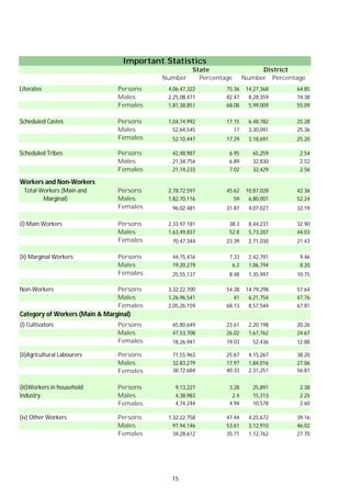
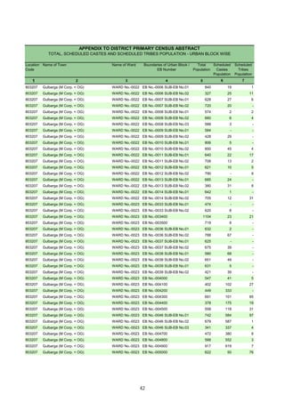
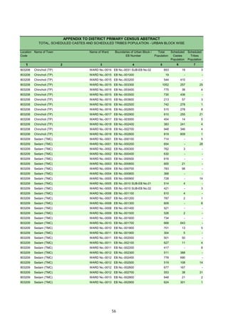
Name of Village
Literates
Scheduled Castes population Scheduled Tribes population
-------------Un-inhabited--------------
-------------Un-inhabited--------------
-------------Un-inhabited--------------
-------------Un-inhabited--------------
-------------Un-inhabited--------------
133](https://image.slidesharecdn.com/gulbrgahistory-211108111456/85/Gulbrga-history-148-320.jpg)
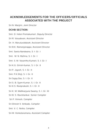
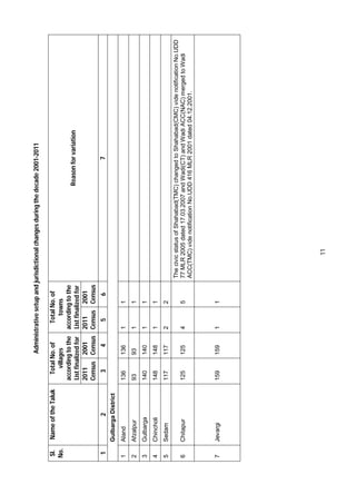
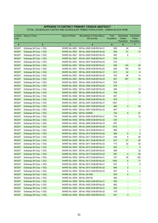
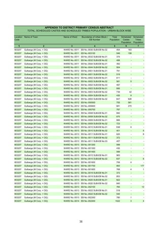
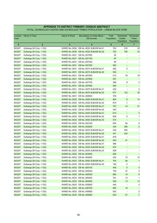
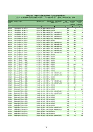
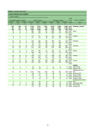
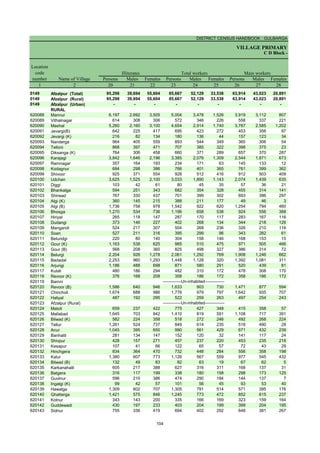
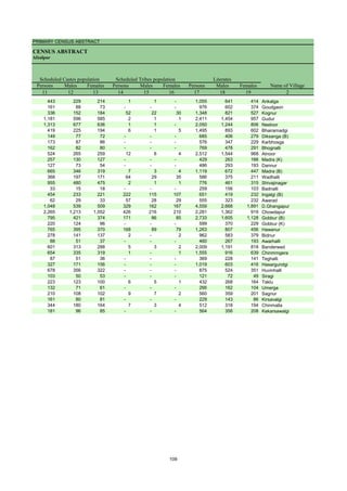
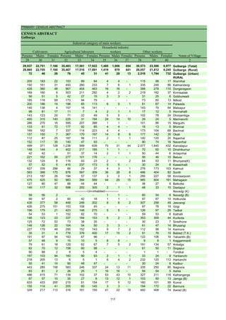
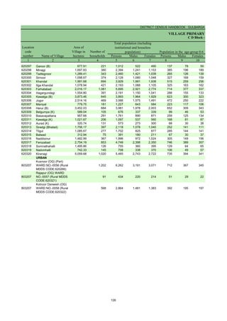
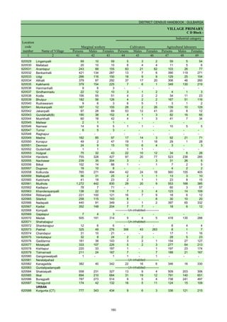
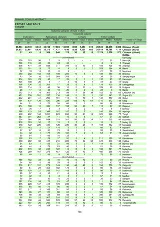
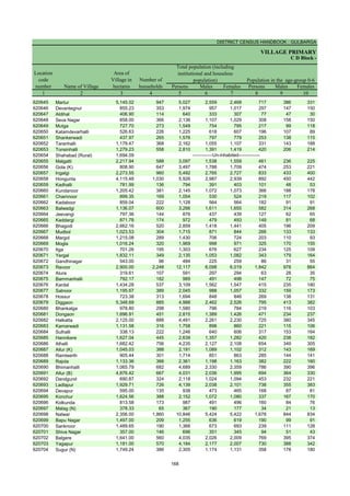
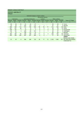
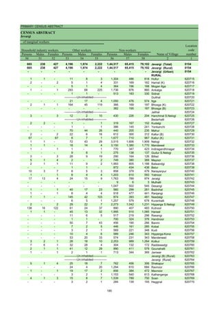
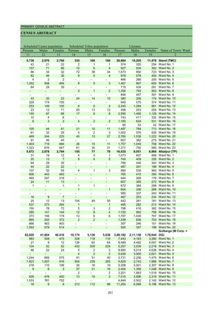
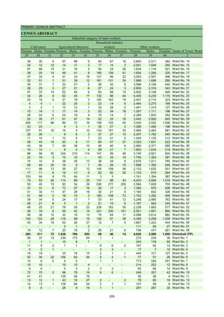
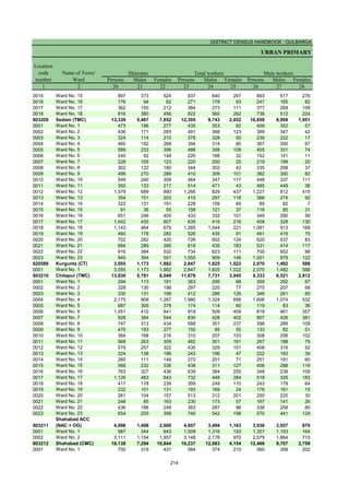
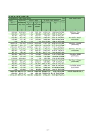
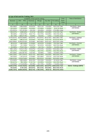
![DISTRICT CENSUS HANDBOOK : GULBARGA
VILLAGE PRIMARY
C D Block -
Persons Males Females Persons Males Females Persons Males Females
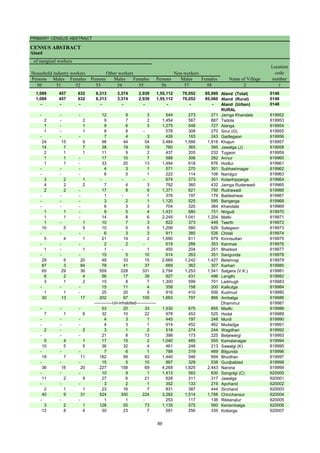
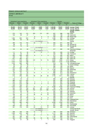
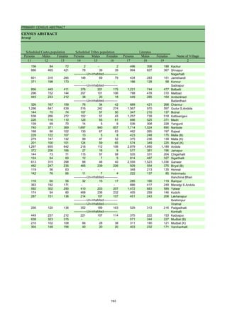
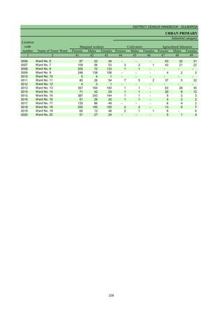
1 2 20 21 22 23 24 25 26 27 28
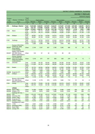
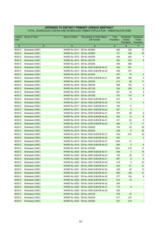
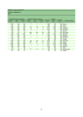
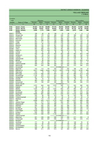
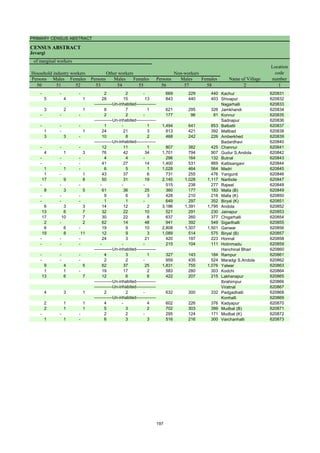
0151 Chincholi (Total) 1,16,227 47,098 69,129 1,13,495 64,155 49,340 88,506 54,326 34,180
0151 Chincholi (Rural) 1,16,227 47,098 69,129 1,13,495 64,155 49,340 88,506 54,326 34,180
0151 Chincholi (Urban) - - - - - - - - -
RURAL
620323 Chengta 2,948 1,278 1,670 2,983 1,652 1,331 2,129 1,421 708
620324 Bhunyar[B] 315 104 211 391 240 151 272 161 111
620325 Bhunyar[K] 1,287 539 748 996 553 443 683 490 193
620326 Khanapur 1,085 436 649 890 506 384 693 401 292
620327 Ainapur 1,479 583 896 1,631 907 724 1,380 847 533
620328 Benkeppalli 1,899 786 1,113 1,878 957 921 1,584 870 714
620329 Salgar Basanthpur 2,304 978 1,326 1,739 972 767 1,111 730 381
620330 Yetabarpur 1,310 607 703 937 495 442 652 391 261
620331 Salebeernhalli 1,805 743 1,062 1,593 918 675 1,424 872 552
620332 Tumkunta 1,407 600 807 1,421 728 693 1,051 559 492
620333 Hasargundgi 1,077 419 658 934 643 291 785 566 219
620334 Gurampalli 303 114 189 186 129 57 133 104 29
620335 Nagarhal 176 63 113 307 155 152 227 138 89
620336 Yalmamdi 1,246 528 718 1,298 639 659 856 425 431
620337 Channur 476 188 288 469 289 180 148 147 1
620338 Gadilingdhalli 1,878 772 1,106 1,661 871 790 1,250 796 454
620339 Kotga 837 361 476 1,040 528 512 798 494 304
620340 Dhuttarga 461 183 278 367 261 106 291 223 68
620341 Gongi 55 16 39 121 62 59 27 26 1
620342 Pangarga 521 205 316 547 281 266 393 263 130
620343 Chandankera 2,666 1,155 1,511 2,463 1,371 1,092 1,002 704 298
620344 Ranapur 920 402 518 778 410 368 611 364 247
620345 Sasargaon 791 350 441 652 347 305 647 344 303
620346 Narnal 719 275 444 824 402 422 602 348 254
620347 Chimmanchod 2,664 1,046 1,618 2,778 1,575 1,203 2,530 1,504 1,026
620348 Tajlapur 394 159 235 531 288 243 377 217 160
620349 Marpalli 1,066 444 622 950 543 407 931 534 397
620350 Shikarm0Takpalli 285 102 183 275 208 67 265 202 63
620351 Yempalli 554 209 345 475 340 135 452 331 121
620352 Garampalli 1,126 481 645 1,219 603 616 1,211 600 611
620353 Tirmalapur 123 51 72 162 73 89 2 1 1
620354 Kusrampalli 562 218 344 721 376 345 58 48 10
620355 Manikpur
620356 Gottamgotta[K] *
620357 Gottamgotta 9 3 6 2 2 - 2 2 -
620358 Sangapur 753 325 428 575 269 306 411 243 168
620359 Katangidda
620360 Srinagar 838 343 495 657 322 335 427 226 201
620361 Venkatapur 1,615 686 929 1,372 702 670 1,251 661 590
620362 Dharmasagar 1,278 570 708 1,114 586 528 761 437 324
620363 Chandrampalli 515 215 300 514 290 224 491 271 220
620364 Kollur 899 333 566 1,091 596 495 451 319 132
620365 Nagaidlai 1,235 495 740 1,103 765 338 552 474 78
620366 Patpalli 385 148 237 397 250 147 392 245 147
620367 Degalmadi 1,375 510 865 1,795 977 818 1,452 862 590
620368 Fathepur 302 123 179 159 98 61 103 67 36
620369 Ainoli 2,252 871 1,381 2,417 1,518 899 2,272 1,442 830
620370 Bhikkanhalli
620371 Burugdoddi
620372 Antwaram 361 143 218 399 205 194 393 203 190
620373 Linganagar 173 77 96 196 97 99 183 89 94
620374 Bhonaspur 501 239 262 431 220 211 422 213 209
620375 Shivrampur 443 183 260 550 281 269 521 262 259
620376 Magdampur 836 380 456 751 453 298 732 444 288
620377 Shivredpalli 279 122 157 335 183 152 158 146 12
620378 Konchawaram 1,701 640 1,061 2,019 1,113 906 1,945 1,074 871
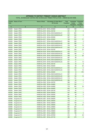
Name of Village
Location
code
number
Illiterates Total workers Main workers
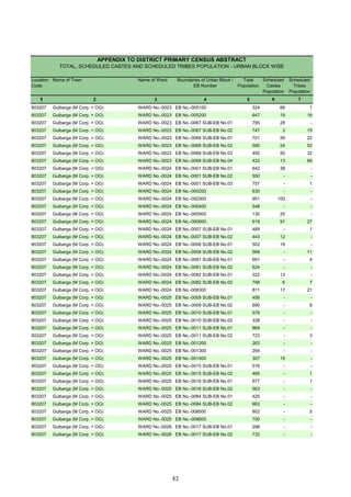
-------------Un-inhabited--------------
-------------Un-inhabited--------------
-------------Un-inhabited--------------
-------------Un-inhabited--------------
-------------Un-inhabited--------------
134](https://image.slidesharecdn.com/gulbrgahistory-211108111456/85/Gulbrga-history-149-320.jpg)
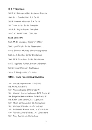
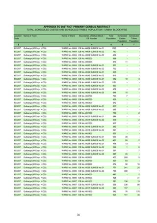
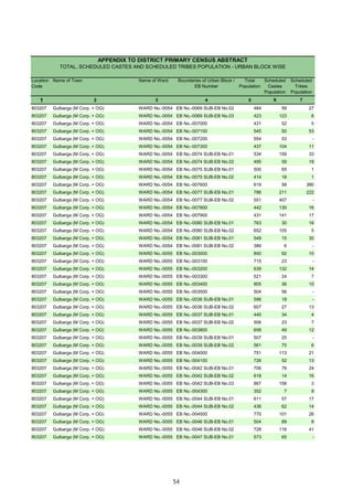
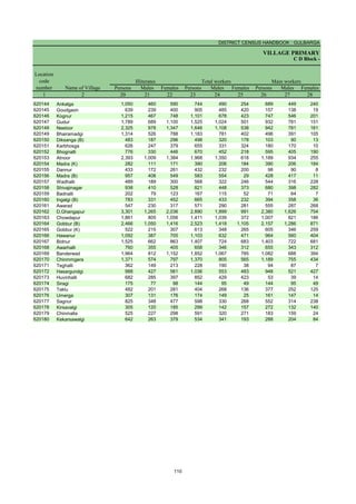
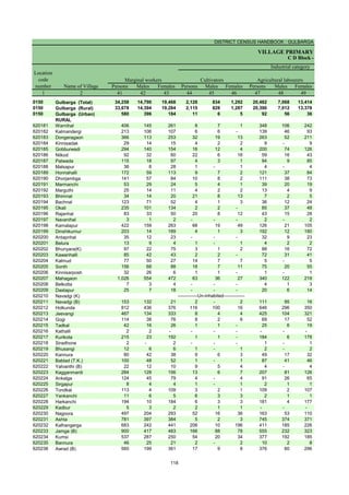
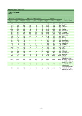
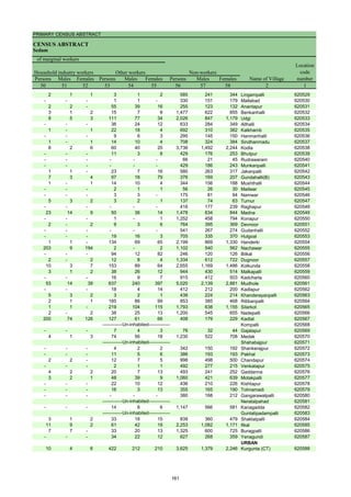
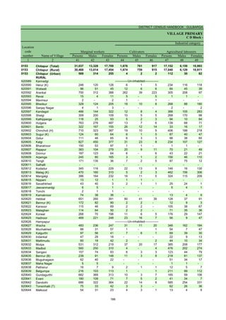
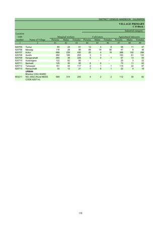
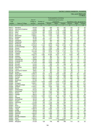
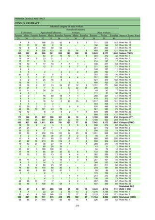
![PRIMARY CENSUS ABSTRACT
CENSUS ABSTRACT
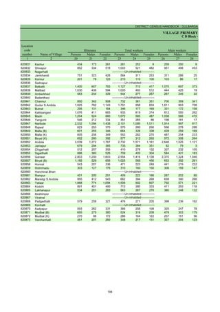
Chincholi
Persons Males Females Persons Males Females Persons Males Females Persons Males Females
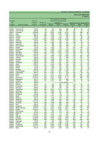
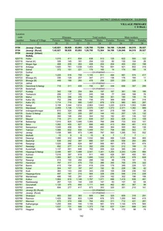
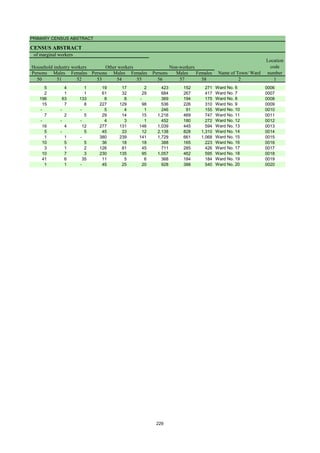
29 30 31 32 33 34 35 36 37 38 39 40 2
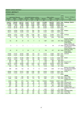
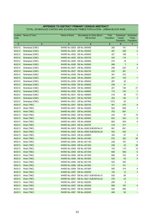
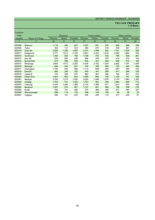
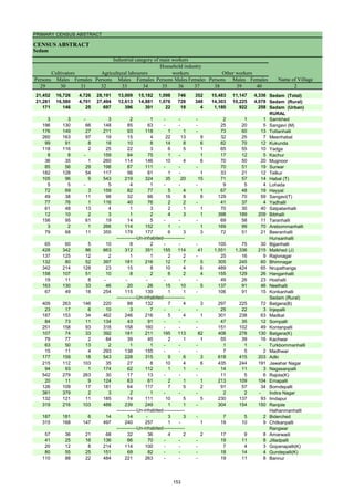
25,233 19,527 5,706 44,669 21,227 23,442 1,089 718 371 17,515 12,854 4,661 Chincholi (Total)
25,233 19,527 5,706 44,669 21,227 23,442 1,089 718 371 17,515 12,854 4,661 Chincholi (Rural)
- - - - - - - - - - - - Chincholi (Urban)
RURAL
539 475 64 629 262 367 12 6 6 949 678 271 Chengta
100 100 - 109 12 97 1 1 - 62 48 14 Bhunyar[B]
239 239 - 369 194 175 3 3 - 72 54 18 Bhunyar[K]
125 118 7 511 260 251 8 1 7 49 22 27 Khanapur
338 256 82 754 386 368 7 4 3 281 201 80 Ainapur
647 350 297 744 391 353 55 40 15 138 89 49 Benkeppalli
775 501 274 154 86 68 19 17 2 163 126 37 Salgar Basanthpur
349 290 59 193 75 118 1 - 1 109 26 83 Yetabarpur
321 268 53 767 420 347 8 5 3 328 179 149 Salebeernhalli
151 108 43 832 394 438 - - - 68 57 11 Tumkunta
102 96 6 467 296 171 30 24 6 186 150 36 Hasargundgi
33 30 3 75 54 21 2 2 - 23 18 5 Gurampalli
37 31 6 161 88 73 13 8 5 16 11 5 Nagarhal
254 157 97 348 200 148 19 10 9 235 58 177 Yalmamdi
132 132 - 4 4 - - - - 12 11 1 Channur
501 462 39 608 244 364 4 3 1 137 87 50 Gadilingdhalli
761 470 291 18 10 8 5 4 1 14 10 4 Kotga
127 102 25 101 78 23 5 5 - 58 38 20 Dhuttarga
19 19 - 3 2 1 - - - 5 5 - Gongi
212 191 21 164 59 105 - - - 17 13 4 Pangarga
250 242 8 560 299 261 10 10 - 182 153 29 Chandankera
147 123 24 363 162 201 - - - 101 79 22 Ranapur
145 144 1 326 90 236 - - - 176 110 66 Sasargaon
228 220 8 286 55 231 1 1 - 87 72 15 Narnal
444 380 64 1,566 690 876 29 18 11 491 416 75 Chimmanchod
127 111 16 57 35 22 6 4 2 187 67 120 Tajlapur
85 79 6 759 378 381 23 21 2 64 56 8 Marpalli
77 72 5 156 100 56 2 2 - 30 28 2 Shikarm0Takpalli
266 249 17 145 54 91 - - - 41 28 13 Yempalli
7 6 1 1,186 580 606 2 1 1 16 13 3 Garampalli
- - - - - - - - - 2 1 1 Tirmalapur
18 17 1 18 14 4 3 3 - 19 14 5 Kusrampalli
Manikpur
Gottamgotta[K] *
- - - - - - - - - 2 2 - Gottamgotta
316 194 122 40 19 21 5 2 3 50 28 22 Sangapur
Katangidda
203 96 107 109 42 67 22 17 5 93 71 22 Srinagar
673 476 197 509 128 381 - - - 69 57 12 Venkatapur
268 250 18 431 153 278 11 7 4 51 27 24 Dharmasagar
140 89 51 308 150 158 2 1 1 41 31 10 Chandrampalli
130 100 30 289 199 90 4 2 2 28 18 10 Kollur
246 234 12 140 101 39 12 9 3 154 130 24 Nagaidlai
70 70 - 279 141 138 - - - 43 34 9 Patpalli
283 195 88 1,005 528 477 10 6 4 154 133 21 Degalmadi
42 35 7 22 11 11 7 6 1 32 15 17 Fathepur
382 310 72 1,444 751 693 4 1 3 442 380 62 Ainoli
Bhikkanhalli
Burugdoddi
86 74 12 294 122 172 1 1 - 12 6 6 Antwaram
18 18 - 161 70 91 - - - 4 1 3 Linganagar
209 104 105 173 78 95 - - - 40 31 9 Bhonaspur
143 81 62 364 173 191 - - - 14 8 6 Shivrampur
252 196 56 396 182 214 - - - 84 66 18 Magdampur
94 90 4 32 28 4 - - - 32 28 4 Shivredpalli
204 134 70 1,220 576 644 74 35 39 447 329 118 Konchawaram
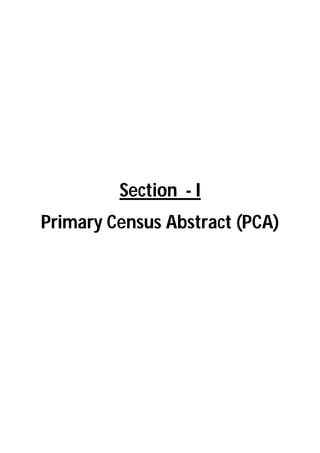
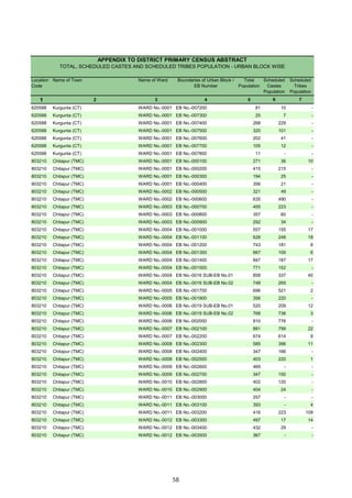
Cultivators
Name of Village
Household industry
workers
Agricultural labourers
Industrial category of main workers
Other workers
-------------Un-inhabited--------------
-------------Un-inhabited--------------
-------------Un-inhabited--------------
-------------Un-inhabited--------------
-------------Un-inhabited--------------
135](https://image.slidesharecdn.com/gulbrgahistory-211108111456/85/Gulbrga-history-150-320.jpg)
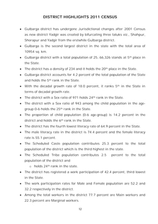
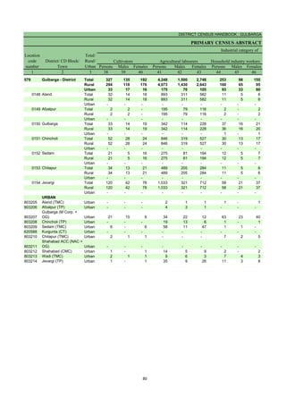
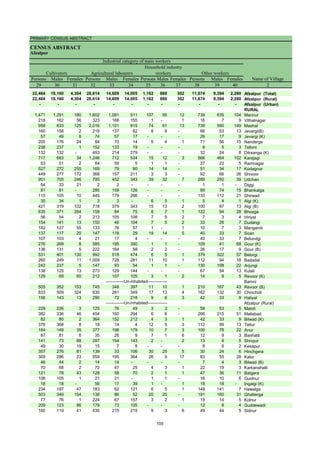
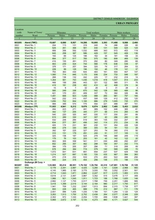
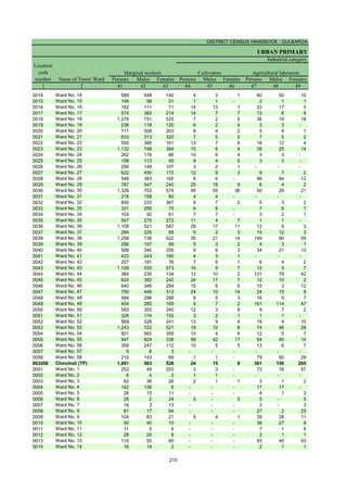
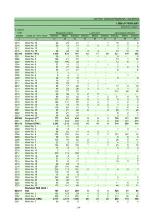
![DISTRICT CENSUS HANDBOOK : GULBARGA
VILLAGE PRIMARY
C D Block -
Persons Males Females Persons Males Females Persons Males Females
1 2 41 42 43 44 45 46 47 48 49
0151 Chincholi (Total) 24,989 9,829 15,160 1,402 639 763 17,246 5,999 11,247
0151 Chincholi (Rural) 24,989 9,829 15,160 1,402 639 763 17,246 5,999 11,247
0151 Chincholi (Urban) - - - - - - - - -
RURAL
620323 Chengta 854 231 623 26 18 8 679 180 499
620324 Bhunyar[B] 119 79 40 - - - 8 1 7
620325 Bhunyar[K] 313 63 250 2 2 - 284 43 241
620326 Khanapur 197 105 92 12 11 1 120 57 63
620327 Ainapur 251 60 191 9 6 3 78 32 46
620328 Benkeppalli 294 87 207 19 7 12 152 45 107
620329 Salgar Basanthpur 628 242 386 102 63 39 419 132 287
620330 Yetabarpur 285 104 181 4 2 2 228 74 154
620331 Salebeernhalli 169 46 123 28 7 21 103 19 84
620332 Tumkunta 370 169 201 3 - 3 311 132 179
620333 Hasargundgi 149 77 72 11 6 5 50 22 28
620334 Gurampalli 53 25 28 7 4 3 31 13 18
620335 Nagarhal 80 17 63 1 1 - 74 14 60
620336 Yalmamdi 442 214 228 4 1 3 429 210 219
620337 Channur 321 142 179 11 10 1 137 130 7
620338 Gadilingdhalli 411 75 336 4 3 1 350 66 284
620339 Kotga 242 34 208 12 4 8 208 21 187
620340 Dhuttarga 76 38 38 3 2 1 40 10 30
620341 Gongi 94 36 58 - - - 74 17 57
620342 Pangarga 154 18 136 12 2 10 128 5 123
620343 Chandankera 1,461 667 794 42 30 12 1,361 609 752
620344 Ranapur 167 46 121 11 8 3 141 28 113
620345 Sasargaon 5 3 2 1 1 - 1 - 1
620346 Narnal 222 54 168 - - - 86 23 63
620347 Chimmanchod 248 71 177 6 1 5 210 53 157
620348 Tajlapur 154 71 83 2 1 1 13 2 11
620349 Marpalli 19 9 10 - - - 17 7 10
620350 Shikarm0Takpalli 10 6 4 2 - 2 5 3 2
620351 Yempalli 23 9 14 4 3 1 9 3 6
620352 Garampalli 8 3 5 - - - 5 1 4
620353 Tirmalapur 160 72 88 10 8 2 17 15 2
620354 Kusrampalli 663 328 335 42 22 20 570 268 302
620355 Manikpur
620356 Gottamgotta[K] *
620357 Gottamgotta - - - - - - - - -
620358 Sangapur 164 26 138 1 - 1 52 10 42
620359 Katangidda
620360 Srinagar 230 96 134 9 3 6 170 68 102
620361 Venkatapur 121 41 80 32 7 25 84 32 52
620362 Dharmasagar 353 149 204 34 27 7 277 102 175
620363 Chandrampalli 23 19 4 2 1 1 2 2 -
620364 Kollur 640 277 363 101 42 59 511 216 295
620365 Nagaidlai 551 291 260 17 11 6 110 66 44
620366 Patpalli 5 5 - - - - 2 2 -
620367 Degalmadi 343 115 228 22 2 20 250 68 182
620368 Fathepur 56 31 25 14 8 6 1 1 -
620369 Ainoli 145 76 69 - - - 67 18 49
620370 Bhikkanhalli
620371 Burugdoddi
620372 Antwaram 6 2 4 1 1 - 5 1 4
620373 Linganagar 13 8 5 - - - 7 4 3
620374 Bhonaspur 9 7 2 1 1 - 1 - 1
620375 Shivrampur 29 19 10 1 1 - 26 17 9
620376 Magdampur 19 9 10 7 2 5 5 3 2
620377 Shivredpalli 177 37 140 45 17 28 132 20 112
620378 Konchawaram 74 39 35 1 - 1 22 14 8
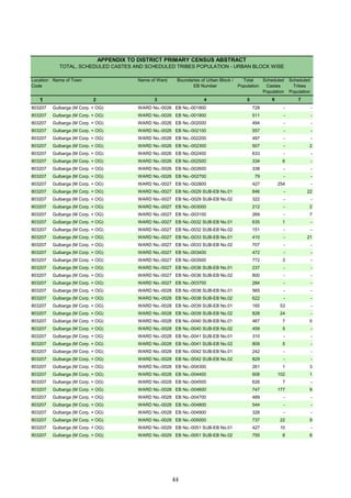
Name of Village
Marginal workers Cultivators Agricultural labourers
Industrial category
Location
code
number
-------------Un-inhabited--------------
-------------Un-inhabited--------------
-------------Un-inhabited--------------
-------------Un-inhabited--------------
-------------Un-inhabited--------------
136](https://image.slidesharecdn.com/gulbrgahistory-211108111456/85/Gulbrga-history-151-320.jpg)
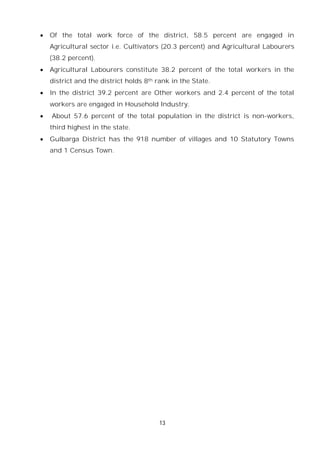
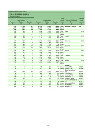
![PRIMARY CENSUS ABSTRACT
CENSUS ABSTRACT
Chincholi
Persons Males Females Persons Males Females Persons Males Females
50 51 52 53 54 55 56 57 58 2 1
795 340 455 5,546 2,851 2,695 1,19,895 52,741 67,154 Chincholi (Total) 0151
795 340 455 5,546 2,851 2,695 1,19,895 52,741 67,154 Chincholi (Rural) 0151
- - - - - - - - - Chincholi (Urban) 0151
RURAL
1 - 1 148 33 115 2,890 1,365 1,525 Chengta 620323
1 - 1 110 78 32 447 181 266 Bhunyar[B] 620324
2 1 1 25 17 8 1,142 527 615 Bhunyar[K] 620325
2 - 2 63 37 26 1,141 499 642 Khanapur 620326
3 - 3 161 22 139 1,871 839 1,032 Ainapur 620327
16 3 13 107 32 75 1,644 873 771 Benkeppalli 620328
13 6 7 94 41 53 1,866 848 1,018 Salgar Basanthpur 620329
- - - 53 28 25 843 434 409 Yetabarpur 620330
1 1 - 37 19 18 1,610 670 940 Salebeernhalli 620331
15 8 7 41 29 12 978 495 483 Tumkunta 620332
69 32 37 19 17 2 1,430 534 896 Hasargundgi 620333
1 - 1 14 8 6 323 102 221 Gurampalli 620334
4 1 3 1 1 - 236 130 106 Nagarhal 620335
- - - 9 3 6 927 484 443 Yalmamdi 620336
- - - 173 2 171 541 226 315 Channur 620337
16 - 16 41 6 35 1,801 897 904 Gadilingdhalli 620338
6 2 4 16 7 9 571 280 291 Kotga 620339
- - - 33 26 7 529 194 335 Dhuttarga 620340
- - - 20 19 1 91 44 47 Gongi 620341
2 2 - 12 9 3 518 252 266 Pangarga 620342
5 2 3 53 26 27 2,586 1,232 1,354 Chandankera 620343
1 - 1 14 10 4 648 307 341 Ranapur 620344
- - - 3 2 1 710 328 382 Sasargaon 620345
- - - 136 31 105 670 330 340 Narnal 620346
2 - 2 30 17 13 3,210 1,474 1,736 Chimmanchod 620347
- - - 139 68 71 359 192 167 Tajlapur 620348
- - - 2 2 - 1,053 484 569 Marpalli 620349
1 1 - 2 2 - 508 189 319 Shikarm0Takpalli 620350
- - - 10 3 7 794 298 496 Yempalli 620351
- - - 3 2 1 970 479 491 Garampalli 620352
5 2 3 128 47 81 134 77 57 Tirmalapur 620353
4 3 1 47 35 12 461 236 225 Kusrampalli 620354
Manikpur 620355
Gottamgotta[K] * 620356
- - - - - - 10 2 8 Gottamgotta 620357
20 3 17 91 13 78 482 259 223 Sangapur 620358
Katangidda 620359
- - - 51 25 26 659 336 323 Srinagar 620360
- - - 5 2 3 1,102 549 553 Venkatapur 620361
7 4 3 35 16 19 776 396 380 Dharmasagar 620362
2 2 - 17 14 3 556 257 299 Chandrampalli 620363
16 10 6 12 9 3 908 393 515 Kollur 620364
13 6 7 411 208 203 1,665 651 1,014 Nagaidlai 620365
- - - 3 3 - 463 190 273 Patpalli 620366
10 4 6 61 41 20 1,544 680 864 Degalmadi 620367
4 2 2 37 20 17 456 185 271 Fathepur 620368
5 2 3 73 56 17 2,946 1,175 1,771 Ainoli 620369
Bhikkanhalli 620370
Burugdoddi 620371
- - - - - - 222 103 119 Antwaram 620372
- - - 6 4 2 88 52 36 Linganagar 620373
1 - 1 6 6 - 433 218 215 Bhonaspur 620374
- - - 2 1 1 409 191 218 Shivrampur 620375
- - - 7 4 3 812 349 463 Magdampur 620376
- - - - - - 209 91 118 Shivredpalli 620377
22 8 14 29 17 12 1,757 839 918 Konchawaram 620378
Location
code
number
Household industry workers
Name of Village
Other workers Non-workers
of marginal workers
-------------Un-inhabited--------------
-------------Un-inhabited--------------
-------------Un-inhabited--------------
-------------Un-inhabited--------------
-------------Un-inhabited--------------
137](https://image.slidesharecdn.com/gulbrgahistory-211108111456/85/Gulbrga-history-152-320.jpg)
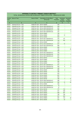
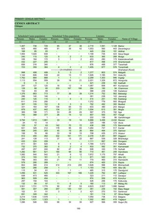
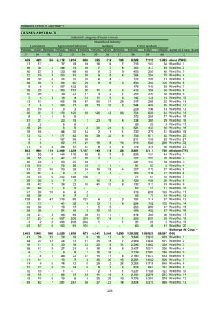
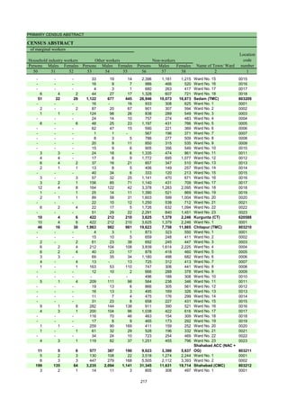
![DISTRICT CENSUS HANDBOOK : GULBARGA
VILLAGE PRIMARY
Persons Males Females Persons Males Females
1 2 3 4 5 6 7 8 9 10
Name of Village
Location
code
number
Total population (including
institutional and houseless
population)
Area of
Village in
hectares
Number of
households
C D Block -
Population in the age-group 0-6
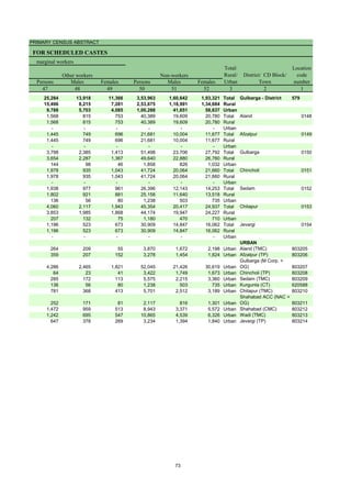
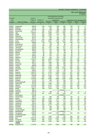
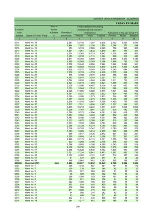
620379 Pochawaram 232.26 237 1,115 545 570 126 62 64
620380 Jilwarsha 732.17 269 1,268 618 650 167 78 89
620381 Chindnoor 1,175.19 178 989 479 510 205 103 102
620382 Lachmasagar 513.60 202 901 467 434 99 58 41
620383 Mambapur 452.39
620384 Hanumannagar 799.58 148 891 454 437 153 79 74
620385 Shadipur 1,790.23 880 4,566 2,366 2,200 676 371 305
620386 Yakatpur 661.43
620387 Nirchalma 1,137.68
620388 Bhoglingdhalli 1,110.98 122 691 350 341 92 45 47
620389 Kalbhavi 764.44 200 1,084 556 528 213 112 101
620390 Chincholi [R] 2,143.09
620391 Neemahosalli 394.36 250 1,525 759 766 207 107 100
620392 Goudanhalli 993.59 203 974 453 521 120 55 65
620393 Daultapur 322.96
620394 Indarpadhosali 291.21 90 504 258 246 75 42 33
620395 Anwar 1,124.67 410 2,037 1,028 1,009 259 131 128
620396 Polakpalli 1,138.58 601 3,112 1,517 1,595 447 214 233
620397 Chikkalingadhalli 1,670.15 304 1,487 715 772 203 106 97
620398 Somlingadhalli 2,236.73 360 1,687 807 880 236 114 122
620399 Ganganpalli 756.04 171 844 429 415 137 76 61
620400 Kallur Road 1,392.83 734 3,594 1,796 1,798 488 259 229
620401 Bhairampalli 627.02 154 794 402 392 127 60 67
620402 Miryan 1,688.35 818 3,981 1,972 2,009 584 291 293
620403 Mukramba 1,223.87 342 1,718 836 882 257 120 137
620404 Hulsgud 842.78 177 964 467 497 143 70 73
620405 Gandhinagar 651.23 150 989 503 486 161 87 74
620406 Rummungud 1,218.12 303 1,609 799 810 227 112 115
620407 Mogha 2,408.69 522 3,057 1,534 1,523 441 231 210
620408 Pastpur 1,477.51 325 1,841 928 913 242 115 127
620409 Rustumpur 1,136.31 274 1,586 780 806 262 134 128
620410 Dhotikol 762.53 263 1,461 679 782 198 98 100
620411 Khudavandpur 493.91 99 556 285 271 88 46 42
620412 Karakmukli 1,829.27 445 2,185 1,072 1,113 279 121 158
620413 Hudadhalli 834.83 181 838 424 414 131 62 69
620414 Chimmaidlai 1,484.36 600 3,071 1,555 1,516 441 242 199
620415 Dastapur 479.05 240 1,444 737 707 245 131 114
620416 Yelakpalli 871.91 230 1,241 640 601 210 112 98
620417 Khairtapur 387.85
620418 Moranhal 293.24 5 23 8 15 4 2 2
620419 Huvinbhavi 754.33 192 1,025 541 484 156 82 74
620420 Ganjgera 441.48 134 711 375 336 153 94 59
620421 Chinkunta 952.42 152 768 388 380 100 61 39
620422 Tadpalli 811.23 77 435 213 222 55 29 26
620423 Allapur 833.37 121 569 299 270 96 57 39
620424 Seri 406.65 95 558 274 284 100 51 49
620425 Jawaharnagar 390.14 142 876 452 424 145 73 72
620426 Sunthan 979.22 229 1,146 569 577 128 64 64
620427 Ratkal 2,914.33 893 4,759 2,346 2,413 666 342 324
620428 Kanchanhal 450.11 94 457 231 226 60 30 30
620429 Kodli 3,019.85 1,197 6,357 3,116 3,241 908 458 450
620430 Nawadgi 661.15 204 1,032 499 533 127 58 69
620431 Wazirgaon 581.90 149 827 416 411 127 62 65
620432 Kudhalli 881.61 237 1,199 527 672 146 68 78
620433 Hosalli 280.12 203 1,060 539 521 122 63 59
620434 Tegaltippi 652.02 230 1,242 636 606 157 81 76
620435 Halcher 1,650.46 396 2,299 1,124 1,175 357 171 186
620436 Korvi 901.14 384 2,428 1,207 1,221 378 194 184
620437 Hodebeeranhalli 1,486.27 473 2,614 1,314 1,300 387 190 197
620438 Sulepeth 2,671.76 1,621 8,016 3,964 4,052 1,138 577 561
-------------Un-inhabited--------------
-------------Un-inhabited--------------
-------------Un-inhabited--------------
-------------Un-inhabited--------------
-------------Un-inhabited--------------
-------------Un-inhabited--------------
138](https://image.slidesharecdn.com/gulbrgahistory-211108111456/85/Gulbrga-history-153-320.jpg)
![PRIMARY CENSUS ABSTRACT
CENSUS ABSTRACT
Chincholi
Persons Males Females Persons Males Females Persons Males Females
11 12 13 14 15 16 17 18 19 2
Name of Village
Literates
Scheduled Castes population Scheduled Tribes population
390 182 208 8 4 4 573 325 248 Pochawaram
617 275 342 1 - 1 527 346 181 Jilwarsha
987 478 509 - - - 320 200 120 Chindnoor
181 99 82 5 3 2 389 253 136 Lachmasagar
Mambapur
890 453 437 - - - 323 219 104 Hanumannagar
3,390 1,765 1,625 32 15 17 2,007 1,295 712 Shadipur
Yakatpur
Nirchalma
658 335 323 - - - 296 197 99 Bhoglingdhalli
1,083 556 527 - - - 373 263 110 Kalbhavi
Chincholi [R]
158 81 77 244 128 116 885 510 375 Neemahosalli
200 98 102 - - - 468 263 205 Goudanhalli
Daultapur
117 58 59 - - - 303 179 124 Indarpadhosali
594 298 296 278 143 135 1,098 678 420 Anwar
1,298 625 673 179 75 104 1,574 910 664 Polakpalli
706 347 359 9 2 7 631 380 251 Chikkalingadhalli
273 126 147 - - - 858 493 365 Somlingadhalli
307 151 156 - - - 442 261 181 Ganganpalli
1,137 560 577 19 10 9 1,856 1,090 766 Kallur Road
518 255 263 - - - 415 247 168 Bhairampalli
1,136 561 575 56 28 28 2,162 1,199 963 Miryan
269 131 138 4 3 1 721 430 291 Mukramba
241 109 132 - - - 405 238 167 Hulsgud
988 503 485 - - - 384 236 148 Gandhinagar
167 92 75 218 111 107 745 452 293 Rummungud
1,283 647 636 62 33 29 1,665 968 697 Mogha
586 298 288 329 159 170 944 578 366 Pastpur
681 327 354 82 42 40 719 428 291 Rustumpur
499 249 250 66 27 39 700 390 310 Dhotikol
155 81 74 - - - 304 181 123 Khudavandpur
525 254 271 6 1 5 1,157 681 476 Karakmukli
210 114 96 4 1 3 534 301 233 Hudadhalli
389 198 191 182 91 91 1,734 1,021 713 Chimmaidlai
487 246 241 114 61 53 672 400 272 Dastapur
478 251 227 14 9 5 671 418 253 Yelakpalli
Khairtapur
- - - - - - 9 2 7 Moranhal
634 332 302 20 11 9 581 371 210 Huvinbhavi
340 183 157 - - - 280 166 114 Ganjgera
226 98 128 - - - 488 277 211 Chinkunta
277 140 137 - - - 261 153 108 Tadpalli
155 85 70 - - - 286 174 112 Allapur
344 164 180 62 28 34 276 161 115 Seri
524 280 244 5 3 2 386 265 121 Jawaharnagar
416 214 202 - - - 569 341 228 Sunthan
1,048 509 539 4 2 2 2,605 1,490 1,115 Ratkal
197 100 97 - - - 240 148 92 Kanchanhal
1,919 947 972 820 428 392 3,598 2,062 1,536 Kodli
137 71 66 25 11 14 658 396 262 Nawadgi
306 149 157 - - - 407 259 148 Wazirgaon
301 145 156 - - - 553 301 252 Kudhalli
356 181 175 - - - 538 334 204 Hosalli
337 169 168 121 66 55 714 411 303 Tegaltippi
477 230 247 19 9 10 1,241 728 513 Halcher
1,378 704 674 270 135 135 1,226 736 490 Korvi
650 337 313 - - - 1,338 773 565 Hodebeeranhalli
1,309 627 682 101 43 58 4,826 2,688 2,138 Sulepeth
-------------Un-inhabited--------------
-------------Un-inhabited--------------
-------------Un-inhabited--------------
-------------Un-inhabited--------------
-------------Un-inhabited--------------
-------------Un-inhabited--------------
139](https://image.slidesharecdn.com/gulbrgahistory-211108111456/85/Gulbrga-history-154-320.jpg)
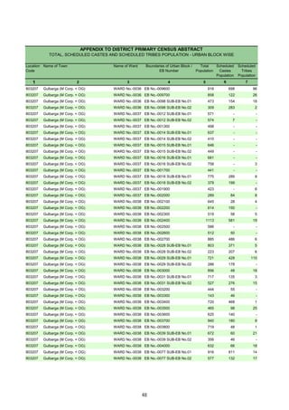
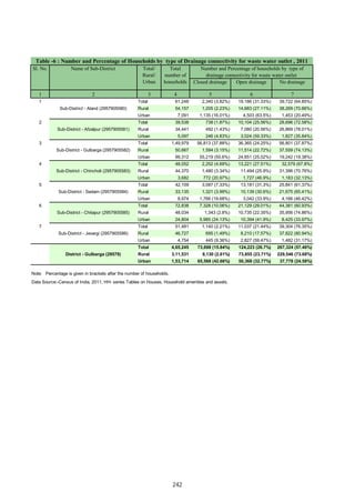
![DISTRICT CENSUS HANDBOOK : GULBARGA
VILLAGE PRIMARY
C D Block -
Persons Males Females Persons Males Females Persons Males Females
1 2 20 21 22 23 24 25 26 27 28
Name of Village
Location
code
number
Illiterates Total workers Main workers
620379 Pochawaram 542 220 322 678 348 330 589 309 280
620380 Jilwarsha 741 272 469 800 417 383 772 408 364
620381 Chindnoor 669 279 390 523 251 272 394 205 189
620382 Lachmasagar 512 214 298 592 297 295 558 273 285
620383 Mambapur
620384 Hanumannagar 568 235 333 495 238 257 331 166 165
620385 Shadipur 2,559 1,071 1,488 2,381 1,241 1,140 1,976 1,143 833
620386 Yakatpur
620387 Nirchalma
620388 Bhoglingdhalli 395 153 242 288 180 108 271 167 104
620389 Kalbhavi 711 293 418 607 304 303 593 293 300
620390 Chincholi [R]
620391 Neemahosalli 640 249 391 604 373 231 520 364 156
620392 Goudanhalli 506 190 316 489 269 220 330 244 86
620393 Daultapur
620394 Indarpadhosali 201 79 122 232 151 81 126 107 19
620395 Anwar 939 350 589 1,385 706 679 736 452 284
620396 Polakpalli 1,538 607 931 1,393 864 529 960 630 330
620397 Chikkalingadhalli 856 335 521 893 433 460 643 375 268
620398 Somlingadhalli 829 314 515 1,028 501 527 946 474 472
620399 Ganganpalli 402 168 234 524 270 254 499 259 240
620400 Kallur Road 1,738 706 1,032 1,891 1,034 857 1,057 609 448
620401 Bhairampalli 379 155 224 358 218 140 337 214 123
620402 Miryan 1,819 773 1,046 1,748 1,132 616 1,650 1,117 533
620403 Mukramba 997 406 591 840 459 381 615 402 213
620404 Hulsgud 559 229 330 400 244 156 144 123 21
620405 Gandhinagar 605 267 338 365 229 136 345 213 132
620406 Rummungud 864 347 517 450 421 29 429 404 25
620407 Mogha 1,392 566 826 1,328 794 534 776 620 156
620408 Pastpur 897 350 547 898 512 386 882 504 378
620409 Rustumpur 867 352 515 789 418 371 250 207 43
620410 Dhotikol 761 289 472 815 367 448 508 270 238
620411 Khudavandpur 252 104 148 268 139 129 159 118 41
620412 Karakmukli 1,028 391 637 1,303 637 666 742 501 241
620413 Hudadhalli 304 123 181 387 219 168 386 219 167
620414 Chimmaidlai 1,337 534 803 1,526 874 652 1,505 863 642
620415 Dastapur 772 337 435 564 365 199 528 334 194
620416 Yelakpalli 570 222 348 524 329 195 517 324 193
620417 Khairtapur
620418 Moranhal 14 6 8 7 4 3 7 4 3
620419 Huvinbhavi 444 170 274 542 287 255 540 285 255
620420 Ganjgera 431 209 222 351 185 166 334 181 153
620421 Chinkunta 280 111 169 409 215 194 265 169 96
620422 Tadpalli 174 60 114 195 102 93 195 102 93
620423 Allapur 283 125 158 272 163 109 261 159 102
620424 Seri 282 113 169 231 145 86 173 126 47
620425 Jawaharnagar 490 187 303 436 235 201 432 233 199
620426 Sunthan 577 228 349 596 301 295 566 284 282
620427 Ratkal 2,154 856 1,298 2,076 1,279 797 1,660 1,019 641
620428 Kanchanhal 217 83 134 185 98 87 183 97 86
620429 Kodli 2,759 1,054 1,705 2,871 1,632 1,239 1,813 1,230 583
620430 Nawadgi 374 103 271 408 259 149 406 257 149
620431 Wazirgaon 420 157 263 445 235 210 442 233 209
620432 Kudhalli 646 226 420 611 295 316 566 285 281
620433 Hosalli 522 205 317 445 316 129 421 303 118
620434 Tegaltippi 528 225 303 559 332 227 543 327 216
620435 Halcher 1,058 396 662 784 582 202 712 563 149
620436 Korvi 1,202 471 731 1,277 648 629 445 415 30
620437 Hodebeeranhalli 1,276 541 735 1,372 785 587 335 237 98
620438 Sulepeth 3,190 1,276 1,914 3,035 2,024 1,011 2,729 1,871 858
-------------Un-inhabited--------------
-------------Un-inhabited--------------
-------------Un-inhabited--------------
-------------Un-inhabited--------------
-------------Un-inhabited--------------
-------------Un-inhabited--------------
140](https://image.slidesharecdn.com/gulbrgahistory-211108111456/85/Gulbrga-history-155-320.jpg)
![PRIMARY CENSUS ABSTRACT
CENSUS ABSTRACT
Chincholi
Persons Males Females Persons Males Females Persons Males Females Persons Males Females
29 30 31 32 33 34 35 36 37 38 39 40 2
Cultivators
Name of Village
Household industry
workers
Agricultural labourers
Industrial category of main workers
Other workers
124 73 51 431 213 218 2 1 1 32 22 10 Pochawaram
462 231 231 268 154 114 - - - 42 23 19 Jilwarsha
65 62 3 279 113 166 5 2 3 45 28 17 Chindnoor
224 219 5 300 23 277 9 7 2 25 24 1 Lachmasagar
Mambapur
16 11 5 308 152 156 - - - 7 3 4 Hanumannagar
572 403 169 1,151 548 603 9 6 3 244 186 58 Shadipur
Yakatpur
Nirchalma
62 49 13 163 81 82 2 1 1 44 36 8 Bhoglingdhalli
318 152 166 254 129 125 7 5 2 14 7 7 Kalbhavi
Chincholi [R]
105 102 3 195 75 120 8 7 1 212 180 32 Neemahosalli
122 110 12 122 61 61 2 1 1 84 72 12 Goudanhalli
Daultapur
65 62 3 36 22 14 - - - 25 23 2 Indarpadhosali
232 149 83 306 139 167 12 4 8 186 160 26 Anwar
103 89 14 242 140 102 4 3 1 611 398 213 Polakpalli
279 163 116 284 149 135 6 5 1 74 58 16 Chikkalingadhalli
337 175 162 326 105 221 2 1 1 281 193 88 Somlingadhalli
50 50 - 232 69 163 4 2 2 213 138 75 Ganganpalli
127 108 19 412 169 243 52 29 23 466 303 163 Kallur Road
94 73 21 49 2 47 4 4 - 190 135 55 Bhairampalli
323 277 46 240 76 164 7 3 4 1,080 761 319 Miryan
229 158 71 273 146 127 5 4 1 108 94 14 Mukramba
75 72 3 7 7 - 4 4 - 58 40 18 Hulsgud
134 128 6 144 35 109 - - - 67 50 17 Gandhinagar
216 215 1 137 123 14 - - - 76 66 10 Rummungud
317 300 17 294 182 112 30 27 3 135 111 24 Mogha
296 207 89 387 134 253 5 2 3 194 161 33 Pastpur
147 136 11 42 21 21 11 10 1 50 40 10 Rustumpur
363 203 160 85 38 47 12 9 3 48 20 28 Dhotikol
79 78 1 45 13 32 4 1 3 31 26 5 Khudavandpur
605 405 200 11 5 6 1 1 - 125 90 35 Karakmukli
118 116 2 224 69 155 10 5 5 34 29 5 Hudadhalli
135 112 23 1,131 558 573 29 19 10 210 174 36 Chimmaidlai
88 86 2 290 122 168 5 5 - 145 121 24 Dastapur
114 110 4 342 165 177 - - - 61 49 12 Yelakpalli
Khairtapur
- - - 7 4 3 - - - - - - Moranhal
68 66 2 439 197 242 - - - 33 22 11 Huvinbhavi
64 61 3 247 102 145 - - - 23 18 5 Ganjgera
50 47 3 136 68 68 7 6 1 72 48 24 Chinkunta
32 32 - 136 49 87 - - - 27 21 6 Tadpalli
67 45 22 132 70 62 1 1 - 61 43 18 Allapur
48 43 5 78 50 28 3 2 1 44 31 13 Seri
75 44 31 201 96 105 7 4 3 149 89 60 Jawaharnagar
95 80 15 434 178 256 1 1 - 36 25 11 Sunthan
213 189 24 944 494 450 54 38 16 449 298 151 Ratkal
68 58 10 100 25 75 - - - 15 14 1 Kanchanhal
306 242 64 864 471 393 36 27 9 607 490 117 Kodli
90 78 12 250 120 130 1 1 - 65 58 7 Nawadgi
49 33 16 339 155 184 16 9 7 38 36 2 Wazirgaon
99 75 24 410 168 242 3 2 1 54 40 14 Kudhalli
179 152 27 188 105 83 2 2 - 52 44 8 Hosalli
110 109 1 352 140 212 1 1 - 80 77 3 Tegaltippi
309 292 17 276 165 111 - - - 127 106 21 Halcher
126 124 2 199 188 11 - - - 120 103 17 Korvi
121 110 11 171 94 77 2 2 - 41 31 10 Hodebeeranhalli
357 301 56 1,015 522 493 142 85 57 1,215 963 252 Sulepeth
-------------Un-inhabited--------------
-------------Un-inhabited--------------
-------------Un-inhabited--------------
-------------Un-inhabited--------------
-------------Un-inhabited--------------
-------------Un-inhabited--------------
141](https://image.slidesharecdn.com/gulbrgahistory-211108111456/85/Gulbrga-history-156-320.jpg)
![DISTRICT CENSUS HANDBOOK : GULBARGA
VILLAGE PRIMARY
C D Block -
Persons Males Females Persons Males Females Persons Males Females
1 2 41 42 43 44 45 46 47 48 49
Name of Village
Marginal workers Cultivators Agricultural labourers
Industrial category
Location
code
number
620379 Pochawaram 89 39 50 16 7 9 68 29 39
620380 Jilwarsha 28 9 19 11 2 9 12 3 9
620381 Chindnoor 129 46 83 2 2 - 98 29 69
620382 Lachmasagar 34 24 10 13 12 1 9 2 7
620383 Mambapur
620384 Hanumannagar 164 72 92 - - - 38 16 22
620385 Shadipur 405 98 307 47 20 27 251 31 220
620386 Yakatpur
620387 Nirchalma
620388 Bhoglingdhalli 17 13 4 4 3 1 12 9 3
620389 Kalbhavi 14 11 3 1 1 - 6 4 2
620390 Chincholi [R]
620391 Neemahosalli 84 9 75 5 1 4 69 4 65
620392 Goudanhalli 159 25 134 7 2 5 123 8 115
620393 Daultapur
620394 Indarpadhosali 106 44 62 - - - 83 28 55
620395 Anwar 649 254 395 30 15 15 377 107 270
620396 Polakpalli 433 234 199 13 7 6 218 104 114
620397 Chikkalingadhalli 250 58 192 50 - 50 152 38 114
620398 Somlingadhalli 82 27 55 16 7 9 35 3 32
620399 Ganganpalli 25 11 14 - - - 6 2 4
620400 Kallur Road 834 425 409 51 30 21 233 71 162
620401 Bhairampalli 21 4 17 2 1 1 15 2 13
620402 Miryan 98 15 83 6 3 3 55 1 54
620403 Mukramba 225 57 168 3 2 1 201 40 161
620404 Hulsgud 256 121 135 - - - 183 81 102
620405 Gandhinagar 20 16 4 1 1 - 3 - 3
620406 Rummungud 21 17 4 - - - 8 6 2
620407 Mogha 552 174 378 66 18 48 391 95 296
620408 Pastpur 16 8 8 - - - 6 1 5
620409 Rustumpur 539 211 328 45 9 36 404 149 255
620410 Dhotikol 307 97 210 50 26 24 79 27 52
620411 Khudavandpur 109 21 88 1 1 - 105 19 86
620412 Karakmukli 561 136 425 9 5 4 527 114 413
620413 Hudadhalli 1 - 1 - - - 1 - 1
620414 Chimmaidlai 21 11 10 3 1 2 8 3 5
620415 Dastapur 36 31 5 - - - 4 3 1
620416 Yelakpalli 7 5 2 1 1 - 3 1 2
620417 Khairtapur
620418 Moranhal - - - - - - - - -
620419 Huvinbhavi 2 2 - - - - 2 2 -
620420 Ganjgera 17 4 13 2 - 2 13 3 10
620421 Chinkunta 144 46 98 5 2 3 82 27 55
620422 Tadpalli - - - - - - - - -
620423 Allapur 11 4 7 2 2 - 5 2 3
620424 Seri 58 19 39 9 1 8 24 9 15
620425 Jawaharnagar 4 2 2 2 - 2 1 1 -
620426 Sunthan 30 17 13 - - - 18 9 9
620427 Ratkal 416 260 156 35 22 13 195 116 79
620428 Kanchanhal 2 1 1 - - - 1 1 -
620429 Kodli 1,058 402 656 51 24 27 727 244 483
620430 Nawadgi 2 2 - - - - 2 2 -
620431 Wazirgaon 3 2 1 - - - 2 1 1
620432 Kudhalli 45 10 35 11 3 8 23 4 19
620433 Hosalli 24 13 11 - - - 17 7 10
620434 Tegaltippi 16 5 11 1 1 - 10 - 10
620435 Halcher 72 19 53 3 1 2 68 17 51
620436 Korvi 832 233 599 2 1 1 643 103 540
620437 Hodebeeranhalli 1,037 548 489 2 2 - 1,000 524 476
620438 Sulepeth 306 153 153 28 12 16 161 59 102
-------------Un-inhabited--------------
-------------Un-inhabited--------------
-------------Un-inhabited--------------
-------------Un-inhabited--------------
-------------Un-inhabited--------------
-------------Un-inhabited--------------
142](https://image.slidesharecdn.com/gulbrgahistory-211108111456/85/Gulbrga-history-157-320.jpg)
![PRIMARY CENSUS ABSTRACT
CENSUS ABSTRACT
Chincholi
Persons Males Females Persons Males Females Persons Males Females
50 51 52 53 54 55 56 57 58 2 1
Location
code
number
Household industry workers
Name of Village
Other workers Non-workers
of marginal workers
5 3 2 - - - 437 197 240 Pochawaram 620379
- - - 5 4 1 468 201 267 Jilwarsha 620380
3 1 2 26 14 12 466 228 238 Chindnoor 620381
6 5 1 6 5 1 309 170 139 Lachmasagar 620382
Mambapur 620383
16 5 11 110 51 59 396 216 180 Hanumannagar 620384
8 1 7 99 46 53 2,185 1,125 1,060 Shadipur 620385
Yakatpur 620386
Nirchalma 620387
- - - 1 1 - 403 170 233 Bhoglingdhalli 620388
- - - 7 6 1 477 252 225 Kalbhavi 620389
Chincholi [R] 620390
4 1 3 6 3 3 921 386 535 Neemahosalli 620391
2 1 1 27 14 13 485 184 301 Goudanhalli 620392
Daultapur 620393
- - - 23 16 7 272 107 165 Indarpadhosali 620394
171 82 89 71 50 21 652 322 330 Anwar 620395
3 - 3 199 123 76 1,719 653 1,066 Polakpalli 620396
2 1 1 46 19 27 594 282 312 Chikkalingadhalli 620397
3 - 3 28 17 11 659 306 353 Somlingadhalli 620398
1 - 1 18 9 9 320 159 161 Ganganpalli 620399
28 12 16 522 312 210 1,703 762 941 Kallur Road 620400
- - - 4 1 3 436 184 252 Bhairampalli 620401
1 - 1 36 11 25 2,233 840 1,393 Miryan 620402
1 - 1 20 15 5 878 377 501 Mukramba 620403
3 1 2 70 39 31 564 223 341 Hulsgud 620404
- - - 16 15 1 624 274 350 Gandhinagar 620405
- - - 13 11 2 1,159 378 781 Rummungud 620406
11 5 6 84 56 28 1,729 740 989 Mogha 620407
2 1 1 8 6 2 943 416 527 Pastpur 620408
18 7 11 72 46 26 797 362 435 Rustumpur 620409
11 4 7 167 40 127 646 312 334 Dhotikol 620410
- - - 3 1 2 288 146 142 Khudavandpur 620411
1 1 - 24 16 8 882 435 447 Karakmukli 620412
- - - - - - 451 205 246 Hudadhalli 620413
- - - 10 7 3 1,545 681 864 Chimmaidlai 620414
- - - 32 28 4 880 372 508 Dastapur 620415
- - - 3 3 - 717 311 406 Yelakpalli 620416
Khairtapur 620417
- - - - - - 16 4 12 Moranhal 620418
- - - - - - 483 254 229 Huvinbhavi 620419
- - - 2 1 1 360 190 170 Ganjgera 620420
16 4 12 41 13 28 359 173 186 Chinkunta 620421
- - - - - - 240 111 129 Tadpalli 620422
1 - 1 3 - 3 297 136 161 Allapur 620423
1 1 - 24 8 16 327 129 198 Seri 620424
- - - 1 1 - 440 217 223 Jawaharnagar 620425
- - - 12 8 4 550 268 282 Sunthan 620426
34 25 9 152 97 55 2,683 1,067 1,616 Ratkal 620427
- - - 1 - 1 272 133 139 Kanchanhal 620428
45 11 34 235 123 112 3,486 1,484 2,002 Kodli 620429
- - - - - - 624 240 384 Nawadgi 620430
1 1 - - - - 382 181 201 Wazirgaon 620431
2 - 2 9 3 6 588 232 356 Kudhalli 620432
1 1 - 6 5 1 615 223 392 Hosalli 620433
- - - 5 4 1 683 304 379 Tegaltippi 620434
- - - 1 1 - 1,515 542 973 Halcher 620435
3 2 1 184 127 57 1,151 559 592 Korvi 620436
14 7 7 21 15 6 1,242 529 713 Hodebeeranhalli 620437
19 7 12 98 75 23 4,981 1,940 3,041 Sulepeth 620438
-------------Un-inhabited--------------
-------------Un-inhabited--------------
-------------Un-inhabited--------------
-------------Un-inhabited--------------
-------------Un-inhabited--------------
-------------Un-inhabited--------------
143](https://image.slidesharecdn.com/gulbrgahistory-211108111456/85/Gulbrga-history-158-320.jpg)
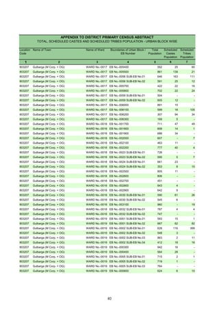
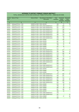
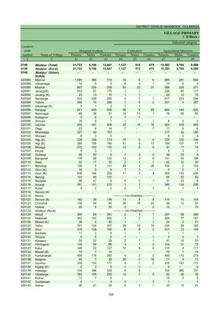
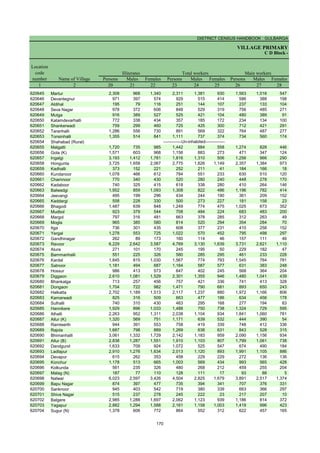
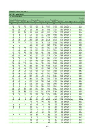
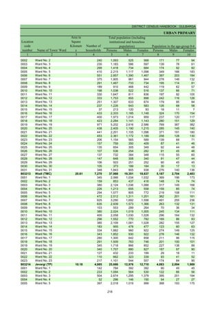
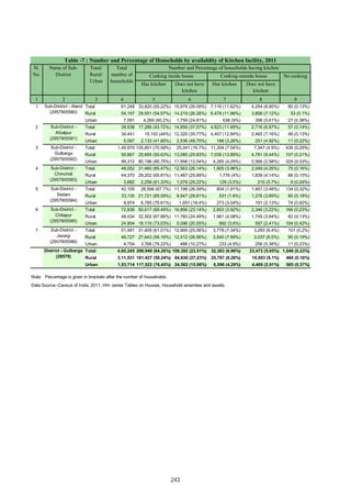
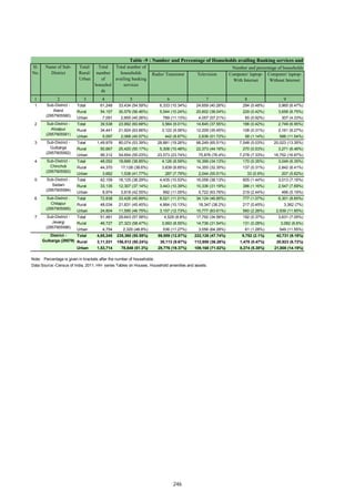
![DISTRICT CENSUS HANDBOOK : GULBARGA
VILLAGE PRIMARY
Persons Males Females Persons Males Females
1 2 3 4 5 6 7 8 9 10
Name of Village
Location
code
number
Total population (including
institutional and houseless
population)
Area of
Village in
hectares
Number of
households
C D Block -
Population in the age-group 0-6
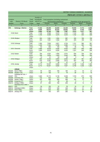
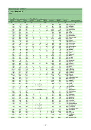
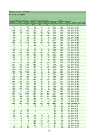
620439 Pardarmotakpalli 595.35 172 811 400 411 114 51 63
620440 Bhaktampalli 369.61 205 1,086 524 562 163 69 94
620441 Sangam[K] 384.34
620442 Garagpalli 836.11 279 1,390 702 688 168 87 81
620443 Ramteerth 519.38 146 663 327 336 97 53 44
620444 Bedagpalli 880.38 194 1,027 535 492 152 85 67
620445 Yakapur 533.69 133 737 368 369 94 48 46
620446 Penchganpalli 633.71 180 954 477 477 165 93 72
620447 Kupnoor 1,180.43 316 1,694 851 843 240 116 124
620448 Gadikeshwar 2,722.28 606 3,412 1,690 1,722 461 245 216
620449 Benkanhalli 472.79 136 791 396 395 87 42 45
620450 Bhantanahalli 626.53 219 1,261 646 615 202 106 96
620451 Keroli 1,441.05 359 1,875 923 952 268 146 122
620452 Kordampalli 1,043.34 317 1,687 833 854 241 116 125
620453 Iragpalli 750.62 246 1,297 640 657 203 94 109
620454 Ghanpur 643.21 303 1,352 678 674 194 112 82
620455 Burugpalli 456.48 173 869 437 432 119 57 62
620456 Chatarsal 774.30 201 1,007 513 494 137 65 72
620457 Karachkhed 1,283.92 393 1,871 911 960 286 149 137
620458 Nidugunda 2,666.14 1,126 5,682 2,822 2,860 683 364 319
620459 Venkatapur 744.99 144 764 371 393 129 57 72
620460 Chintpalli 1,049.97 258 1,421 714 707 200 94 106
620461 Raikod 934.85 250 1,377 704 673 199 105 94
620462 Bhootpur 860.93 213 1,145 545 600 146 69 77
620463 Kallur [K] 152.25
620464 Kallur[B] 352.31
620465 Rudnoor 954.68 298 1,516 737 779 210 105 105
620466 Hovinhalli 606.95 176 899 456 443 145 83 62
620467 Siroli 1,271.90 386 2,092 1,022 1,070 307 168 139
620468 Halkoda 746.47 172 899 446 453 94 41 53
620469 Potangal 1,009.27 220 1,104 529 575 154 74 80
620470 Jettur 1,050.82 309 1,609 786 823 188 84 104
-------------Un-inhabited--------------
-------------Un-inhabited--------------
-------------Un-inhabited--------------
144](https://image.slidesharecdn.com/gulbrgahistory-211108111456/85/Gulbrga-history-159-320.jpg)
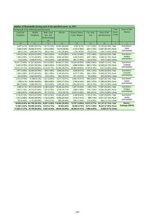
![PRIMARY CENSUS ABSTRACT
CENSUS ABSTRACT
Chincholi
Persons Males Females Persons Males Females Persons Males Females
11 12 13 14 15 16 17 18 19 2
Name of Village
Literates
Scheduled Castes population Scheduled Tribes population
151 78 73 294 150 144 402 244 158 Pardarmotakpalli
408 190 218 - - - 525 309 216 Bhaktampalli
Sangam[K]
138 72 66 - - - 825 491 334 Garagpalli
270 130 140 19 11 8 403 233 170 Ramteerth
353 185 168 - - - 536 343 193 Bedagpalli
205 107 98 126 68 58 409 251 158 Yakapur
257 128 129 532 267 265 446 260 186 Penchganpalli
235 116 119 230 119 111 1,044 605 439 Kupnoor
593 295 298 419 199 220 1,828 1,020 808 Gadikeshwar
142 70 72 - - - 493 287 206 Benkanhalli
303 147 156 141 80 61 676 403 273 Bhantanahalli
412 207 205 19 9 10 1,066 601 465 Keroli
505 242 263 5 3 2 875 513 362 Kordampalli
295 143 152 - - - 610 369 241 Iragpalli
166 88 78 134 73 61 749 461 288 Ghanpur
307 156 151 15 7 8 447 259 188 Burugpalli
97 47 50 84 40 44 458 300 158 Chatarsal
653 311 342 8 3 5 825 467 358 Karachkhed
973 491 482 150 77 73 2,936 1,696 1,240 Nidugunda
238 120 118 - - - 282 165 117 Venkatapur
214 118 96 - - - 730 445 285 Chintpalli
315 161 154 137 80 57 696 424 272 Raikod
211 100 111 19 8 11 610 340 270 Bhootpur
Kallur [K]
Kallur[B]
249 109 140 15 10 5 736 432 304 Rudnoor
286 142 144 - - - 346 193 153 Hovinhalli
743 373 370 - - - 1,013 581 432 Siroli
289 144 145 - - - 405 246 159 Halkoda
166 75 91 13 4 9 419 245 174 Potangal
339 158 181 - - - 834 485 349 Jettur
-------------Un-inhabited--------------
-------------Un-inhabited--------------
-------------Un-inhabited--------------
145](https://image.slidesharecdn.com/gulbrgahistory-211108111456/85/Gulbrga-history-160-320.jpg)
![DISTRICT CENSUS HANDBOOK : GULBARGA
VILLAGE PRIMARY
C D Block -
Persons Males Females Persons Males Females Persons Males Females
1 2 20 21 22 23 24 25 26 27 28
Name of Village
Location
code
number
Illiterates Total workers Main workers
620439 Pardarmotakpalli 409 156 253 415 230 185 414 229 185
620440 Bhaktampalli 561 215 346 472 270 202 442 256 186
620441 Sangam[K]
620442 Garagpalli 565 211 354 736 363 373 596 318 278
620443 Ramteerth 260 94 166 339 185 154 336 183 153
620444 Bedagpalli 491 192 299 553 291 262 507 277 230
620445 Yakapur 328 117 211 184 173 11 125 120 5
620446 Penchganpalli 508 217 291 483 259 224 469 255 214
620447 Kupnoor 650 246 404 797 464 333 561 400 161
620448 Gadikeshwar 1,584 670 914 1,576 882 694 419 299 120
620449 Benkanhalli 298 109 189 349 227 122 334 219 115
620450 Bhantanahalli 585 243 342 502 349 153 493 344 149
620451 Keroli 809 322 487 602 456 146 534 398 136
620452 Kordampalli 812 320 492 744 472 272 728 463 265
620453 Iragpalli 687 271 416 678 363 315 674 361 313
620454 Ghanpur 603 217 386 558 335 223 408 275 133
620455 Burugpalli 422 178 244 497 277 220 497 277 220
620456 Chatarsal 549 213 336 536 311 225 507 303 204
620457 Karachkhed 1,046 444 602 1,066 524 542 1,047 519 528
620458 Nidugunda 2,746 1,126 1,620 2,403 1,519 884 2,359 1,498 861
620459 Venkatapur 482 206 276 466 245 221 299 184 115
620460 Chintpalli 691 269 422 610 338 272 537 315 222
620461 Raikod 681 280 401 673 394 279 612 378 234
620462 Bhootpur 535 205 330 484 281 203 290 203 87
620463 Kallur [K]
620464 Kallur[B]
620465 Rudnoor 780 305 475 771 408 363 484 278 206
620466 Hovinhalli 553 263 290 436 251 185 430 246 184
620467 Siroli 1,079 441 638 942 586 356 940 585 355
620468 Halkoda 494 200 294 530 286 244 488 278 210
620469 Potangal 685 284 401 649 321 328 588 297 291
620470 Jettur 775 301 474 877 490 387 792 476 316
-------------Un-inhabited--------------
-------------Un-inhabited--------------
-------------Un-inhabited--------------
146](https://image.slidesharecdn.com/gulbrgahistory-211108111456/85/Gulbrga-history-161-320.jpg)
![PRIMARY CENSUS ABSTRACT
CENSUS ABSTRACT
Chincholi
Persons Males Females Persons Males Females Persons Males Females Persons Males Females
29 30 31 32 33 34 35 36 37 38 39 40 2
Cultivators
Name of Village
Household industry
workers
Agricultural labourers
Industrial category of main workers
Other workers
118 116 2 220 54 166 4 2 2 72 57 15 Pardarmotakpalli
108 67 41 303 165 138 1 1 - 30 23 7 Bhaktampalli
Sangam[K]
203 111 92 337 162 175 5 5 - 51 40 11 Garagpalli
118 70 48 195 94 101 - - - 23 19 4 Ramteerth
170 92 78 253 123 130 7 4 3 77 58 19 Bedagpalli
116 116 - - - - - - - 9 4 5 Yakapur
89 82 7 290 97 193 - - - 90 76 14 Penchganpalli
211 178 33 204 100 104 - - - 146 122 24 Kupnoor
185 151 34 116 59 57 2 2 - 116 87 29 Gadikeshwar
106 103 3 167 70 97 - - - 61 46 15 Benkanhalli
188 181 7 246 116 130 4 3 1 55 44 11 Bhantanahalli
307 245 62 162 98 64 6 5 1 59 50 9 Keroli
220 171 49 461 254 207 1 1 - 46 37 9 Kordampalli
270 181 89 378 163 215 - - - 26 17 9 Iragpalli
98 86 12 207 103 104 8 8 - 95 78 17 Ghanpur
151 87 64 310 160 150 - - - 36 30 6 Burugpalli
44 34 10 366 191 175 - - - 97 78 19 Chatarsal
166 108 58 626 256 370 12 4 8 243 151 92 Karachkhed
322 288 34 1,256 607 649 72 41 31 709 562 147 Nidugunda
122 105 17 130 44 86 - - - 47 35 12 Venkatapur
100 89 11 415 208 207 5 5 - 17 13 4 Chintpalli
168 141 27 415 214 201 1 - 1 28 23 5 Raikod
148 116 32 95 54 41 1 1 - 46 32 14 Bhootpur
Kallur [K]
Kallur[B]
197 133 64 252 116 136 - - - 35 29 6 Rudnoor
64 58 6 96 30 66 - - - 270 158 112 Hovinhalli
247 186 61 470 232 238 1 - 1 222 167 55 Siroli
133 111 22 303 128 175 3 2 1 49 37 12 Halkoda
234 124 110 300 133 167 9 5 4 45 35 10 Potangal
193 148 45 519 273 246 - - - 80 55 25 Jettur
-------------Un-inhabited--------------
-------------Un-inhabited--------------
-------------Un-inhabited--------------
147](https://image.slidesharecdn.com/gulbrgahistory-211108111456/85/Gulbrga-history-162-320.jpg)
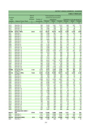
![DISTRICT CENSUS HANDBOOK : GULBARGA
VILLAGE PRIMARY
C D Block -
Persons Males Females Persons Males Females Persons Males Females
1 2 41 42 43 44 45 46 47 48 49
Name of Village
Marginal workers Cultivators Agricultural labourers
Industrial category
Location
code
number
620439 Pardarmotakpalli 1 1 - - - - - - -
620440 Bhaktampalli 30 14 16 9 2 7 7 2 5
620441 Sangam[K]
620442 Garagpalli 140 45 95 6 - 6 118 36 82
620443 Ramteerth 3 2 1 - - - 2 1 1
620444 Bedagpalli 46 14 32 13 5 8 26 4 22
620445 Yakapur 59 53 6 - - - 51 47 4
620446 Penchganpalli 14 4 10 3 2 1 9 - 9
620447 Kupnoor 236 64 172 9 3 6 218 55 163
620448 Gadikeshwar 1,157 583 574 13 4 9 968 466 502
620449 Benkanhalli 15 8 7 - - - 3 1 2
620450 Bhantanahalli 9 5 4 1 - 1 7 4 3
620451 Keroli 68 58 10 3 3 - 17 12 5
620452 Kordampalli 16 9 7 - - - - - -
620453 Iragpalli 4 2 2 - - - 1 - 1
620454 Ghanpur 150 60 90 13 6 7 123 44 79
620455 Burugpalli - - - - - - - - -
620456 Chatarsal 29 8 21 - - - 23 3 20
620457 Karachkhed 19 5 14 - - - 14 4 10
620458 Nidugunda 44 21 23 4 3 1 21 4 17
620459 Venkatapur 167 61 106 1 - 1 157 58 99
620460 Chintpalli 73 23 50 10 2 8 41 8 33
620461 Raikod 61 16 45 1 1 - 58 14 44
620462 Bhootpur 194 78 116 9 4 5 125 50 75
620463 Kallur [K]
620464 Kallur[B]
620465 Rudnoor 287 130 157 4 2 2 271 119 152
620466 Hovinhalli 6 5 1 1 1 - - - -
620467 Siroli 2 1 1 - - - 1 - 1
620468 Halkoda 42 8 34 3 - 3 35 7 28
620469 Potangal 61 24 37 1 - 1 44 14 30
620470 Jettur 85 14 71 14 7 7 67 6 61
-------------Un-inhabited--------------
-------------Un-inhabited--------------
-------------Un-inhabited--------------
148](https://image.slidesharecdn.com/gulbrgahistory-211108111456/85/Gulbrga-history-163-320.jpg)
![PRIMARY CENSUS ABSTRACT
CENSUS ABSTRACT
Chincholi
Persons Males Females Persons Males Females Persons Males Females
50 51 52 53 54 55 56 57 58 2 1
Location
code
number
Household industry workers
Name of Village
Other workers Non-workers
of marginal workers
- - - 1 1 - 396 170 226 Pardarmotakpalli 620439
3 2 1 11 8 3 614 254 360 Bhaktampalli 620440
Sangam[K] 620441
1 - 1 15 9 6 654 339 315 Garagpalli 620442
- - - 1 1 - 324 142 182 Ramteerth 620443
- - - 7 5 2 474 244 230 Bedagpalli 620444
- - - 8 6 2 553 195 358 Yakapur 620445
- - - 2 2 - 471 218 253 Penchganpalli 620446
5 3 2 4 3 1 897 387 510 Kupnoor 620447
38 15 23 138 98 40 1,836 808 1,028 Gadikeshwar 620448
- - - 12 7 5 442 169 273 Benkanhalli 620449
- - - 1 1 - 759 297 462 Bhantanahalli 620450
14 11 3 34 32 2 1,273 467 806 Keroli 620451
9 4 5 7 5 2 943 361 582 Kordampalli 620452
- - - 3 2 1 619 277 342 Iragpalli 620453
4 2 2 10 8 2 794 343 451 Ghanpur 620454
- - - - - - 372 160 212 Burugpalli 620455
- - - 6 5 1 471 202 269 Chatarsal 620456
- - - 5 1 4 805 387 418 Karachkhed 620457
1 1 - 18 13 5 3,279 1,303 1,976 Nidugunda 620458
- - - 9 3 6 298 126 172 Venkatapur 620459
4 2 2 18 11 7 811 376 435 Chintpalli 620460
- - - 2 1 1 704 310 394 Raikod 620461
- - - 60 24 36 661 264 397 Bhootpur 620462
Kallur [K] 620463
Kallur[B] 620464
- - - 12 9 3 745 329 416 Rudnoor 620465
- - - 5 4 1 463 205 258 Hovinhalli 620466
- - - 1 1 - 1,150 436 714 Siroli 620467
- - - 4 1 3 369 160 209 Halkoda 620468
8 5 3 8 5 3 455 208 247 Potangal 620469
1 - 1 3 1 2 732 296 436 Jettur 620470
-------------Un-inhabited--------------
-------------Un-inhabited--------------
-------------Un-inhabited--------------
149](https://image.slidesharecdn.com/gulbrgahistory-211108111456/85/Gulbrga-history-164-320.jpg)


Sri M. S. Suresh, S. I. Gr. II Sri M. S. Suresh, S. I. Gr. II Sri M. S. Suresh, S. I. Gr. II Sri M. S. Suresh, S. I. Gr. II Sri M. S. Suresh, S. I. Gr. II Sri M. S. Suresh, S. I. Gr. II Sri M. S. Suresh, S. I. Gr. II Sri M. S. Suresh, S. I. Gr. II Sri M. S


