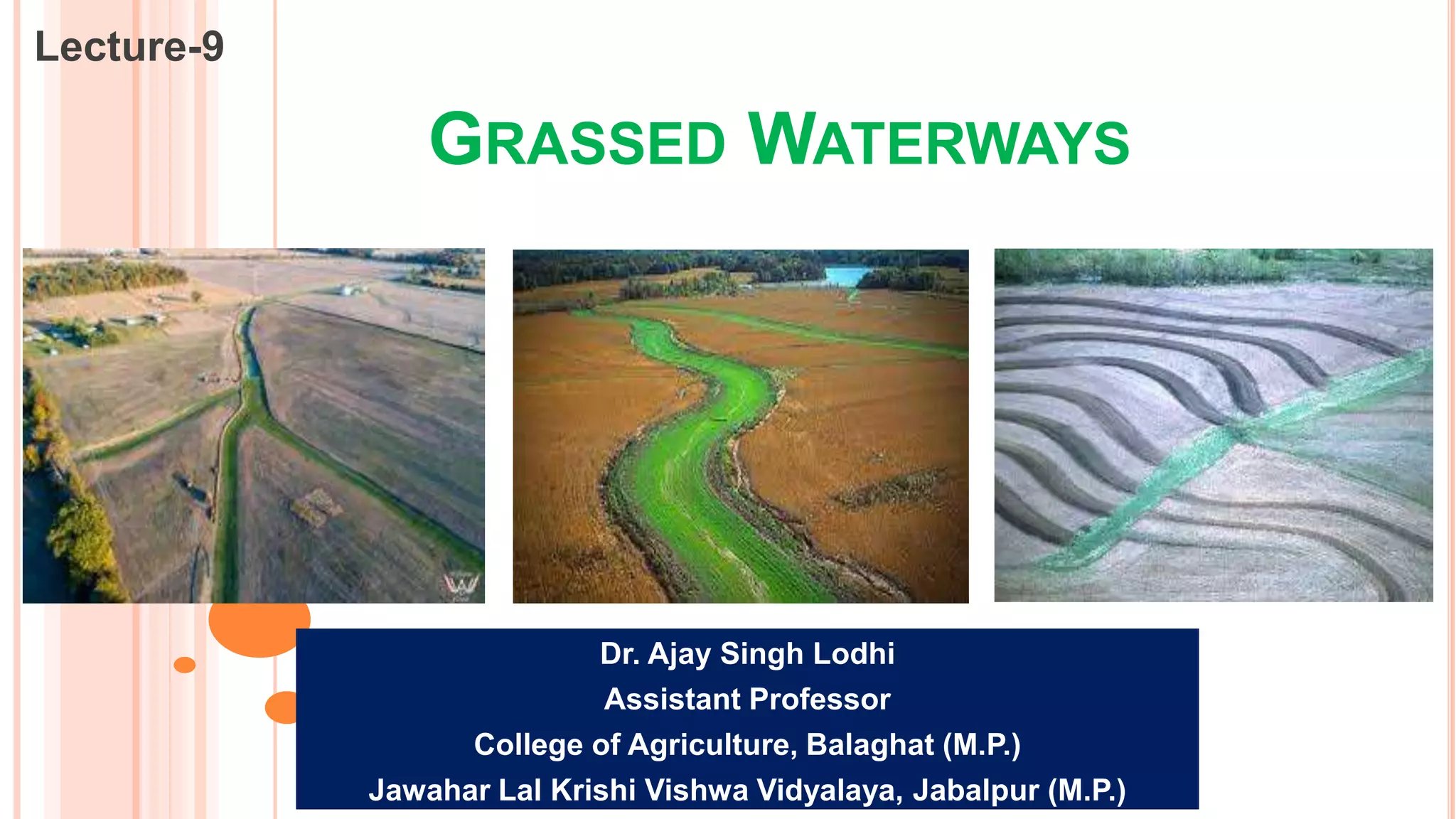
This document discusses grassed waterways, which are natural or man-made channels covered in erosion-resistant grasses that are used to drain surface water from an area. Grassed waterways control soil erosion from runoff by lining the channel with grasses. Their design requires data on watershed characteristics, soil type, and topography to calculate peak runoff rates. Their shape depends on construction equipment availability, flow velocity, grade, and grass cover. Design involves determining peak runoff, assuming a channel cross-section, calculating velocity and capacity using Manning's equation, and iterating assumed dimensions until capacity matches runoff rates.
This presentation includes description about water erosion, types of water erosion i.e. Raindrop erosion, Sheet erosion, Rill erosion, Gully erosion, Stream bank erosion, Sea-shore erosion Landslide/ slip erosion and Tunnel erosion.
Water Erosion Control Measures- Agricultural Lands.pptxAjay Singh Lodhi
This presentation describes about agronomical measures to control water erosion. It includes Crop rotation, crop cover, contour cultivation, strip cropping and mulch tillage practices.
This presentation describes gully erosion, development of gullies, stages of gully development, classification of gullies based of shape, state and size.
This presentation includes definition of Soil Erosion, Causes of Soil Erosion, Types of Soil Erosion, Agents of Soil Erosion, Factors Affecting Soil Erosion, Mechanics of Soil Erosion and
Ill Effects of Soil Erosion
Wind Erosion
Effects of Wind Erosion
Factors Affecting Wind Erosion
Mechanics of Wind Erosion
Estimation of Soil Loss Due to Wind Erosion
Wind Erosion Control Measures
Wind Breaks
Shelter Belts
wind erosion and its control measures, factor affecting wind erosion, mechanics of wind erosion, types of soil transportation, suspension, saltation and surface creep, windbreak, shelterbelt, sand duns
For More Visit - www.civilengineeringadda.com
Irrigation Efficiency
Water conveyance Efficiency
It takes into account, conveyance or transit losses such as seepage through canal and evaporation through it.
η_c=W_f/W_r ×100
Where, Wf = water delivered to the field
Wr = water delivered from river or stream
Water Application Efficiency
It is the ratio of water stored in root zone to the water delivered to the field.
η_a=W_s/W_f ×100
Where, WS = water weight stored in root zone
WS = Wf – deep percolation – runoff
Wf = water delivered to the field
This efficiency is also called as farm efficiency and it depends on the irrigation technique that has been adopted.
Water use efficiency
It is the ratio of water used beneficially or consumptively to the water delivered to the field.
η_u=W_u/W_f ×100
Where, Wf = water delivered to the field
WU = consumptively used water
Water Storage Efficiency
This is the ratio of actual water stored in the root zone to the water needed to be stored to bring the moisture content upto field capacity.
Water Distribution efficiency
This evaluate the degree to which water is uniformly distributed to the root zone throughout the field area.
η_d=(1-y/d)×100
Where, d = average depth
y = Average numerical deviation in the depth of water stored from the average depth stored during irrigation
Question – the depths of penetration along the length of a border strip at points 30 m apart were proved. There observed values are 2 m, 1.9 m, 1.8 m, 1.6 m and 1.5 m. Compute the water distribution efficiency.
Solution –
Water distribution efficiency,
η_d=(1-y/d)×100
Where, d = average depth
d = (2+1.9+1.8+1.6+1.5)/5=1.76
And y = average numerical deviation
y = 1/5((2-1.76)+(1.9-1.76)+(1.8-1.76)+(1.76-1.6)+(1.76-1.5)=0.168
Therefore,
η_d=(1-0.168/1.76)×100
η_d=90.45%
Consumptive Use Efficiency
It is the ratio of water used consumptively to the net amount of water from the root zone.
Soil erosion by water- factors and mechanism.pptxanju bala
water erosion is the detachment, transportation and deposition of soil particles from one place to another by the force of water
Soil erosion by the water is the result of rain detaching and transporting of vulnerable soil, either directly by means of rain splash or indirectly by rill and gully erosion.
Universal soil loss equation, soil loss estimation, factors of USLE, its use and limitation, soil loss measurement by multi slot divisor and coshocton wheel sampler
Bio engineering methods and their control for soil erosionSantosh pathak
integrated technology that uses sound engineering practices in conjuction with ecological principles to: design & construct vegetative living system to prevent erosion,
stabilize shallow areas of soil instability, protect and enhance healthy system. uses live plant materials and flexible engineering techniques to eliminate environmental problems.
describes the irrigation and irrigation requirements of different crops. this ppt also describes about different methods to measure the soil moisture availability.
Lecture notes of Environmental Engineering-II as per Solapur university syllabus of TE CIVIL.
Prepared by
Prof S S Jahagirdar,
Associate Professor,
N K Orchid college of Engg and Technology,
Solapur
Gully Erosion Control Measures
Temporary check dam
Brushwood dams
One row or single post brush wood dam
Double row post brush wood dams.
Semi permanent dams
Loose rock dam
Netting dam
Log check dam
Permanent check dam
Drop Spillway
Drop inlet spillway
Chute spillway
Internal Combustion Engines:- Heat Engines, Classification of heat engines, Construction and principle of IC Engines, Two stroke and Four stroke engine cycle.
Energy Sources, Origin of energy resources, Forms of energy, types of energy resources.
Farm Power, Farm Mechanization- introduction, benefits and advantages.
The Roman Empire A Historical Colossus.pdfkaushalkr1407
The Roman Empire, a vast and enduring power, stands as one of history's most remarkable civilizations, leaving an indelible imprint on the world. It emerged from the Roman Republic, transitioning into an imperial powerhouse under the leadership of Augustus Caesar in 27 BCE. This transformation marked the beginning of an era defined by unprecedented territorial expansion, architectural marvels, and profound cultural influence.
The empire's roots lie in the city of Rome, founded, according to legend, by Romulus in 753 BCE. Over centuries, Rome evolved from a small settlement to a formidable republic, characterized by a complex political system with elected officials and checks on power. However, internal strife, class conflicts, and military ambitions paved the way for the end of the Republic. Julius Caesar’s dictatorship and subsequent assassination in 44 BCE created a power vacuum, leading to a civil war. Octavian, later Augustus, emerged victorious, heralding the Roman Empire’s birth.
Under Augustus, the empire experienced the Pax Romana, a 200-year period of relative peace and stability. Augustus reformed the military, established efficient administrative systems, and initiated grand construction projects. The empire's borders expanded, encompassing territories from Britain to Egypt and from Spain to the Euphrates. Roman legions, renowned for their discipline and engineering prowess, secured and maintained these vast territories, building roads, fortifications, and cities that facilitated control and integration.
The Roman Empire’s society was hierarchical, with a rigid class system. At the top were the patricians, wealthy elites who held significant political power. Below them were the plebeians, free citizens with limited political influence, and the vast numbers of slaves who formed the backbone of the economy. The family unit was central, governed by the paterfamilias, the male head who held absolute authority.
Culturally, the Romans were eclectic, absorbing and adapting elements from the civilizations they encountered, particularly the Greeks. Roman art, literature, and philosophy reflected this synthesis, creating a rich cultural tapestry. Latin, the Roman language, became the lingua franca of the Western world, influencing numerous modern languages.
Roman architecture and engineering achievements were monumental. They perfected the arch, vault, and dome, constructing enduring structures like the Colosseum, Pantheon, and aqueducts. These engineering marvels not only showcased Roman ingenuity but also served practical purposes, from public entertainment to water supply.
Model Attribute Check Company Auto PropertyCeline George
In Odoo, the multi-company feature allows you to manage multiple companies within a single Odoo database instance. Each company can have its own configurations while still sharing common resources such as products, customers, and suppliers.
The French Revolution, which began in 1789, was a period of radical social and political upheaval in France. It marked the decline of absolute monarchies, the rise of secular and democratic republics, and the eventual rise of Napoleon Bonaparte. This revolutionary period is crucial in understanding the transition from feudalism to modernity in Europe.
For more information, visit-www.vavaclasses.com
Palestine last event orientationfvgnh .pptxRaedMohamed3
An EFL lesson about the current events in Palestine. It is intended to be for intermediate students who wish to increase their listening skills through a short lesson in power point.
2024.06.01 Introducing a competency framework for languag learning materials ...Sandy Millin
http://sandymillin.wordpress.com/iateflwebinar2024
Published classroom materials form the basis of syllabuses, drive teacher professional development, and have a potentially huge influence on learners, teachers and education systems. All teachers also create their own materials, whether a few sentences on a blackboard, a highly-structured fully-realised online course, or anything in between. Despite this, the knowledge and skills needed to create effective language learning materials are rarely part of teacher training, and are mostly learnt by trial and error.
Knowledge and skills frameworks, generally called competency frameworks, for ELT teachers, trainers and managers have existed for a few years now. However, until I created one for my MA dissertation, there wasn’t one drawing together what we need to know and do to be able to effectively produce language learning materials.
This webinar will introduce you to my framework, highlighting the key competencies I identified from my research. It will also show how anybody involved in language teaching (any language, not just English!), teacher training, managing schools or developing language learning materials can benefit from using the framework.
How to Split Bills in the Odoo 17 POS ModuleCeline George
Bills have a main role in point of sale procedure. It will help to track sales, handling payments and giving receipts to customers. Bill splitting also has an important role in POS. For example, If some friends come together for dinner and if they want to divide the bill then it is possible by POS bill splitting. This slide will show how to split bills in odoo 17 POS.
Unit 8 - Information and Communication Technology (Paper I).pdfThiyagu K
This slides describes the basic concepts of ICT, basics of Email, Emerging Technology and Digital Initiatives in Education. This presentations aligns with the UGC Paper I syllabus.
This is a presentation by Dada Robert in a Your Skill Boost masterclass organised by the Excellence Foundation for South Sudan (EFSS) on Saturday, the 25th and Sunday, the 26th of May 2024.
He discussed the concept of quality improvement, emphasizing its applicability to various aspects of life, including personal, project, and program improvements. He defined quality as doing the right thing at the right time in the right way to achieve the best possible results and discussed the concept of the "gap" between what we know and what we do, and how this gap represents the areas we need to improve. He explained the scientific approach to quality improvement, which involves systematic performance analysis, testing and learning, and implementing change ideas. He also highlighted the importance of client focus and a team approach to quality improvement.
1. GRASSED WATERWAYS
Lecture-9
Dr. Ajay Singh Lodhi
Assistant Professor
College of Agriculture, Balaghat (M.P.)
Jawahar Lal Krishi Vishwa Vidyalaya, Jabalpur (M.P.)
2. GRASSED WATERWAYS
Grassed waterways are the natural or man made water courses, covered with
erosion resistant grasses, used to dispose surface water from the area.
The use of grasses in the section of waterway, acts as a lining material to control
the problem of soil erosion, caused by haphazard runoff flow through the section.
The grassed waterways are constructed along the slope of the area.
Apart from disposing the runoff from area, these waterways also act as an outlet
for the terraces or graded bunds.
Waterways are counted as important tool for removing surplus water from the
terraced field, and for erosion control work.
The grassed water ways should be fully established with grasses before water is
turned into them. In other words, in the area the waterways should be ready to
hold water before bunds, terraces, or diversions etc. are being constructed.
3. DATA REQUIRED FOR DESIGNIG OF WATERWAYS
Watershed area along with the informations on soil characteristics, crop cover and
topography. This data is basically required for computing the peak runoff rate of the
watershed on the basis of which the grassed water ways are designed.
Grade of the proposed waterway (in percent). It is fixed by accounting the elevation of
outlet.
For selecting the roughness coefficient, the information on vegetal cover adopted to the
site, is also needed.
Erodibility of the soil of grassed waterway. It is required to predict the soil erosion likely
to made through the waterway, till the vegetations or grasses get fully established in the
cross-section.
Allowable flow velocity suitable to the condition of waterway.
Allowance to be provided to the cross-section of waterway for compensating the space,
occupied by the vegetations.
Additional depth as 'free board' to be added to the depth of waterways for removing the
chances of overtopping from the top of the waterway.
4. Factors Affecting the Waterways
The shapes of grassed waterways are of three types:
Trapezoidal
Triangular
Parabolic
5. A parabolic shaped waterway represents a natural channel.
In normal course of water flow, the trapezoidal and triangular sections become
parabolic in shape due to deposition of sediments over the channel section and
bank erosion.
The factors that affect the selection of shape of waterways are:
Construction equipment availability
Velocity of flow
Grade of the waterway
The type of grass cover
6. 1. Construction Equipment Availability
The equipment available for construction of the waterway is one of the main factors.
Trapezoidal shaped channel can easily be constructed with the blade type machines
provided that the design bottom width of the channel is greater than the minimum width
of the cut of the equipment.
If the design bottom width of the trapezoidal channel is narrower than the width of the
mower swath, then construction is not possible, because neither equipment can move
nor desired width of the waterway can be achieved.
Similarly, triangular and parabolic shaped channel with side slope of 4:1 or flatter can
easily be constructed by using suitable equipment.
From construction point of view, the trapezoidal cross section can easily be constructed
and widely used where the waterway is artificially constructed as terrace outlets along
the boundary line.
Trapezoidal and triangular cross-section of channel, after some time, is liable to take the
form of parabolic section either due to siltation at the bottom or due to scouring of the
soil from its bottom and sides. That is why parabolic shape of grassed waterway is
generally considered as most economical and also a more stable cross section.
7. 2. Velocity of Flow:
The permissible flow velocity in the grassed waterway depends upon the type and
condition of vegetation and its density to resist the erosion.
A uniform vegetative cover in the waterway is important to provide a better channel
stability and also to decide the permissible flow velocity.
Permissible velocity in grassed waterways varies according to the vegetative growth.
The approximate values of permissible flow velocity for different grassed cover are
given as:
For an average condition of grassed cover and channel section, a flow velocity from
1.5 to 2.0 m/s is used for design purposes. In grassed waterways, the average flow
velocity is always higher than the actual velocity near the bed, as surface roughness
is greater.
8. 3. Grade of the Waterway
Normally, a channel grade of approximately 5% is recommended for vegetated
waterways. A grade of more than 10% is not recommended, as it is likely to become
erosive. Vegetated waterways are generally constructed along the direction of the
slope.
4. Grass Cover
The grass cover increases the factor of roughness which reduces the velocity of flow
and the channel hydraulic capacity, and along with it, the velocity is made safe (non-
erosive) for the runoff to pass through the channel.
The value of Manning’s roughness factor (n) is not constant for any given species of
grass, but varies with the depth and the velocity of flow and the submergence level
of grass.
When the depth of flow is less, the water seeps through the stems of the grass,
which reduces the flow velocity considerably as the resistance to the flow is very
high with a high value of ‘n’.
The value of roughness coefficient ‘n’ usually taken as 0.04 for design of
grassed waterways.
9. Design of Grassed Waterways
In cases, where the shape of the waterway, the carrying capacity, and the slope of the
bed are known, the procedure for the design of the channel parameters comprises of
the following steps.
Step 1: Determine the peek runoff rate, generated from the area which is needed to
drain through the waterway. The area to be drained (A) may be obtained from the
contour map. The peak runoff rate (Q) is estimated using the rational formula given as
under
10. Design of Grassed Waterways
In cases, where the shape of the waterway, the carrying capacity, and the slope of the
bed are known, the procedure for the design of the channel parameters comprises of
the following steps.
Step 2: Assume the value of flow depth and calculate the channel cross sectional area
(A), wetted perimeter (P), hydraulic radius (R) and top width (t)
(A) For trapezoidal channel section
Where: b = bottom width (m), d = channel depth (m)
Z = e/d =side slope (horizontal: vertical) of trapezoidal channel
13. Step 3: Determine the mean velocity of flow by using manning’s formula which states
that
Where,
R= hydraulic radius of the channel section (m)
S = channel grade
n = Manning’s roughness co-efficient (for vegetated waterways, n= 0.04)
Step 4: Determine the discharge rate Q = Av (m3/s) through the channel.
Step 5: Check if the velocity is safe, and the carrying capacity of the channel is within
the permissible range. (Computed capacity of waterway is equal or nearly equal to the
peak runoff rate).
14. Step 6: If it is observed that the velocity is unsafe, and the carrying capacity is not
within the permissible range, and then repeat the process with another set of assumed
value in step (1), till the carrying capacity is found to be within the permissible range.
Step 7: A free board of 15 cm is then added to the assuming channel depth as