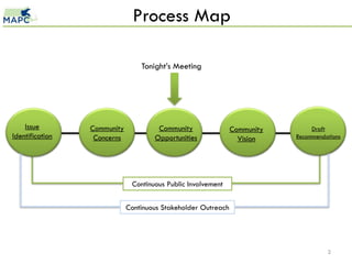
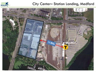
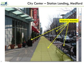
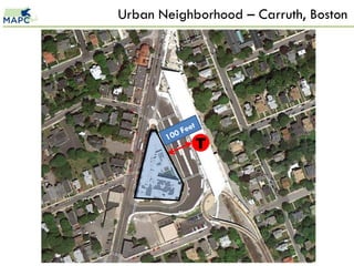
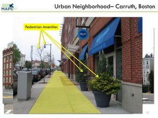
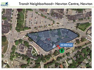
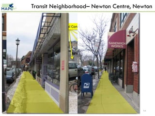
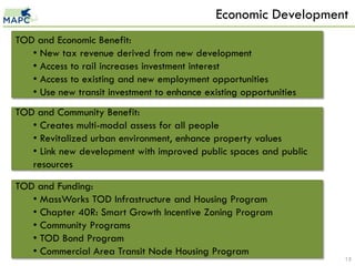
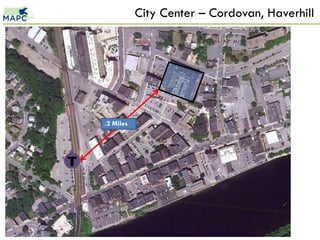
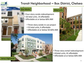
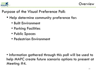
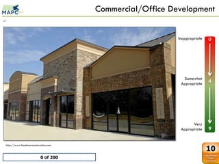
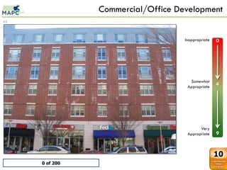
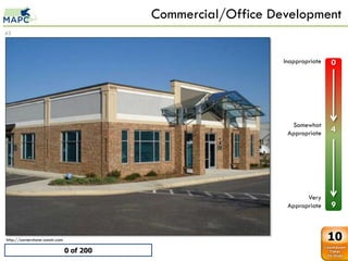
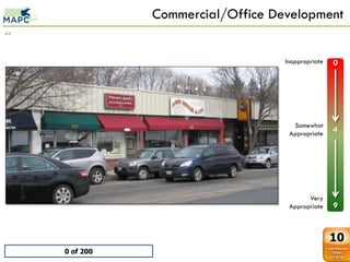
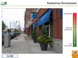
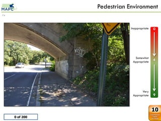
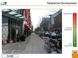
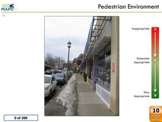
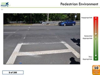
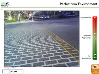
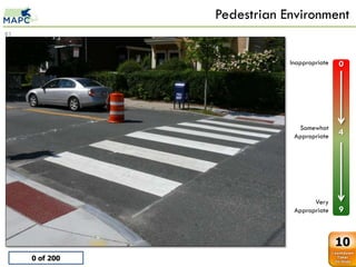
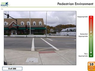
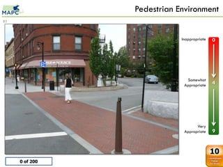
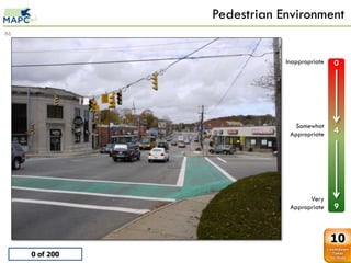
This document discusses a community meeting about developing a vision for land around the proposed Mystic Valley Parkway Green Line extension. It includes an overview of transit-oriented development, describing its benefits and key characteristics like density and mixed uses. Examples are provided of TOD projects at different scales incorporating housing, retail, and public spaces. Economic impacts and funding sources for TOD are also reviewed. The meeting aims to gather community preferences through a visual poll to help plan future development scenarios.
Smart Growth (A21): The wolf at your front door (part 2)Patti Gettinger
Threats to private property rights from smart growth policies (aka sustainable development, livable communities, Agenda 21), including eminent domain and restrictions to mobility are based on failed socialist models.
Creating a Complete Street Active Transportation Network - Marita RoosBikeTexas
The document summarizes San Antonio's Complete Streets Initiative. It discusses:
1) The timeline of the initiative from 2010-2020, including adopting a Complete Streets policy in 2011.
2) Key points of the Complete Streets policy passed by City Council in 2011, which supports multimodal transportation and enhancing public spaces.
3) Current activities like project scoping, training staff in evaluation tools, and beginning construction of pilot streets in 2013.
High Density and Livability: Lessons Learned in Asian Cities (Sujata Govada) ...Virtual ULI
This document discusses lessons learned from high-density Asian cities regarding livability. It explores what makes high density work through examples of Asian cities like Hong Kong, which is highly dense yet livable due to infrastructure, transit mobility, and open green spaces comprising 40% of its land. Principles for sustainable development include balancing new development with heritage, and focusing on placemaking, connectivity, and integrating development within the existing urban fabric at an appropriate scale.
Project posters describing some of the projects completed under the MAPC's Sustainable Communities Regional Planning Grant. The posters were displayed at the final meeting of the Sustainable Communities Consortium on May 21, 2014, Boston, Massachusetts.
The document summarizes a presentation on bringing financial reality to the redevelopment of Madison Square in South Miami, Florida. It discusses:
1) The existing conditions of Madison Square including land uses, demographics, and political concerns about development densities.
2) How proformas were used to analyze development scenarios and determine financially viable densities and heights for redevelopment.
3) The recommended scenario which proposed a higher density neighborhood center with mixed uses and increased heights and densities to make the project economically feasible while being compatible with the surrounding neighborhood.
The document is a portfolio from landscape architect J. Christopher Ray showcasing several of his design projects. It includes summaries of a scattered site urban infill redevelopment in Hazelwood that incorporates new pedestrian pathways, a design for a living wall at UPMC Mercy Hospital using a double helix pattern, and a master plan for a 59-acre site in Cranberry Township featuring mixed-use development organized around preserved green spaces. The portfolio demonstrates Ray's focus on connecting spaces to their contexts and users through thoughtful forms and arrangements.
Presentation at TOD training program by ADB - covering TOD basics, 5 TOD principles, What is TOD, Sustainability, Delhi, Bangaluru, ADB, ADB training, National TOD Policy, Pedestrian, Walkability, NMT, Non motorized transport, Women Safety, Setbacks, Women friendly environment, women oriented urban design, urban design, urban planning, Street safety, natural surveillance, Connectivity, Network planning, Pedshed analysis, multimodal integration, Form Based Codes, DDA, IRSDC, MOHUA, Ministry of Housing and Urban Affairs, Railways, Delhi Development Authority, Karol Bagh, Ajmal Khan, Pedestrianization, Affordable Housing, Karkadooma, Recycling, Daylighting, Energy modeling
Here are the key points relating the Economic Development Strategy to where development should be focused in Greater Downtown Waco given its large size:
- Focus initial catalytic projects in areas that will have the biggest impact, such as near existing assets like Heritage Square and City Hall. Smaller pilot projects can activate underutilized spaces.
- Prioritize areas with potential for high density, mixed-use development within walking distance of the core downtown and transit stops. This includes areas near Baylor and along major corridors leading to other activity centers.
- Leverage Greater Downtown's assets like the Baylor campus, libraries, parks and open spaces by concentrating new development in surrounding areas to create active hubs connected by improved pedestrian and transit infrastructure.
Here are the key points relating the Economic Development Strategy to where development should be focused in Greater Downtown Waco given its large size:
- Focus initial catalytic projects in areas that will have the biggest impact, such as near existing assets like Heritage Square and City Hall. Smaller pilot projects can activate underutilized spaces.
- Prioritize areas with potential for high density, mixed-use development within walking distance of the core downtown and transit stops. This will support an 18-hour live-work-play environment.
- Direct growth along transit corridors to key activity centers like Baylor University, the Zoo, and the Waterfront to leverage planned transit investments and connect these destinations.
- Target entrepreneurial retailers/restaurants to
The document summarizes the Memphis 3.0 Comprehensive Plan, which provides a framework to guide future growth, investment, and planning in Memphis. The plan was created through an extensive community engagement process involving over 15,000 participants. It defines "anchors" as mixed-use areas to focus growth and defines 10 street types to classify streets at different levels. The plan also outlines goals and actions around land use, connectivity, and opportunities to make Memphis a more sustainable, equitable and livable city in the coming decades.
This document presents the Cradle City Master Plan, outlining development proposals for the Amari land holdings within the Lanseria Precinct Development Framework. The purpose is to establish a vision, objectives, and development plan that aligns with spatial planning policies of the City of Johannesburg, Mogale City, and City of Tshwane. Key elements include establishing partnerships with local authorities, an environmentally responsible development, inclusionary housing, and infrastructure development to enable coordinated phased growth. The master plan provides an overall structure, land uses, movement systems, services infrastructure, and proposed phasing to unlock the economic potential of the area as a regional node as envisioned in the Gauteng Growth and Development Strategy
The document summarizes Ontario's updated 2012 Transit-Supportive Guidelines. The guidelines were first published in 1992 and provide strategies to assist municipalities in creating transit-supportive land use and increasing ridership. The 2012 update expands on land use and introduces new chapters on improving transit services. It aims to support provincial growth plans and priorities by encouraging compact, mixed-use development near transit.
Development control regulations kochi reportGeeva Chandana
The document summarizes the development control regulations for the Kochi City Region in Kerala, India. It provides an overview of the planning area and divisions, estimated future land requirements, development concepts and strategies, land use categories and regulations, and transport proposals. Key points include that the planning area covers Kochi city and surrounding areas, there is a need for more recreational, commercial, and transportation lands, and the goal is to develop Kochi as a global city with diversified industries and improved regional transport links.
As the population of Lahore is increasing day by day and its central hub is getting densely populated, people are demanding for new neighborhoods with self-contained facilities. Therefore new neighborhoods are being developed outside the main city with self-contained facilities. This report is about a neighborhood design of an area in Shadira, Lahore with detailed features and facilities including residential houses, market, shopping centers, parks and open spaces, streets and public buildings.
The document discusses planning for population and economic growth in Perth and the south west region of Western Australia, which is facing challenges around housing affordability, infrastructure demands, and managing sustainable development. It covers various transport and urban planning strategies to guide growth, such as the Network City approach, integrated transport planning by local governments, and transit-oriented development around rail stations to create more livable communities. Congestion issues are also identified on major roads like Kwinana Freeway, Hampton Road, and Cockburn Road that require future upgrades or alternative routes to accommodate increased traffic.
UN Habitat: A new strategy for sustainable neighborhood and its principles.
Key features of sustainable neighbourhoods.
A Neighborhood for Children, Aged & Disabled People.
etc
The Gateway Area Structure Plan (ASP) provides guidance for the development of land in Calgary's western region. Key aspects of the plan include:
- Preserving natural areas like ravines and watercourses while allowing development.
- Creating a connected street grid for walkability and transit access.
- Guiding development to create a complete community with a variety of housing, employment, parks and amenities to serve the planned population of over 27,000 people.
- Emphasizing sustainable development practices.
- Coordinating planning with adjacent communities and Rocky View County based on the Municipal Development Plan.
The document discusses context sensitive solutions (CSS) for designing major urban thoroughfares to make them more walkable. CSS aims to balance safety, mobility, community objectives and the environment. It focuses on tailoring design to the surrounding context, including the street classification and context zone. CSS emphasizes flexibility, multimodal transportation prioritizing pedestrians and bicyclists, and public involvement. Street design elements like roadside zones, intersections and networks are discussed in relation to creating walkable environments.
The document discusses building great neighbourhoods in Red Deer through careful planning and design. It outlines nine principles for creating neighbourhoods that are sustainable, walkable, vibrant, and livable. These include considering natural areas, a mix of land uses, connectivity through various transportation options, compact urban form and density, parks and community spaces, housing variety, resilience and sustainability, safety, and unique identity. The standards provide guidance for both new neighbourhood developments and smaller redevelopment within existing areas to achieve well-designed neighbourhoods that improve quality of life.
The document summarizes a study on restructuring Shah Jamal Colony in Lahore, Pakistan. It describes the existing conditions, including high population density, lack of amenities and infrastructure, and chaotic housing arrangements. The aim is to redevelop the area through participatory design, upgrading housing, providing basic services, and improving connectivity and circulation to activate Shah Jamal as a major neighborhood. Historical mappings show the origins of settlements around Shah Jamal shrine in the 17th century and subsequent growth.
This presentation was given by COE Pune for "Samavesh" - XVl Annual NOSPlan Convention. The Theme of Presentation - "Accessibility in Peri-urban area".
Jasper Downtown Riverfront Master Plan draftMatthew Crane
The document presents a master plan for downtown Jasper and the Patoka Riverfront. It identifies key areas for improvement, including Courthouse Square, enhancing connections between the downtown and riverfront, and reusing former industrial properties. The plan provides strategies and an action plan to strengthen these areas and create a more vibrant downtown district that capitalizes on recent investments along the riverfront.
The virtual public meeting presented the draft Broadview Heights Master Plan. It reviewed the planning process, summarized feedback from the previous public meeting, outlined the implementation document and process, and requested input on prioritizing goals and strategies. Residents were asked to provide priority rankings for strategies online by July 19th to help finalize the plan. The meeting highlighted trails, road improvements, design guidelines, and planning concept area updates based on previous public comments.
Using a private cloud to automate and govern enterprise developmentWSO2
The document discusses how using a private cloud platform like WSO2 Stratos can help organizations overcome challenges in enterprise application development by providing an integrated development environment that allows for self-service provisioning of projects, automated governance of libraries and frameworks used, and metrics on code quality and testing through integration with development tools. Stratos aims to provide an on-demand, automated solution for managing the entire application lifecycle from a centralized platform.
Livpure Magna user manual best RO UV UF water purifier in India most advanced...Livpure Water
Livpure Magna RO, UV and UF the best water purifier and the most intelligent water purifier in India it works though the suspended particles, macro molecules turbidity and large non dissolved particulate matter. The water passed through the sediment filter which removes fine and coarse particulate impurities from water.
La Enfermedad de Alzheimer es una enfermedad degenerativa del cerebro sin cura que causa deterioro progresivo de la memoria, el razonamiento y otras capacidades cognitivas. Se cree que está causada por la acumulación anormal de proteínas como la beta amiloide y los enredos neurofibrilares, lo que daña y mata las neuronas. Los síntomas incluyen pérdida de memoria, desorientación y cambios de personalidad que empeoran a medida que avanza la enfermedad.
Here are the key points relating the Economic Development Strategy to where development should be focused in Greater Downtown Waco given its large size:
- Focus initial catalytic projects in areas that will have the biggest impact, such as near existing assets like Heritage Square and City Hall. Smaller pilot projects can activate underutilized spaces.
- Prioritize areas with potential for high density, mixed-use development within walking distance of the core downtown and transit stops. This includes areas near Baylor and along major corridors leading to other activity centers.
- Leverage Greater Downtown's assets like the Baylor campus, libraries, parks and open spaces by concentrating new development in surrounding areas to create active hubs connected by improved pedestrian and transit infrastructure.
Here are the key points relating the Economic Development Strategy to where development should be focused in Greater Downtown Waco given its large size:
- Focus initial catalytic projects in areas that will have the biggest impact, such as near existing assets like Heritage Square and City Hall. Smaller pilot projects can activate underutilized spaces.
- Prioritize areas with potential for high density, mixed-use development within walking distance of the core downtown and transit stops. This will support an 18-hour live-work-play environment.
- Direct growth along transit corridors to key activity centers like Baylor University, the Zoo, and the Waterfront to leverage planned transit investments and connect these destinations.
- Target entrepreneurial retailers/restaurants to
The document summarizes the Memphis 3.0 Comprehensive Plan, which provides a framework to guide future growth, investment, and planning in Memphis. The plan was created through an extensive community engagement process involving over 15,000 participants. It defines "anchors" as mixed-use areas to focus growth and defines 10 street types to classify streets at different levels. The plan also outlines goals and actions around land use, connectivity, and opportunities to make Memphis a more sustainable, equitable and livable city in the coming decades.
This document presents the Cradle City Master Plan, outlining development proposals for the Amari land holdings within the Lanseria Precinct Development Framework. The purpose is to establish a vision, objectives, and development plan that aligns with spatial planning policies of the City of Johannesburg, Mogale City, and City of Tshwane. Key elements include establishing partnerships with local authorities, an environmentally responsible development, inclusionary housing, and infrastructure development to enable coordinated phased growth. The master plan provides an overall structure, land uses, movement systems, services infrastructure, and proposed phasing to unlock the economic potential of the area as a regional node as envisioned in the Gauteng Growth and Development Strategy
The document summarizes Ontario's updated 2012 Transit-Supportive Guidelines. The guidelines were first published in 1992 and provide strategies to assist municipalities in creating transit-supportive land use and increasing ridership. The 2012 update expands on land use and introduces new chapters on improving transit services. It aims to support provincial growth plans and priorities by encouraging compact, mixed-use development near transit.
Development control regulations kochi reportGeeva Chandana
The document summarizes the development control regulations for the Kochi City Region in Kerala, India. It provides an overview of the planning area and divisions, estimated future land requirements, development concepts and strategies, land use categories and regulations, and transport proposals. Key points include that the planning area covers Kochi city and surrounding areas, there is a need for more recreational, commercial, and transportation lands, and the goal is to develop Kochi as a global city with diversified industries and improved regional transport links.
As the population of Lahore is increasing day by day and its central hub is getting densely populated, people are demanding for new neighborhoods with self-contained facilities. Therefore new neighborhoods are being developed outside the main city with self-contained facilities. This report is about a neighborhood design of an area in Shadira, Lahore with detailed features and facilities including residential houses, market, shopping centers, parks and open spaces, streets and public buildings.
The document discusses planning for population and economic growth in Perth and the south west region of Western Australia, which is facing challenges around housing affordability, infrastructure demands, and managing sustainable development. It covers various transport and urban planning strategies to guide growth, such as the Network City approach, integrated transport planning by local governments, and transit-oriented development around rail stations to create more livable communities. Congestion issues are also identified on major roads like Kwinana Freeway, Hampton Road, and Cockburn Road that require future upgrades or alternative routes to accommodate increased traffic.
UN Habitat: A new strategy for sustainable neighborhood and its principles.
Key features of sustainable neighbourhoods.
A Neighborhood for Children, Aged & Disabled People.
etc
The Gateway Area Structure Plan (ASP) provides guidance for the development of land in Calgary's western region. Key aspects of the plan include:
- Preserving natural areas like ravines and watercourses while allowing development.
- Creating a connected street grid for walkability and transit access.
- Guiding development to create a complete community with a variety of housing, employment, parks and amenities to serve the planned population of over 27,000 people.
- Emphasizing sustainable development practices.
- Coordinating planning with adjacent communities and Rocky View County based on the Municipal Development Plan.
The document discusses context sensitive solutions (CSS) for designing major urban thoroughfares to make them more walkable. CSS aims to balance safety, mobility, community objectives and the environment. It focuses on tailoring design to the surrounding context, including the street classification and context zone. CSS emphasizes flexibility, multimodal transportation prioritizing pedestrians and bicyclists, and public involvement. Street design elements like roadside zones, intersections and networks are discussed in relation to creating walkable environments.
The document discusses building great neighbourhoods in Red Deer through careful planning and design. It outlines nine principles for creating neighbourhoods that are sustainable, walkable, vibrant, and livable. These include considering natural areas, a mix of land uses, connectivity through various transportation options, compact urban form and density, parks and community spaces, housing variety, resilience and sustainability, safety, and unique identity. The standards provide guidance for both new neighbourhood developments and smaller redevelopment within existing areas to achieve well-designed neighbourhoods that improve quality of life.
The document summarizes a study on restructuring Shah Jamal Colony in Lahore, Pakistan. It describes the existing conditions, including high population density, lack of amenities and infrastructure, and chaotic housing arrangements. The aim is to redevelop the area through participatory design, upgrading housing, providing basic services, and improving connectivity and circulation to activate Shah Jamal as a major neighborhood. Historical mappings show the origins of settlements around Shah Jamal shrine in the 17th century and subsequent growth.
This presentation was given by COE Pune for "Samavesh" - XVl Annual NOSPlan Convention. The Theme of Presentation - "Accessibility in Peri-urban area".
Jasper Downtown Riverfront Master Plan draftMatthew Crane
The document presents a master plan for downtown Jasper and the Patoka Riverfront. It identifies key areas for improvement, including Courthouse Square, enhancing connections between the downtown and riverfront, and reusing former industrial properties. The plan provides strategies and an action plan to strengthen these areas and create a more vibrant downtown district that capitalizes on recent investments along the riverfront.
The virtual public meeting presented the draft Broadview Heights Master Plan. It reviewed the planning process, summarized feedback from the previous public meeting, outlined the implementation document and process, and requested input on prioritizing goals and strategies. Residents were asked to provide priority rankings for strategies online by July 19th to help finalize the plan. The meeting highlighted trails, road improvements, design guidelines, and planning concept area updates based on previous public comments.
Using a private cloud to automate and govern enterprise developmentWSO2
The document discusses how using a private cloud platform like WSO2 Stratos can help organizations overcome challenges in enterprise application development by providing an integrated development environment that allows for self-service provisioning of projects, automated governance of libraries and frameworks used, and metrics on code quality and testing through integration with development tools. Stratos aims to provide an on-demand, automated solution for managing the entire application lifecycle from a centralized platform.
Livpure Magna user manual best RO UV UF water purifier in India most advanced...Livpure Water
Livpure Magna RO, UV and UF the best water purifier and the most intelligent water purifier in India it works though the suspended particles, macro molecules turbidity and large non dissolved particulate matter. The water passed through the sediment filter which removes fine and coarse particulate impurities from water.
La Enfermedad de Alzheimer es una enfermedad degenerativa del cerebro sin cura que causa deterioro progresivo de la memoria, el razonamiento y otras capacidades cognitivas. Se cree que está causada por la acumulación anormal de proteínas como la beta amiloide y los enredos neurofibrilares, lo que daña y mata las neuronas. Los síntomas incluyen pérdida de memoria, desorientación y cambios de personalidad que empeoran a medida que avanza la enfermedad.
Magnet Capital provides restructuring services and consulting to companies facing challenges. It attracts experienced professionals through its network to address each client's unique needs. The company diagnoses issues, develops strategies, and guides implementation through advisory roles or placing full-time talent. Magnet Capital's model offers customized solutions efficiently through flexibly sourcing top experts across industries and geographies. It has successfully helped clients in sectors like consumer goods, media, and sports.
Tema 4 – valoración critica de la informaciónAdrian Puche
Este documento evalúa y compara dos fuentes de información sobre la menopausia y osteoporosis: Medline Plus y PubMed. Ambas son páginas web gubernamentales con información actualizada en 2011 de manera gratuita y accesible sin necesidad de usuario. Si bien ambas son fuentes confiables, Medline Plus provee información más fácil de entender mientras que PubMed contiene datos más técnicos y completos.
The document discusses how companies can original equipment manufacturer (OEM) WSO2's middleware products. It describes WSO2's middleware stack, how other companies have OEM'd it, and the benefits of partnering with WSO2. It outlines WSO2's approach to open source, commercial models for OEM partnerships, and provides engagement options like quickstart, development support, and production support.
The document discusses security issues with the traditional method of third-party applications accessing user resources using resource owner passwords. Specifically, it notes that passwords must be stored insecurely, access cannot be restricted or revoked for individual third parties, and compromise of a third party results in compromise of the user's password and all protected data. The document introduces OAuth as a solution to address these issues using mechanisms such as access tokens and authorization codes to control third party access.
The document provides an update on the Legacy family. It discusses the new larger home built by Simdra at Boolprop. It then discusses the various children and grandchildren, including what some are studying in college. Gem wants to study fashion at Sim State like her cousin Kaitlyn. The document discusses Rosie and the twins, Rebecca and Keira. It notes Gem's mother wants her to study elsewhere. Madeline and Addie then discuss Edwin forcing Kimberly to write an essay about killing herself and their opinions on his actions.
Ted Tye presented two case studies of transit oriented development projects using innovative zoning strategies:
1) Station Landing in Medford redeveloped a suburban office park into a mixed-use development through comprehensive rezoning. This allowed for 600 residential units, stores, and offices connected to the MBTA station.
2) Woodland Station in Newton used 40B affordable housing zoning to redevelop a parking lot into housing near the MBTA despite constraints of the existing public use zoning. This created new affordable housing units and parking for the transit station.
Both projects showed how innovative zoning approaches can successfully promote transit oriented development when existing zoning does not support the density and mixed uses needed. The developments have been well occupied with residents
City Ave Special Services District - Broker PresentationGreg Thomas
The document summarizes plans to revitalize the CityAve area through new zoning that encourages higher density mixed-use development. The zoning aims to transform CityAve from auto-oriented to pedestrian-friendly by increasing building density and heights, reducing parking, and adding open spaces and wider sidewalks. This is expected to attract new residential, office, retail and recreational development, enhancing the area's economic opportunities and creating a more vibrant live-work-play community.
This document discusses how placemaking can transform transit facilities into vibrant community destinations that support walking and biking. It outlines key attributes of great transit places, including amenities, activities, and design features. Placemaking leverages existing infrastructure and local assets to transform public spaces through lower-cost improvements and programming. The placemaking process involves community mapping, audits, and visioning exercises. Strategies for transit-oriented development include making stations into community focal points and ensuring safe and convenient pedestrian and bicycle access. TOD can provide economic and quality of life benefits when implemented through collaborative community engagement.
This document summarizes a discussion on preserving affordable rental housing near transit. It describes the work of four organizations: Mt. Baker Housing Association, which acquires and renovates affordable housing near transit in Seattle; Progressive Redevelopment, which developed affordable housing near a light rail expansion in Atlanta; National Housing Trust, which preserves affordable housing near transit in Washington D.C.; and Urban Land Conservancy, which acquires land along future transit corridors in Denver to preserve affordable housing. Representatives from these organizations discussed case studies of their projects and innovative funding strategies for acquiring and developing affordable housing near transit.
2040 RTP October 2012 Public Workshop Presentation CHCRPA
The document outlines the public involvement process for the 2040 Regional Transportation Plan. It describes workshops on October 22-23 where the public can provide input on goals and priorities, as well as proposed transportation investments. Attendees will be able to participate in stations on safety, transit, system preservation, and congestion to help identify key issues and locations of concern. The plan will be developed over the next year with input from committees, workshops, interviews, and public meetings to create a fiscally constrained 20-year regional transportation plan.
Transit-oriented development (TOD) aims to integrate land use and transportation systems to bring activities, buildings, and public spaces together around transit stations to promote walkability and transit ridership. Key components of TOD include high density, mixed-use development within a 10 minute walk of transit stations, with pedestrian and cyclist infrastructure prioritized. Benefits include reduced traffic, higher property values, and more sustainable transportation patterns. Successful TOD relies on quality public transit, active transportation, mixed land uses, density, and public spaces centered around transit.
This document summarizes a panel discussion on cultivating transit-oriented communities in Connecticut and New England. The panel discussed three case studies: updating an established TOD in Stamford, CT; setting the stage for a regional center TOD in Bridgeport, CT; and a regional center TOD in motion in Somerville, MA. Key challenges discussed included lack of vision, zoning issues, infrastructure costs, and land control. The panel also addressed goals like economic development, housing, and multimodal access.
Public Transportation Funding: Who Pays, Who Benefits and What's the Impact o...Urban Habitat
In 2014 there will potentially be transportation funding and infrastructure ballot measures in several Bay Area Counties. The largest burden of these measures, potentially more than $10 billion over 25 years, will be paid by low income and working class communities.
But how do we ensure these investments benefit the communities who will pay and who depend most on public transportation? What happens when these new transit investments follow market rate development and cause increased displacement? Can transportation investments, transit oriented development and equitable development co-exist?
Introduction by Bob Allen of Urban Habitat
Featured speakers:
Alicia Garza, Executive Director, POWER
Peter Cohen, Co-Director, Council of Community Housing Organizations (CCHO)
This panel is part of the Boards and Commissions Leadership Institute's (BCLI)
Current Issues Series of Urban Habitat.
Policy Forum Series: Zimmerman - Transit Oriented Development-Addressing the ...Environmental Initiative
This document discusses transit oriented development (TOD) and the opportunities it provides for communities. TOD is compact, mixed-use development located within walking distance of transit stations. It improves quality of life by promoting walkability and access to transit. TOD also increases property values and fosters vibrant, mixed-use neighborhoods. Simply locating development near transit is not enough - true TOD requires transit systems designed to support development through convenient access. The document outlines challenges to aligning transit expansion and development but argues that capitalizing on TOD can drive economic growth and equitable opportunities for communities.
The document discusses strategies for managing urban sprawl in Bangalore through transit-oriented development (TOD). It summarizes WRI India's work promoting compact, connected, and coordinated urban development to avoid long-term lock-in of unsustainable sprawl. Key strategies discussed include developing station area plans and regulations to densify around metro stations, strengthening neighborhoods through neighborhood improvement plans, and scaling these approaches across Bangalore through public-private partnerships and community engagement.
The document provides details on a proposed redevelopment project at 2225 East Lake Street in Minneapolis, Minnesota. The proposal is submitted by L&H Development, LLC to the City of Minneapolis. The proposed project would redevelop 6 acres into a mixed-use transit-oriented development with 500-575 housing units, 80,000 square feet of office space, and space for a farmers market. The development would be phased and include market rate and affordable housing, senior housing, retail/commercial space, and a parking structure. The goals of the project are to create high density transit-oriented development that implements the neighborhood plan and enhances the community.
RV 2014: Urban Circulator Roundtable: Shaping Cities one Challenge at a Time ...Rail~Volution
Urban Circulator Roundtable: Shaping Cities One Challenge at a Time AICP CM 1.5
An urban circulator roundtable? How appropriate! Hear speakers from around the country -- Austin; Atlanta; Minneapolis-St. Paul; Portland-- experienced in different disciplines of urban circulator implementation. Start with short presentations from each unique perspective, then focus on the challenges and issues associated with implementation -- outreach, financing, traffic, etc. -- and how each organization overcame these challenges.
Moderator: Neil McFarlane, General Manager, TriMet, Portland, Oregon
Paul Zebell, Project Manager, Bureau of Transportation, City of Portland, Oregon
April Manlapaz, Transit Project Manager, AECOM, Minneapolis, Minnesota
Derek Benedict, PE, Transportation Engineer, URS Corporation, Austin, Texas
D.J. Baxter, Executive Director, Redevelopment Agency of Salt Lake City, Salt Lake City, Utah
Jim Erkel, Attorney & Program Director, Minnesota Center for Environmental Advocacy, St. Paul, Minnesota
Lisa Gordon, Chief Operating Officer, Atlanta Beltline, Inc., Atlanta, Georgia
Development plan case study (nagpur & lasvegas)ABHI PATEL
The document provides details of the Vision 2045 Downtown Las Vegas Master Plan. It summarizes that Las Vegas is located in the center of the Las Vegas Valley and functions as the urban core region. The master plan was created over 18 months to update the previous centennial plan and guide growth through 2045. It establishes goals around land use, mobility, sustainability, and economic development. The planning process included land use, mobility/sustainability, and economic development components with community participation. The master plan is expected to provide environmental, social, and economic benefits to the downtown community through job creation, affordable housing, open space, and other improvements.
Fairfax County Countywide Transit Network Study: Board of Supervisors Transpo...Fairfax County
The document discusses the proposed High Quality Transit Network Concept being reviewed by the Board of Supervisors Transportation Committee. It provides an overview of the study process and purpose, which is to establish the most effective way to serve planned growth in the County through improved public transit. The proposed concept builds upon existing transit investments to create an interconnected network of commuter and local transit routes, including 104 miles of new routes and 53 new stations integrated with express bus services. It is anticipated to increase transit access and ridership while reducing vehicle travel and encouraging transit-oriented development.
This document outlines a 3D GIS analysis for redevelopment in Mesa, Arizona to facilitate development along a light rail extension into downtown while preserving historic buildings. Key points include:
- Mesa is extending its light rail 3.1 miles into downtown by 2016 to spur transit-oriented development.
- A 3D building inventory of downtown was created to understand how new development may interact with historic structures.
- A plan is being developed with community input to guide mixed-use, higher density development around the light rail route.
- Scenario modeling placed hypothetical housing and commercial space to test redevelopment potential and impacts on historic buildings like the 1893 Alhambra Hotel.
RV 2014: Implementing Equitable TOD: Improving Lives by Rose GrayRail~Volution
Implementing Equitable TOD: Improving Lives AICP CM 1.5
Equitable TOD is more than just development near transit. It is a strategy that envelops the vision, aspirations and interests of low-income stakeholders. Equitable TOD investment provides more housing and transportation choices, new job opportunities, better schools and increased retail. Hear success stories from nonprofit leaders in three distinct market areas who have implemented TOD directly linked to improving the lives of residents with low incomes.
Moderator: Richard Manson, Program Vice President, Local Initiatives Support Corporation, New York, New York
Dean Matsubayashi, Director of Community Economic Development, Little Tokyo Service Center, Los Angeles, California
Gail Latimore, Executive Director, Codman Square Neighborhood Development Corporation, Dorchester, Massachusetts
Rose Gray, Senior Vice President CED, APM, Philadelphia, Pennsylvania
This document discusses smart growth zoning strategies for Massachusetts communities to promote density, affordability, and walkability. It outlines how incentive-based zoning can encourage higher density development in strategic locations through economic incentives. Key recommendations include using subdistricts to customize densities and standards, excluding infrastructure areas from developable areas, allowing non-residential uses, engaging in proactive planning led by design concepts, and carefully selecting sites. Successful initiatives include clear policy intent and regulations to achieve the community's vision through grassroots processes and town meeting votes.
This document discusses steps to transform commercial strips into mixed-use centers. It outlines zoning changes and infrastructure plans proposed by the town of Falmouth, Maine to redevelop an area along Route One. The zoning changes aim to increase density and mix of uses, while infrastructure plans involve underground utilities, improved pedestrian access, and funding through a tax increment financing district. The town seeks to create a more vibrant town center that encourages economic growth and limits sprawl.
Edge City to Real City. The Transformation of Tysons Corner VA and White Flin...Virtual ULI
The document summarizes plans to transform two suburban areas, Tysons Corner, Virginia and White Flint, Maryland, into more urban, transit-oriented places. For Tysons Corner, the plans include developing a grid of streets, increasing densities around future Metro stations, reducing parking requirements, and adding new housing, offices and retail. For White Flint, the plans envision a denser street grid, mixed-use neighborhoods organized around walking, and active ground-floor retail along new streetscapes. Both aim to create vibrant, sustainable communities centered around new transit connections.
This document discusses smart growth and form-based code approaches to community planning. Smart growth encourages compact, walkable development with a mix of uses, housing types, and transportation options. Form-based code regulates physical form to achieve a specific urban context. It uses standards for streets, blocks, and building heights/types to create predictable, vibrant neighborhoods. Both approaches aim to integrate development, reduce sprawl, foster livability and sustainability for people of all ages.
An MIT spinoff called Optimus Ride is developing self-driving vehicle technology. The company was founded by Ryan Chin, a PhD from MIT who worked on several autonomous vehicle projects there. Optimus Ride aims to provide safe, sustainable, and equitable mobility solutions through their technology, which could unlock over $1 trillion in annual savings according to a Morgan Stanley report.
The Mass Drive Clean campaign was created in 2015 using funding from the John Merck Fund to promote electric vehicles (EVs) through test drive events. The campaign was piloted in Massachusetts and San Diego in 2015 and continued in 2016 with local funding. In 2016, the John Merck Fund provided seed funding to expand the campaign into Connecticut and Rhode Island. According to post-test drive surveys, over 70% of participants were more favorably inclined towards EVs and 70% said they were more likely to purchase one after the test drive experience. The next steps of the Mass Drive Clean campaign are to reach a larger, more diverse group of state residents, continue educating about incentives and models, and provide more experiential events
This document summarizes Boston's efforts to research and test autonomous vehicles. It discusses the city's goals of improving safety, access, and mobility. The mayor's office has formed research partnerships and begun testing AVs on city streets. Testing has involved different vehicles and conditions. The document also examines potential AV business models and their impacts. It outlines Boston's work in areas like workforce development and governance to help guide the integration of this new technology.
Electric vehicles (EVs) provide environmental benefits by reducing emissions even when powered by coal-based electricity. EVs also offer lower fuel and maintenance costs compared to gas vehicles. Massachusetts currently has hundreds of EV charging stations and provides incentives for purchasing EVs and installing chargers. Upcoming events will give people test drives to experience EVs firsthand and help more drivers switch to these cleaner vehicles.
The document summarizes an innovative mobility panel at a MAPC Fall Council meeting. The panel discussed the rise of electric vehicles and autonomous vehicles, and how transportation is the largest source of greenhouse gases in Massachusetts. They also addressed critical areas for state and local governments to consider regarding regulatory frameworks, data, land use impacts, infrastructure and parking for new mobility technologies. The panelists represented organizations working on these issues like MAPC, DOER, Optimus Rides, the City of Boston and Reach Strategies.
This document summarizes a presentation on equity in the Metro Boston region. It discusses goals for increasing equity, including reducing segregation, improving access to affordable housing and food, and increasing opportunities for advancement for workers of color. It then reviews trends related to equity across different life stages and demographics since 2011. Key metrics like income inequality, low birth weight, test scores, incarceration rates, labor force participation, and housing cost burden show both improvements in some disparities but also growing inequities in other areas. The presentation concludes that inequity remains significant and is growing, but that policy interventions can help advance equity, though continued work is still needed.
The document provides an overview of Massachusetts' Regulation and Taxation of Marijuana Act, which legalized recreational marijuana use and sales. It discusses the history of medical marijuana in MA, the passage of ballot question 4 in 2016, and outlines the key components of the new law, including allowing personal possession and home cultivation, establishing a regulatory system under the Cannabis Control Commission, implementing licensing for marijuana establishments, and levying a state and local excise tax. A timeline is also presented detailing implementation of the new law between 2017-2019.
1) The document reviews local control options for regulating recreational marijuana establishments under Massachusetts law. It can adopt time, place and manner restrictions or limit numbers through a regulatory referendum.
2) A regulatory referendum requires a ballot question voted on by residents to prohibit establishments, limit retailers to 20% of liquor licenses, or limit numbers to fewer than medical marijuana facilities. However, a consumption referendum can be forced onto the ballot with 10% of voter signatures.
3) Interpretation of some provisions is unclear, such as what constitutes an "area" where medical marijuana facilities operate. Overall municipalities have some local control but face limitations, especially the risk of consumption referendums beyond their direct control.
The document discusses municipal IT collaboration between local governments and school departments. It provides examples of how the Town of Foxborough, MA and Foxborough Public Schools have collaborated on their joint IT operations. They have formed a technology steering committee with stakeholders to identify common needs, prioritize projects, and oversee the shared IT department. The collaboration has allowed them to hire additional IT staff and achieve cost savings while improving services. Overcoming barriers involves managing expectations, communication, and planning for the future.
The document outlines Arlington's IT strategic planning process, including putting together a team, engaging stakeholders, and setting benchmarks. It discusses the core components of the plan, including establishing a vision and mission, inventorying existing IT systems, and defining action steps and measurable outcomes. The plan aims to define the role of the IT department, improve relationships with stakeholders, manage the IT workload, and analyze the network.
The document summarizes the state of IT in Massachusetts government and outlines MassIT's priorities and initiatives to improve digital services. MassIT aims to drive digital transformation across state agencies and support local governments. It discusses findings from an IT review that found low citizen satisfaction with digital services and immature security practices. MassIT plans to invest in core infrastructure, partner with local governments, and facilitate regional collaboration on IT projects and shared services.
We have hired 1 person for IT, saving $25,000 while strengthening our dedicated fiber and adding 24/7 support. IT regionalization has allowed us to hire more staff and save money by sharing resources, making our technology infrastructure more robust with around-the-clock assistance.
Draft recommendations presented by Chris Kuschel of the Metropolitan Area Planning Council at the second public forum of the Natick Center Plan, February 10, 2016, Natick, MA.
The Town of Ashland has a thriving community with engaged residents, businesses, and leaders who work together toward common goals of sustainability, regional collaboration, and excellence in schools. Ashland maintains a strong infrastructure and economy with diverse housing, retail, work, and community spaces. The town is committed to environmental stewardship and transportation options while supporting a vibrant downtown, neighborhoods, and quality of life for all ages and backgrounds.
The Town of Ashland has a thriving community with engaged residents, businesses, and leaders who work together towards common goals of sustainability, regional collaboration, and excellence in education. Ashland maintains a strong infrastructure and economy to support its diverse population with various housing, transportation, employment, and environmental opportunities. The community aims to be sustainable, vibrant, and welcoming to all ages through coordinated efforts outlined in the Ashland Comprehensive Plan.
The document outlines draft land use, housing, economic development, and transportation goals for Ashland. For land use, the top three priorities should be GOAL 1 (accommodate development/preservation through zoning), GOAL 2 (support mixed-use development), and GOAL 3 (consider form-based code). For housing, the top three are GOAL 1 (preserve affordability), GOAL 3 (ensure affordability throughout town), and GOAL 6 (promote diverse/affordable housing). For economic development, the top three are GOAL 1 (vibrant development along corridors/downtown), GOAL 2 (provide planning/technical assistance), and GOAL 3 (implement public facilities/utilities
The document summarizes a community forum held in Ashland, Massachusetts to discuss updating the town's comprehensive plan. It provides an overview of the comprehensive planning process and progress made so far in developing Ashland's plan, including outreach activities and draft goals in key areas like land use, housing, economic development, and transportation. The forum included a presentation of the draft community vision statement and goals, followed by small group discussions for residents to provide input and prioritize goals to guide future growth. The next steps in the planning process were also outlined.
The document summarizes a plan for Natick Center that incorporates previous planning efforts and public input. Some key points:
- Previous plans from 1980-2000s addressed facilities, parking, and design issues.
- Natick's population is growing and its households are shrinking, increasing demand for multi-family and smaller housing units.
- New developments have contributed students to schools, though less than single-family homes typically.
- Most people walk to the commuter rail station, and ridership has increased in recent years.
- The plan gathers public input on housing, retail, transportation, and parking preferences to develop a vision for Natick Center's future.
The document provides information from MAPC's Fall 2015 Council meeting. It includes summaries and data from several MAPC projects:
- An inventory of 169 MAPC projects from the past year that advance MetroFuture goals such as sustainable growth, housing, and transportation. Transportation and healthy environment were the most common project categories.
- A discussion of regional ballot initiatives to raise funds for transportation projects and how Massachusetts municipalities can pursue similar initiatives.
- A project to engage immigrant small business owners in downtown Framingham through outreach efforts and a business owner story tour.
- Planning work in Chelsea around housing, jobs, and health through the lens of equity and quality of life near transit infrastructure.
- A project in Quin
1. Mystic Valley Parkway Green Line
Community Visioning Process
Public Meeting #3
May 17, 2011
1
2. Process Map
Tonight’s Meeting
Issue Community Community Community Draft
Identification Concerns Opportunities Vision Recommendations
Continuous Public Involvement
Continuous Stakeholder Outreach
2
3. Mystic Valley Parkway Green Line - Community Visioning Process
Transit Oriented Development
May 17, 2011
Jennifer Raitt, MAPC
3
4. Overview
Presentation Will Cover:
• What is transit oriented development (TOD)?
• What land use, zoning and design characteristics
make TOD successful?
• What are the economic benefits of TOD?
• How has housing been successfully integrated into
TOD?
4
5. What is transit oriented development?
What is transit oriented development?
“A type of community development that includes a mixture of
housing, office, retail and/or other amenities integrated into
a walkable neighborhood and is located within a half-mile of
quality public transportation.”
Source: Reconnecting America
Potential benefits of transit oriented development include:
• Reduced vehicle travel, lower congestion, better air quality
• Increased access to quality transit and mobility choices
• Improved access to jobs
• Creation of walkable communities benefiting public health
5
6. Why transit oriented development?
Transit oriented development patterns:
Conventional suburban development patterns:
http://www.metroplanning.org
http://www.valleymetro.org
http://www.theslatinreport.com http://www.tkharris.com
http://www.lightrailnow.org
http://nuonline.arc.miami.edu 6
7. Scales of transit oriented development
Transit oriented development can be done at a variety of scales:
Transit Neighborhood
City Center
Urban Neighborhood
7
8. Land Use, Zoning and Design
TOD and Land Use:
• Good mix of uses to create vibrant area
• Mixing uses creates walkable environments
• Need to have residential to support other uses
TOD and Zoning:
• Need strong zoning ordinance to regulate development
• Zoning can help control height, setbacks, density, etc.
• Couple design review with zoning
TOD and Design:
• Good design creates inviting spaces
• Good design enhances existing community character
• Good design fosters multi-modal access 8
15. Economic Development
TOD and Economic Benefit:
• New tax revenue derived from new development
• Access to rail increases investment interest
• Access to existing and new employment opportunities
• Use new transit investment to enhance existing opportunities
TOD and Community Benefit:
• Creates multi-modal assess for all people
• Revitalized urban environment, enhance property values
• Link new development with improved public spaces and public
resources
TOD and Funding:
• MassWorks TOD Infrastructure and Housing Program
• Chapter 40R: Smart Growth Incentive Zoning Program
• Community Programs
• TOD Bond Program
• Commercial Area Transit Node Housing Program
15
17. City Center – Cordovan, Haverhill
Cordovan - Haverhill
• Adaptive re-use of old factory building
• Within walking distance to commuter rail station and
Downtown Haverhill
• MassHousing made $10.6 million in loans
Project contains:
• 146 total housing units, 61 affordable units
• Project received funding through MassHousing’s Priority
Development Fund for “transit-oriented” projects
• Project also received permanent and deferred payment
www.masshousing.org
loans from MassHousing
17
19. Transit Neighborhood– Station Crossing, Melrose
Station Crossing – Melrose
• Redevelopment of abandoned bowling alley
• Within walking distance to two commuter rail stations and
Downtown Melrose
• MassHousing made $9.7 million construction loan
Project contains:
• 48 total housing units, for-sale condominiums
• Five units reserved for affordable housing
• Project brings housing near commercial hub which generates
https://www.masshousing.com
added purchasing power and supports local business
19
20. Housing
Housing Development:
• Adaptive re-use or retrofitting existing buildings
• Redevelopment of existing buildings
• Infill development
• Develop on previously undeveloped land
Types of Housing:
• Market-rate housing
• Mixed-income housing
• Affordable housing
Programs encouraging housing development:
• 40R/Smart Growth Zoning Incentive Program
• Community Development Block Grants
• HOME 20
22. City Center – The Hayes, Haverhill
The Hayes – Downtown Haverhill
• Adaptive re-use of a vacant box factory for the shoe industry
• Part of 53 acre Smart Growth Overlay District in Downtown
Haverhill
Project contains:
• 57 total housing units, rental apartments
• Mix of 1 bedroom and 2 bedroom units
• 52 of 57 units reserved for affordable housing
• 3,200 square feet of ground floor retail space
22
24. Urban Neighborhood– Amory Street, Boston
Amory Street Residences – Boston
• Redevelopment of a vacant parcel in urban neighborhood
• Close proximity to Jackson Square Orange Line station and
nearby commercial/recreational uses
Project contains:
• Two, four and six story components to the building
• 64 total housing units
• Mix of townhomes and apartments
• All 64 units reserved for affordable housing
24
26. Transit Neighborhood – Box District, Chelsea
Box Works Atlas Lofts
• Four-story condo redevelopment
• 26 total units, 14 affordable
• Affordable at or below 60% AMI
• Three-story condo re-use project
• 53 total units, 6 affordable
• Affordable at or below 50-60% AMI
• Three-story rental redevelopment
• 41total units, 41 affordable
• Affordable at or below 60% AMI
Janus Highlands
26
27. Mystic Valley Parkway Green Line
Community Visioning Process
Visual Preference Poll
May 17, 2011
27
28. Overview
Purpose of the Visual Preference Poll:
• Help determine community preference for:
• Built Environment
• Parking Facilities
• Public Spaces
• Pedestrian Environment
• Information gathered through this poll will be used to
help MAPC create future scenario options to present at
Meeting #4.
28
29. Overview
What is in a photo?
• Building styles, height, massing and materials
• Pedestrian/shopper amenities
• Lighting
• Signage and parking
• Other features
What is not in a photo?
• Context of the photo, where is the building located?
• Where the parking is located
• Connectivity among uses
• Physical, Landscape, Design
• Proximity to other buildings or uses
29
30. Overview
Instructions for Visual Preference Poll:
• Photos are grouped by category
• Respond based on your gut reaction to the photo and
how appropriate you think it is for the station area
• Polling:
• Use keypad polling devices to submit your
response (Using Numbers 0-9)
• Each slide has 10 second timer for responses
30
89. Thank you for your participation!
Next Meeting: June 23rd, Stay Tuned!
If you have further questions or comments please contact us at:
glx@mapc.org
Additional information on previous and future meetings can be found at:
www.mass.gov/greenlineextension
www.mapc.org
89