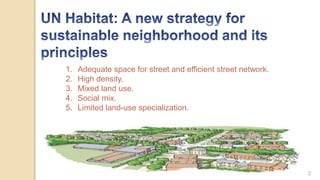
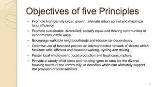
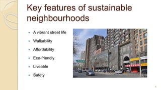
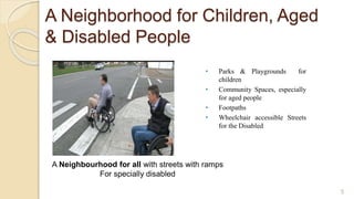
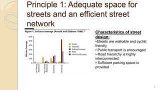
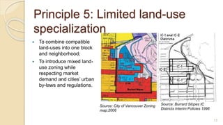
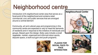
UN Habitat: A new strategy for sustainable neighborhood and its principles.
Key features of sustainable neighbourhoods.
A Neighborhood for Children, Aged & Disabled People.
etc
This document discusses urban morphology and the determinants of urban form. It begins by defining key terms like form, urban form, and urban morphology. It then describes the two main types of urban form - organic and grid oriented. The main determinants that shape urban form are described as natural (e.g. topography, climate) and man-made (e.g. political, religious, economic). Specific examples of each determinant are provided with images to illustrate how the determinant influenced the urban form. The document also includes a glossary defining terms commonly used in urban design like urban block, public realm, grain, and density.
Land Use and Legibility- Urban Design TerminologyGrace Henry
Land Use and Legibility- two basic and yet important terms used in Urban design. The definition, history and examples are listed through the presentation.
This document provides an overview of the concept of a compact city presented by a group of students. It begins with listing the group members and structure of the presentation. It then discusses the origin of compact cities, defines what a compact city is, and outlines the compact city model. Key characteristics of compact cities are presented for both developed and developing countries. The document contrasts compact cities with urban sprawl and defines an eco-compact city model. It lists indicators to measure compact cities and discusses both positive and negative impacts. Finally, it provides examples of cities that depict the compact city model.
Affordable Housing, Slum Redevelopment In Cities of IndiaRavikant Joshi
This PPT delivered to Scholars of Indian School of Public Policy discusses status and issues associated with affordable housing, slum upgradation, slum redevelopment in cities of India
- The document discusses two historical neighborhood concepts - Radburn neighborhood model by Stein and Wright, and Clarence Perry's neighborhood unit concept. Both aimed to design self-contained neighborhoods with boundaries, green spaces, and pedestrian-focused streets, though they differed in maximum walking distances and treatment as overlapping vs separate units.
- Neighborhoods are considered the basic building block of cities in planning, with the goal of improving social and physical environments. However, increased mobility has challenged the social benefits of neighborhoods.
- Contemporary developments often prioritize financial goals over unified social and physical environments, though neighborhoods remain important for decentralized, community-focused planning.
Clarence Perry was an American urban planner from the early 20th century. He is considered a pioneer in neighborhood unit planning. The key aspects of Perry's neighborhood unit model include centering an elementary school in the middle, placing arterial streets along the perimeter, designing a hierarchy of internal streets, and restricting local shopping to the perimeter. The goal was to create self-contained neighborhoods that promoted community and protected residents, especially children, from traffic.
Ebenezer Howard proposed the garden city concept as a solution to problems in late 19th century cities. He envisioned self-sufficient towns of around 30,000 people, surrounded by greenbelts, that combined the benefits of town and country living without their drawbacks. Letchworth Garden City, built in 1903, was the first to implement Howard's ideas of concentric design and separation of housing, industry and agriculture. The garden city movement aimed to reform urban planning and integrate people more with nature.
The document discusses the concept of the neighborhood unit plan proposed by Clarence Perry in the 1920s. The key aspects of Perry's plan included:
1) Neighborhoods of a fixed size to support one elementary school
2) Boundaries defined by arterial streets to discourage through traffic
3) Open spaces like parks and playgrounds making up 10% of the area
4) Community facilities like schools and shops located near the center
5) An internal street network to facilitate circulation within the neighborhood
The document describes the evolution of human settlements from early nomadic hunter-gatherer societies to permanent agricultural communities and eventually urban settlements. Early humans lived as nomads but began settling near sources of food and water as they learned farming. River valleys were popular early sites as they provided fertile land and resources. Settlements grew into organized communities with social hierarchies, division of labor, and new building types like castles and temples. Advanced civilizations featured specialized occupations, trade networks, and dense urban areas with infrastructure and cultural institutions.
This document discusses the public realm in cities. It defines public realm as shared communal space like parks, plazas, pathways, and streets. Public spaces influence city form and function through daily community interactions. The aim of public realm is for individuals to experience place together as a community, either directly or indirectly participating in public life. Examples of public realm components discussed include streets, parks, plazas, and art in public spaces. Properties like imageability, accessibility, meaning, continuity, choice, and flexibility are important to planning and designing liveable public spaces.
The document summarizes Charles Correa's incremental housing project in CBD Belapur, India. It describes the project's low-cost housing typologies designed around communal courtyards. Housing was organized into clusters of 7-12 pairs of freestanding homes arranged around shared spaces. This allowed residents to independently modify their own homes over time. While many original structures have been replaced, the hierarchy of community spaces remains intact decades later. The project demonstrated high-density affordable housing built at a human scale with simple materials. However, maintaining common spaces and adapting to changing aspirations have presented challenges over time.
Clarence Perry was an early 20th century American planner who developed the concept of the neighborhood unit. The neighborhood unit aimed to design self-contained residential areas that promoted community and protected residents from industrial areas and traffic. Key elements included centering the neighborhood around an elementary school, placing arterial streets on the perimeter, and dedicating 10% of land to parks and open space. The ideal neighborhood unit size was 5,000-6,000 people and 160 acres to allow children to walk half a mile to school and residents to access local services. Neighborhood planning principles focused on size, boundaries, internal streets, land use mix, and locating community facilities to encourage social interaction.
The document discusses the city planning of Chandigarh, India. It describes how Le Corbusier revised the initial plan by Albert Mayer, dividing the city into sectors of about 1200 by 800 meters. Each sector was designed as an autonomous neighborhood with housing, schools, shops, and recreational spaces. The capital complex was shifted to a higher ground and designed according to Le Corbusier's philosophies. While the planning approach was praised for creating a well-organized city, it was also criticized for being too standardized and not reflecting Indian culture and ways of life. The document analyzes the planning concepts and provides an overview of the development of Chandigarh.
The document discusses elements of urban design that shape cities, including buildings, public spaces, streets, landscape, and their interrelationships. It also summarizes Kevin Lynch's book "The Image of the City", which examines how residents mentally map their city based on paths, edges, districts, nodes, and landmarks. Finally, it provides examples of these elements in Mysore, India, highlighting landmarks like the Ambavilas Palace, focal points like Chamaraja Circle, and the city's planned layout with vistas, public squares, and response of buildings to the street network.
To plan a city/region, we require base data on which information extrapolation & decisions may happen. Hence, Identify ‘data needed’, and Identify ‘needs of data’ collection
Inspection survey:
A) Direct :
Observe traffic count/ situation
Observe housing quality
Observe economic activity
Observe social parameters, etc.
B) Indirect:
Clubbing of directly observed ‘indicators’ to generate area’s possible ‘proxy’.
For e.g. housing condition + plot sizes + no. & types of vehicles + consumer goods = income range
. Personal interview/ Dialogue:
A questionnaire is designed beforehand at appropriate scale:
Nominal Scale : Yes or No
Ordinal Scale : Possible options or multiple choice questions
Interval Scale : Range/ intervals like age group or income group
Structured questions are precise and one-way
Semi-structure survey is a two-way information flow. It’s an informal dialogue in which the surveyor might receive new information from respondent/s. however, it depends on;
Behavioural factors of surveyor and respondents
Questions not to be ambiguous or long
Managing conversation and seeking pin-point answers
Judging responses without bias
Recording interview
Avoiding errors
Cross-checking with other respondents
Major land uses to be identified for analysing physical distribution and existing conditions:
Developed
Under-developed
Un-developed
Major uses marked on map are as per the defined regional/city level plans, like;
Urbanizable zone
Industrial zone
Transportation & Communication zone
roads, railways, MRTS, Seaports, Dockyards, Airports, Bus depots/ terminals, freight complexes, transmission and communication
Primary activity zone
Agriculture, poultry, rural settlements, brick kilns, extraction areas
Open area zone
Recreation zone, green buffer zone
Protected/ Eco-sensitive zone
Water bodies, forests, sanctuaries, coastal zone, wetlands, marshy zone
special area zone
Heritage & conservation zone, scenic value, tourism zone, defence area/ zone, border conflict zone
Data regarding demographic characteristics;
Population growth (natural, induced)
Population size (age-wise)
Population density
Population distribution
Gender ratio
Socio-Economic status
Religion
Marital status
Education ratio
School dropouts
Gender-wise enrolment in schools, colleges
Mortality rate (age-wise)
Birth rate
Health rate (in some surveys)
Sample types for doing household/ demographic surveys;
Simple Random sampling
Systematic sampling
Stratified sampling
Cluster sampling
Multistage sampling
There are nine steps involved in the development of a questionnaire:
Decide the information required.
Define the target respondents.
Choose the method(s) of reaching your target respondents.
Decide on question content.
Develop simple & clear wording of questions
Put the questions into a meaningful order and format.
Check the length of the questionnaire.
Pre-test the questionnaire
Develop the final survey form.
Placemaking involves designing public spaces to serve the people and bring communities together through mixed uses, successful streets, open spaces, appropriate urban scale, movement frameworks, and a sense of place. It is about making spaces that people gravitate towards and that capture the soul of a neighborhood by creating local identity and embracing the people, buildings, events, and nature in an area. The goal is to take back the public realm and create character and meaning to make a space a living place for the community.
It is an assignment on urban design basic factors, whereas a designer should keep in mind in urban designing.
Here I tried to describe factors by pointing as anyone could find a basic concept o urban design. Hope it'll be helpful.
Urban squares have historically served as important public gathering spaces, often located at crossroads of trade routes. They function to provide shelter from traffic and represent psychological parking areas within cities. Factors that influence squares include surrounding buildings, proportions, entrance angles and central features. Squares can take different forms such as closed spaces enclosed by uniform buildings, dominated squares oriented around a focal point, nuclear squares with a central monument, grouped squares that combine into a whole, and amorphous squares without coherent shape. Over time, squares may evolve as new structures are added or old ones changed or destroyed.
Radburn was a planned community developed in 1929 based on principles of separating pedestrian and vehicle traffic. It had 25,000 residents within 149 acres containing single family homes, row houses, and apartments arranged around a network of cul-de-sacs and footpaths connecting to interior parks and community spaces. The development pioneered concepts like the superblock and was an early example of integrating residential, commercial, and industrial areas with open spaces.
The document describes the Tara Housing Group project in New Delhi, India. It was designed to provide affordable housing for middle-class families in a suburb of New Delhi. The design arranged single-family flats into united blocks around a central garden. This preserved privacy while providing access to shared open space. Each unit had an open terrace and maximized natural light and ventilation. While successful for its time, the design faces challenges today in accommodating increased living standards and development regulations around services, density, parking, and unit sizes. However, the social aspects of community space, interaction, and comfort remain relevant lessons for contemporary housing.
The document provides details for designing the Greater Noida District Centre, including its aims, major aspects of study, services and facilities, landscape components, job distribution to groups, and site analysis. Key points include preparing an urban form and design by integrating various disciplines. The district centre will include components like retail shopping, commercial offices, service centers, cultural complex, hotel, and landscaping. Site analysis is conducted and the allotted site is near Software Technology Park with many amenities.
The Yamuna Apartments housing complex in India was designed for lower-middle income residents and incorporates traditional Indian village design elements. The 200-unit development is arranged around pedestrian walkways called "galis" that converge on a central square, allowing residents to interact. Each unit overlooks the galis and includes a living room with balcony, private bedrooms, kitchen, and bathroom around a central light well. Landscaping, community spaces, and limiting vehicular access to the perimeter create a lively social environment emulating a village.
Architecture and urban design are public art forms that people experience through their daily activities in cities. While other art forms can be avoided, people cannot choose to avoid experiencing the built environment as they move through urban spaces. Aesthetic preferences in environments are influenced by both natural and learned social and cultural factors, and Jack Nasar identified five attributes of liked environments: naturalness, upkeep, openness, historical significance/content, and order. As people experience cities through movement, Gordon Cullen's concept of "serial vision" describes how urban design can create a series of revelations and contrasts that engage observers as their viewpoint changes.
The document discusses the principles and concepts of neighborhood planning. It explains that neighborhood planning aims to create small residential units of 2,000-5,000 people to foster a sense of community. Key aspects of neighborhood planning include limiting the size to a walkable area, using boundary roads, incorporating green spaces, designing internal streets for safety, providing a mix of housing, locating shops and community centers in central areas, and including facilities like schools and parks within 1 km to encourage social life. The principles of neighborhood planning aim to balance residential development with community spaces and recreation to recreate the lost neighborhood relationships of modern cities.
The document summarizes a master plan for a new township development near Indore, India with the following key points:
- The plan was developed for a 220 acre site intended to house an initial population of 40,000 people. The master plan divided the site into sectors with a central commercial and institutional spine and mixed land uses.
- Housing was provided for a range of income groups, with lower income housing located centrally and higher income housing along perimeter roads. Basic infrastructure like roads, water, sewage was provided to each housing plot.
- The envisioned built form took cues from traditional local architecture, with low-rise, high density development and continuity of built edges to encourage community interaction while providing privacy
A Report on Urban Redevelopment which covers Introduction, Indicators of Redevelopment(Construction, Rehabilitation & Relocation), Local Study(Bangladesh), International Study of Redevelopment, Preservation aspect, and most important part of Redevelopment i.e. Methodology.
L’urbanisme désigne l'ensemble des sciences, des techniques et des arts relatifs à l'organisation et à l'aménagement des espaces urbains, en vue d'assurer le bien-être de l'homme et d'améliorer les rapports sociaux en préservant l'environnement. Les professionnels qui exercent ce métier sont des urbanistes.
The document provides information about the Histon & Impington Neighbourhood Plan, including:
- The importance of having a Neighbourhood Plan for securing funding and controlling development.
- The territory covered by the plan, which excludes some areas near Cambridge.
- An overview of the community's characteristics including amenities, employment, and housing.
- Issues identified through community surveys such as maintaining village character, healthcare, housing, and transport.
- A vision statement outlining goals for the community's future development.
- Six priority areas and four guiding principles to achieve the vision.
- Specific policies addressing each priority area, such as design standards, protecting employment sites, and open space
This document provides a summary of the National Housing Policy of Bangladesh. It outlines the objectives of making adequate housing accessible to all socioeconomic groups. The key proposed strategies include prioritizing housing in development plans, promoting affordable housing solutions like self-help and personal savings, and discouraging unauthorized settlements. The essential elements of the policy cover topics like land, infrastructure, finance, building materials, legal frameworks, and addressing needs of vulnerable groups. The roles of various stakeholders like government agencies and private sector are also defined.
KKKH4284 URBAN PLANNING OF SUSTAINABLE DEVELOPMENT
TASK 5 : LOCAL AGENDA
LECTURERS :
PROF. IR. DR. RIZA ATIQ ABDULLAH O.K. RAHMAT
DR NAZRI BORHAN
DR NORLIZA MOHD AKHIR
This document outlines five principles of sustainable neighbourhood planning proposed by UN-Habitat:
1. Adequate street networks occupying at least 30% of land with 18km of streets per square km.
2. High density of at least 15,000 people per square km.
3. Mixed land use with at least 40% of floor space for economic use.
4. Social mix of housing for different incomes.
5. Limited specialization with single function blocks under 10% of neighbourhoods.
The principles aim to promote compact, integrated and connected cities by encouraging walkability, mixed uses, and efficient land and resource use over urban sprawl.
Smart Growth (A21): The wolf at your front door (part 2)Patti Gettinger
Threats to private property rights from smart growth policies (aka sustainable development, livable communities, Agenda 21), including eminent domain and restrictions to mobility are based on failed socialist models.
Neighbourhood Plan priorities and enabling actions ver 0.1hisimp
The document outlines a neighbourhood plan with the following priorities:
1. To encourage growth of local businesses and ensure social infrastructure adapts to community needs.
2. To ensure sufficient sustainable housing, including affordable options, that meet changing needs.
3. To develop sustainable transportation and make the villages safe, supportive places for all.
The plan then provides more details on proposed actions to address each priority, such as promoting local retailers, supporting housing diversity and ownership models, and expanding active transportation infrastructure.
The document outlines the priorities and plans for a neighbourhood plan, including:
- Encouraging local businesses and ensuring sufficient housing that meets community needs
- Developing social infrastructure and promoting activities for all ages
- Creating a network of sustainable transportation including footpaths, cycleways, and public transit
- Maintaining a safe and secure community through volunteer programs and access to services
This document summarizes three case studies related to housing policy and development:
1) A slum upgrading project in Bangladesh that rebuilt 13 homes using local materials with funding from international donors.
2) A conceptual project in Singapore that combines senior housing with vertical urban farming to provide housing and employment.
3) An incremental, mixed-income housing project in India called Aranya that uses local materials and self-construction techniques.
New Urbanism is an urban planning and design movement that arose in the late 1980s in response to the spread of suburban sprawl. It advocates compact, walkable, mixed-use communities designed with pedestrians in mind to reduce dependence on cars. The key principles of New Urbanism include walkability, connectivity, mixed-use and diversity, mixed housing types, emphasis on public spaces and human-scale design, traditional neighborhood structure, increased density, green transportation options, and sustainability. The goals are to create healthier, more socially diverse communities with less traffic and a smaller environmental impact.
This document discusses the added value of using evidence-based guidance in urban design practices to promote heart health. It presents an initiative led by the National Heart Foundation in collaboration with government departments and private partners to develop tools and resources to support healthy built environments. The initiative included consultation with stakeholders, evidence reviews, case studies of best practices, and the development of a Healthy Active by Design tool with features such as mixed-use development, transportation networks, public spaces, and housing diversity. The tool and additional resources are intended to provide guidance for planners, developers and others on creating communities that encourage physical activity and reduce heart disease risk factors.
The document outlines 10 principles for improving cities through public spaces as identified by the Project for Public Spaces, including improving streets for pedestrians and cyclists, creating multi-use parks and squares, building local economies through markets, and restructuring government to better support public spaces through citizen participation and bottom-up policymaking.
Urban sprawl is a common phenomenon throughout Europe that has major environmental, social, and economic impacts. It undermines efforts to combat climate change by increasing energy and land consumption. While European cities were traditionally more compact, today various factors are driving urban sprawl, including improved transportation links, personal mobility, and individual housing preferences. Addressing sprawl requires compact urban development with mixed land uses, accessible public transportation, and coordinated urban planning policies between cities and rural areas. The European Union is promoting more sustainable urban development through initiatives that encourage compact cities, public transportation, and smart governance approaches.
The document outlines a proposed EcoInnovation District plan for Uptown/West Oakland in Pittsburgh. The plan was created through community engagement to improve equitable growth, economic development, and sustainability in the area. Key strategies in the plan include preserving affordable housing, encouraging mixed-use and green development, protecting existing residents and businesses, and providing more transportation choices such as improved bus service.
The document summarizes Ontario's updated 2012 Transit-Supportive Guidelines. The guidelines were first published in 1992 and provide strategies to assist municipalities in creating transit-supportive land use and increasing ridership. The 2012 update expands on land use and introduces new chapters on improving transit services. It aims to support provincial growth plans and priorities by encouraging compact, mixed-use development near transit.
This document outlines the principles of smart growth development, which aims to curb urban sprawl and environmental degradation. The 10 principles are to mix land uses, take advantage of compact building design, create a range of housing and walkable neighborhoods, foster distinctive communities with a strong sense of place, preserve open space and environmental areas, strengthen existing communities, provide transportation choices, and make development predictable, fair, and encourage community collaboration. Examples are given for how principles like mixed land uses, compact design, and range of housing can achieve these goals.
Clarence Perry was an American urban planner who promoted the concept of the neighbourhood unit in the 1920s. He advocated for self-contained residential communities centered around a school, with arterial roads along the perimeter and a hierarchy of internal streets. Neighbourhood units were intended to be walkable, with amenities like parks, playgrounds, and shopping areas accessible within a quarter mile. The goal was to improve quality of life by fostering social interaction and providing safe spaces separated from traffic and industrial areas. Perry's model influenced planning in U.S. cities in the early 20th century.
Presentation on Rural Proofing made at the WHO webinar held on 15 July 2021. Presentation by Ana Moreno Monroy, OECD Regional Development and Multi-level Governance Division.
More information: https://www.oecd.org/regional/rural-development/rural-service-delivery.htm
Urban renewal is a comprehensive strategy aimed at dealing with urban decline and decay through policies and actions that improve economic, physical, social, and environmental conditions in problematic urban areas. It involves rearranging land use, ownership, and functions through redevelopment, rehabilitation, conservation, and infrastructure improvements. Urban renewal is needed in old, congested urban areas where dilapidated buildings, lack of facilities, and obsolete land uses have reduced the potential and livability of cities. In India, rapid urbanization has overwhelmed aging infrastructure, leading to decay in city cores, making urban renewal crucial to revive cities with long histories.
The document classifies and describes different types of urban roads: expressways for heavy, fast traffic between major locations; arterial streets for heavy intra-city traffic along expressways; sub-arterial streets with less traffic than arterials; collector streets that connect local streets to arterials; and local streets for access to properties. It also discusses common urban road patterns like rectangular, radial, grid, and hexagonal patterns. Finally, it compares key aspects of roadways and railways, noting that roads have lower construction and maintenance costs and more flexibility than railways but also higher accident rates and lower load capacity.
Demographic characters of bhilwara city Satyam Rai
Bhilwara city is located in the Marwar region of Rajasthan. According to the 2011 Census, the population of Bhilwara city is 359,483, with 52% male and 48% female. The literacy rate is 71.5% overall, with 77.76% for males and 64.7% for females. The birth rate is 22.2 per 1000 population, death rate is 5.6 per 1000, and natural growth rate is 14.8 per 1000. Major cultural festivals in Bhilwara include Sheetla Saptami celebrated in honor of Sheetala Mata, goddess of children, and Rang Teras celebrated with colors like Holi.
Rational choice theory proposes that people make rational decisions based on weighing costs and benefits to maximize personal utility. It is used to explain social change as resulting from individuals making utility-maximizing choices. Critics argue people do not always make decisions through strict cost-benefit analysis. The theory assumes humans are goal-oriented and make rational calculations to optimize pleasure or profit when choosing between alternatives. However, it cannot fully explain phenomena like altruism that are not self-interested.
Comprehensive mobility plan jaipur
National Urban Transport Policy
Mobility issues – snapshot of today
Transport demand for the future
Evaluating and implementation of cmp
Buddhist monasticism – study of 3 regionsSatyam Rai
Buddhist Monks – from the 6th Century BC
Buddhism - Its Beginning
Monastery Life
Tibetan Monks – Buddhist Monasticism
South East Asian Monks – Buddhist Monasticism
Certain religious beliefs
Development induced displacement often forcibly relocates millions of people worldwide each year for large-scale projects like dams, airports, and infrastructure. This causes profound social and economic disruption as communities are broken up and livelihoods lost. A case study examines the Sardar Sarovar Dam project in India, which will displace over 100,000 people from 245 villages. Another case study looks at the Cochin International Airport in Kerala, which acquired over 1,200 acres of land and displaced 872 households, mainly from scheduled castes. The displaced communities suffered negative impacts like loss of land, livelihoods, and income, as well as food insecurity and homelessness.
Rationalism holds that reason, rather than sensory experience, is the primary source of knowledge. Key rationalist philosophers include Descartes, who believed that clear and distinct ideas derived through reason are certain, while sensory experiences could be deceiving. He argued that we can understand concepts like polygons through reasoning rather than just senses. Later rationalists like Pythagoras, Plato, and Aristotle emphasized using logic and reasoning to derive truths. In architecture, rationalism sees the field as a science that can be understood through rational principles, as first proposed by Vitruvius. It was an influential movement in early 20th century Italy and again in the late 1960s.
The document outlines the key components of a regional transport plan, including what regional transport planning entails, the background and purpose of guidelines for these plans, and some of the strategies and processes involved. It discusses how regional transport plans are developed by metropolitan planning organizations every 5 years to identify transportation needs and priorities over a 30-year period. It also briefly describes some elements that are often included in these plans like alternative strategies, financial plans, and performance measures.
This document provides a summary of the Comprehensive Mobility Plan for the Vellore Local Planning Area from 2013-2033. It outlines the objectives of developing a sustainable transportation system to satisfy mobility needs. The plan proposes improvements to public transportation including Bus Rapid Transit and Multi-Modal Rail systems. It also recommends expanding the road network hierarchy and developing a 150km network of footpaths and cycle tracks to improve non-motorized transportation. The overall vision is to shift 40% of trips from personal vehicles to public transit and provide an accessible, integrated transportation system to serve the population of Vellore.
Chapter wise All Notes of First year Basic Civil Engineering.pptxDenish Jangid
Chapter wise All Notes of First year Basic Civil Engineering
Syllabus
Chapter-1
Introduction to objective, scope and outcome the subject
Chapter 2
Introduction: Scope and Specialization of Civil Engineering, Role of civil Engineer in Society, Impact of infrastructural development on economy of country.
Chapter 3
Surveying: Object Principles & Types of Surveying; Site Plans, Plans & Maps; Scales & Unit of different Measurements.
Linear Measurements: Instruments used. Linear Measurement by Tape, Ranging out Survey Lines and overcoming Obstructions; Measurements on sloping ground; Tape corrections, conventional symbols. Angular Measurements: Instruments used; Introduction to Compass Surveying, Bearings and Longitude & Latitude of a Line, Introduction to total station.
Levelling: Instrument used Object of levelling, Methods of levelling in brief, and Contour maps.
Chapter 4
Buildings: Selection of site for Buildings, Layout of Building Plan, Types of buildings, Plinth area, carpet area, floor space index, Introduction to building byelaws, concept of sun light & ventilation. Components of Buildings & their functions, Basic concept of R.C.C., Introduction to types of foundation
Chapter 5
Transportation: Introduction to Transportation Engineering; Traffic and Road Safety: Types and Characteristics of Various Modes of Transportation; Various Road Traffic Signs, Causes of Accidents and Road Safety Measures.
Chapter 6
Environmental Engineering: Environmental Pollution, Environmental Acts and Regulations, Functional Concepts of Ecology, Basics of Species, Biodiversity, Ecosystem, Hydrological Cycle; Chemical Cycles: Carbon, Nitrogen & Phosphorus; Energy Flow in Ecosystems.
Water Pollution: Water Quality standards, Introduction to Treatment & Disposal of Waste Water. Reuse and Saving of Water, Rain Water Harvesting. Solid Waste Management: Classification of Solid Waste, Collection, Transportation and Disposal of Solid. Recycling of Solid Waste: Energy Recovery, Sanitary Landfill, On-Site Sanitation. Air & Noise Pollution: Primary and Secondary air pollutants, Harmful effects of Air Pollution, Control of Air Pollution. . Noise Pollution Harmful Effects of noise pollution, control of noise pollution, Global warming & Climate Change, Ozone depletion, Greenhouse effect
Text Books:
1. Palancharmy, Basic Civil Engineering, McGraw Hill publishers.
2. Satheesh Gopi, Basic Civil Engineering, Pearson Publishers.
3. Ketki Rangwala Dalal, Essentials of Civil Engineering, Charotar Publishing House.
4. BCP, Surveying volume 1
Main Java[All of the Base Concepts}.docxadhitya5119
This is part 1 of my Java Learning Journey. This Contains Custom methods, classes, constructors, packages, multithreading , try- catch block, finally block and more.
How to Setup Warehouse & Location in Odoo 17 InventoryCeline George
In this slide, we'll explore how to set up warehouses and locations in Odoo 17 Inventory. This will help us manage our stock effectively, track inventory levels, and streamline warehouse operations.
This document provides an overview of wound healing, its functions, stages, mechanisms, factors affecting it, and complications.
A wound is a break in the integrity of the skin or tissues, which may be associated with disruption of the structure and function.
Healing is the body’s response to injury in an attempt to restore normal structure and functions.
Healing can occur in two ways: Regeneration and Repair
There are 4 phases of wound healing: hemostasis, inflammation, proliferation, and remodeling. This document also describes the mechanism of wound healing. Factors that affect healing include infection, uncontrolled diabetes, poor nutrition, age, anemia, the presence of foreign bodies, etc.
Complications of wound healing like infection, hyperpigmentation of scar, contractures, and keloid formation.
Gender and Mental Health - Counselling and Family Therapy Applications and In...PsychoTech Services
A proprietary approach developed by bringing together the best of learning theories from Psychology, design principles from the world of visualization, and pedagogical methods from over a decade of training experience, that enables you to: Learn better, faster!
it describes the bony anatomy including the femoral head , acetabulum, labrum . also discusses the capsule , ligaments . muscle that act on the hip joint and the range of motion are outlined. factors affecting hip joint stability and weight transmission through the joint are summarized.
How to Make a Field Mandatory in Odoo 17Celine George
In Odoo, making a field required can be done through both Python code and XML views. When you set the required attribute to True in Python code, it makes the field required across all views where it's used. Conversely, when you set the required attribute in XML views, it makes the field required only in the context of that particular view.
2. 1. Adequate space for street and efficient street network.
2. High density.
3. Mixed land use.
4. Social mix.
5. Limited land-use specialization.
2
3. Objectives of five Principles
Promote high density urban growth, alleviate urban sprawl and maximize
land efficiency.
Promote sustainable, diversified, socially equal and thriving communities in
economically viable ways.
Encourage walkable neighbourhoods and reduce car dependency.
Optimise use of land and provide an interconnected network of streets which
facilitate safe, efficient and pleasant walking, cycling and driving.
Foster local employment, local production and local consumption.
Provide a variety of lot sizes and housing types to cater for the diverse
housing needs of the community, at densities which can ultimately support
the provision of local services.
3
4. Key features of sustainable
neighbourhoods
A vibrant street life
Walkability
Affordability
Eco-friendly
Liveable
Safety
4
5. A Neighborhood for Children, Aged
& Disabled People
• Parks & Playgrounds for
children
• Community Spaces, especially
for aged people
• Footpaths
• Wheelchair accessible Streets
for the Disabled
A Neighbourhood for all with streets with ramps
For specially disabled
5
6. Principle 1: Adequate space for
streets and an efficient street
network
Characteristics of street
design:
•Streets are walkable and cyclist
friendly
• Public transport is encouraged
• Road hierarchy is highly
interconnected
• Sufficient parking space is
provided
6
7. Principle 2: High density
High density has economic, social and environmental benefits as
follows:
Efficient land use slows down urban sprawl because high density
neighbourhoods can accommodate more people per area.
Reduced public service costs.
Support for better community service.
Reduced car dependency and parking demand, and increased support for
public transport.
Provision of social equity.
Support for better public open space.
Increased energy efficiency and decreased pollution.
7
8. Principle 3: Mixed land-use
The purpose of mixed land-use is
To create local jobs,
promote the local economy,
reduce car dependency,
encourage pedestrian and cyclist traffic,
reduce landscape fragmentation,
provide closer public services and
support mixed communities.
8
9. Principle 4: Social mix
Social mix is a socio-spatial concept, with the following objectives:
To promote more social interaction and social cohesion across groups;
To generate job opportunities;
To attract additional services to the neighborhood;
To sustain renewal/regeneration initiatives.
9
10. Cont…
Possible policies include:
Promoting social mix by mixing tenures and developing sales programmes
within public estates;
Achieving social mix through allocation policies and the spatial distribution of
poor households.;
Investing in and improving public housing;
Achieving social mix by urban and housing design;
Promoting multi-level employment within the community;
Working with private developers to increase public housing supply;
Providing plots in different sizes and with different regulations, to increase
the diversity of housing options.
10
11. Principle 5: Limited land-use
specialization
To combine compatible
land-uses into one block
and neighborhood;
To introduce mixed land-
use zoning while
respecting market
demand and cities’ urban
by-laws and regulations.
Source: City of Vancouver Zoning
map,2006
Source: Burrard Slopes IC
Districts Interim Policies 1996
11
12. Introduction of A neighborhood center area that serves as a
focal point of the neighborhood and contains retail,
commercial, civic and public services that are arranged
around a central element
Community, art and cultural uses and programming in this
community centre are expected to vary to meet the demands
of residents and in response to the initiative of individuals and
groups. Based upon the design, likely uses include a small
vegetable market, organized and informal indoor sports,
daycare space, a work-out gym and youth programs.
PLACES FOR
SOCIAL FACE-TO-
FACE
INTERACTION
Neighborhood centre
12
13. Application of the Five
Principles
Fast growing cities
New urban settlements and urban extensions
Urban renewal and renaissance
Urban densification
13