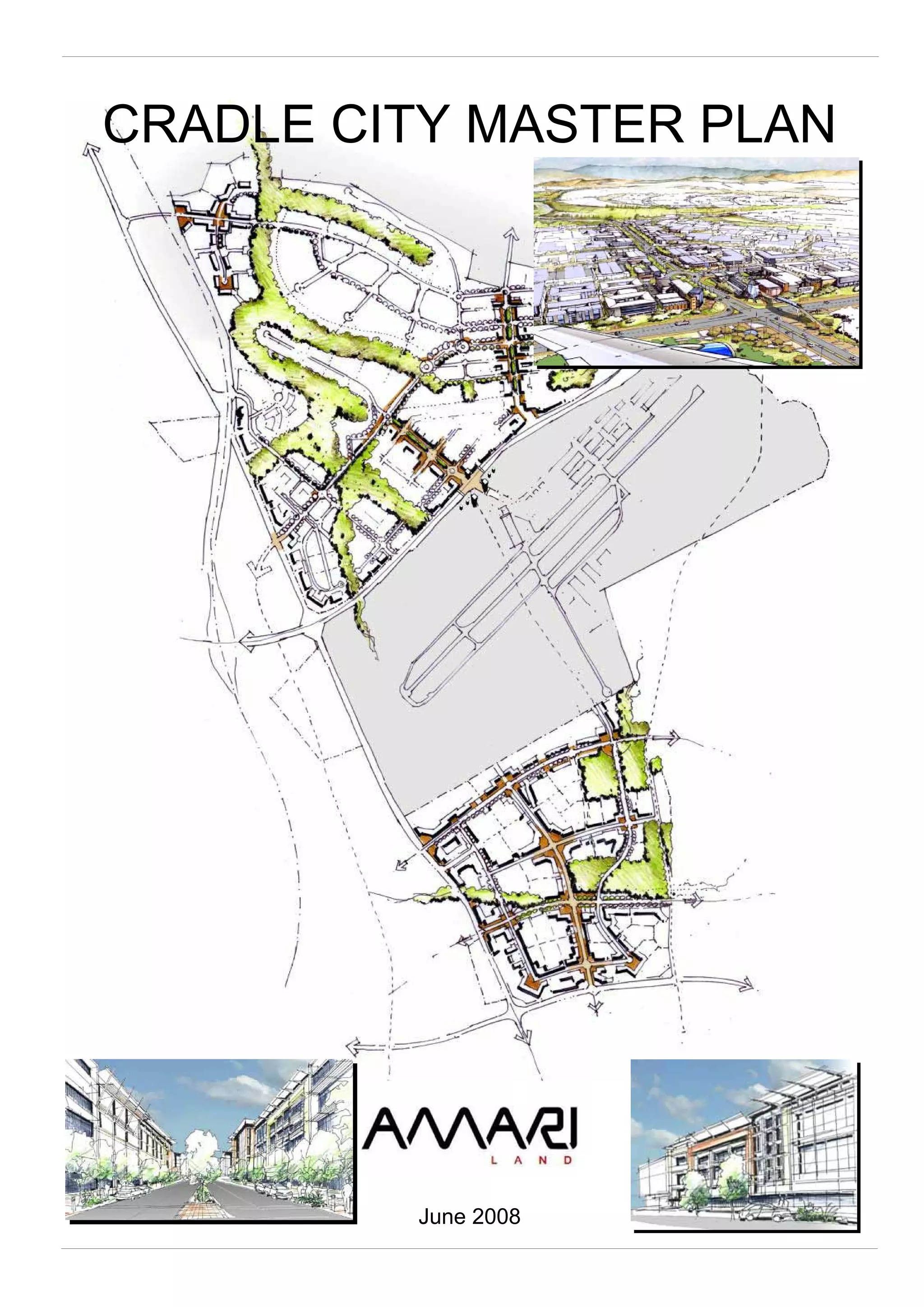
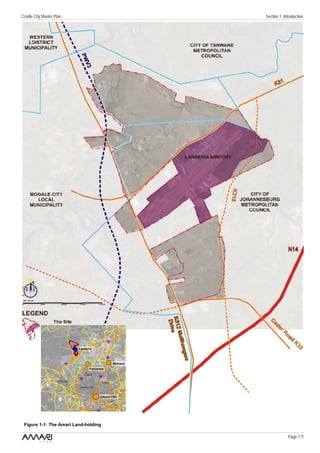
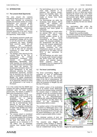
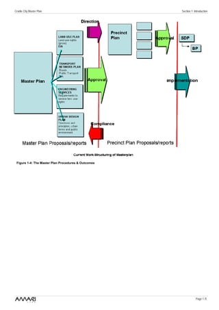
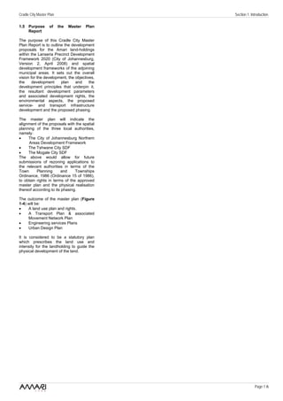
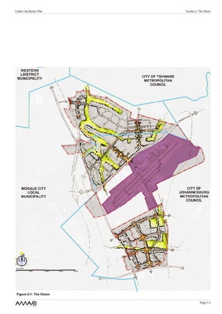
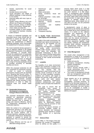
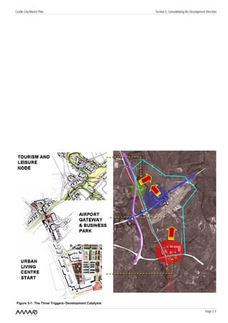
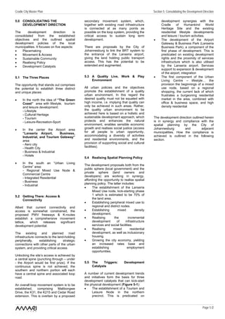
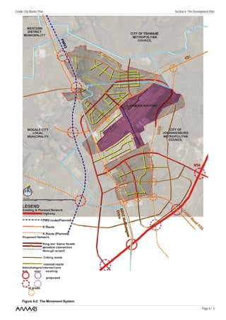
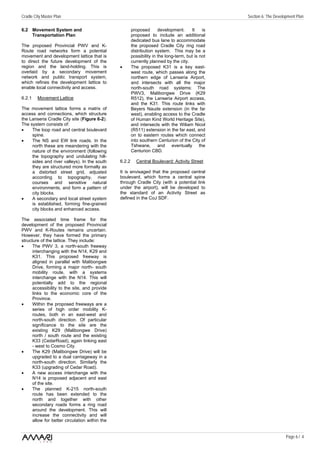
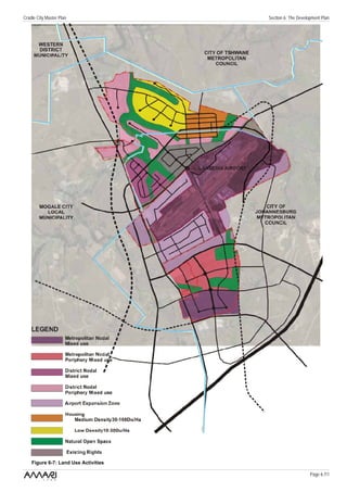
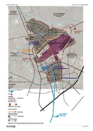
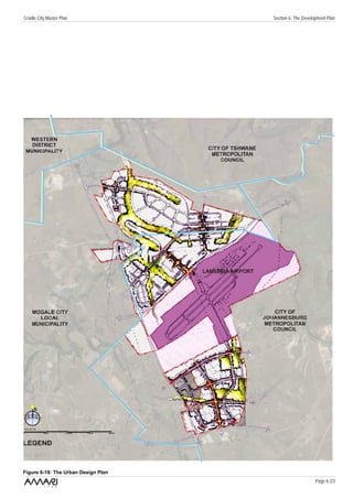
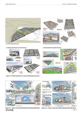
CRADLE CITY MASTER PLAN


         June 2008
CRADLE CITY MASTER PLAN
                          27 June 2008


                       Submitted to the
                 City of Johannesburg
Development Planning and Urban Management Department
         (Development Planning & Facilitation)


                         Prepared by the
                  Cradle City Professional Team:
               GAPP Architects & Urban Designers
               ASM Architects & Urban Designers
       Van Brakel Professional Planning & Property Services
      PDNA & Associates (transport & services infrastructure)
              RWP Consulting Electrical Engineers
                       SEF (environmental)


                               For
Cradle City Master Plan                                                              Contents

CONTENTS                                  6.3 Public Environment, Landscape &
                                              Natural Environment Plan
1.0 INTRODUCTION                          6.4 Land Use Activities, Community
1.1 The Lanseria Node Opportunity             Facilities and Housing
1.2 The AMARI Land-holding                6.5 Land Budget and Development
1.3   Building on the Gauteng Growth          Rights
      and Development Strategy and        6.6 Engineering services &
      Meeting City Region Strategy            Infrastructure Development Plan
      Objectives                          6.7 The Urban Design Plan
1.4 Unlocking the Opportunity
1.5   Purpose of the Master Plan Report   7.0 THE DEVELOPMENT PRINCILES
                                              & DESIGN GUIDELINES
2.0 THE VISION                            7.1 Environment
                                          7.2 Movement & Transportation
3.0 THE OBJECTIVES                        7.3 Engineering Services & Social
3.1 An Economically & Spatially Viable        Facilities
      Development                         7.4 Place-making Guidelines
3.2 A Sustainable Environment                 -     Built form & public spaces
3.3 An Integrated Movement Framework                design guidelines
3.4 Mixed Use, Mixed Density &                 -    Sustainable built environment
      Supporting Social Facilities                  guidelines
3.5 Sustainable Infrastructure                 -    Architectural & green building
      Development- Energy & Resource                principles
      Efficiency
3.6 A Quality Public Environment, Open    8.0 THE PRECINCT STRUCTURE,
      Space and Landscape                     PRECINCT PLANS AND PHASING
3.7 Urban Management                      8.1 The Precinct Structure
                                          8.2 Package of Plans Approach
4.0 ALIGNMENT WITH SPATIAL                8.3 Precinct Plan Requirements
      DEVELOPMENT POLICIES OF             8.4 Proposed Phasing
      LOCAL AUTHORITIES
4.1 City of Johannesburg                  9.0 CONCLUSION
4.2 Mogale City SDF
4.3   City of Tshwane SDF


5.0 CONSOLIDATING THE
      DEVELOPMENT DIRECTION
5.1 The Three Places
5.2 Getting There: Access &
      Connectivity
5.3 A Quality Live, Work & Play
      Environment
5.4 Realising Spatial Planning Policy
5.5 The Triggers: Development
      Catalysts


6.0 THE CRADLE CITY MASTER
      PLAN
6.1 The Overall Spatial Structure.
6.2 Movement Systems &
      Transportation Plan

                                                                                      Page i
Cradle City Master Plan                               Section 1: Introduction


                          Lanseria


                                            Midrand
                                Fourways


                                     Joburg CBD


 Figure 1-1: The Amari Land-holding

                                                                   Page 1 /1
Cradle City Master Plan                                                                                                   Section 1: Introduction

1.0 INTRODUCTION                                 •    The land-holdings are on the rural-          is primarily are used for agricultural
                                                      urban edge, adjacent to an                   purposes and rural residential. An
                                                      extensive and growing tourism,               exception to this is a 90Ha land portion
1.1 The Lanseria Node Opportunity                     leisure and hospitality region. This         adjoining the airport to the north, which
                                                      includes, in close proximity, the            has existing zoning rights for industrial
The     area     around     the    Lanseria           Cradle of Human Kind World                   and business rights. AMARI is presently
International Airport has for a number of             Heritage Site.                               obtaining approvals and undertaking
years been identified by prospective             •    The land-holdings are within the             township establishment procedures to
property and business owners as a major               developing Hans Strijdom (R512)              enable it to develop the land and release
development and economic growth                       corridor     with    industrial   and        it to the market.
opportunity. The realisation of this                  residential development interest.
opportunity has been hindered in the past             This indicates that existing growth is       The land-holding falls within the
due      to     supporting    infrastructure          happening and future growth is               administrative jurisdiction of two local
development       constraints    and     the          anticipated.                                 municipalities:
fractured ownership of the land. Various         •    The land-holdings are nested within          •     The City of Johannesburg
recent initiatives have begun to unlock               the planned PWV- and K routes                •     Mogale City Local Municipality
this opportunity. These include:                      provincial road network. This                The northern border of the land-holding is
                                                      provides excellent access to the             in close proximity of the City of Tshwane’s
•     The Gauteng province’s growth and               land-holdings        and        overall      municipal boundary.
      development strategy and its drive              connectivity to the existing urban
      to turn the province into a globally            system. The proposed realisation of
      competitive city region. Enabling               the developments will also bring
      faster economic growth and job                  forward the physical establishment
      creation        are       imperatives.          of the provincial road system.
      Undoubtedly the Lanseria node has               Existing investment into road
      a role to play and an important                 infrastructure around the airport is
      contribution to make within this                estimated at R 120 million, and the
      policy dynamic.                                 R512 is also earmarked for
•     The strategic urban planning for the            upgrading.
      Lanseria Node by the City of               •    The land-holdings are within reach
      Johannesburg,        the      Lanseria          of new key public transport systems
      Development       Framework      2020           (the SPTN routes with their BRT
      (Version       2.0,     Johannesburg            systems and potential Gautrain
      Metropolitan     Municipality,   April,         feeder     systems),     which     are
      2008) identifies the Lanseria airport           envisaged to form an integral part of
      as a major business and commercial              the future development.
      node within the precinct. The
      development framework directs the
      future development of the area,            1.2 The Amari Land-holding
      effectively unlocking the inherent
      development opportunity, provided          The Amari Land-holding (Figure 1-1)
      that its directives are met and that       comprises an area of approximately
      policy is complied with. Similarly the     900Ha located around the Lanseria
      Mogale City spatial development            International Airport in the north-western
      framework identifies Lanseria airport      areas of the City of Johannesburg. The
      as an opportunity, allowing for mixed      northern part of the landholding also falls
      use development in the vicinity of         within the jurisdiction of Mogale City and
      the airport.                               the City of Tshwane.

It is in this context that the AMARI land        The northern portion of the landholding
company has made a significant property          has as its western border Malibongwe
investment within the wider Lanseria             Drive and the southern border comprises
precinct area. The reasons, in addition to       the Lanseria airport. It stretches north-
latest policy developments, include:             eastward, across the municipal boundary
•      The strategic location of the land-       of the City of Johannesburg into the
       holding gives it the potential to be      foothills  of   the    Rhenosterkoppies,
       developed      into      a     regional   bordering with residential lifestyle estates
       development      node.      This,    as   such as Monahan and Blair Atholl. This
       highlighted above, is recognised by       portion    of    the     landholding       is
       the City of Johannesburg’s future         approximately 500Ha in extent.
       planning for the area. This will
       require the integrated development        The southern portion of the land-holding
       of higher order facilities and central    is bordered by Malibongwe Drive in the
       business district elements, with          west, the extension of Cedar Road in the
       supporting               infrastructure   south, the proposed K215 in the east, and
       development.                              the airport landholding in the north. This
•      The Lanseria airport is considered        portion is approximately 400Ha in extent.
       as an established regional anchor
       and growing catalyst that is bringing     Two individual portions of land are
       increasing development energy to          located to the west and east of the airport.
       the area. The airport is to be
       upgraded via an investment of R           The acquired area (Figure 1-2)
       100 million, and its passenger            comprises mainly farmland of relatively
       volumes have doubled every 9              small portions and smallholdings which
       years.                                    have an “undetermined” zoning. The land         Figure 1-2: Land Acquisition


                                                                                                                                       Page 1 /2
Cradle City Master Plan             Section 1: Introduction


  Figure 1-3: City Region Context

                                                 Page 1 /3
Cradle City Master Plan                                                                                                      Section 1: Introduction

1.3 Building on the Gauteng Growth             iii.   Tourism.                                      the Lanseria node has the potential to be
    and Development Strategy and               iv.    Agriculture (agri-processing and bio-         expanded and consolidated into a
    Meeting City Region Strategy                      tech).                                        regional node. The regional connections
    Objectives                                 v.     Manufacturing       (steel    related         and its accessibility support this. Its
                                                      industries, automotive parts and              development       will   consolidate    the
In the Newsletter of the Gauteng                      components, beer and malt).                   Malibongwe drive development corridor,
Provincial Government, Gauteng News            vi.    Infrastructure     expansion      and         and bring new development into the sub-
(April / May 2008), the Gauteng                       investment.                                   region, complementing the existing
government states that building Gauteng                                                             residential development and commercial
into a globally competitive city region is       Within the provincial GDS, the city region         activity associated with Lanseria airport.
the overarching response to the                  initiative is a specific mechanism, which
challenges of poverty, unemployment and          includes, amongst other salient features,
underdevelopment, which face the                 the following objectives:                          1.4 Unlocking the Opportunity
province.                                        •      To enable significant agglomeration
                                                         and size.                                  To unlock the major opportunity that is
In a briefing to journalists, Premier            •      To establish high levels of economic        represented by the AMARI land-holding,
Shilowa states that “the provincial                      linkages      including     business       the following four principles have been
government will continue to invest money                 connectivity      and      economic        identified and adopted:
for the creation of strategic economic                   transactions.
infrastructure following the success with        •      To      build   significant  strategic      i.    Establish partnerships with the three
projects under Blue IQ”. This will be                    networks between the state-                      local authorities: The City of
driven by the establishment of an                        business-finance and voluntary                   Johannesburg, the City of Tshwane
investment vehicle called the Gauteng                    sectors.                                         and Mogale City local municipality.
Fund, which is to attract capital from the       •      To achieve a balance between
private     sector     and      state-owned              social and economic progress,             ii.    Establish      an     environmentally
enterprises, in addition to the R500 million             growth and redistribution.                       responsible and sustainable plan in
provincial seed funding already com-             •      To ensure appropriate socio-                      order to utilise resources in the most
mitted. The latter is to finance projects                economic        development      and             efficient manner, and comply with
such as the Gauteng Link (G-Link), the                   activities in conjunction with local             relevant environmental legislation.
Amakhosi       Stadium       precinct,   the             government.                                      This includes obtaining relevant EIA
Kopanong precinct, the Gauteng Freeway                                                                    authorisation and compliance.
Improvement Scheme, public hospitals,            In order to achieve a sustainable city
energy-generation projects and urban             region a spatial logic is needed to guide         iii.   Establish a plan that demonstrates
regeneration.                                    balanced development (Figure 1-3). The                   and places “inclusionary housing”
                                                 Gauteng urban system has developed as                    within it, which includes a range of
The focuses of the province’s efforts are        a particular pattern of nodes and                        housing     and     possibly    tenure
on:                                              corridors. Johannesburg has become a                     options. This in support of
•     Road infrastructure maintenance.           core node in the north-south development                 government’s       “Breaking      New
•     The establishment of a one-stop            corridor (PTA/JHB/Vereeniging) and in                    Ground” programme to build
     service and business portal to              the east-west development corridor                       spatially and socially integrated and
     support business in Gauteng.                (mining belt, from Krugersdorp to                        sustainable human settlements and
•     A number of programmes to build            Germiston). Over time, as the urban                      communities.
     spatially and socially integrated and       system expanded and development
     sustainable human settlements and           needs and activities within these centres         iv.    Establish a plan that supports and
     communities.                                intensified, a ring of nodes has developed               enhances infrastructure develop-
•     The fast-tracking of urban renewal         in concentric circles around them. The                   ment       in    partnership       with
     and mixed-income and mixed tenure           first ring, district (tertiary) nodes, supports          government. This is to enable co-
     settlements to enable the socio-            these centres, without taking over their                 ordinated and phased development
     economic          integration       of      function. As the centres matured with                    to the required standards, and in
     communities.                                more intense activities and the urban area               line with the negotiated allocation of
•     Establishing alternative, innovative       consolidated around them, and began to                   rights, and in support of overall bulk-
     health financing and service-delivery       expand further, a second ring of nodes                   infrastructure development of the
     options for health services.                was established. These are typically                     sub-region.
•     The provision of quality education,        regional nodes (secondary nodes), which
     especially to the poor.                     have similar functions to the primary city
•     A major provincial offensive against       centre nodes, but serve the expanded
     crime through the Gauteng Safety            urban hinterland. Nodes within this band
     Strategy.                                   include Midrand, Krugersorp, Kempton
•     The commitment to work together            Park, Germiston etc. Some of the latter
     with local government to build              are located on the main development
     Gauteng as a globally competitive           axes, and have contributed to the
     city region.                                establishment         of    the    development
•     The province’s commitment to the           corridors.
     success of the 2010 Fifa World Cup
     in South Africa.                            The Lanseria node falls within the band of
                                                 regional nodes, but has as yet not
 The proposed Cradle City development            advanced in development as the others. It
 contributes to the Gauteng Growth and           is located on the Malibongwe Drive
 Development Strategy (GDS). The latter          development axis, forming the northern
 focuses on the following six growth             “bookend”. In addition the R28 freeway
 sectors and clusters:                           forms a strong mobility link with
 i.    Smart industries (including ICT,          Krugersdorp and Centurion (south-west
       pharmaceuticals, etc.).                   Tshwane).       This       connectivity     is
ii.    Trade and services (including             complemented by additional main route
       finance and film).                        links with Midrand. It is in this context that


                                                                                                                                          Page 1 /4
Cradle City Master Plan                              Section 1: Introduction


 Figure 1-4: The Master Plan Procedures & Outcomes


                                                                 Page 1 /5
Cradle City Master Plan                         Section 1: Introduction

1.5 Purpose        of     the   Master   Plan
    Report

The purpose of this Cradle City Master
Plan Report is to outline the development
proposals for the Amari land-holdings
within the Lanseria Precinct Development
Framework 2020 (City of Johannesburg,
Version 2, April 2008) and spatial
development frameworks of the adjoining
municipal areas. It sets out the overall
vision for the development, the objectives,
the     development     plan    and     the
development principles that underpin it,
the resultant development parameters
and associated development rights, the
environmental aspects, the proposed
service- and transport infrastructure
development and the proposed phasing.

The master plan will indicate the
alignment of the proposals with the spatial
planning of the three local authorities,
namely:
•    The City of Johannesburg Northern
     Areas Development Framework
•    The Tshwane City SDF
•    The Mogale City SDF
The above would allow for future
submissions of rezoning applications to
the relevant authorities in terms of the
Town      Planning      and     Townships
Ordinance, 1986 (Ordinance 15 of 1986),
to obtain rights in terms of the approved
master plan and the physical realisation
thereof according to its phasing.

The outcome of the master plan (Figure
1-4) will be:
•    A land use plan and rights.
•    A Transport Plan & associated
     Movement Network Plan
•    Engineering services Plans
•    Urban Design Plan

It is considered to be a statutory plan
which prescribes the land use and
intensity for the landholding to guide the
physical development of the land.


                                                             Page 1 /6
Cradle City Master Plan   Section 2: The Vision


 Figure 2-1: The Vision

                                     Page 2 /1
Cradle City Master Plan                                                                             Section 2: The Vision & Section 3: The Objectives

2.0 THE VISION                                     sprawl) and establishes a quality living        3.0 THE OBJECTIVES
                                                   and working environment. This supports:
The vision of the Cradle City development          •    establishment of mixed use;                The Cradle City vision is based on a
(Figure       2-1)     represents     the          •    a built form that is adaptable over        series of development objectives, which
understanding of the initial development                time;                                      encompass the establishment of an
context (physical, economic and policy             •    making         connections           and   economically, socially, spatially and
wise), an assessment of the inherent                    establishing access;                       environmentally integrated mixed use and
opportunity represented in the AMARI               •    including a range of residential           mixed tenure development. The latter is
land-holding and the culmination of a                   opportunities;                             to be undertaken based on sustainable
series of aspirations. It shows what               •    inclusion of social, cultural, religious   principles across all sectors. The
AMARI would like to achieve, and what                   & entertainment facilities; and            established objectives fundamentally
can be achieved for the benefit of the             •    establishing a high quality public         direct the incremental development of the
wider urban region in general and the                   environment through place making           900Ha land-holding into a regional node.
Lanseria sub-region in specific.                        and landscape.                             It is in effect a new city which:
                                                                                                   •       Creates value for the land owner.
The Cradle City vision encompasses the             The realisation of the Cradle City vision is    •       Creates an economically viable and
establishment of a new city – bringing a           based on the understanding that this will               environmentally sustainable centre
new offering - within the Gauteng urban            require a partnership based approach,                   for the Lanseria sub-region.
system, structured around the Lanseria             given the diversity of role-players that a      •       Creates a quality live-work-play
airport node. This vision is to create an          development of this nature includes. It is              environment for all sectors of
urban development that is sustainable in           vital that a developmental partnership be               society.
economic, social, environmental and                created with all local authorities to effect
spatial / physical terms.                          the development and guide it over time. In
                                                   addition to this an appropriate urban           3.1 An Economically & Spatially
Economic sustainability encompasses the            management regime will have to be                   Viable Development
establishment of a development that is             established and maintained, which
viable and enables economic growth and             includes the participation of owners,           An economically viable development is
activities which:                                  residents, businesses and workforce, and        enabled through the establishment of an
•     meets market demand and creates              includes      the    good       governance      appropriate      level  of     development
      new market opportunities through             requirements of local government,               intensification, supported by applicable
      the establishment of a diversity of          directing the responsibilities of all role-     levels of densification and a diverse
      business and economic activities,            players and partnerships, and ensuring          activity mix. This enables it to capitalise
      and the targeting of niche markets;          that relevant management performances           on overall market development trends
•     attracts    capital   and    enables         and standards are met and maintained.           and positions it such that identified market
      investment;                                                                                  niches can be targeted and exploited.
•     creates long-term and sustained              The vision of Cradle City has yielded the
      employment opportunities; and                incremental development of a 900Ha              3.1.1    Intensification
•     increases land values & the                  land-holding into a regional node, with
      concomitant rates base of the city;          three distinct precincts:                       Urban development practice in South
                                                   •     The Business and Airport Precinct         Africa has, in response to urban growth
Social sustainability encompasses the              •     The Mixed Use Precinct                    pressures       (sprawl,      environmental
support of a diversity of users, from all          •     The Lifestyle, Leisure and Tourism        degradation, inequitable quality of life,
socio-economic      backgrounds,         and             Precinct                                  changing housing dynamics) moved
enables access to urban opportunity by             It is estimated that Cradle City will           toward the intensification – an increase in
even the marginalised in society. This is          potentially yield a mixed use regional          mixed land use and mixed residential
accompanied by the establishment of a              node with approximately 8 million m² of         densities - of new and existing urban
supporting       engineering          service      floor area and 180Ha of environmental           areas. This is considered an appropriate
infrastructure,   social   facilities    and       open space systems.                             way of making an urban environment
services, cultural and religious facilities,                                                       more     liveable    and     reducing   its
and entertainment, leisure and recreation.                                                         environmental impact.

Environmental                     sustainability                                                   This approach is supported in the Spatial
encompasses the integration of the                                                                 Development Frameworks of the affected
natural environment and associated                                                                 local authorities. The establishment of
heritage resources of the land-holding.                                                            strong viable nodes through the clustering
This includes the commitment to the                                                                and concentration of activities at
conservation       /     preservation      and                                                     appropriate     and   accessible    nodal
strengthening of existing ecological                                                               locations is overall policy. The nodes
processes, environmental systems and                                                               require to be well integrated with the
the enhancement of hydrological systems                                                            movement systems of the city and
and associated fauna and flora. It also                                                            support the surrounding sub-regions.
encompasses the commitment to the
reduction of the development’s ecological                                                          The above is reinforced by the drive to
footprint by the incorporation of                                                                  initiate    and      implement     corridor
environmentally sustainable forms of                                                               development. This establishes a clear
resources utilisation, such as alternative                                                         structure for movement and accessibility,
forms of energy, the adoption of a green                                                           supported by the establishment of a more
buildings approach, and more efficient                                                             compact urban form, which is directly
utilisation of water, electricity etc.                                                             linked to the strong high intensity, mixed
                                                                                                   use nodes and associated higher
Spatial and / or physical sustainability                                                           residential densities.
encompasses the establishment of an
urban development that completes                                                                   The aim is to ensure a more effective and
(complements) the urban system, is more                                                            efficient use of facilities, enabling people
compact in its urban form (avoiding urban                                                          to live closer to amenities and work


                                                                                                                                            Page 2 /2
Cradle City Master Plan                                                                           Section 2: The Vision & Section 3: The Objectives

opportunities. It also enables the               3.1.3   Diversification                         3.3 An Integrated Movement
management, maintenance, protection                                                                  Framework
and expansion of the significant public          For the optimal functioning of a
and private sector investment in services        development of this nature an appropriate       The movement framework of the
and infrastructure within a typical node.        diversity of land use activities should be      development determines its connectivity
This intensification approach is to be           established. This begins with those land        and accessibility, which in turn affects
driven by economic and environmental             uses that meet daily needs of residents         uses and activities, density, security and
sustainability to ensure that people are         and its workforce. Integrated with that         the impact of the development on
living in harmony with the environment.          should be a diverse range of secondary          adjoining     areas.     The      structural
                                                 activities, such as social support and          components of the movement framework
3.1.2    Densification                           public     facilities  (education,   health,    are the hierarchy of movement routes, the
                                                 religious), as well as public space and         associated intersections, access points
Hand in hand with intensification, is an         recreation areas. The business and retail       and crossings, cycle ways and the
appropriate level of overall densification.      activities to be promoted are informed by       pedestrian pathways (separate and / or
The number of people attracted to and            the urban and regional context of the           sidewalks), whist the individual activities
living within an urban environment,              development, and possibly a particular          and components comprise walking,
combined with their skills, knowledge and        activity or mix that gives the development      cycling, vehicular transport (commercial
disposable income, creates the potential         a focus, which reinforces the vision and        and private) and public transport.
economic market and creates the                  particular identity that is being sought,
required support threshold for amenities,        strengthens its position and role in the        A successful movement framework for the
services and facilities. In general terms,       wider urban context.                            development will:
the higher the population density in an                                                          •    provide a maximum choice for how
urban area, the better for the potential                                                              people will make their journeys
market threshold. The benefits of seeking        3.2 A Sustainable Environment                        (walking, cycling, motor-driven /
higher density levels include:                                                                        vehicular, and various modes of
•     Social:      Encouraging        positive   Conserving and enhancing the natural                 public transport);
      interaction and diversity, improving       environment, water systems and open             •    provides good access, taking into
      the viability of, and access to,           space systems form an integral part of the           account the kinds of movement that
      community services, and enabling           development of an urban environment.                 are generated within and for the
      more      and     better     integrated    This enables the integration and most                development; and
      residential development.                   effective utilisation of the urban area’s       •    establish clear connections to
•     Economic: Enhancing the economic           existing and future physical and natural             existing routes, local facilities and
      viability of development, and              resources. In general terms the open                 neighbouring nodes and activities.
      providing economies of scale with          space systems should support a range of
      regard      to   infrastructure    and     ecological,     social   and    institutional   The establishment of an efficient
      amenities                                  functions, which conserve and enhance           movement system is included in the
•     Transport: Supports public transport,      the urban environment’s natural heritage,       Spatial Development Frameworks of the
      reduces car travel and parking             and contributes to the establishment of a       affected local authorities. In general these
      demand, and makes underground /            sustainable living and urban environment        include:
      basement          parking         more     that supports human activities.                 •     The establishment of an Integrated
      economically viable.                                                                             Transport Plan.
•     Environmental: Increases energy            This approach forms an integral part of         •     The establishment of a road network
      efficiency,    decreases       resource    the Spatial Development Frameworks of                 hierarchy       and        associated
      consumption, potentially reduces           the affected local authorities. All have              management guidelines.
      pollution, preserves and helps fund        proposed Metropolitan Open Space                •     The establishment of appropriate
      the maintenance of public open             Systems with associated Environmental                 public transport infrastructure (bus,
      space and reduces urban sprawl.            Management Plans. The metropolitan                    rail and comb-taxi).
                                                 open space systems aim to establish an
To avoid the negative socio-economic             inter-connected and managed network of          The City of Johannesburg’s SDF states
and spatial impacts of over-densification,       open spaces that support interactions           that the “movement strategy is premised
the approach should be design-led,               between social, economic and ecological         on the provision and maintenance of a
underpinned by urban design principles           activities, sustaining and enhancing both       highly accessible movement system and
and design guidelines, concentrating on a        ecological     processes    and    human        network that supports a range of modes
sustainable and viable urban quality.            settlements (JMOSS).                            (road and rail, public and private) and
Urban market trends should be taken into                                                         activities at various levels, intensity and
account but must not necessarily dictate         In general, where identified areas have a       scale. It specifically endorses the
the outcome.                                     high conservation and / or recreation           promotion of the public transport as the
                                                 potential, the principle is that open space     means to increase accessibility of
This densification objective is also             and environmental considerations should         opportunities to all city users.”
supported in the Spatial Development             take precedence over development
Frameworks of the affected local                 considerations. This applies in particular
authorities. In general the active               to:                                             3.4 Mixed Use, Mixed Density and
densification of strategic locations within      •    Ecologically        sensitive      and         Supporting Social Facilities
the city area (in and around nodes, along             endangered areas.
mobility and transportation routes) is           •    Where the open space system                The       development    proposes       the
promoted to accommodate demand in                     requires to be linked to re-establish      establishment of a mixed use and mixed
close proximity to existing economic                  continuity.                                density development, with an appropriate
opportunities and infrastructure. This also      •    Where the restoration of the               level of supporting social facilities and
avoids increased urban sprawl and                     ecological balance is required.            services. The benefits of this mixed use
enables the re-structuring of the urban                                                          and mixed density approach include:
environment.      The    densification    is                                                     •     More convenient access to facilities.
supported through the establishment of                                                           •     Potentially reduced travel-to-work
clear principles and density design                                                                    trips in terms of time and / or
guidelines.                                                                                            distance, reducing congestion and
                                                                                                       time delays.


                                                                                                                                          Page 3 /1
Cradle City Master Plan                                                                                                   Section 3: The Objectives


•     Greater opportunities for social          •       Greenhouse            gas  emission         physical object which gives it a high
      interaction.                                      abatement.                                  probability of evoking a strong image in
•     Socially diverse communities.             •       Water conservation.                         any given observer. It is that shape,
•     Visual stimulation and delight of         •       Waste avoidance, reuse and                  colour, or arrangement which facilitates
      different buildings in close proximity            recycling.                                  the making of vividly identified, powerfully
      to one another.                           •       Pollution prevention - noise, water,        structured, highly useful mental images of
•     Improved safety with more “eyes on                air, soil & light.                          the environment. It might also be called
      the street”.                              •       Enhanced biodiversity.                      legibility, or perhaps visibility in a
•     Greater energy efficiency and more        •       Reduced            natural resource         heightened sense, where objects are not
      efficient use of space and buildings.             consumption.                                only able to be seen, but are presented
•     More consumer choice of lifestyle,        •       Productive           and   healthier        sharply to the senses.
      location and building / lifestyle type.           environments.
•                                                                                                   A development’s sense of place is
      Urban vitality and street life.           •       Useable buildings.
                                                                                                    determined by the identity and character
•     Increased viability of urban facilities   •       Social amenity.
                                                                                                    that is deeply felt by local inhabitants and
      and support for business, including       •       Transparent reporting.                      visitors. It is based on the collective
      public transport.
                                                                                                    perception and experiences of the
                                                                                                    activities, places and spaces that
A mixture of residential typologies and         3.6 A Quality Public Environment,                   characterise it. This is defined by the built
associated tenure mixes should also be              Open Space and Landscape                        fabric and the natural environment, -
promoted to support the land use mix.
                                                                                                    pedestrian-friendliness, the overall living
This promotes social diversity and              The quality of the public environment, the          and urban experience, legibility, image
enables the establishment of different          associated open space and landscape, is             and identity, buildings and architecture,
residential typologies, which discourages       underpinned by the liveability and the              animated street activities, landscaping
the establishment of exclusive enclaves.        imageability      of      the      proposed         and special/unique features, such as
                                                development. The objective is to establish          views, particular events etc.
The mixed residential density approach is       high     quality   public     environments,
also an objective outlined in the Spatial       including public squares, piazza’s, open
Development Frameworks of the affected          spaces, parks and sidewalks; with                   3.7 Urban Management
local authorities. In principle these           appropriate landscaping of flora and
promote the establishment of sustainable        fauna, that support activities taking place         The overall urban management of the
housing environments in appropriate and         within these, provide human comfort and             development is critical to its successful
accessible locations. This is to be             contribute to their overall environmental           functioning and liveability. Components of
supported by the provision of adequate          sustainability.                                     this include:
social and economic amenities. Within
this a range of housing typologies should                                                           •      Safety and security.
                                                3.6.1     Liveability
be provided according to desirable                                                                  •      Emergency management, including
densities and tenure.                                                                                      disaster management.
                                                The liveability of an urban environment
                                                refers to the contribution it makes to the          •      Municipal services.
Within this proposed residential mix will       quality of life of the area’s inhabitants and       •      Add-on services through public /
be a component of inclusionary housing,         users.       This     requires       that    the           private partnerships such as an
in order to assist in achieving                 development’s urban environment and its                    urban improvement precinct.
government’s housing drive as proposed          activities should contribute to the well-           •      The control of development through
by its “Breaking New Ground” policy. To         being of its entire population (residents,                 land use management systems and
ensure the viability of the development, it     workforce and visitors), with regard to                    the enforcement of by-laws.
is considered that government will assist       facilities and services, public spaces and
with supporting incentives (possibly            places, parks and open spaces,                      These aspects are to be established
additional bulk, density bonuses or other       supporting engineering infrastructure,              within the context of the local
mechanisms) in order to offset the              recreation, entertainment and cultural              municipalities’ municipal functions, as
additional costs and enable viable              activities. Some principles that enable this        directed by the Municipal Systems Act. In
margins.                                        are:                                                addition public-private partnerships (with
                                                •      The goal to ensure that all                  residents, businesses and land owners)
                                                       households        have      access      to   are to be investigated to enable a
3.5 Sustainable Infrastructure                         individual and community facilities          satisfactory and integrated level of service
    Development encompassing                           and      receive      equitable      and     delivery and support.
    Energy & Resource Efficiency                       appropriate level of service.
                                                •      The     maintenance        of    existing
The proposed development seeks to                      resources (natural and man-made)
establish an appropriate supporting                    and      infrastructure      investment,
engineering infrastructure and social                  including        rehabilitating      and
facilities provision that is directed by               sustaining ageing infrastructure
energy and resource efficiency, placing                before its deterioration beyond
the infrastructure development on a                    recovery, and the provision of new
sustainable trajectory.                                service infrastructure.
                                                •      Ensuring full service provision of
Within the context of an undersupply of                community facilities, guided by
infrastructure services in the wider sub-              service standards and necessary
region, as well as the lack of capacity                operating funds required to sustain
within the current systems, and in                     these facilities on a day-to-day
particular electricity, sewerage and water,            basis.
a sustainable infrastructure development
approach is required to service the             3.6.2     Sense of Place
development. This is to include principles
such as:                                        Lynch (1960), in “The Image of the City”
•     Energy efficiency and the use of          introduces the concept of ‘imageability’,
      alternative energy sources.               which he defines as that quality in a


                                                                                                                                        Page 3 /2
Cradle City Master Plan   Section 4: Alignment with Spatial Development Policy

                                                      Figure 4-1:
                                                      Lanseria
                                                      Development
                                                      Framework 2020
                                                      (April 2008, City of
                                                      Johannesburg)


                                              Figure 4-2:
                                              Mogale City Spatial
                                              Development Framework


                                              Figure 4-3:
                                              Region 5 Spatial
                                              Development Framework
                                              (City of Tshwane SDF)


                                                                    Page 4 /1
Cradle City Master Plan                                                                       Section 4: Alignment with Spatial Development Policy

4.0 ALIGNMENT   WITH  SPATIAL                  4.3 City of Tshwane SDF
    DEVELOPMENT POLICIES OF
    LOCAL AUTHORITIES                          The Tshwane SDF identifies the
                                               Crocodile River and environs, abutting
The development proposals contained in         Cradle City to the north, as an important
the Cradle City concur with the spatial        natural, leisure and recreational area. The
development policies and directives of the     Region       5     Spatial    Development
three local municipalities.                    Framework identifies this area as a
                                               management zone, allowing for low
                                               intensity      development,     comprising
4.1 City of Johannesburg:                      environmentally      friendly    residential
                                               estates, leisure and tourism facilities.
The City of Johannesburg’s (CoJ)
Lanseria Development Framework 2020
spatial development plan for the wider
Lanseria sub-region (Figure 4-1) includes
the following:
•     The establishment of a freight
      corridor       structured      around
      Malibongwe Drive (K29), allowing
      commercial and limited residential
      development.
•     The reinforcement of the K-route
      road network; reinforcing proposed
      connections and the introduction of
      public transport.
•     The establishment of two mixed use
      nodes within the sub-region: The
      Lanseria Metropolitan Node and a
      district node.
•     The consolidation of commercial and
      business activities around Lanseria
      airport, allowing for the expansion of
      airport-related activities.
•      Further commercial and light
      industrial development, particularly
      in relation to the Malibongwe Drive
      freight corridor.

The resultant land use structure (Figure
4-2) proposed by the city has been
incorporated into the Cradle City master
plan, ensuring correlation between the
initiatives. It includes the commercial /
airport expansion zone around the
Lanseria airport and the mixed use node
in the southern part of the site.

The associated land uses, comprising
retail, commercial, office and high density
residential have also been also been
incorporated.


4.2 Mogale City SDF

The Mogale City SDF’s land use structure
in the north is currently viewed as a
district mixed use node, it is defined as a
“mixed land use zone”. This is to
comprise       environmentally     sensitive
development (low density residential,
hospitality, leisure and tourism facilities)
abutting the Crocodile River system. This
is    complemented      by    mixed     use
developments with retail, commercial,
office, and high density residential in
relation to the Lanseria airport expansion
The Cradle City master plan incorporates
these land use activities.


                                                                                                                                        Page 4 /2
Cradle City Master Plan                                  Section 5: Consolidating the Development Direction


 Figure 5-1: The Three Triggers- Development Catalysts

                                                                                                 Page 5 /1
Cradle City Master Plan                                                                           Section 5: Consolidating the Development Direction

5.0 CONSOLIDATING THE                           secondary movement system, which,                       development synergies with the
    DEVELOPMENT DIRECTION                       together with existing road infrastructure              Cradle     of     Humankind       World
                                                is connected at as many points as                       Heritage Site and the existing
The      development         direction     is   possible on the loop system, providing the              residential lifestyle developments
consolidated      from    the    established    critical access to sustain long term                    and leisure / tourism activities.
objectives and the outlined spatial             development.                                      •     The development of the Airport
development policies of the local                                                                       Gateway & Business Park (Lanseria
municipalities. It focuses on five aspects:     There are proposals by the City of                      Business Park), a component of the
•    Placemaking                                Johannesburg to link the BRT system to                  first phase of development. This is
•    Movement & Access                          the entrance of the Lanseria airport,                   predicated on existing development
•    Sustainable Community                      giving the land holding public transport                rights and the proximity of services
•    Realising Policy                           access. This has the potential to be                    infrastructure which is also utilised
•    Development Catalysts                      extended and augmented.                                 by the Lanseria airport. Services
                                                                                                        support to expansion & development
                                                                                                        of the airport, integration
5.1 The Three Places                            5.3 A Quality Live, Work & Play                   •     The first component of the Urban
                                                    Environment                                         Living Centre – lifestyle… the
The opportunity that stands out comprises                                                               provision the beginnings of a mixed
the potential to establish three distinct       All urban policies and the objectives                   use node, based on a regional
and unique places:                              promote the establishment of a quality                  shopping, the current lack of which
                                                urban environment. In this regard the                   frustrates a burgeoning residential
•     In the north the idea of “The Green       desired quality must not be equated with                market in the area, combined with
      Coast” area with lifestyle, tourism       high income, i.e. implying that quality can             office & business space, and high
      and leisure development:                  only be achieved in such areas. Rather,                 density residential
      - Lifestyle                               the quality urban environment to be
      - Cultural Heritage                       achieved here is based on a holistic and
      - Tourism                                 sustainable development approach, which           The development direction outlined herein
      - Leisure-Recreation-Sport                protects and enhances the natural                 is in synergy and compliance with the
                                                environment, enables sensible economic            spatial planning by the City of
•     In the center the Airport area            growth and realises social justice (access        Johannesburg        and          adjacent
      “Lanseria Airport,      Business,         for all people to urban opportunity,              municipalities. How the compliance is
      Industrial, and Tourism Gateway”          accommodating a diversity of activities           achieved is outlined in the following
      area:                                     and residential environments, and the             section.
      - Aero city                               provision of supporting social and cultural
      - Health City                             facilities).
      - Business & Industrial
      - Hotels
                                                5.4 Realising Spatial Planning Policy
•     In the south an “Urban Living
                                                The development proposals both from the
      Centre” area:
                                                public sphere (local government) and the
      - Regional Mixed Use Node &
                                                private sphere (land owners and
      Commercial Centre
                                                developers) are working in synergy,
      - Integrated Residential
                                                affording the opportunity to realise spatial
      - Business
                                                planning policy. The latter includes:
      - Industrial
                                                •     The establishment of the Lanseria
                                                      Mixed Use node, kick-starting phase
5.2 Getting There: Access &                           1 which is estimated to be 70% of
    Connectivity                                      the land area.
                                                •     Establishing peripheral mixed use to
Albeit that current connectivity and                  regional and district nodes.
access is somewhat constrained, the             •     Establishing       mixed         density
proposed PWV freeways & K-routes                      development.
establish a comprehensive movement              •     Realising       the         incremental
lattice,  which   releases significant                development       of     infrastructure
development potential.                                services and social facilities.
                                                •     Realising      mixed          residential
The     existing   and     planned     road           development, as well as inclusionary
infrastructure connects to the land-holding           housing.
peripherally,     establishing     strategic    •     Growing the city economy, yielding
connections with other parts of the urban             an increased rates base and
system, and providing critical access.                establishing              employment
                                                      opportunities.
Unlocking the site’s access is achieved by
a central spine (punching through – under
- the Airport would be first prize). If the     5.5 The     Triggers:          Development
continuous spine is not achieved, the               Catalysts
southern and northern portion will each
have a central spine and associated loop        A number of current development trends
road.                                           and initiatives form the basis for three
                                                development catalysts that can kick-start
An overall loop movement system is to be        the physical development (Figure 5-1):
established,    comprising    Malibongwe        •    The establishment of a Tourism and
Drive, the K31, the K215 and Cedar Road              Leisure Node in the northern
extension. This is overlain by a proposed            precinct. This is predicated on


                                                                                                                                          Page 5 /2
Cradle City Master Plan                          Section 6: The Development Plan


     Figure 6-1: The Overall Spatial Structure

                                                                      Page 6 / 1
Cradle City Master Plan                                                                         Section 6: The Development Plan

6.0 THE CRADLE            CITY    MASTER        topography, combined with existing (and
    PLAN                                        proclaimed) nature areas, as well as
                                                lifestyle estate developments. To the
The Cradle City Master Plan comprises a         north-west and west the development
series of interrelated sub-plans. Each of       falls within the interface zone of the
these have their particular focus, yet form     Cradle of Humankind World Heritage site.
an integral part of the wider whole,
fulfilling a particular role, that in           The core of the land-holding is the
combination form a co-ordinated and             Lanseria International Airport. Albeit not in
integrated master plan. The components          the ownership of Amari land, it forms the
include:                                        knuckle around which the development is
                                                taking place. The benefits are the existing
•     A       movement        system     and    infrastructure to which connections can
      transportation plan, in support of the    be established, forming a base for
      proposed development rights. This         consolidation and future expansion. The
      is in support of current transport        constraints are that the airport effectively
      planning by the Province and the          forms a development vacuum, where the
      affected three municipalities. They       edges can be intensified and links
      will indicate proposals for roads,        between the north and south formed
      road reserves and cross sections, as      along its perimeter.
      well as public transport, cycle paths
      and pedestrian sidewalks and paths.       Consequently       the   development       is
•     Underpinning and directing the land       structured into three components:
      use allocation is an Environmental
      Impact Assessment, and associated         6.1.1   The north; the idea of “The Green
      specialist studies, which outline a               Coast” area with lifestyle, tourism
      series of environmental principles.               and       leisure    development
•     A land use plan and rights informed               (Lifestyle / Cultural Heritage /
      by specialist investigations of current           Leisure-Recreation-Sport).
      market trends, the capacity of the
      land holding, and the overall             6.1.2   The core; the idea of the
      development objectives.                           “Lanseria Business Industrial,
•     Engineering services plans which                  and Tourism Gateway” area
      support the proposed rights and                   (Aero city / Health City / Business,
      indicate bulk services facilities and             Industrial / Hotels / Residential
      proposals.                                        Mixed Use).
•     An Urban Design Plan that indicates
      key developments and foci of the          6.1.3   The south; the idea of the “Urban
      development and their form, public                Living Centre” area (Regional
      environment          proposals     and            Commercial Centre / Integrated
      illustrates the spatial and physical              Residential    /    Business     /
      relationship between roads and the                Industrial).
      built form. It also includes public
      open space and landscaping
      proposals, as well as social and
      cultural facilities.


6.1 The Overall Spatial Structure

The overall spatial structure (Figure 6-1)
is predicated on the establishment of an
access      matrix     and    sub-regional
connectivity route network. This forms a
strong development lattice. The latter
connects to the existing and planned road
infrastructure at as many points as
possible, providing key connectivity to
sustain long term development. The land-
holding access is achieved by the
establishment of new road links, and the
upgrading of existing road infrastructure,
to establish a ring road around the land-
holding. This is reinforced by the planned
north-south PWV-3 freeway development.
and the existing N14 freeway.

The alignment of this is adjusted
according      to      the      identified
environmentally sensitive areas, which
are closely associated with the various
river systems in the area. The
development is contained in the north and
east by major river systems and their
associated    hilly   and      undulating


                                                                                                                     Page 6 / 2
Cradle City Master Plan                Section 6: The Development Plan


     Figure 6-2: The Movement System

                                                            Page 6 / 3
Cradle City Master Plan                                                                            Section 6: The Development Plan

6.2 Movement System and                                 proposed       development.     It    is
    Transportation Plan                                 proposed to include an additional
                                                        dedicated bus lane to accommodate
The proposed Provincial PWV and K-                      the proposed Cradle City ring road
Route road networks form a potential                    distribution system. This may be a
movement and development lattice that is                possibility in the long-term, but is not
to direct the future development of the                 currently planned by the city.
region and the land-holding. This is            •       The proposed K31 is a key east-
overlaid by a secondary movement                        west route, which passes along the
network and public transport system,                    northern edge of Lanseria Airport,
which refines the development lattice to                and intersects with all the major
enable local connectivity and access.                   north-south road systems: The
                                                        PWV3, Malibongwe Drive (K29
6.2.1    Movement Lattice                               R512), the Lanseria Airport access,
                                                        and the K31. This route links with
The movement lattice forms a matrix of                  Beyers Naude extension (in the far
access and connections, which structure                 west), enabling access to the Cradle
the Lanseria Cradle City site (Figure 6-2).             of Human Kind World Heritage Site),
The system consists of:                                 and intersects with the Wiliam Nicol
•    The loop road and central boulevard                (R511) extension in the far east, and
     spine.                                             on to eastern routes which connect
•    The NS and EW link roads. In the                   into southern Centurion of the City of
     north these are meandering with the                Tshwane, and eventually the
     nature of the environment (following               Centurion CBD.
     the topography and undulating hill-
     sides and river valleys). In the south     6.2.2     Central Boulevard: Activity Street
     they are structured more formally as
     a distorted street grid, adjusted          It is envisaged that the proposed central
     according to topography, river             boulevard, which forms a central spine
     courses and sensitive natural              through Cradle City (with a potential link
     environments, and form a pattern of        under the airport), will be developed to
     city blocks.                               the standard of an Activity Street as
•    A secondary and local street system        defined in the CoJ SDF.
     is established, forming fine-grained
     city blocks and enhanced access.

The associated time frame for the
development of the proposed Provincial
PWV and K-Routes remains uncertain.
However, they have formed the primary
structure of the lattice. They include:
•     The PWV 3, a north-south freeway
      interchanging with the N14, K29 and
      K31. This proposed freeway is
      aligned in parallel with Malibongwe
      Drive, forming a major north- south
      mobility route, with a systems
      interchange with the N14. This will
      potentially add to the regional
      accessibility to the site, and provide
      links to the economic core of the
      Province.
•     Within the proposed freeways are a
      series of high order mobility K-
      routes, both in an east-west and
      north-south direction. Of particular
      significance to the site are the
      existing K29 (Malibongwe Drive)
      north / south route and the existing
      K33 (CedarRoad), again linking east
      - west to Cosmo City.
•     The K29 (Malibongwe Drive) will be
      upgraded to a dual carriageway in a
      north-south direction. Similarly the
      K33 (upgrading of Cedar Road).
•     A new access interchange with the
      N14 is proposed adjacent and east
      of the site.
•     The planned K-215 north-south
      route has been extended to the
      north and together with other
      secondary roads forms a ring road
      around the development. This will
      increase the connectivity and will
      allow for better circulation within the


                                                                                                                        Page 6 / 4
Cradle City Master Plan                    Section 6: The Development Plan


 Note: TOD structured around
 BRT stop and route, as
 proposed by CoJ.


 Figure 6-3: The Public Transport System

                                                                Page 6 / 5
Cradle City Master Plan                                                                       Section 6: The Development Plan

6.2.3    Public Transport                       •    A mixture of high density residential
                                                     typologies, at a density that supports
The movement lattice allows for a                    public transport.
diversity of public transport possibilities     •    Well managed vehicular movement,
(Figure 6-3). These are to be guided by              access and parking, to avoid
the     proposed     phasing      of    the          pedestrian / vehicular conflict and
development, the existing public transport           reduce vehicular dominance of the
services that are presently available along          area.
Malibongwe Drive and the proposed               The above complies with the policy of the
implementation of the Strategic Public          City of Johannesburg SDF 2007/8 (June
Transport Network (BRT) by the City of          2007).
Johannesburg. The plan will thus enable
a diversity of people to access and move        The envisaged Cradle City movement
within the development.                         system and transport plan, as outlined
                                                above, will support the following
The City of Joburg is establishing a Bus        development paradigms of the City of
Rapid Transport system along the major          Johannesburg’s          Growth         and
north-south routes of the R512 (K29 /           Development Strategy:
Malibongwe Drive) / Lanseria; the R511          •    Proactive absorption of the poor.
(William Nicol Drive Extension) /               •    Balanced and shared growth.
Fourways to Diepsloot and links to              •    Facilitated social mobility.
Sunninghill. The Johannesburg Bus               •    Settlement restructuring.
Rapid Transport system is planned to be
extended on Malibongwe Drive (K29) up
to the entrance of Lanseria airport.

It is considered that in the long term, the
public transport will be extended to form a
loop within the development. This is not
being planned by the city but is an option
for the development. A further possibility
in the long term may be a Gautrain link as
well as other rail links to Tshwane and
Krugersdorp. A rail system is currently
being investigated for high volume /
freight transportation flows.

6.2.4    K29 (Malibongwe Drive) Freight
         Corridor

The      CoJ’s     Lanseria     Development
Framework 2020 proposes, as a result of
existing and planned commercial and
industrial developments along its length,
the consolidation of its development into a
fully fledged freight corridor. The caveat is
that it must be supported by the
development of bulk services, for which
the      municipality    is     not   taking
responsibility. This freight corridor has
been incorporated into the Cradle City
Master Plan.

6.2.5    Transport Orientated
         Development (TOD)

Given the impetus of Cradle City to
incorporate viable public           transport
systems, the development proposes the
establishment of mixed use activities and
higher density residential development
particularly around BRT stations, along
their routes, and at future railway stations.
This essentially supports and complies
with the objectives of enabling Transport
Orientated Development (TOD). This is
typically characterised by:
•     A degree of mixed use activity
      (convenience retail, local business
      and commercial, social facilities
      public     amenities,       recreation-
      entertainment & cultural amenities).
•     Pedestrian friendly environments,
      with open space, public parks and
      piazza’s.


                                                                                                                   Page 6 / 6
Cradle City Master Plan                               Section 6: The Development Plan


Figure 6-4: Public Environment Structuring Elements

                                                                           Page 6 / 7
Cradle City Master Plan                                                                                        Section 6: The Development Plan

6.3 Public Environment, Landscape                 6.3.2    Environmental Sensitivities                    Vegetation;
    and Natural Environment Plan                                                                      - 3. Riparian Vegetation; and
                                                  The environmental sensitivities of the              - 4. Alien woodlands.
The quality of the public environment is          land-holding, predicated on the extensive       •   Site sensitivities (Figure 6-5)
key to creating both land value and a             river systems and associated tributaries            -     1. Wetland and associated
quality living environment that elicits use       within and adjacent to the land-holding,                  vegetation and
and enjoyment. This builds on and                 and the development imperatives of the              -     2. Riparian area
integrates the natural environment system         Cradle of Human Kind World Heritage                 This includes potential habitat of
and associated ecological sensitivities           Site, implicate both the proposed urban             Red Data species.
that exist on the land-holding.                   structure of Cradle City, and the               •   Red Data Species for which
                                                  development of its public environment               evidence was found on the site:
6.3.1     Public Environment Structuring          area.                                               -     1. Pyxicephalus adspersus
          Elements                                                                                          (Giant Bullfrog)
                                                  The environmental sensitivity studies               -     A skeleton of a Giant Bullfrog
In the framework there are a number of            (Figure 6-5), comprising a preliminary                    was found on site A. Within the
public environment systems (Figure 6-4):          ecological assessment (Source: SEF, 5                     urban edge, a buffer of at least
                                                  May 2008), are summarised as follows:                     60m around the outer edge of
•       The large natural riverside open          •    Biome: Grassland                                     wetlands should be adhered to
        space in the north providing a            •    Regional Vegetation: Egoli Granite                   where the Giant Bullfrog
        “Green Coast” for the tourism                  Grassland (Mucina & Rutherford,                      occurs. Parts of the site fall
        facilities, low density residential and        2006).                                               outside the urban edge where
        / or even a golf course is a potential.   •    Status of Regional Vegetation:                       a buffer of 500m should be
                                                       Endangered (Mucina & Rutherford,                     respected around wetlands
•       The sensitive river wetlands in the            2006).                                               (GDACE, 2006). The new draft
        southern portion of the site,             •    Vegetation found on site:                            GDACE Requirements for
        establishing a green lung and                  - 1. Disturbed Egoli Granite                         Biodiversity       Assessments
        extensive natural landscape.                       Grassland             (Secondary                 stipulate buffer zones of
                                                           Grassland);                                      1000m (GDACE, 2008).
•       A system of hard landscaped                    - 2.      Hydrophilic       (Wetland)
        squares and soft landscaped formal
        parks which are associated with the
        central spine and loop road, and the
        core retail facility.

•       The hard public space and soft
        public space networks are linked to
        the natural open space and river
        systems. The latter form part of the
        overall   network,     forming    an
        integrated network of natural open
        space and public environment.

•       The primary hard public spaces
        (urban squares and piazza’s) have
        been located at the proposed public
        transport (BRT) stations. The public
        facilities are predominantly within an
        approximate walking time of 12.5
        minutes (or 1’000 metres).

•       The envisaged community facilities
        have been positioned at strategic
        locations    along   the      public
        environment and open space
        network, enabling complementary
        use. They are strategically located
        within each of the sub-precincts,
        enabling    easy    access      and
        integration with proposed activity
        patterns.

•       The road reserves are an important
        part of the open space system and
        should be heavily landscaped and
        tree-lined, creating the precedent for
        the environmental quality that the
        Cradle City promotes. A series of
        boulevards and avenues will be
        established        throughout     the
        development, with appropriately
        landscaped medians.


                                                          Figure 6-5: Environmental Sensitivity

                                                                                                                                    Page 6 / 8
Cradle City Master Plan                               Section 6: The Development Plan


Figure 6-6: Cradle of Human Kind- Development Zones

                                                                           Page 6 / 9
Cradle City Master Plan                                                                      Section 6: The Development Plan

           This will consume most of the        •    Sustainability   and   Environmental
           proposed site and it is thus              Justice
           advised that the suitable
           foraging, breeding, aestivation      The plan supports the fundamental
           etc habitats on the site should      principle of the City of Johannesburg to
           thus be assessed by a                establish a sustainable and quality living
           qualified herpetologist in order     environment for all of the city’s users
           to inform relevant buffer            through the effective management of the
           zones around the wetlands            city’s environmental resources and the
           (GDACE, 2008).                       enforcement of environmental legislation
•     Red Data Species with a possibility       (CoJ      SDF,    June      2007).    The
      of occurrence on the site:                environmental plan and associated
      -    1. Tyto capensis (Grass Owl).        principles outlined here form the
      -    Suitable habitat exists on           foundation to the more detailed
           the site, but no evidence of         environmental planning and green
           their occurrence was found.          building design that will be undertaken at
      -    2. Pyxicephalus adspersus            a precinct level. At the latter stage the
           (Giant Bullfrog). A skeleton of a    city’s JMOSS principles be applied in
           Giant Bullfrog was found on          greater detail, as will its environmental
           site A. Further investigation        management framework and associated
           is needed to confirm the Giant       guidelines.
           Bullfrog’s usage of the site.
      -    3. Eupodotis specie (Korhaan).
           A couple of Korhaan were
           flushed from the grasslands on
           site B. The birds could not be
           positively identified. Follow-up
           visits were made in an attempt
           to encounter the birds again,
           but to no avail.
•     Conservation concerns:           River,
      wetlands,     Giant    Bullfrog    and
      Korhaan

Conclusion: High sensitivity concentrated
around wetlands, rivers and their
associated buffer zones. This also
includes the habitat of Pyxicephalus
adspersus Bullfrog, Tyto capensis (Grass
Owl) and a Eupodotis specie (Korhaan).

The development will focus on combining
land value creation, tied to management
of resource, and a quality living
environment that elicits use and
enjoyment. The former are also the basis
for the environmental impact assessment
and associated outcomes, to enable
environmental integration and legislative
compliance.

The development implications Cradle of
Human Kind World Heritage Site have
also been taken into consideration. The
northern section, i.e. ”Green Coast”
portion,    falls within the development
catchment zone of the heritage site
(Figure 6-6). The proposed land use
activities for this zone are: Leisure,
tourism, lifestyle estates, recreational and
residential development. Agriculture and
conservation land use activities are also
permitted. Mining and industrial activities
are considered to be incompatible.

The Green Coast precinct will incorporate
compatible land use activities as
recommended above.

The envisaged Cradle City Public
Environment, Landscape and Natural
Environment Plan, as outlined above, will
support the following development
paradigms of the City of Johannesburg’s
Growth and Development Strategy:


                                                                                                                  Page 6 /10
Cradle City Master Plan               Section 6: The Development Plan


    Figure 6-7: Land Use Activities

                                                           Page 6 /11
Cradle City Master Plan                                                                              Section 6: The Development Plan

6.4 Land Use Activities, Community                 The configuration of the land use
    Facilities and Housing                         activities was directed by the following
                                                   principles.
Cradle City will yield a diversity of land         •     Existing spatial planning policies, as
use activities, with supporting social                   outlined above.
facilities and a range of residential              •     Ensuring       that      the      various
environments, to enable the realisation of               development areas and capacity of
a sustainable and holistic development. It               the land-holding respects the
is estimated that this new town in town                  established               environmental
will accommodate approximately:                          sensitivities.
•      A total of 240,000 people.                  •     The strategic location of the “best
•      This     includes    about    80,000              appropriate land use” in relation to
       residents.                                        the proposed natural open space
•      31,000 residential units for different            and public environment network.
       markets.                                    •     Ensuring appropriate matching of
                                                         the built fabric, the massing thereof,
6.4.1     Mixed Land Use Activities &                    the intensity of activity, to the access
          Densification                                  and connectivity of the movement
                                                         system. In order to maximise the
The land uses of the development                         potential of the movement system to
(Figure 6-7) comprise a mix of activities.               generate and support the envisaged
The types of land uses and activities have               urban activity.
been aligned with those of the Lanseria            •     Ensuring that mixed us urban
Development Framework 2020 of the City                   development is established at a
of Johannesburg. These include:                          horizontal level within the sub-
                                                         precincts, as well as vertical mixed
•       Metropolitan Nodal Mixed Use                     use in buildings in areas of highest
•       Metropolitan Nodal Periphery Mixed               intensity and density (such as in the
        Use                                              nodal areas and their periphery).
•       District Nodal Mixed Use
•       District Nodal Periphery Mixed Use         The mixed land use activity approach is
•       Airport Expansion Zone                     underpinned         by     establishing     an
•       Medium Density Residential Zone            appropriate      level     of     development
•       Low Density Residential Zone               intensity, supported by appropriate
•       Commercial and Light Industrial            densities.     The      concentration     and
        Zone                                       intensification of activities in Cradle City is
•       Institutional Zone                         within the proposed mixed use nodes of
                                                   the land-holding. These will include a
•       Conservation Area
                                                   more intense mix of activities as well
                                                   medium and higher density residential
The resultant land use activities are
                                                   development. The densification is to be
structured into three sub-precincts:
                                                   undertaken in accordance with the CoJ’s
•     The northern precinct, which falls
                                                   density guidelines, directed by the
      predominantly into the Mogale City
                                                   established       location      factors   and
      local municipal area: The idea of
                                                   development principles of the SDF. A
      “The Green Coast” area with
                                                   particular emphasis in this regard is the
      lifestyle,    tourism    and      leisure
                                                   appropriate densification along and
      development. This includes land
                                                   around relevant public transportation
      uses such as low and medium
                                                   routes / infrastructure. This is to support
      density residential development,
                                                   the Council’s public transport orientated
      associated tourism, recreation and
                                                   development approach and the BRT that
      leisure uses, with district nodal
                                                   is to service Cradle City.
      periphery mixed use.
•     The central precinct, adjoining              The envisaged Cradle City mixed land
      Lanseria airport to the north (within        use activities plan, with appropriate
      the      City      of    Johannesburg        intensification and densification, as
      metropolitan       municipality),     the:   outlined above, will support the following
      “Lanseria Business. Industrial, and          development paradigms of the City of
      Tourism Gateway” area: This will             Johannesburg’s           Growth         and
      include land uses such            as the     Development Strategy:
      airport expansion zone to establish
                                                   •     Proactive absorption of the poor.
      “Aero city”, the inclusion of existing
                                                   •     Balanced and shared growth.
      industrial, business and hotel uses,
      and the inclusion of a district node         •     Facilitated social mobility.
      mixed use which could also                   •     Settlement restructuring.
      incorporate health, leisure and
      tourism uses.
•     The southern precinct: (within the
      City of Johannesburg metropolitan
      municipality) – the proposed “Urban
      Living Centre” area. This is a
      metropolitan node with metropolitan
      nodal and periphery mixed uses.


                                                                                                                          Page 6 /12
Cradle City Master Plan                                  Section 6: The Development Plan

                                                  Figure 6-8: Community Facilities


                          Figure 6-9: Residential Development & Incremental Housing


                                                                              Page 6 /13
Cradle City Master Plan                                                              Section 6: The Development Plan

6.4.2    Community Facilities

 The provision of community facilities has
been undertaken in accordance with the
standards as set out in the Lanseria
Development Framework 2020 of the City
of Johannesburg. The required number of
facilities is outlined in the table below
(Table 6-a), and their location in Figure
6-8.


The master plan establishes the amount
of development rights …..

This is a framework        and   is being
amended     constantly      as    planning
continues.…


 Table 6-a: Proposed Community Facilities


6.4.3    Residential Development       and
         Inclusionary Housing

A diversity of residential development is
provided within each of the sub-precincts
(Figure 6-9). The estimated number of
units are indicated in Table 6-b. At
present estimates the development will
yield approximately 26’000 residential
units. With the application of the bonus
bulk another 5’000 units can be provided,
potentially yielding in total 31’000
residential units. This translates into a
potential residential bulk of approximately
3,700,000m². This includes 20% of floor
area for inclusionary housing. As per
National Government Housing Policy,
20% of the bulk residential floor area has
been allocated to inclusionary housing.
An indicative income split of this
inclusionary housing is: 60% / 40% to an
income range of R 7,500 – R 12,000; and
range of R 4,000 – R 7,500; respectively.
This is to be exactly determined at
precinct plan level, where precise
feasibilities and market needs will
determine the exact outcomes. The
master plan commits to the inclusionary
housing in principle.

The plan supports the following
development paradigms of CoJ’s GDS:
•    Proactive absorption of the poor
•    Balanced & Shared Growth
•    Facilitated Social Mobility
•    Settlement Restructuring
                                              Table 6-b: Approximate Housing Yield

                                                                                                          Page 6 /14
Cradle City Master Plan         Section 6: The Development Plan


Figure 6-10: Land Budget Plan

                                                     Page 6 /15
Cradle City Master Plan                                                                              Section 6: The Development Plan

6.5 Land Budget and Development                A comparison has been made to show
    Rights                                     that the development complies with the
                                               rights schedule policy of the Lanseria
A preliminary gross Land Use Budget has        Development Framework 2020 of the City
been established for the master plan, and      of Johannesburg. This is outlined in Table
is reflected in Table 6-c. This is in          6-d. It is noted that of the Metropolitan
accordance        with      the     Lanseria   Mixed Use Node the development is
Development Framework 2020 of the City         taking up the following:
of Johannesburg. It is estimated that the      •     Metropolitan Mixed Use Node 4A:
development in total will yield the                  65% of the area; 54% of the rights
following:                                           and 42% of the housing.
•     750,000m² of retail.                     •     Metropolitan Mixed Use Node 4B:
•     2,5 million m² of business / office            41% of the area; 25% of the rights
•     3,7 million m² of residential                  and 49% of the housing
•     1,2 million m² of industrial /
      commercial
•     200,000 m² of tourism / leisure
An approximate total of 8,2 million m².


Table 6-c: Cradle City- Summary Land Use Budget


Table 6-d: Comparison of Rights- CoJ Policy & the proposed Cradle City Mixed Use Metropolitan Node

                                                                                                                          Page 6 /16
Cradle City Master Plan                                 Section 6: The Development Plan

                                        6.6 Engineering       Services               &
                                        Infrastructure Development Plan

                                        The      engineering       services and
                                        infrastructure       development    plan
                                        comprises the following components:
                                        •     Transportation
                                        •     Bulk Sewer
                                        •     Bulk Water
                                        •     Stormwater Management
                                        •     Electricity Supply

                                        The design of the Cradle City
                                        infrastructure services will be based on
                                        the design principles contained in the
                                        guidelines     for   the   “Provision  of
                                        Engineering Services in Residential
                                        Townships” published by the department
                                        of Community Development and to the
                                        various       authorities’    (City    of
                                        Johannesburg, City of Tshwane & Mogale
                                        City) requirements for engineering
                                        services.

                                        All services will be installed by a
                                        competent contractor approved by the
                                        relevant authorities after award of the
                                        contract by means of an acceptable
                                        tender process. The General Conditions
                                        of Contract for works of civil engineering
                                        construction,    standard       specifications
                                        SABS 1200 and relevant particular
                                        specifications will pertain to the contract.

                                        Each of these is outlined in more detail in
                                        the following sections.


                                        6.6.1      Transportation Plan

                                        6.6.1.i      Existing Road Network

                                        The proposed Cradle City is located east
                                        of the K-route R512 (K29) and Ashanti
                                        Road (K31). The national road (N14 ) is
                                        located   south   of    the    proposed
                                        development.
 Figure 6-11: Proposed Road Network
                                        6.6.1.ii     Proposed Road Network

                                        The proposed development is located in
                                        the vicinity of the following roads, as
                                        indicated on Figure 6-11:
                                        •     Road P103-2 (K29) (R512): It is a
                                              class 2 road running north south,
                                              west of the development. The K29 is
                                              a two-way single-carriageway main
                                              collector connecting Randburg to the
                                              south with Hartebeespoortdam to
                                              the north. Dualling this road has
                                              been identified as one of the
                                              priorities of the 2010 world cup
                                              soccer. The Lanseria airport has
                                              been identified as a strategic
                                              transport facility for the event. The
                                              second      carriageway       will   be
                                              constructed from Cosmo City to just
                                              north of the Lanseria airport
                                              intersection     (K31     intersection).
                                              According to our knowledge no
                                              amendments to the planning of this
                                              K-route will be required.
                                        •     N14: This national road running
                                              south of the proposed development

 Figure 6-12: Proposed Road Hierarchy

                                                                             Page 6 /17
Cradle City Master Plan                                                                                         Section 6: The Development Plan

      has a diamond interchange at the             •   Primary Roads:                                  circulation within    the    proposed
      interchange of K-29 and N14.                                                                     development.
•     Planned K215: It is a future road,               The proposed PWV3: This proposed
      which is expected to be a class 2/3              freeway is located on the west of the     6.6.1.iv    Access
      road running north south located                 proposed development.            This
      east of the development. The future              planned road runs from north to           The proposed development (Cradle City)
      road joins the K31 approximately                 south linking Randburg and Central        is proposed to have direct access from
      3,0km with a T-junction. The new                 Gauteng. It plans to interchange with     the tertiary roads. The tertiary roads will
      alignment is expected to meet the                the K-31 and with the proposed K-33       have access to the K-routes and the K-
      old alignment west of this future                extension. The PWV3 connects with         routes will interchange with the two
      intersection. According to our                   the N14 with a clover interchange.        freeways at four positions. The spacing of
      knowledge no amendments to the                   To the north, the PWV 3 has               access linking to the tertiary roads to the
      planning of this K-route will be                 recently been changed to merge            K-route will be a minimum of 600 meters
      required. The K215 has been                      with the K29 for approximately 10         apart as stipulated in the Provincial
      deviated near the east runway area               kilometres (through the mountains)        guidelines. The access from the national
      to accommodate any future airport                as one route and as two routes            road N14 and PWV3 will be a minimum of
      expansion.                                       beyond this section. The 10               5km apart.
•     Planned K31: This road is currently              kilometre section may be tolled.
      an access road serving the Lanseria                                                        6.6.1.v     Public Transport
      airport. It is a class 3 road expected           N14: The N14 is located further
      to be upgraded from a single to a                south of the proposed development         •     BRT: The BRT route has been
      double carriageway with two lanes in             and has an interchange at the K29.              planned       by      Johannesburg
      each direction and turning lanes at              In order to provide connectivity to             Metropolitan Municipality on the K29
      the     major      intersections.     The        the CBD, it will require two                    linking      to       Johannesburg
      alignment of this route was changed              interchanges from the N14. A new                Metropolitan urban area.
      after a report was prepared by PWV               interchange was planned 5 km east         •     City Distribution System: The
      Consortium in March 2002 (Report                 of the existing interchange as                  proposed Cradle city will incorporate
      no.    543B).       Only     the     route       stipulated in the DOT guidelines.               an inner city distribution public
      determination has been done for the              This new interchange will join the              transport system on the K215 ring
      K31 and no basic planning yet. It is             K215 and other tertiary roads                   road.
      not clear from the report itself                 leading to the development and
      whether this change in the alignment             creates an east to west connection.       6.6.1.vi    Rail
      was done in terms of all the                     This new interchange will create
      requirements of Act 2001. A small                better connectivity, circulation and      The proposed Cradle City including its
      deviation on the north eastern side              continuity of vehicle flows.              industrial area is large enough to warrant
      of the airport is proposed to                                                              rail connection. This could be located
      accommodate            the       planned     •   Secondary Roads                           within one of the road reserves. The rail
      extension 37 township.                                                                     could take the form of a Gautrain Spur or
•     Route K33: it is a class 2 road,                  The planned K215 was extended            an extension of one of the Spoornet lines.
      located south of the development,                around the proposed development           The investigation is currently being
      and intersects with the K-29. The                and together with other secondary         undertaken.
      K33 currently runs as a single                   roads creates a ring road. This was
      carriageway west to east from the K-             done to create connectivity between
      29 and crosses the N14 to Cedar                  the north and south of the                6.6.1.vii   Toll Roads
      Road via an overhead bridge. The                 development. The tertiary roads
      K-33      is    the    main      collector       from the east of development will         The current Gauteng toll road strategy
      connecting Fourways to the south                 join the K215. The K215 will              does not directly affect the proposed
      with Lanseria to the north.                      intersect with the K33 on the west of     development except for the possible
                                                       the development. The K215 will            PWV3 toll to the north.
6.6.1.iii   Road Network Functionality                 cross the N14 national road via
                                                       overhead bridges.
The Cradle City proposed development is
approximately 800 hectares in extent and               K33 Extension:          This road is
is adjacent to the Lanseria Airport. The               currently a linkage road between the
Lanseria Airport is earmarked for                      K29 and Cedar Road in the south. It
expansion to bring it to international                 has a two-way single carriageway
standards. This will create new vehicle                bridge over the N14 Freeway. The
and passenger trips which will require a               K33 extension extends further west
new road network in addition to the two                of the K29, intersecting with the
existing roads (K-29 and N14). The                     proposed K215 ring road and the
proposed land use will generate                        proposed PWV3. Cedar Road will be
approximately 14 300 vehicle trips in the              closed south of the K52 and the K33
peak direction, and which will require                 will replace it to the south of the K52
seven additional one-way lanes on the                  but more to the west. It is currently a
cordon area of the road network. The new               class 3 road expected to be
proposed road network is based on the                  upgraded to a full dual carriageway
existing road network and the planned                  K-route in the future.
provincial roads. The extra road network
is being built to meet the new traffic             •   Tertiary Roads
demands      of     the  new    proposed
development,       and   is   established              The tertiary roads are mainly
according to a hierarchy (Figure 6-12).                collector roads that carry vehicle
To accommodate the new vehicle trips                   traffic to high order roads. The
the following is proposed:                             tertiary roads will help internal


                                                                                                                                    Page 6 /18
Cradle City Master Plan                                      Section 6: The Development Plan


   Figure 6-13: Proposed Bulk Infrastructure Services Plan

                                                                                  Page 6 /19
Cradle City Master Plan                                                                           Section 6: The Development Plan

6.6.2    Services Infrastructure-             Affairs, and a license to discharge treated
         Water Reticulation                   effluent will be applied for at the same
                                              department.
Water master planning has been
executed on behalf of Johannesburg
Water for the “Lanseria Corridor”, by
Messrs GLS Consulting Engineers.

It is envisaged to provide regional water
storage reservoirs for the purposes of
water reticulation. (Figure 6-13)These will
be supplied by a new water supply line
from the Sonneglans Reservoir.

Johannesburg Water is the utility
company of the City of Johannesburg that
would be providing water to the
development. Figure 6-14 shows the bulk
water supply scheme in diagrammatic
format.

It is understood that currently there are
severe financial and resource constraints
that may hinder the roll-out of water
services       infrastructure    to     the
development. In this regard alternative
possibilities and interim solutions will be
investigated, undertaken in the context of
the City of Johannesburg’s capital
investment programmes and the future
planning of Johannesburg Water for the
area. The roll-out of water provision for
the development will be set out in a heads
of agreement between the developer and
Joburg Water.


6.6.3    Services Infrastructure-
         Sewer Reticulation                             Figure 6-14: Proposed Bulk Water Supply

Master planning for waste water
treatment has been executed on behalf of
Johannesburg Water by Messrs GLS
Consulting       Engineers.     Various
pumpstations, rising mains, gravity
sewers and waste water treatment plants
are proposed, as indicated in Figure 6-
13. Figure 6-15 is an extract of the
master    planning    that  has   been
undertaken.

A planned roll-out of the various phases
of the development will determine the
positioning of interim waste water
treatment plants, pumpstations, rising
mains and gravity sewers, until such time
as the construction of the permanent
Lanseria Waste Water Treatment Plant is
justified.

Primary treatment will be by way of
activated sludge chambers, secondary
treatment by way of planted soil filters
and sludge treatment by way of sludge
drying beds. No chemical treatment is
envisaged.

The interim plants will be required to be
approved by Johannesburg Water.

Effluent discharge from the plant will be
used primarily for on-site irrigation, with
an option to discharge to the water
courses within the development. The                      Figure 6-15: Proposed Bulk
effluent discharge is to meet the                        Sewer Reticulation
standards set by the Department of Water

                                                                                                                       Page 6 /20
Cradle City Master Plan            Section 6: The Development Plan

                          Figure 6-16: Electricity Estimates


                                   Figure 6-17: Electricity Plan


                                                        Page 6 /21
Cradle City Master Plan                                                                                    Section 6: The Development Plan

6.6.4     Services Infrastructure-             •     Power requirements of proposed         6.6.5.iv   Conclusion
          Stormwater Management                      developments in Northern Precinct:
                                                                                            The Cradle City development falls in line
Stormwater attenuation ponds / structures      The load estimate for the Northern           with Eskom’s long term macro planning.
are proposed within the development, as        Precinct is:                                 Final planning, detail design etc will be
required by the Johannesburg Roads                                                          finalised with Eskom to fall in line with the
Agency. These stormwater attenuation           Medium Density Residential zone              phasing of the various internal townships
ponds / structures will be designed to                                   3 750 kVA          via the precinct planning process.
attenuate the difference between the pre       Low Density / Rural Residential zone
and post development stormwater                                          6 445 kVA
volumes. Discharge from attenuation            District Mixed Use Nodal Core
ponds will be limited to pre-development                                 18 068 kVA
flow conditions for storms having a            District Mixed Used Nodal Periphery
recurrence interval of 1:5 and 1:25 years.                               34 574 kVA
                                               Wetlands & Landscaped spaces
Stormwater management will necessitate                                   0 kVA
the installation of an underground pipe        Total                     62 837 kVA
system within the development to                                         Say 62 MVA
accommodate the pre-development flows.
Attenuation ponds will be landscaped so        The load estimate of 62 MVA ties in with
as to further enhance the visual and           the proposed new firm supply capacity of
environmental impact of the development.       62 MVA.

Discharge to the existing stormwater           6.7.5.ii    Electricity: Southern Precinct
drainage systems will be in compliance
with the requirements of the SANRAL,           •     Electrical Infrastructure Masterplan
Gautrans, GDACE, DWAF & City of
Joburg City Parks and CoJ Environmental        The Southern Precinct will be serviced via
Planning and Management. These will be         the proposed new Ithuba substation
designed in a manner that discharges           (short term) and the proposed new Cradle
predevelopment flow stormwater at 45           City South substation (long term) as
degrees on the existing floodlines, so as      indicated in Figure 6-17. These
to minimise the impact on the                  substations will have the following
watercourses.                                  maximum supply capacities :

Separate reports for the various phases,       Ithuba substation :
containing attenuation calculations will be    Future firm capacity         120 MVA
required to be submitted to the                (4 x 40 MVA transformers – phased as
Johannesburg      Roads     Agency       for   required)
approval, prior to construction. This will     Proposed new Cradle City South
be incorporated into the precinct planning     substation :
phase of the project.                          Future firm capacity         120 MVA
                                               (4 x 40 MVA transformers – phased as
                                               required)
6.6.5     Services Infrastructure-             Therefore proposed total long term firm
          Electricity                          capacity                      240 MVA

Cradle City falls within the Eskom supply      •     Power requirement of proposed
region and will be split into 2 sections –           developments in Southern Precinct :
i.e. the Northern Precinct and the
Southern Precinct (Figure 6-16).               The load estimate for the Southern
                                               Precinct is :
6.6.5.i      Electricity: Northern Precinct
                                               Metropolitan Mixed Use Nodal Core
•       Electrical Infrastructure Masterplan                          135 153 kVA
                                               Metropolitan Mixed Use Nodal Periphery
The Northern Precinct will be serviced via                              51 082 kVA
the existing Lanseria substation and the       Airport Expansion Zone
proposed new Cradle City North                                          21 623 kVA
substation as indicated in Figure 6-17.        Wetlands & Landscaped spaces
These substations will have the following                                    0 kVA
electrical maximum supply capacities:          Total                    207 858 kVA
                                                                        Say 208 MVA
Lanseria substation :
Existing firm capacity             10 MVA      The load estimate of 208 MVA is
Additional upgrade planned         20 MVA      adequately catered for with the proposed
Subtotal                           30 MVA      new firm supply capacity of 240 MVA.
Less existing load                  8 MVA
Future firm capacity               22 MVA      6.7.5.iii   Electricity: Northern Precinct

Proposed new Cradle City North                 Final positioning of substations will be
substation: Future firm capacity 40 MVA        determined by the phasing of the zones
(2 x 40 MVA transformers – phased as           within the precincts. This will be
required): Therefore proposed total long       accurately determined at the precinct
term firm capacity               62 MVA        planning stage.


                                                                                                                                Page 6 /22
Cradle City Master Plan              Section 6: The Development Plan


Figure 6-18: The Urban Design Plan
                                                          Page 6 /23
Cradle City Master Plan                                                                  Section 6: The Development Plan

6.7 The Urban Design Plan

The Urban Design Plan (Figure 6-18)
indicates key developments and foci of
the development and their form, public
environment proposals and illustrates the
spatial and physical relationship between
roads and the built form. It also integrates
the public open space and landscaping
proposals, as well as social and cultural
facilities.

It comprises the following components:
•     Place-making, including:
      - Built Form & Public Spaces
         Design Guidelines.
      - Sustainable Built Environment
         Guidelines.
      - Architectural & Green Building
         Principles
•     Integration of infrastructure
•     Environmental        sensitivity and
      sustainability
•     Integration of movement

These are all elaborated upon in the
following section 7, the development
principles. An example of the environment
and design that is to be achieved is
shown in Figure 6-19 below.


Figure 6-19: Artists Perspective of the Airport Industrial, Business & Tourism Gateway

                                                                                                              Page 6 /24
Cradle City Master Plan                                                  Section 7: Development Principles


 Figure 7-1: Example- Integration of the Built and Natural Environment

                                                                                                 Page 7 /1
Cradle City Master Plan                                                                                           Section 7: Development Principles

7.0 THE DEVELOPMENT PRINCIPLES                                to      facilitate      unrestricted   according  to     the        environmental
    & DESIGN GUIDELINES                                       dispersal and movement of              management guidelines.
                                                              biota;
The Urban Design Plan forms the                              Including a diverse array of            The proposed roadways are to form part
foundation to the overall development                         natural      habitats,    including    of the wider open space system by the
principles that Cradle City is to realise.                    wetlands;                              incorporation of tree-lined avenues and
The development principles and design                        Ensuring that landscaping is            boulevards, with extra wide medians and
guidelines      outlined   hereunder    are                   done with indigenous plant             verges, and the possibility of including
conceptual in nature and are a guide, with                    species;                               linear parkways within the road reserve.
supporting illustrations, to what should be                  Ensuring that all barriers              In this way the roadways become an
undertaken. The specific layout and                           between         properties       are   extension of the open space system,
detailed design resolution is to be                           permeable to wildlife e.g.             forming part of the green network and
undertaken at the precinct planning stage.                    Palisade fencing;                      contributing to the establishment of a well
The guidelines are structured into four                      Ensuring that road curbs and            designed public environment.
components:                                                   other such infrastructure are
•     Environment                                             wildlife compatible e.g. easily
•     Movement & Transportation                               crossed            with        road    7.2 Movement and Transportation.
•     Engineering Services & Social                           underpasses            and        or
      Facilities                                              overpasses etc.                        Public transport is to form a critical
•     Place-making                                -    Existing degradation should be                element of the overall movement system
Each of the components is elaborated                   mitigated / rehabilitated, including          within the development. The principles
upon in more detail.                                   the removal of rubble and litter of           are to:
                                                       any kind;                                     •     Establish public transport stops
                                                  -    A management plan must be                           within catchments of 400m or a 5
7.1 Environment                                        compiled to provide landscaping                     minute walk.
                                                       guidelines       that      require     that   •     Integration of local authority public
The       environmental       development              landscaping associated with the                     transport initiatives and associated
principles and design guidelines are                   development include forage and                      development principles, such as the
informed by:                                           host plants required by pollinators                 City of Joburg SPTN / BRT.
•     The EIA scoping assessment and                   and other fauna;                              •     The incorporation of existing bus
      recommendations / outcomes.                 -    All storm water management                          routes and combi-taxi routes, and
•     Established environmental policy.                features should be constructed in a                 extending these to serve the
•     Good practice principles.                        manner that will ensure the                         development.
                                                       continued functioning of natural
An area of suitable size and incorporating             landscape, as any changes in                  A      fundamental     principle    of  the
all the sensitive habitats (i.e. rivers, ridges        surface water flow quality or                 development is to enable overall
and open grasslands) on the land-holding               quantity, have significant impacts on         walkability and “pedestrian friendliness”,
and / or relevant site must be set aside               the surrounding vegetation that in            i.e. that where feasible people are able to
and managed as an urban open space.                    turn affects associated animal                walk to facilities within a well designed,
This area must have connectivity with                  groups; and                                   maintained,      controlled      and   safe
adjacent natural open spaces.                     -    Road crossings over any drainage              environment. This requires that social
                                                       lines must be planned with the                facilities and public spaces be located
Ecologically sensitive, especially the                 utmost care. Provision should be              within 5 minutes / 400m to 10 minutes /
linear systems and meta quarts outcrops                made for the continued undisrupted            800m, building on the principle of a
should be kept as ecological corridors                 dispersal of fauna along any                  walkable neighbourhood. It also requires
and managed as open spaces. Areas of                   drainage lines                                that all road reserves within Cradle City
natural vegetation should be retained as                                                             are to accommodate high quality
part of the public open space layout. The         Existing roads and services must be                pedestrian sidewalks.
natural area can be incorporated into the         utilised as far as possible to reduce the
design of the public open spaces                  area infringement of the development on            For the establishment of pedestrian
provided there are continued links with           the natural habitat. All new / additional          routes the following aspects require to be
surrounding natural vegetation that may           road networks must be planned with care            considered:
hold these species pollinators.                   to prevent the dissection or fragmentation         •    Connections: That the pedestrian
                                                  of any important faunal habitat types.                  routes connect the places and
Public open spaces should be carefully                                                                    spaces that pedestrians walk to.
integrated with natural open spaces               Only indigenous vegetation may be                  •    Convenience: That the routes are
(Figure 7-1) keeping the following                utilised in the landscaping of the                      direct and easy to use; and within
principles in mind:                               development. The list of species currently              appropriate     distances    between
-     Smaller, intervening patches of             occurring on site (which includes many                  places.
      surviving habitat can also serve as         suitable landscaping species) should be            •    Convivial: The routes require being
      "stepping      stones"     that   link      used as a guideline for plants to be used               attractive, well lit and safe, and
      fragmented ecosystems by ensuring           in landscaping. The natural features of                 animated with a variety of activities
      that certain ecological processes are       the site should be managed in a holistic                along the route.
      maintained within and between               manner. This applies to all land use               •    Comfortable: The footpath should be
      groups of habitat fragments.                development.                                            of an appropriate quality and of an
-     Create ecological corridors that                                                                    appropriate     width,    and    give
      contribute to the conservation of           Natural drainage gulleys must be treated                protection from the elements.
                                                  as wetlands and no development may
      biodiversity by:                                                                               •    Conspicuousness: The pedestrian
            Supporting          connections       take place within the drainage lines. A
                                                                                                          paths must be well marked, easy to
            between remaining natural             30m buffer zone must be provided
                                                                                                          locate and easy to follow. They must
            habitat;                              between wetlands and any development.
                                                                                                          be appropriately surfaced and
            Supporting          connections                                                               supported with signage.
            between large, intact areas of        Where required,      the restoration of the
            natural      vegetation     and       flood plain and     riparian vegetation the
                                                                                                     The inclusion of cycling routes is also to
            adjacent open space systems           rehabilitation of     other environmentally
                                                                                                     form an integral part of the development.
                                                  sensitive areas      must be undertaken

                                                                                                                                          Page 7 /2
Cradle City Master Plan                                                                                     Section 7: Development Principles


 7(a) Airport Expansion Zone                                      7(b) Metropolitan Mixed-Use Nodal Core


 7(c) Metropolitan Mixed-Use Nodal Periphery                      7(d) District Mixed-Use Nodal Periphery


 Figure 7-2: Massing Studies of Land Use Management Zones


Figure 7-3 : Urban Living Centre Mixed Use Design Exploration   Figure 7-4 : Urban Living Centre Mixed Residential Exploration
                                                                                                                                    Page 7 /3
Cradle City Master Plan                                                                                        Section 7: Development Principles

In general the routes require to be direct    •       Encourage waste minimization by            The public environment and open space
and traffic-calmed, with safe places for              including source separation, reuse         system should be designed with clear
people to store their bikes at their                  and recycling.                             definition and enclosure, with a clear
destination. Separate cycle tracks are an     •       Incorporate        existing     building   function and supporting activities. This is
incentive for people to cycle and should              elements where appropriate and             achieved by the establishment of a
be introduced where space allows and                  possible.                                  common building line and / or build to line
where these enhance the overall               •       Provision of efficient storage and         that creates continuity of frontage and
movement system. In more dense urban                  collection of waste and quality            establishes definition and enclosure. The
environments,       sufficiently     wide             design of facilities.                      three dimensional mass of a building
pavements must be established, to             •       The      integration        of    waste    defines the public realm. Accordingly
enable pedestrians and cyclists to share              management processes into all              building elevations and / or trees and the
the same space. They can be separated                 stages of the project, including the       cross-sections of public environments and
through a raised kerb and / or via                    design stage.                              public spaces should be appropriately
appropriate markings. These are to be         •       Include on-site composting if              scaled to establish the sense of urbanism
supported by cycle parking lots and                   possible.                                  particular to that site and environment.
appropriate storage, and they should form     •       Appropriate location of storage            This is supported by the establishment of
an integral part of the overall street                areas and disposal of waste                minimum heights.
layout.                                               according      to     local    authority
                                                      regulations and waste disposal             The development is to include minimum
Parking is to be provided on site of the              services.                                  design criteria at a precinct level, which
various developments, with on-street                                                             accentuate the building’s relationship to
parking on the majority of the streets as     Overall water conservation is an                   the public environment, its point of entry,
public parking. In addition strategically     important principle, given the fact that           parking, vehicular circulation, the security
placed public parking sites / garages are     water is considered a scarce resource. In          treatment of site boundaries, massing of
to be established within 400m catchments      this regard the development is to                  built form, elevational and roof treatment,
to support the diversity and mix of           establish improved water efficiency by             façade modulation, vertical composition
activities. Public parking areas are to be    reducing per capita potable water                  and      relationship   to    adjacent     /
designed with trees … reduce thermal          demand from the mains and by re-using              neighbouring developments. The building
heating.                                      water, which would otherwise be lost, as           massing studies of the proposed land use
                                              run off or waste water. Principles include:        management zones begin to inform the
                                              •    Requirement to harvest rainwater              above (Figure 7-2).
7.3 Engineering Services and Social                (through rainwater tanks) and urban
    Facilities                                     storm water runoff (through passive           7.4.2   Sustainable     Built   Environment
                                                   water management regimes such as                      Guidelines
Alternative storm water management and             retention ponds where applicable, or
conservation development strategies in             other means).                                 The establishment of vertical mixed use
the overall development are important to                                                         building developments, supported by a
                                              •    The option to install two separate
achieve floral and faunal diversity and                                                          mix in land use activities (horizontal
                                                   water piping systems: potable and
ecological sustainability. Accordingly, to                                                       mixed use), enables economic viability,
                                                   grey water.
reduce storm water runoff volumes and                                                            supports public transport, reduces the
                                              •    To capture, treat and reuse waste
improve water quality, methods such as                                                           need to travel, and enables walkability.
                                                   water where appropriate.
dispersed      infiltration  and    storage                                                      The mixed use building typology requires
strategies should be applied. These           •    The utilisation of grey water for             that an active ground floor frontage be
include the application of conveyance              landscape irrigation, car washing             established, ensuring that interest, life
swales vegetated with indigenous plant             and hard surface area cleaning.               and vitality are added to the public realm
species, infiltration buffers, wetland        •    The establishment of water efficient          (Figure 7-3). It also ensures that mono-
biofilters and detention lakes or ponds.           landscapes by the planting of                 use areas are avoided, which result in the
                                                   indigenous vegetation and serviced            inefficient   and    under-utilisation   of
It is recognised that impervious surfaces          by efficient water deliver systems            infrastructure and services.
in urban areas significantly increase water        (e.g. drip irrigation).
run-off with negative environmental                                                              Included in the mixed use principle is the
impacts. In this regard it is recommended     The location of social facilities within           provision of a mixed residential / housing
that permeable surface areas (for             walkable pedestrian sheds of 5 minutes /           typology and associated tenure mix. This
pavements, driveways and other areas)         400m and 10 minutes / 800m                         will enable people from diverse income
be created in order to retain the water-      respectively. If this is not feasible, then        groups to live in the development. This is
retaining function of the soil in the urban   appropriate access to public transport is          to be underpinned by a design approach
landscape.                                    required.                                          that ensures a quality building design and
                                                                                                 aesthetics, with associated management
Application of alternative and more                                                              regimes, to ensure upkeep of standards
environmentally      sustainable   energy     7.4 Place-making Guidelines                        and appropriate maintenance of the
sources, such as solar power, wind                                                               development (Figure 7-4).
energy and the utilisation of gas.            7.4.1     Built Form & Public          Spaces
                                                        Design Guidelines                        An      important    component      in   the
The development aims to establish an                                                             establishment of a sustainable built
overall waste management regime which         The establishment of multifunctional               environment is the inclusion of          the
minimises waste and properly manages          public spaces serves a dual role: they             appropriate number of social facilities.
the waste disposal process. This limits       extend the opportunity for economic                Increased residential densities increase
the potentially harmful impacts on the        exchange and promote socialisation and             the demand for these facilities. In general
environment and can contribute to the         interaction. Well-designed and managed             the facilities should be clustered and / or
visual and physical amenity of the            public spaces can contribute to improved           included in the vertical mix of buildings, in
developments and its built form.              safety and security and, by enhancing the          order to maximise on synergies of usage,
Minimising waste is relevant to all stages    quality of the environment, stimulate              as well as reduce expansive land
of a development’s / building’s lifecycle,    investment and social cohesion within the          requirements. For example sports fields
from construction to demolition. It also      development.                                       can accommodate two or more sport
includes the way in which waste is stored                                                        activities, school halls can double up as
and collected. Principles include:                                                               community halls for meetings etc.

                                                                                                                                       Page 7 /4
Cradle City Master Plan                   Section 7: Development Principles


 Figure 7-5 : Green Building Principles

                                                                Page 7 /5
Cradle City Master Plan                                                                            Section 7: Development Principles

to the principles and objectives of              streets enhance pedestrian comfort and
‘Secured by Design’. These principles            disperse vehicle emissions and air-
include designing public spaces and              conditioning        plant        exhausts.
access ways so that they are overlooked          Redevelopments and new developments
by developments, i.e. increasing natural         are to satisfy nominated wind standards
surveillance, provided with good lighting        and maintain comfortable conditions for
(preventing dark, secluded or remote             pedestrians. Building design should
areas) and clear sight lines to ensure           minimise adverse wind effects. In
good visibility. In this regard the spatial      accordance with the controls to ensure
and design principles outlined in                public safety and comfort, the required
Designing Safer places – A Manual for            maximum wind criteria that building
Crime Prevention through Planning and            developments are to adhere to, are to be
Design (Kruger T et al., South African           established at a precinct level.
Police Service & CSIR, Pretoria, 2001)
are to be applied.                               In general lighting pollution is to be
                                                 minimised:
                                                 •    Avoid light trespass and glare
7.4.3    Architectural & Green Building               originating from street and security
         Principles                                   lighting. Fit “full cut-off” luminaries to
                                                      limit the amount of light trespass and
Energy efficiency and conservation is be              to control light output and restrain
enabled (Figure 7-5) by the ability of the            glare.
building to optimise thermal performance,        •    When vertical structures or surfaces
thermal comfort and daylight. Measures                are lit, such as building facades or
must reduce the necessity for mechanical              signs, direct the light downwards if
heating       and     cooling,      minimise          possible. If the only alternative is to
greenhouse gas emissions and use the                  up-light the element, the correct
natural climatic advantages of the                    luminaire must be fitted to avoid light
development’s location such as cooling                spillage.
summer breezes, and exposure to
unobstructed winter sun. Controls in this
regard are to include:
•     Assessment of energy performance
      requirements      and     consumption
      levels (these will have to be
      established).
•     Incorporation of passive solar design
      techniques to optimise heat storage
      in winter and heat transfer in
      summer by
      -     maximising thermal mass in
      floor and walls in northern rooms of
      buildings.
       -    Insulating roof/ceiling/ external
      walls to minimise overshadowing.
      -     Improve     the      control   of
      mechanical space heating and
      cooling by targeting heating/cooling
      systems      to    particular    areas,
      maximising natural ventilation, and
      including adjustable awnings and
      blinds.

To support water conservation, an
appropriate use of fixtures and appliances
is    required    which    reduce        water
consumption and utilise water more
efficiently. This would include the
covering of swimming pools and the
utilisation of more water efficient irrigation
systems for gardens and open spaces.

Building developments are to minimise
sunlight reflection. This is to reduce
potentially    hazardous      glare     for
pedestrians and motorists. It is also to
avoid additional heat load on other
buildings. In this regard reflective glass
may not be allowed on any building.

Windy conditions can cause discomfort
and danger to pedestrians, and
downdrafts from buildings can inhibit the
growth of street trees. Conversely,
moderate breezes that penetrate the


                                                                                                                           Page 7 /6
Cradle City Master Plan                           Section 8: Precinct Structure, Precinct Plans & Phasing


 Figure 8-1: The Cradle City Precinct Structure

                                                                                               Page 8 /1
Cradle City Master Plan                                                                          Section 8: Precinct Structure, Precinct Plans & Phasing

8.0 THE PRECINCT STRUCTURE,                          form and place making, and green                      forum for the precinct, including local
    PRECINCT PLANS AND PHASING                       building and architectural principles.                land owners, business, residents
                                                                                                           and the local authorities and their
                                                The next stage, once approval has been                     utilities.
8.1 The Precinct Structure                      obtained for the Cradle City Master Plan,            •     The establishment of a detailed
                                                will be the establishment of Precinct                      implementation strategy. This will
The Cradle City development has been            Plans.                                                     outline:
structured into a series of precincts                                                                       - Costing and where applicable
(Figure 8-1). This will enable a more                                                                           establishment of business plans.
manageable        approach   to   the           8.3 Precinct Plan Requirements                              - Infrastructure development
development and form the basis to the                                                                           phasing, according to agreed
precinct planning process.                      The Precinct Plan comprises the detailed                        time frames and based on an
                                                planning and design of an area within the                       incremental approach.
The structure of the precincts has been         land-holding in order to realise its physical               - Responsibilities and
informed by:                                    development. The precinct area is defined                       accountability; including
•     Existing development energies and         according to its characteristics and the                        establishment of heads of
      expansion opportunities.                  proposed development phasing. The                               agreement regarding
•     Environmental sensitivity & natural       components of a precinct plan include:                          infrastructure provision and
      features; topography etc.                 •    Establishment        of    a     precinct                  services.
•     The principle of establishing a                development concept according to                       - Development management:
      walkable environment.                          the master plan.                                           technical and administrative co-
                                                •    Refinement of the development                              ordination and support.
A total of three precincts and associated            concept into a precinct plan with:
sub-precincts have been established:                  -    Undertaking an Environmental              The precinct plans are to form the basis
•    “The Green Coast”                                     Impact      Assessment         with       for the variety of heads of agreements
•    The “Lanseria Airport Business,                       resultant          Environmental          that require to be established with local
     Industrial, and Tourism Gateway”                      Management Framework.                     and provincial authorities, as well as the
•    The “Urban Living Centre”                        -    A detailed land use plan, with            associated utilities and agencies such as
                                                           land use rights to site level of          Eskom and Rand Water.
                                                           detail. This will yield a detailed
                                                           zoning plan and associated
8.2 Package of Plans Approach                              development rights (floor area,
                                                           height, coverage, parking etc.)
The management of the development, as                 -    A detailed transportation and
outlined in the introduction, is directed by               traffic plan, including traffic
a package of plans approach. This                          impact study. This will include
encompasses the establishment of a                         proposals and designs for the
master plan, out of which precinct plans                   inclusion of public transport,
are established for specific components                    cycle ways and pedestrian
of the development. Each precinct plan                     paths.
will form the basis to their respective site          -    A detailed engineering services
development plans, and then detailed                       plan,        including        local
building plans.                                            reticulation, as well as a
                                                           service plan design (and
The outcomes of this master plan stage                     costing).
for Cradle City are as follows:                       -    The establishment of a detailed
•     Outlining policy compliance with                     urban      design      plan    and
      existing sub-regional planning and                   supporting design codes. This
      existing      spatial     development                will deal with the street
      frameworks of the local authorities.                 environment, the pedestrian
•     The incorporation of the outcomes                    network,           environmental
      and       directives      from       an              improvements, mixed use,
      Environmental Impact Scoping of                      densities, building massing
      the land-holding.                                    and       heights,      residential
•     The establishment of a Land Use                      typologies, block structure and
      Plan, with overall land use rights.                  urban grain, edge treatment
      This includes the required provision                 and      landmark        buildings,
      of social facilities, public open                    emergency management and
      space, sport facilities and recreation.              public safety & building design
                                                           guidelines.
•     The      establishment        of      a
                                                      -    Undertaking required public
      Transportation Plan, including road
                                                           participation processes.
      network planning, public transport
      and         traffic       management      •    The establishment of a detailed
      requirements.                                  management framework. This will
                                                     outline in detail co-ordination with
•     The establishment of an Engineering
                                                     local authorities, town planning
      Services Plan, determining the bulk
                                                     approvals and controls, and the
      water, sewerage, electricity and
                                                     possibility of establishing community
      stormwater requirements for the
                                                     improvement districts, and other
      development. The plan also includes
                                                     forms of public-private partnerships
      a phasing strategy for this
                                                     etc.    to     enable      the     urban
      component.
                                                     management of the development.
•     The establishment of an Urban
                                                     This may also investigate the option
      Design Plan, establishing directives
                                                     of establishing a design review
      and principles with regard to the
                                                     process, as well as a development
      proposed built environment, urban


                                                                                                                                              Page 8 /2
Cradle City Master Plan                                                   Section 8: Precinct Structure, Precinct Plans & Phasing


                                                                    Note: Architectural
                                                                impressions of Phase 1
                                                                 development: Lanseria
                                                                        Business Park


                                         Note: Architectural impressions
                                            of initial part of Urban Living
                                                       Centre development


 Figure 8-2: Proposed Phasing Sequence

                                                                                                                       Page 8 /3
Cradle City Master Plan                                                                                                     Section 9: Conclusion

8.4 Proposed Phasing                                 benefits, supporting the Growth and           •    The application of the precinct
                                                     Development Strategy paradigm of                   planning process for the approval of
The phasing of the Cradle City                       balanced and shared growth.                        township establishment and zoning
development initiative is directed by the       •    A sustainable settlement form that                 rights. This is to go hand in hand
existence of existing rights, where                  includes a mixed use and compact                   with compliance of associated
development can commence within the                  urban form, with a full spectrum of                statutory requirements and policies,,
context of the master plan principles and            supporting social facilities and                   such as environment, traffic and
directives. The second aspect implicating            services, and a quality public                     infrastructure, social facilities and
the phasing is the roll-out of service               environment. It reinforces and                     local economic development. It
infrastructure,   as     currently    new            applies the nodal development                      enables          the        incremental
infrastructure has to be provided. Figure            strategy       of     the     City       of        development of the land-holding and
8-2 outlines a possible phasing sequence.            Johannesburg,         establishing     the         ensures compliance at all levels,
                                                     nodes on the site as per approved                  and the undertaking of participatory
The first phase of the project is the                planning frameworks. This supports                 approaches.
establishment of the Airport Gateway &               the Growth and Development                    •    The principle to establish heads of
Business Park at Lanseria Airport (Figure            Strategy paradigm of settlement                    agreement with the local authorities,
8-2). Here the development rights are                restructuring.                                     the Province, relevant utility service
already in place and there are possibilities    •    The location of Cradle City in an                  providers such as Eskom and Rand
to connect to the existing service                   underdeveloped region of the city,                 Water, and the City of Johannesburg
infrastructure of Lanseria airport. The              the establishment of regional and                  and its agencies in particular, on the
business park development seeks to                   local road connections, the inclusion              process       and      principles     for
expand and improve the overall services              of public transport, the inclusion of a            infrastructure services provision and
infrastructure for the area. The business            variety of social facilities (that serve           urban management processes (type
park     is   well   into   its   township           the development and the wider sub-                 of    services,     consideration      of
establishment and Environmental Impact               region), and employment provision,                 sustainable alternatives that comply
Assessment processes. The relevant                   establishes a new and significant                  with policy and are feasible, the
departments of the City of Johannesburg              urban opportunity that is accessible               overall design, the costing, the
are     at   present     considering     the         by all sectors of society. This                    rollout and time frames, financing
applications for approval.                           supports        the      Growth       and          mechanisms, and operations and
                                                     Development Strategy paradigm of                   maintenance). It is envisaged that
                                                     facilitated social mobility.                       these will be established typically
                                                •    The development’s mixed use,                       with regard to, but not limited to,
                                                     mixed residential typology, and the                road infrastructure development,
                                                     commitment         to    a     significant         water and sewerage infrastructure,
                                                     component of inclusionary housing,                 electricity,      storm-water       and
                                                     enables access to a diversity of                   telecommunications services.
                                                     residential markets. This supports            •    for    the     detail   /    continuous
                                                     the Growth and Development                         relationship      (engagement       with
                                                     Strategy paradigm of proactive                     various committees, including CoJ
                                                     absorption of the poor.                            Infrastructure            Co-ordinating
                                                •    Achieves        an      environmentally,           Committee etc.) / principle: offset-
                                                     economically           and        socially         required service contributions and
                                                     sustainable approach which meets                   reimbursement of costs associated
                                                     the     city’s    environmental       and          with bulk infrastructure provision
                                                     sustainability       objectives.      This         (because client / developer will
                                                     supports        the      Growth       and          require      to     provide      service
                                                     Development Strategy paradigm of                   infrastructure at own cost up front,
9.0 CONCLUSION                                       sustainability and environmental                   and then eventually handed over;
                                                     justice.                                           subject to compliance with and
The Cradle City Master Plan brings              •    The application of the package of                  requirements of local authority).
significant benefits to the development of           plans approach, which establishes
the City of Johannesburg and its                     and guides the working relationship           The above will form the basis to:
municipal neighbours. It also sets out the           with the city. This supports the              •    The      negotiation    of   services
working relationship between the local               Growth and Development Strategy                    agreements , civil (roads and storm
authority and the developer regarding the            paradigm of innovative governance                  water) and services engineering
detail planning and design, and                      solutions.                                         (sewer and water) agreements with
implementation via a sequential roll-out.                                                               appropriate Provincial and City
                                                                                                        Authorities as well as energy supply
                                                9.2 The Way Forward                                     negotiations with Eskom and the
9.1 The Benefits                                                                                        City.
                                                The Cradle City Master Plan has                    •    The setting into place of a
The benefits of the Cradle City initiative      established the platform for the future                 continuous relationship with the City
include:                                        development co-ordination between the                   of Johannesburg and the other local
•     Economic growth and employment;           local authorities in general, and the City of           authorities,       regarding      the
      establishing a diversity activities and   Johannesburg in Particular. This is guided              development process. This is to
      mixed uses (business, commercial,         by:                                                     ensure continued and integrated
      retail, industrial, mixed residential,    •     The development rights that have                  planning and management of the
      and tourism and leisure), yielding              been established and approved in                  rollout of the development and its
      employment opportunities in an                  terms of the Cradle City Master                   necessary approvals at precinct plan
      underdeveloped region of the city, to           Plan. The quantity and extent of the              level. and fit with policy and the
      the benefit of people in Cosmo City,            development has been determined                   desire for managed development
      Diepsloot and other marginalised                and complies with that of the CoJ                 and economic growth in the area.
      areas. This enables the growth of a             Lanseria Development Framework
      diverse range of sectors, allows for            2020, as well as the SDF of Mogale
      increased participation and shared              City.


                                                                                                                                        Page 9 /1

Cradle City Master Plan 30 June 08 Phase 1

  • 1.
    CRADLE CITY MASTERPLAN June 2008
  • 2.
    CRADLE CITY MASTERPLAN 27 June 2008 Submitted to the City of Johannesburg Development Planning and Urban Management Department (Development Planning & Facilitation) Prepared by the Cradle City Professional Team: GAPP Architects & Urban Designers ASM Architects & Urban Designers Van Brakel Professional Planning & Property Services PDNA & Associates (transport & services infrastructure) RWP Consulting Electrical Engineers SEF (environmental) For
  • 3.
    Cradle City MasterPlan Contents CONTENTS 6.3 Public Environment, Landscape & Natural Environment Plan 1.0 INTRODUCTION 6.4 Land Use Activities, Community 1.1 The Lanseria Node Opportunity Facilities and Housing 1.2 The AMARI Land-holding 6.5 Land Budget and Development 1.3 Building on the Gauteng Growth Rights and Development Strategy and 6.6 Engineering services & Meeting City Region Strategy Infrastructure Development Plan Objectives 6.7 The Urban Design Plan 1.4 Unlocking the Opportunity 1.5 Purpose of the Master Plan Report 7.0 THE DEVELOPMENT PRINCILES & DESIGN GUIDELINES 2.0 THE VISION 7.1 Environment 7.2 Movement & Transportation 3.0 THE OBJECTIVES 7.3 Engineering Services & Social 3.1 An Economically & Spatially Viable Facilities Development 7.4 Place-making Guidelines 3.2 A Sustainable Environment - Built form & public spaces 3.3 An Integrated Movement Framework design guidelines 3.4 Mixed Use, Mixed Density & - Sustainable built environment Supporting Social Facilities guidelines 3.5 Sustainable Infrastructure - Architectural & green building Development- Energy & Resource principles Efficiency 3.6 A Quality Public Environment, Open 8.0 THE PRECINCT STRUCTURE, Space and Landscape PRECINCT PLANS AND PHASING 3.7 Urban Management 8.1 The Precinct Structure 8.2 Package of Plans Approach 4.0 ALIGNMENT WITH SPATIAL 8.3 Precinct Plan Requirements DEVELOPMENT POLICIES OF 8.4 Proposed Phasing LOCAL AUTHORITIES 4.1 City of Johannesburg 9.0 CONCLUSION 4.2 Mogale City SDF 4.3 City of Tshwane SDF 5.0 CONSOLIDATING THE DEVELOPMENT DIRECTION 5.1 The Three Places 5.2 Getting There: Access & Connectivity 5.3 A Quality Live, Work & Play Environment 5.4 Realising Spatial Planning Policy 5.5 The Triggers: Development Catalysts 6.0 THE CRADLE CITY MASTER PLAN 6.1 The Overall Spatial Structure. 6.2 Movement Systems & Transportation Plan Page i
  • 4.
    Cradle City MasterPlan Section 1: Introduction Lanseria Midrand Fourways Joburg CBD Figure 1-1: The Amari Land-holding Page 1 /1
  • 5.
    Cradle City MasterPlan Section 1: Introduction 1.0 INTRODUCTION • The land-holdings are on the rural- is primarily are used for agricultural urban edge, adjacent to an purposes and rural residential. An extensive and growing tourism, exception to this is a 90Ha land portion 1.1 The Lanseria Node Opportunity leisure and hospitality region. This adjoining the airport to the north, which includes, in close proximity, the has existing zoning rights for industrial The area around the Lanseria Cradle of Human Kind World and business rights. AMARI is presently International Airport has for a number of Heritage Site. obtaining approvals and undertaking years been identified by prospective • The land-holdings are within the township establishment procedures to property and business owners as a major developing Hans Strijdom (R512) enable it to develop the land and release development and economic growth corridor with industrial and it to the market. opportunity. The realisation of this residential development interest. opportunity has been hindered in the past This indicates that existing growth is The land-holding falls within the due to supporting infrastructure happening and future growth is administrative jurisdiction of two local development constraints and the anticipated. municipalities: fractured ownership of the land. Various • The land-holdings are nested within • The City of Johannesburg recent initiatives have begun to unlock the planned PWV- and K routes • Mogale City Local Municipality this opportunity. These include: provincial road network. This The northern border of the land-holding is provides excellent access to the in close proximity of the City of Tshwane’s • The Gauteng province’s growth and land-holdings and overall municipal boundary. development strategy and its drive connectivity to the existing urban to turn the province into a globally system. The proposed realisation of competitive city region. Enabling the developments will also bring faster economic growth and job forward the physical establishment creation are imperatives. of the provincial road system. Undoubtedly the Lanseria node has Existing investment into road a role to play and an important infrastructure around the airport is contribution to make within this estimated at R 120 million, and the policy dynamic. R512 is also earmarked for • The strategic urban planning for the upgrading. Lanseria Node by the City of • The land-holdings are within reach Johannesburg, the Lanseria of new key public transport systems Development Framework 2020 (the SPTN routes with their BRT (Version 2.0, Johannesburg systems and potential Gautrain Metropolitan Municipality, April, feeder systems), which are 2008) identifies the Lanseria airport envisaged to form an integral part of as a major business and commercial the future development. node within the precinct. The development framework directs the future development of the area, 1.2 The Amari Land-holding effectively unlocking the inherent development opportunity, provided The Amari Land-holding (Figure 1-1) that its directives are met and that comprises an area of approximately policy is complied with. Similarly the 900Ha located around the Lanseria Mogale City spatial development International Airport in the north-western framework identifies Lanseria airport areas of the City of Johannesburg. The as an opportunity, allowing for mixed northern part of the landholding also falls use development in the vicinity of within the jurisdiction of Mogale City and the airport. the City of Tshwane. It is in this context that the AMARI land The northern portion of the landholding company has made a significant property has as its western border Malibongwe investment within the wider Lanseria Drive and the southern border comprises precinct area. The reasons, in addition to the Lanseria airport. It stretches north- latest policy developments, include: eastward, across the municipal boundary • The strategic location of the land- of the City of Johannesburg into the holding gives it the potential to be foothills of the Rhenosterkoppies, developed into a regional bordering with residential lifestyle estates development node. This, as such as Monahan and Blair Atholl. This highlighted above, is recognised by portion of the landholding is the City of Johannesburg’s future approximately 500Ha in extent. planning for the area. This will require the integrated development The southern portion of the land-holding of higher order facilities and central is bordered by Malibongwe Drive in the business district elements, with west, the extension of Cedar Road in the supporting infrastructure south, the proposed K215 in the east, and development. the airport landholding in the north. This • The Lanseria airport is considered portion is approximately 400Ha in extent. as an established regional anchor and growing catalyst that is bringing Two individual portions of land are increasing development energy to located to the west and east of the airport. the area. The airport is to be upgraded via an investment of R The acquired area (Figure 1-2) 100 million, and its passenger comprises mainly farmland of relatively volumes have doubled every 9 small portions and smallholdings which years. have an “undetermined” zoning. The land Figure 1-2: Land Acquisition Page 1 /2
  • 6.
    Cradle City MasterPlan Section 1: Introduction Figure 1-3: City Region Context Page 1 /3
  • 7.
    Cradle City MasterPlan Section 1: Introduction 1.3 Building on the Gauteng Growth iii. Tourism. the Lanseria node has the potential to be and Development Strategy and iv. Agriculture (agri-processing and bio- expanded and consolidated into a Meeting City Region Strategy tech). regional node. The regional connections Objectives v. Manufacturing (steel related and its accessibility support this. Its industries, automotive parts and development will consolidate the In the Newsletter of the Gauteng components, beer and malt). Malibongwe drive development corridor, Provincial Government, Gauteng News vi. Infrastructure expansion and and bring new development into the sub- (April / May 2008), the Gauteng investment. region, complementing the existing government states that building Gauteng residential development and commercial into a globally competitive city region is Within the provincial GDS, the city region activity associated with Lanseria airport. the overarching response to the initiative is a specific mechanism, which challenges of poverty, unemployment and includes, amongst other salient features, underdevelopment, which face the the following objectives: 1.4 Unlocking the Opportunity province. • To enable significant agglomeration and size. To unlock the major opportunity that is In a briefing to journalists, Premier • To establish high levels of economic represented by the AMARI land-holding, Shilowa states that “the provincial linkages including business the following four principles have been government will continue to invest money connectivity and economic identified and adopted: for the creation of strategic economic transactions. infrastructure following the success with • To build significant strategic i. Establish partnerships with the three projects under Blue IQ”. This will be networks between the state- local authorities: The City of driven by the establishment of an business-finance and voluntary Johannesburg, the City of Tshwane investment vehicle called the Gauteng sectors. and Mogale City local municipality. Fund, which is to attract capital from the • To achieve a balance between private sector and state-owned social and economic progress, ii. Establish an environmentally enterprises, in addition to the R500 million growth and redistribution. responsible and sustainable plan in provincial seed funding already com- • To ensure appropriate socio- order to utilise resources in the most mitted. The latter is to finance projects economic development and efficient manner, and comply with such as the Gauteng Link (G-Link), the activities in conjunction with local relevant environmental legislation. Amakhosi Stadium precinct, the government. This includes obtaining relevant EIA Kopanong precinct, the Gauteng Freeway authorisation and compliance. Improvement Scheme, public hospitals, In order to achieve a sustainable city energy-generation projects and urban region a spatial logic is needed to guide iii. Establish a plan that demonstrates regeneration. balanced development (Figure 1-3). The and places “inclusionary housing” Gauteng urban system has developed as within it, which includes a range of The focuses of the province’s efforts are a particular pattern of nodes and housing and possibly tenure on: corridors. Johannesburg has become a options. This in support of • Road infrastructure maintenance. core node in the north-south development government’s “Breaking New • The establishment of a one-stop corridor (PTA/JHB/Vereeniging) and in Ground” programme to build service and business portal to the east-west development corridor spatially and socially integrated and support business in Gauteng. (mining belt, from Krugersdorp to sustainable human settlements and • A number of programmes to build Germiston). Over time, as the urban communities. spatially and socially integrated and system expanded and development sustainable human settlements and needs and activities within these centres iv. Establish a plan that supports and communities. intensified, a ring of nodes has developed enhances infrastructure develop- • The fast-tracking of urban renewal in concentric circles around them. The ment in partnership with and mixed-income and mixed tenure first ring, district (tertiary) nodes, supports government. This is to enable co- settlements to enable the socio- these centres, without taking over their ordinated and phased development economic integration of function. As the centres matured with to the required standards, and in communities. more intense activities and the urban area line with the negotiated allocation of • Establishing alternative, innovative consolidated around them, and began to rights, and in support of overall bulk- health financing and service-delivery expand further, a second ring of nodes infrastructure development of the options for health services. was established. These are typically sub-region. • The provision of quality education, regional nodes (secondary nodes), which especially to the poor. have similar functions to the primary city • A major provincial offensive against centre nodes, but serve the expanded crime through the Gauteng Safety urban hinterland. Nodes within this band Strategy. include Midrand, Krugersorp, Kempton • The commitment to work together Park, Germiston etc. Some of the latter with local government to build are located on the main development Gauteng as a globally competitive axes, and have contributed to the city region. establishment of the development • The province’s commitment to the corridors. success of the 2010 Fifa World Cup in South Africa. The Lanseria node falls within the band of regional nodes, but has as yet not The proposed Cradle City development advanced in development as the others. It contributes to the Gauteng Growth and is located on the Malibongwe Drive Development Strategy (GDS). The latter development axis, forming the northern focuses on the following six growth “bookend”. In addition the R28 freeway sectors and clusters: forms a strong mobility link with i. Smart industries (including ICT, Krugersdorp and Centurion (south-west pharmaceuticals, etc.). Tshwane). This connectivity is ii. Trade and services (including complemented by additional main route finance and film). links with Midrand. It is in this context that Page 1 /4
  • 8.
    Cradle City MasterPlan Section 1: Introduction Figure 1-4: The Master Plan Procedures & Outcomes Page 1 /5
  • 9.
    Cradle City MasterPlan Section 1: Introduction 1.5 Purpose of the Master Plan Report The purpose of this Cradle City Master Plan Report is to outline the development proposals for the Amari land-holdings within the Lanseria Precinct Development Framework 2020 (City of Johannesburg, Version 2, April 2008) and spatial development frameworks of the adjoining municipal areas. It sets out the overall vision for the development, the objectives, the development plan and the development principles that underpin it, the resultant development parameters and associated development rights, the environmental aspects, the proposed service- and transport infrastructure development and the proposed phasing. The master plan will indicate the alignment of the proposals with the spatial planning of the three local authorities, namely: • The City of Johannesburg Northern Areas Development Framework • The Tshwane City SDF • The Mogale City SDF The above would allow for future submissions of rezoning applications to the relevant authorities in terms of the Town Planning and Townships Ordinance, 1986 (Ordinance 15 of 1986), to obtain rights in terms of the approved master plan and the physical realisation thereof according to its phasing. The outcome of the master plan (Figure 1-4) will be: • A land use plan and rights. • A Transport Plan & associated Movement Network Plan • Engineering services Plans • Urban Design Plan It is considered to be a statutory plan which prescribes the land use and intensity for the landholding to guide the physical development of the land. Page 1 /6
  • 10.
    Cradle City MasterPlan Section 2: The Vision Figure 2-1: The Vision Page 2 /1
  • 11.
    Cradle City MasterPlan Section 2: The Vision & Section 3: The Objectives 2.0 THE VISION sprawl) and establishes a quality living 3.0 THE OBJECTIVES and working environment. This supports: The vision of the Cradle City development • establishment of mixed use; The Cradle City vision is based on a (Figure 2-1) represents the • a built form that is adaptable over series of development objectives, which understanding of the initial development time; encompass the establishment of an context (physical, economic and policy • making connections and economically, socially, spatially and wise), an assessment of the inherent establishing access; environmentally integrated mixed use and opportunity represented in the AMARI • including a range of residential mixed tenure development. The latter is land-holding and the culmination of a opportunities; to be undertaken based on sustainable series of aspirations. It shows what • inclusion of social, cultural, religious principles across all sectors. The AMARI would like to achieve, and what & entertainment facilities; and established objectives fundamentally can be achieved for the benefit of the • establishing a high quality public direct the incremental development of the wider urban region in general and the environment through place making 900Ha land-holding into a regional node. Lanseria sub-region in specific. and landscape. It is in effect a new city which: • Creates value for the land owner. The Cradle City vision encompasses the The realisation of the Cradle City vision is • Creates an economically viable and establishment of a new city – bringing a based on the understanding that this will environmentally sustainable centre new offering - within the Gauteng urban require a partnership based approach, for the Lanseria sub-region. system, structured around the Lanseria given the diversity of role-players that a • Creates a quality live-work-play airport node. This vision is to create an development of this nature includes. It is environment for all sectors of urban development that is sustainable in vital that a developmental partnership be society. economic, social, environmental and created with all local authorities to effect spatial / physical terms. the development and guide it over time. In addition to this an appropriate urban 3.1 An Economically & Spatially Economic sustainability encompasses the management regime will have to be Viable Development establishment of a development that is established and maintained, which viable and enables economic growth and includes the participation of owners, An economically viable development is activities which: residents, businesses and workforce, and enabled through the establishment of an • meets market demand and creates includes the good governance appropriate level of development new market opportunities through requirements of local government, intensification, supported by applicable the establishment of a diversity of directing the responsibilities of all role- levels of densification and a diverse business and economic activities, players and partnerships, and ensuring activity mix. This enables it to capitalise and the targeting of niche markets; that relevant management performances on overall market development trends • attracts capital and enables and standards are met and maintained. and positions it such that identified market investment; niches can be targeted and exploited. • creates long-term and sustained The vision of Cradle City has yielded the employment opportunities; and incremental development of a 900Ha 3.1.1 Intensification • increases land values & the land-holding into a regional node, with concomitant rates base of the city; three distinct precincts: Urban development practice in South • The Business and Airport Precinct Africa has, in response to urban growth Social sustainability encompasses the • The Mixed Use Precinct pressures (sprawl, environmental support of a diversity of users, from all • The Lifestyle, Leisure and Tourism degradation, inequitable quality of life, socio-economic backgrounds, and Precinct changing housing dynamics) moved enables access to urban opportunity by It is estimated that Cradle City will toward the intensification – an increase in even the marginalised in society. This is potentially yield a mixed use regional mixed land use and mixed residential accompanied by the establishment of a node with approximately 8 million m² of densities - of new and existing urban supporting engineering service floor area and 180Ha of environmental areas. This is considered an appropriate infrastructure, social facilities and open space systems. way of making an urban environment services, cultural and religious facilities, more liveable and reducing its and entertainment, leisure and recreation. environmental impact. Environmental sustainability This approach is supported in the Spatial encompasses the integration of the Development Frameworks of the affected natural environment and associated local authorities. The establishment of heritage resources of the land-holding. strong viable nodes through the clustering This includes the commitment to the and concentration of activities at conservation / preservation and appropriate and accessible nodal strengthening of existing ecological locations is overall policy. The nodes processes, environmental systems and require to be well integrated with the the enhancement of hydrological systems movement systems of the city and and associated fauna and flora. It also support the surrounding sub-regions. encompasses the commitment to the reduction of the development’s ecological The above is reinforced by the drive to footprint by the incorporation of initiate and implement corridor environmentally sustainable forms of development. This establishes a clear resources utilisation, such as alternative structure for movement and accessibility, forms of energy, the adoption of a green supported by the establishment of a more buildings approach, and more efficient compact urban form, which is directly utilisation of water, electricity etc. linked to the strong high intensity, mixed use nodes and associated higher Spatial and / or physical sustainability residential densities. encompasses the establishment of an urban development that completes The aim is to ensure a more effective and (complements) the urban system, is more efficient use of facilities, enabling people compact in its urban form (avoiding urban to live closer to amenities and work Page 2 /2
  • 12.
    Cradle City MasterPlan Section 2: The Vision & Section 3: The Objectives opportunities. It also enables the 3.1.3 Diversification 3.3 An Integrated Movement management, maintenance, protection Framework and expansion of the significant public For the optimal functioning of a and private sector investment in services development of this nature an appropriate The movement framework of the and infrastructure within a typical node. diversity of land use activities should be development determines its connectivity This intensification approach is to be established. This begins with those land and accessibility, which in turn affects driven by economic and environmental uses that meet daily needs of residents uses and activities, density, security and sustainability to ensure that people are and its workforce. Integrated with that the impact of the development on living in harmony with the environment. should be a diverse range of secondary adjoining areas. The structural activities, such as social support and components of the movement framework 3.1.2 Densification public facilities (education, health, are the hierarchy of movement routes, the religious), as well as public space and associated intersections, access points Hand in hand with intensification, is an recreation areas. The business and retail and crossings, cycle ways and the appropriate level of overall densification. activities to be promoted are informed by pedestrian pathways (separate and / or The number of people attracted to and the urban and regional context of the sidewalks), whist the individual activities living within an urban environment, development, and possibly a particular and components comprise walking, combined with their skills, knowledge and activity or mix that gives the development cycling, vehicular transport (commercial disposable income, creates the potential a focus, which reinforces the vision and and private) and public transport. economic market and creates the particular identity that is being sought, required support threshold for amenities, strengthens its position and role in the A successful movement framework for the services and facilities. In general terms, wider urban context. development will: the higher the population density in an • provide a maximum choice for how urban area, the better for the potential people will make their journeys market threshold. The benefits of seeking 3.2 A Sustainable Environment (walking, cycling, motor-driven / higher density levels include: vehicular, and various modes of • Social: Encouraging positive Conserving and enhancing the natural public transport); interaction and diversity, improving environment, water systems and open • provides good access, taking into the viability of, and access to, space systems form an integral part of the account the kinds of movement that community services, and enabling development of an urban environment. are generated within and for the more and better integrated This enables the integration and most development; and residential development. effective utilisation of the urban area’s • establish clear connections to • Economic: Enhancing the economic existing and future physical and natural existing routes, local facilities and viability of development, and resources. In general terms the open neighbouring nodes and activities. providing economies of scale with space systems should support a range of regard to infrastructure and ecological, social and institutional The establishment of an efficient amenities functions, which conserve and enhance movement system is included in the • Transport: Supports public transport, the urban environment’s natural heritage, Spatial Development Frameworks of the reduces car travel and parking and contributes to the establishment of a affected local authorities. In general these demand, and makes underground / sustainable living and urban environment include: basement parking more that supports human activities. • The establishment of an Integrated economically viable. Transport Plan. • Environmental: Increases energy This approach forms an integral part of • The establishment of a road network efficiency, decreases resource the Spatial Development Frameworks of hierarchy and associated consumption, potentially reduces the affected local authorities. All have management guidelines. pollution, preserves and helps fund proposed Metropolitan Open Space • The establishment of appropriate the maintenance of public open Systems with associated Environmental public transport infrastructure (bus, space and reduces urban sprawl. Management Plans. The metropolitan rail and comb-taxi). open space systems aim to establish an To avoid the negative socio-economic inter-connected and managed network of The City of Johannesburg’s SDF states and spatial impacts of over-densification, open spaces that support interactions that the “movement strategy is premised the approach should be design-led, between social, economic and ecological on the provision and maintenance of a underpinned by urban design principles activities, sustaining and enhancing both highly accessible movement system and and design guidelines, concentrating on a ecological processes and human network that supports a range of modes sustainable and viable urban quality. settlements (JMOSS). (road and rail, public and private) and Urban market trends should be taken into activities at various levels, intensity and account but must not necessarily dictate In general, where identified areas have a scale. It specifically endorses the the outcome. high conservation and / or recreation promotion of the public transport as the potential, the principle is that open space means to increase accessibility of This densification objective is also and environmental considerations should opportunities to all city users.” supported in the Spatial Development take precedence over development Frameworks of the affected local considerations. This applies in particular authorities. In general the active to: 3.4 Mixed Use, Mixed Density and densification of strategic locations within • Ecologically sensitive and Supporting Social Facilities the city area (in and around nodes, along endangered areas. mobility and transportation routes) is • Where the open space system The development proposes the promoted to accommodate demand in requires to be linked to re-establish establishment of a mixed use and mixed close proximity to existing economic continuity. density development, with an appropriate opportunities and infrastructure. This also • Where the restoration of the level of supporting social facilities and avoids increased urban sprawl and ecological balance is required. services. The benefits of this mixed use enables the re-structuring of the urban and mixed density approach include: environment. The densification is • More convenient access to facilities. supported through the establishment of • Potentially reduced travel-to-work clear principles and density design trips in terms of time and / or guidelines. distance, reducing congestion and time delays. Page 3 /1
  • 13.
    Cradle City MasterPlan Section 3: The Objectives • Greater opportunities for social • Greenhouse gas emission physical object which gives it a high interaction. abatement. probability of evoking a strong image in • Socially diverse communities. • Water conservation. any given observer. It is that shape, • Visual stimulation and delight of • Waste avoidance, reuse and colour, or arrangement which facilitates different buildings in close proximity recycling. the making of vividly identified, powerfully to one another. • Pollution prevention - noise, water, structured, highly useful mental images of • Improved safety with more “eyes on air, soil & light. the environment. It might also be called the street”. • Enhanced biodiversity. legibility, or perhaps visibility in a • Greater energy efficiency and more • Reduced natural resource heightened sense, where objects are not efficient use of space and buildings. consumption. only able to be seen, but are presented • More consumer choice of lifestyle, • Productive and healthier sharply to the senses. location and building / lifestyle type. environments. • A development’s sense of place is Urban vitality and street life. • Useable buildings. determined by the identity and character • Increased viability of urban facilities • Social amenity. that is deeply felt by local inhabitants and and support for business, including • Transparent reporting. visitors. It is based on the collective public transport. perception and experiences of the activities, places and spaces that A mixture of residential typologies and 3.6 A Quality Public Environment, characterise it. This is defined by the built associated tenure mixes should also be Open Space and Landscape fabric and the natural environment, - promoted to support the land use mix. pedestrian-friendliness, the overall living This promotes social diversity and The quality of the public environment, the and urban experience, legibility, image enables the establishment of different associated open space and landscape, is and identity, buildings and architecture, residential typologies, which discourages underpinned by the liveability and the animated street activities, landscaping the establishment of exclusive enclaves. imageability of the proposed and special/unique features, such as development. The objective is to establish views, particular events etc. The mixed residential density approach is high quality public environments, also an objective outlined in the Spatial including public squares, piazza’s, open Development Frameworks of the affected spaces, parks and sidewalks; with 3.7 Urban Management local authorities. In principle these appropriate landscaping of flora and promote the establishment of sustainable fauna, that support activities taking place The overall urban management of the housing environments in appropriate and within these, provide human comfort and development is critical to its successful accessible locations. This is to be contribute to their overall environmental functioning and liveability. Components of supported by the provision of adequate sustainability. this include: social and economic amenities. Within this a range of housing typologies should • Safety and security. 3.6.1 Liveability be provided according to desirable • Emergency management, including densities and tenure. disaster management. The liveability of an urban environment refers to the contribution it makes to the • Municipal services. Within this proposed residential mix will quality of life of the area’s inhabitants and • Add-on services through public / be a component of inclusionary housing, users. This requires that the private partnerships such as an in order to assist in achieving development’s urban environment and its urban improvement precinct. government’s housing drive as proposed activities should contribute to the well- • The control of development through by its “Breaking New Ground” policy. To being of its entire population (residents, land use management systems and ensure the viability of the development, it workforce and visitors), with regard to the enforcement of by-laws. is considered that government will assist facilities and services, public spaces and with supporting incentives (possibly places, parks and open spaces, These aspects are to be established additional bulk, density bonuses or other supporting engineering infrastructure, within the context of the local mechanisms) in order to offset the recreation, entertainment and cultural municipalities’ municipal functions, as additional costs and enable viable activities. Some principles that enable this directed by the Municipal Systems Act. In margins. are: addition public-private partnerships (with • The goal to ensure that all residents, businesses and land owners) households have access to are to be investigated to enable a 3.5 Sustainable Infrastructure individual and community facilities satisfactory and integrated level of service Development encompassing and receive equitable and delivery and support. Energy & Resource Efficiency appropriate level of service. • The maintenance of existing The proposed development seeks to resources (natural and man-made) establish an appropriate supporting and infrastructure investment, engineering infrastructure and social including rehabilitating and facilities provision that is directed by sustaining ageing infrastructure energy and resource efficiency, placing before its deterioration beyond the infrastructure development on a recovery, and the provision of new sustainable trajectory. service infrastructure. • Ensuring full service provision of Within the context of an undersupply of community facilities, guided by infrastructure services in the wider sub- service standards and necessary region, as well as the lack of capacity operating funds required to sustain within the current systems, and in these facilities on a day-to-day particular electricity, sewerage and water, basis. a sustainable infrastructure development approach is required to service the 3.6.2 Sense of Place development. This is to include principles such as: Lynch (1960), in “The Image of the City” • Energy efficiency and the use of introduces the concept of ‘imageability’, alternative energy sources. which he defines as that quality in a Page 3 /2
  • 14.
    Cradle City MasterPlan Section 4: Alignment with Spatial Development Policy Figure 4-1: Lanseria Development Framework 2020 (April 2008, City of Johannesburg) Figure 4-2: Mogale City Spatial Development Framework Figure 4-3: Region 5 Spatial Development Framework (City of Tshwane SDF) Page 4 /1
  • 15.
    Cradle City MasterPlan Section 4: Alignment with Spatial Development Policy 4.0 ALIGNMENT WITH SPATIAL 4.3 City of Tshwane SDF DEVELOPMENT POLICIES OF LOCAL AUTHORITIES The Tshwane SDF identifies the Crocodile River and environs, abutting The development proposals contained in Cradle City to the north, as an important the Cradle City concur with the spatial natural, leisure and recreational area. The development policies and directives of the Region 5 Spatial Development three local municipalities. Framework identifies this area as a management zone, allowing for low intensity development, comprising 4.1 City of Johannesburg: environmentally friendly residential estates, leisure and tourism facilities. The City of Johannesburg’s (CoJ) Lanseria Development Framework 2020 spatial development plan for the wider Lanseria sub-region (Figure 4-1) includes the following: • The establishment of a freight corridor structured around Malibongwe Drive (K29), allowing commercial and limited residential development. • The reinforcement of the K-route road network; reinforcing proposed connections and the introduction of public transport. • The establishment of two mixed use nodes within the sub-region: The Lanseria Metropolitan Node and a district node. • The consolidation of commercial and business activities around Lanseria airport, allowing for the expansion of airport-related activities. • Further commercial and light industrial development, particularly in relation to the Malibongwe Drive freight corridor. The resultant land use structure (Figure 4-2) proposed by the city has been incorporated into the Cradle City master plan, ensuring correlation between the initiatives. It includes the commercial / airport expansion zone around the Lanseria airport and the mixed use node in the southern part of the site. The associated land uses, comprising retail, commercial, office and high density residential have also been also been incorporated. 4.2 Mogale City SDF The Mogale City SDF’s land use structure in the north is currently viewed as a district mixed use node, it is defined as a “mixed land use zone”. This is to comprise environmentally sensitive development (low density residential, hospitality, leisure and tourism facilities) abutting the Crocodile River system. This is complemented by mixed use developments with retail, commercial, office, and high density residential in relation to the Lanseria airport expansion The Cradle City master plan incorporates these land use activities. Page 4 /2
  • 16.
    Cradle City MasterPlan Section 5: Consolidating the Development Direction Figure 5-1: The Three Triggers- Development Catalysts Page 5 /1
  • 17.
    Cradle City MasterPlan Section 5: Consolidating the Development Direction 5.0 CONSOLIDATING THE secondary movement system, which, development synergies with the DEVELOPMENT DIRECTION together with existing road infrastructure Cradle of Humankind World is connected at as many points as Heritage Site and the existing The development direction is possible on the loop system, providing the residential lifestyle developments consolidated from the established critical access to sustain long term and leisure / tourism activities. objectives and the outlined spatial development. • The development of the Airport development policies of the local Gateway & Business Park (Lanseria municipalities. It focuses on five aspects: There are proposals by the City of Business Park), a component of the • Placemaking Johannesburg to link the BRT system to first phase of development. This is • Movement & Access the entrance of the Lanseria airport, predicated on existing development • Sustainable Community giving the land holding public transport rights and the proximity of services • Realising Policy access. This has the potential to be infrastructure which is also utilised • Development Catalysts extended and augmented. by the Lanseria airport. Services support to expansion & development of the airport, integration 5.1 The Three Places 5.3 A Quality Live, Work & Play • The first component of the Urban Environment Living Centre – lifestyle… the The opportunity that stands out comprises provision the beginnings of a mixed the potential to establish three distinct All urban policies and the objectives use node, based on a regional and unique places: promote the establishment of a quality shopping, the current lack of which urban environment. In this regard the frustrates a burgeoning residential • In the north the idea of “The Green desired quality must not be equated with market in the area, combined with Coast” area with lifestyle, tourism high income, i.e. implying that quality can office & business space, and high and leisure development: only be achieved in such areas. Rather, density residential - Lifestyle the quality urban environment to be - Cultural Heritage achieved here is based on a holistic and - Tourism sustainable development approach, which The development direction outlined herein - Leisure-Recreation-Sport protects and enhances the natural is in synergy and compliance with the environment, enables sensible economic spatial planning by the City of • In the center the Airport area growth and realises social justice (access Johannesburg and adjacent “Lanseria Airport, Business, for all people to urban opportunity, municipalities. How the compliance is Industrial, and Tourism Gateway” accommodating a diversity of activities achieved is outlined in the following area: and residential environments, and the section. - Aero city provision of supporting social and cultural - Health City facilities). - Business & Industrial - Hotels 5.4 Realising Spatial Planning Policy • In the south an “Urban Living The development proposals both from the Centre” area: public sphere (local government) and the - Regional Mixed Use Node & private sphere (land owners and Commercial Centre developers) are working in synergy, - Integrated Residential affording the opportunity to realise spatial - Business planning policy. The latter includes: - Industrial • The establishment of the Lanseria Mixed Use node, kick-starting phase 5.2 Getting There: Access & 1 which is estimated to be 70% of Connectivity the land area. • Establishing peripheral mixed use to Albeit that current connectivity and regional and district nodes. access is somewhat constrained, the • Establishing mixed density proposed PWV freeways & K-routes development. establish a comprehensive movement • Realising the incremental lattice, which releases significant development of infrastructure development potential. services and social facilities. • Realising mixed residential The existing and planned road development, as well as inclusionary infrastructure connects to the land-holding housing. peripherally, establishing strategic • Growing the city economy, yielding connections with other parts of the urban an increased rates base and system, and providing critical access. establishing employment opportunities. Unlocking the site’s access is achieved by a central spine (punching through – under - the Airport would be first prize). If the 5.5 The Triggers: Development continuous spine is not achieved, the Catalysts southern and northern portion will each have a central spine and associated loop A number of current development trends road. and initiatives form the basis for three development catalysts that can kick-start An overall loop movement system is to be the physical development (Figure 5-1): established, comprising Malibongwe • The establishment of a Tourism and Drive, the K31, the K215 and Cedar Road Leisure Node in the northern extension. This is overlain by a proposed precinct. This is predicated on Page 5 /2
  • 18.
    Cradle City MasterPlan Section 6: The Development Plan Figure 6-1: The Overall Spatial Structure Page 6 / 1
  • 19.
    Cradle City MasterPlan Section 6: The Development Plan 6.0 THE CRADLE CITY MASTER topography, combined with existing (and PLAN proclaimed) nature areas, as well as lifestyle estate developments. To the The Cradle City Master Plan comprises a north-west and west the development series of interrelated sub-plans. Each of falls within the interface zone of the these have their particular focus, yet form Cradle of Humankind World Heritage site. an integral part of the wider whole, fulfilling a particular role, that in The core of the land-holding is the combination form a co-ordinated and Lanseria International Airport. Albeit not in integrated master plan. The components the ownership of Amari land, it forms the include: knuckle around which the development is taking place. The benefits are the existing • A movement system and infrastructure to which connections can transportation plan, in support of the be established, forming a base for proposed development rights. This consolidation and future expansion. The is in support of current transport constraints are that the airport effectively planning by the Province and the forms a development vacuum, where the affected three municipalities. They edges can be intensified and links will indicate proposals for roads, between the north and south formed road reserves and cross sections, as along its perimeter. well as public transport, cycle paths and pedestrian sidewalks and paths. Consequently the development is • Underpinning and directing the land structured into three components: use allocation is an Environmental Impact Assessment, and associated 6.1.1 The north; the idea of “The Green specialist studies, which outline a Coast” area with lifestyle, tourism series of environmental principles. and leisure development • A land use plan and rights informed (Lifestyle / Cultural Heritage / by specialist investigations of current Leisure-Recreation-Sport). market trends, the capacity of the land holding, and the overall 6.1.2 The core; the idea of the development objectives. “Lanseria Business Industrial, • Engineering services plans which and Tourism Gateway” area support the proposed rights and (Aero city / Health City / Business, indicate bulk services facilities and Industrial / Hotels / Residential proposals. Mixed Use). • An Urban Design Plan that indicates key developments and foci of the 6.1.3 The south; the idea of the “Urban development and their form, public Living Centre” area (Regional environment proposals and Commercial Centre / Integrated illustrates the spatial and physical Residential / Business / relationship between roads and the Industrial). built form. It also includes public open space and landscaping proposals, as well as social and cultural facilities. 6.1 The Overall Spatial Structure The overall spatial structure (Figure 6-1) is predicated on the establishment of an access matrix and sub-regional connectivity route network. This forms a strong development lattice. The latter connects to the existing and planned road infrastructure at as many points as possible, providing key connectivity to sustain long term development. The land- holding access is achieved by the establishment of new road links, and the upgrading of existing road infrastructure, to establish a ring road around the land- holding. This is reinforced by the planned north-south PWV-3 freeway development. and the existing N14 freeway. The alignment of this is adjusted according to the identified environmentally sensitive areas, which are closely associated with the various river systems in the area. The development is contained in the north and east by major river systems and their associated hilly and undulating Page 6 / 2
  • 20.
    Cradle City MasterPlan Section 6: The Development Plan Figure 6-2: The Movement System Page 6 / 3
  • 21.
    Cradle City MasterPlan Section 6: The Development Plan 6.2 Movement System and proposed development. It is Transportation Plan proposed to include an additional dedicated bus lane to accommodate The proposed Provincial PWV and K- the proposed Cradle City ring road Route road networks form a potential distribution system. This may be a movement and development lattice that is possibility in the long-term, but is not to direct the future development of the currently planned by the city. region and the land-holding. This is • The proposed K31 is a key east- overlaid by a secondary movement west route, which passes along the network and public transport system, northern edge of Lanseria Airport, which refines the development lattice to and intersects with all the major enable local connectivity and access. north-south road systems: The PWV3, Malibongwe Drive (K29 6.2.1 Movement Lattice R512), the Lanseria Airport access, and the K31. This route links with The movement lattice forms a matrix of Beyers Naude extension (in the far access and connections, which structure west), enabling access to the Cradle the Lanseria Cradle City site (Figure 6-2). of Human Kind World Heritage Site), The system consists of: and intersects with the Wiliam Nicol • The loop road and central boulevard (R511) extension in the far east, and spine. on to eastern routes which connect • The NS and EW link roads. In the into southern Centurion of the City of north these are meandering with the Tshwane, and eventually the nature of the environment (following Centurion CBD. the topography and undulating hill- sides and river valleys). In the south 6.2.2 Central Boulevard: Activity Street they are structured more formally as a distorted street grid, adjusted It is envisaged that the proposed central according to topography, river boulevard, which forms a central spine courses and sensitive natural through Cradle City (with a potential link environments, and form a pattern of under the airport), will be developed to city blocks. the standard of an Activity Street as • A secondary and local street system defined in the CoJ SDF. is established, forming fine-grained city blocks and enhanced access. The associated time frame for the development of the proposed Provincial PWV and K-Routes remains uncertain. However, they have formed the primary structure of the lattice. They include: • The PWV 3, a north-south freeway interchanging with the N14, K29 and K31. This proposed freeway is aligned in parallel with Malibongwe Drive, forming a major north- south mobility route, with a systems interchange with the N14. This will potentially add to the regional accessibility to the site, and provide links to the economic core of the Province. • Within the proposed freeways are a series of high order mobility K- routes, both in an east-west and north-south direction. Of particular significance to the site are the existing K29 (Malibongwe Drive) north / south route and the existing K33 (CedarRoad), again linking east - west to Cosmo City. • The K29 (Malibongwe Drive) will be upgraded to a dual carriageway in a north-south direction. Similarly the K33 (upgrading of Cedar Road). • A new access interchange with the N14 is proposed adjacent and east of the site. • The planned K-215 north-south route has been extended to the north and together with other secondary roads forms a ring road around the development. This will increase the connectivity and will allow for better circulation within the Page 6 / 4
  • 22.
    Cradle City MasterPlan Section 6: The Development Plan Note: TOD structured around BRT stop and route, as proposed by CoJ. Figure 6-3: The Public Transport System Page 6 / 5
  • 23.
    Cradle City MasterPlan Section 6: The Development Plan 6.2.3 Public Transport • A mixture of high density residential typologies, at a density that supports The movement lattice allows for a public transport. diversity of public transport possibilities • Well managed vehicular movement, (Figure 6-3). These are to be guided by access and parking, to avoid the proposed phasing of the pedestrian / vehicular conflict and development, the existing public transport reduce vehicular dominance of the services that are presently available along area. Malibongwe Drive and the proposed The above complies with the policy of the implementation of the Strategic Public City of Johannesburg SDF 2007/8 (June Transport Network (BRT) by the City of 2007). Johannesburg. The plan will thus enable a diversity of people to access and move The envisaged Cradle City movement within the development. system and transport plan, as outlined above, will support the following The City of Joburg is establishing a Bus development paradigms of the City of Rapid Transport system along the major Johannesburg’s Growth and north-south routes of the R512 (K29 / Development Strategy: Malibongwe Drive) / Lanseria; the R511 • Proactive absorption of the poor. (William Nicol Drive Extension) / • Balanced and shared growth. Fourways to Diepsloot and links to • Facilitated social mobility. Sunninghill. The Johannesburg Bus • Settlement restructuring. Rapid Transport system is planned to be extended on Malibongwe Drive (K29) up to the entrance of Lanseria airport. It is considered that in the long term, the public transport will be extended to form a loop within the development. This is not being planned by the city but is an option for the development. A further possibility in the long term may be a Gautrain link as well as other rail links to Tshwane and Krugersdorp. A rail system is currently being investigated for high volume / freight transportation flows. 6.2.4 K29 (Malibongwe Drive) Freight Corridor The CoJ’s Lanseria Development Framework 2020 proposes, as a result of existing and planned commercial and industrial developments along its length, the consolidation of its development into a fully fledged freight corridor. The caveat is that it must be supported by the development of bulk services, for which the municipality is not taking responsibility. This freight corridor has been incorporated into the Cradle City Master Plan. 6.2.5 Transport Orientated Development (TOD) Given the impetus of Cradle City to incorporate viable public transport systems, the development proposes the establishment of mixed use activities and higher density residential development particularly around BRT stations, along their routes, and at future railway stations. This essentially supports and complies with the objectives of enabling Transport Orientated Development (TOD). This is typically characterised by: • A degree of mixed use activity (convenience retail, local business and commercial, social facilities public amenities, recreation- entertainment & cultural amenities). • Pedestrian friendly environments, with open space, public parks and piazza’s. Page 6 / 6
  • 24.
    Cradle City MasterPlan Section 6: The Development Plan Figure 6-4: Public Environment Structuring Elements Page 6 / 7
  • 25.
    Cradle City MasterPlan Section 6: The Development Plan 6.3 Public Environment, Landscape 6.3.2 Environmental Sensitivities Vegetation; and Natural Environment Plan - 3. Riparian Vegetation; and The environmental sensitivities of the - 4. Alien woodlands. The quality of the public environment is land-holding, predicated on the extensive • Site sensitivities (Figure 6-5) key to creating both land value and a river systems and associated tributaries - 1. Wetland and associated quality living environment that elicits use within and adjacent to the land-holding, vegetation and and enjoyment. This builds on and and the development imperatives of the - 2. Riparian area integrates the natural environment system Cradle of Human Kind World Heritage This includes potential habitat of and associated ecological sensitivities Site, implicate both the proposed urban Red Data species. that exist on the land-holding. structure of Cradle City, and the • Red Data Species for which development of its public environment evidence was found on the site: 6.3.1 Public Environment Structuring area. - 1. Pyxicephalus adspersus Elements (Giant Bullfrog) The environmental sensitivity studies - A skeleton of a Giant Bullfrog In the framework there are a number of (Figure 6-5), comprising a preliminary was found on site A. Within the public environment systems (Figure 6-4): ecological assessment (Source: SEF, 5 urban edge, a buffer of at least May 2008), are summarised as follows: 60m around the outer edge of • The large natural riverside open • Biome: Grassland wetlands should be adhered to space in the north providing a • Regional Vegetation: Egoli Granite where the Giant Bullfrog “Green Coast” for the tourism Grassland (Mucina & Rutherford, occurs. Parts of the site fall facilities, low density residential and 2006). outside the urban edge where / or even a golf course is a potential. • Status of Regional Vegetation: a buffer of 500m should be Endangered (Mucina & Rutherford, respected around wetlands • The sensitive river wetlands in the 2006). (GDACE, 2006). The new draft southern portion of the site, • Vegetation found on site: GDACE Requirements for establishing a green lung and - 1. Disturbed Egoli Granite Biodiversity Assessments extensive natural landscape. Grassland (Secondary stipulate buffer zones of Grassland); 1000m (GDACE, 2008). • A system of hard landscaped - 2. Hydrophilic (Wetland) squares and soft landscaped formal parks which are associated with the central spine and loop road, and the core retail facility. • The hard public space and soft public space networks are linked to the natural open space and river systems. The latter form part of the overall network, forming an integrated network of natural open space and public environment. • The primary hard public spaces (urban squares and piazza’s) have been located at the proposed public transport (BRT) stations. The public facilities are predominantly within an approximate walking time of 12.5 minutes (or 1’000 metres). • The envisaged community facilities have been positioned at strategic locations along the public environment and open space network, enabling complementary use. They are strategically located within each of the sub-precincts, enabling easy access and integration with proposed activity patterns. • The road reserves are an important part of the open space system and should be heavily landscaped and tree-lined, creating the precedent for the environmental quality that the Cradle City promotes. A series of boulevards and avenues will be established throughout the development, with appropriately landscaped medians. Figure 6-5: Environmental Sensitivity Page 6 / 8
  • 26.
    Cradle City MasterPlan Section 6: The Development Plan Figure 6-6: Cradle of Human Kind- Development Zones Page 6 / 9
  • 27.
    Cradle City MasterPlan Section 6: The Development Plan This will consume most of the • Sustainability and Environmental proposed site and it is thus Justice advised that the suitable foraging, breeding, aestivation The plan supports the fundamental etc habitats on the site should principle of the City of Johannesburg to thus be assessed by a establish a sustainable and quality living qualified herpetologist in order environment for all of the city’s users to inform relevant buffer through the effective management of the zones around the wetlands city’s environmental resources and the (GDACE, 2008). enforcement of environmental legislation • Red Data Species with a possibility (CoJ SDF, June 2007). The of occurrence on the site: environmental plan and associated - 1. Tyto capensis (Grass Owl). principles outlined here form the - Suitable habitat exists on foundation to the more detailed the site, but no evidence of environmental planning and green their occurrence was found. building design that will be undertaken at - 2. Pyxicephalus adspersus a precinct level. At the latter stage the (Giant Bullfrog). A skeleton of a city’s JMOSS principles be applied in Giant Bullfrog was found on greater detail, as will its environmental site A. Further investigation management framework and associated is needed to confirm the Giant guidelines. Bullfrog’s usage of the site. - 3. Eupodotis specie (Korhaan). A couple of Korhaan were flushed from the grasslands on site B. The birds could not be positively identified. Follow-up visits were made in an attempt to encounter the birds again, but to no avail. • Conservation concerns: River, wetlands, Giant Bullfrog and Korhaan Conclusion: High sensitivity concentrated around wetlands, rivers and their associated buffer zones. This also includes the habitat of Pyxicephalus adspersus Bullfrog, Tyto capensis (Grass Owl) and a Eupodotis specie (Korhaan). The development will focus on combining land value creation, tied to management of resource, and a quality living environment that elicits use and enjoyment. The former are also the basis for the environmental impact assessment and associated outcomes, to enable environmental integration and legislative compliance. The development implications Cradle of Human Kind World Heritage Site have also been taken into consideration. The northern section, i.e. ”Green Coast” portion, falls within the development catchment zone of the heritage site (Figure 6-6). The proposed land use activities for this zone are: Leisure, tourism, lifestyle estates, recreational and residential development. Agriculture and conservation land use activities are also permitted. Mining and industrial activities are considered to be incompatible. The Green Coast precinct will incorporate compatible land use activities as recommended above. The envisaged Cradle City Public Environment, Landscape and Natural Environment Plan, as outlined above, will support the following development paradigms of the City of Johannesburg’s Growth and Development Strategy: Page 6 /10
  • 28.
    Cradle City MasterPlan Section 6: The Development Plan Figure 6-7: Land Use Activities Page 6 /11
  • 29.
    Cradle City MasterPlan Section 6: The Development Plan 6.4 Land Use Activities, Community The configuration of the land use Facilities and Housing activities was directed by the following principles. Cradle City will yield a diversity of land • Existing spatial planning policies, as use activities, with supporting social outlined above. facilities and a range of residential • Ensuring that the various environments, to enable the realisation of development areas and capacity of a sustainable and holistic development. It the land-holding respects the is estimated that this new town in town established environmental will accommodate approximately: sensitivities. • A total of 240,000 people. • The strategic location of the “best • This includes about 80,000 appropriate land use” in relation to residents. the proposed natural open space • 31,000 residential units for different and public environment network. markets. • Ensuring appropriate matching of the built fabric, the massing thereof, 6.4.1 Mixed Land Use Activities & the intensity of activity, to the access Densification and connectivity of the movement system. In order to maximise the The land uses of the development potential of the movement system to (Figure 6-7) comprise a mix of activities. generate and support the envisaged The types of land uses and activities have urban activity. been aligned with those of the Lanseria • Ensuring that mixed us urban Development Framework 2020 of the City development is established at a of Johannesburg. These include: horizontal level within the sub- precincts, as well as vertical mixed • Metropolitan Nodal Mixed Use use in buildings in areas of highest • Metropolitan Nodal Periphery Mixed intensity and density (such as in the Use nodal areas and their periphery). • District Nodal Mixed Use • District Nodal Periphery Mixed Use The mixed land use activity approach is • Airport Expansion Zone underpinned by establishing an • Medium Density Residential Zone appropriate level of development • Low Density Residential Zone intensity, supported by appropriate • Commercial and Light Industrial densities. The concentration and Zone intensification of activities in Cradle City is • Institutional Zone within the proposed mixed use nodes of the land-holding. These will include a • Conservation Area more intense mix of activities as well medium and higher density residential The resultant land use activities are development. The densification is to be structured into three sub-precincts: undertaken in accordance with the CoJ’s • The northern precinct, which falls density guidelines, directed by the predominantly into the Mogale City established location factors and local municipal area: The idea of development principles of the SDF. A “The Green Coast” area with particular emphasis in this regard is the lifestyle, tourism and leisure appropriate densification along and development. This includes land around relevant public transportation uses such as low and medium routes / infrastructure. This is to support density residential development, the Council’s public transport orientated associated tourism, recreation and development approach and the BRT that leisure uses, with district nodal is to service Cradle City. periphery mixed use. • The central precinct, adjoining The envisaged Cradle City mixed land Lanseria airport to the north (within use activities plan, with appropriate the City of Johannesburg intensification and densification, as metropolitan municipality), the: outlined above, will support the following “Lanseria Business. Industrial, and development paradigms of the City of Tourism Gateway” area: This will Johannesburg’s Growth and include land uses such as the Development Strategy: airport expansion zone to establish • Proactive absorption of the poor. “Aero city”, the inclusion of existing • Balanced and shared growth. industrial, business and hotel uses, and the inclusion of a district node • Facilitated social mobility. mixed use which could also • Settlement restructuring. incorporate health, leisure and tourism uses. • The southern precinct: (within the City of Johannesburg metropolitan municipality) – the proposed “Urban Living Centre” area. This is a metropolitan node with metropolitan nodal and periphery mixed uses. Page 6 /12
  • 30.
    Cradle City MasterPlan Section 6: The Development Plan Figure 6-8: Community Facilities Figure 6-9: Residential Development & Incremental Housing Page 6 /13
  • 31.
    Cradle City MasterPlan Section 6: The Development Plan 6.4.2 Community Facilities The provision of community facilities has been undertaken in accordance with the standards as set out in the Lanseria Development Framework 2020 of the City of Johannesburg. The required number of facilities is outlined in the table below (Table 6-a), and their location in Figure 6-8. The master plan establishes the amount of development rights ….. This is a framework and is being amended constantly as planning continues.… Table 6-a: Proposed Community Facilities 6.4.3 Residential Development and Inclusionary Housing A diversity of residential development is provided within each of the sub-precincts (Figure 6-9). The estimated number of units are indicated in Table 6-b. At present estimates the development will yield approximately 26’000 residential units. With the application of the bonus bulk another 5’000 units can be provided, potentially yielding in total 31’000 residential units. This translates into a potential residential bulk of approximately 3,700,000m². This includes 20% of floor area for inclusionary housing. As per National Government Housing Policy, 20% of the bulk residential floor area has been allocated to inclusionary housing. An indicative income split of this inclusionary housing is: 60% / 40% to an income range of R 7,500 – R 12,000; and range of R 4,000 – R 7,500; respectively. This is to be exactly determined at precinct plan level, where precise feasibilities and market needs will determine the exact outcomes. The master plan commits to the inclusionary housing in principle. The plan supports the following development paradigms of CoJ’s GDS: • Proactive absorption of the poor • Balanced & Shared Growth • Facilitated Social Mobility • Settlement Restructuring Table 6-b: Approximate Housing Yield Page 6 /14
  • 32.
    Cradle City MasterPlan Section 6: The Development Plan Figure 6-10: Land Budget Plan Page 6 /15
  • 33.
    Cradle City MasterPlan Section 6: The Development Plan 6.5 Land Budget and Development A comparison has been made to show Rights that the development complies with the rights schedule policy of the Lanseria A preliminary gross Land Use Budget has Development Framework 2020 of the City been established for the master plan, and of Johannesburg. This is outlined in Table is reflected in Table 6-c. This is in 6-d. It is noted that of the Metropolitan accordance with the Lanseria Mixed Use Node the development is Development Framework 2020 of the City taking up the following: of Johannesburg. It is estimated that the • Metropolitan Mixed Use Node 4A: development in total will yield the 65% of the area; 54% of the rights following: and 42% of the housing. • 750,000m² of retail. • Metropolitan Mixed Use Node 4B: • 2,5 million m² of business / office 41% of the area; 25% of the rights • 3,7 million m² of residential and 49% of the housing • 1,2 million m² of industrial / commercial • 200,000 m² of tourism / leisure An approximate total of 8,2 million m². Table 6-c: Cradle City- Summary Land Use Budget Table 6-d: Comparison of Rights- CoJ Policy & the proposed Cradle City Mixed Use Metropolitan Node Page 6 /16
  • 34.
    Cradle City MasterPlan Section 6: The Development Plan 6.6 Engineering Services & Infrastructure Development Plan The engineering services and infrastructure development plan comprises the following components: • Transportation • Bulk Sewer • Bulk Water • Stormwater Management • Electricity Supply The design of the Cradle City infrastructure services will be based on the design principles contained in the guidelines for the “Provision of Engineering Services in Residential Townships” published by the department of Community Development and to the various authorities’ (City of Johannesburg, City of Tshwane & Mogale City) requirements for engineering services. All services will be installed by a competent contractor approved by the relevant authorities after award of the contract by means of an acceptable tender process. The General Conditions of Contract for works of civil engineering construction, standard specifications SABS 1200 and relevant particular specifications will pertain to the contract. Each of these is outlined in more detail in the following sections. 6.6.1 Transportation Plan 6.6.1.i Existing Road Network The proposed Cradle City is located east of the K-route R512 (K29) and Ashanti Road (K31). The national road (N14 ) is located south of the proposed development. Figure 6-11: Proposed Road Network 6.6.1.ii Proposed Road Network The proposed development is located in the vicinity of the following roads, as indicated on Figure 6-11: • Road P103-2 (K29) (R512): It is a class 2 road running north south, west of the development. The K29 is a two-way single-carriageway main collector connecting Randburg to the south with Hartebeespoortdam to the north. Dualling this road has been identified as one of the priorities of the 2010 world cup soccer. The Lanseria airport has been identified as a strategic transport facility for the event. The second carriageway will be constructed from Cosmo City to just north of the Lanseria airport intersection (K31 intersection). According to our knowledge no amendments to the planning of this K-route will be required. • N14: This national road running south of the proposed development Figure 6-12: Proposed Road Hierarchy Page 6 /17
  • 35.
    Cradle City MasterPlan Section 6: The Development Plan has a diamond interchange at the • Primary Roads: circulation within the proposed interchange of K-29 and N14. development. • Planned K215: It is a future road, The proposed PWV3: This proposed which is expected to be a class 2/3 freeway is located on the west of the 6.6.1.iv Access road running north south located proposed development. This east of the development. The future planned road runs from north to The proposed development (Cradle City) road joins the K31 approximately south linking Randburg and Central is proposed to have direct access from 3,0km with a T-junction. The new Gauteng. It plans to interchange with the tertiary roads. The tertiary roads will alignment is expected to meet the the K-31 and with the proposed K-33 have access to the K-routes and the K- old alignment west of this future extension. The PWV3 connects with routes will interchange with the two intersection. According to our the N14 with a clover interchange. freeways at four positions. The spacing of knowledge no amendments to the To the north, the PWV 3 has access linking to the tertiary roads to the planning of this K-route will be recently been changed to merge K-route will be a minimum of 600 meters required. The K215 has been with the K29 for approximately 10 apart as stipulated in the Provincial deviated near the east runway area kilometres (through the mountains) guidelines. The access from the national to accommodate any future airport as one route and as two routes road N14 and PWV3 will be a minimum of expansion. beyond this section. The 10 5km apart. • Planned K31: This road is currently kilometre section may be tolled. an access road serving the Lanseria 6.6.1.v Public Transport airport. It is a class 3 road expected N14: The N14 is located further to be upgraded from a single to a south of the proposed development • BRT: The BRT route has been double carriageway with two lanes in and has an interchange at the K29. planned by Johannesburg each direction and turning lanes at In order to provide connectivity to Metropolitan Municipality on the K29 the major intersections. The the CBD, it will require two linking to Johannesburg alignment of this route was changed interchanges from the N14. A new Metropolitan urban area. after a report was prepared by PWV interchange was planned 5 km east • City Distribution System: The Consortium in March 2002 (Report of the existing interchange as proposed Cradle city will incorporate no. 543B). Only the route stipulated in the DOT guidelines. an inner city distribution public determination has been done for the This new interchange will join the transport system on the K215 ring K31 and no basic planning yet. It is K215 and other tertiary roads road. not clear from the report itself leading to the development and whether this change in the alignment creates an east to west connection. 6.6.1.vi Rail was done in terms of all the This new interchange will create requirements of Act 2001. A small better connectivity, circulation and The proposed Cradle City including its deviation on the north eastern side continuity of vehicle flows. industrial area is large enough to warrant of the airport is proposed to rail connection. This could be located accommodate the planned • Secondary Roads within one of the road reserves. The rail extension 37 township. could take the form of a Gautrain Spur or • Route K33: it is a class 2 road, The planned K215 was extended an extension of one of the Spoornet lines. located south of the development, around the proposed development The investigation is currently being and intersects with the K-29. The and together with other secondary undertaken. K33 currently runs as a single roads creates a ring road. This was carriageway west to east from the K- done to create connectivity between 29 and crosses the N14 to Cedar the north and south of the 6.6.1.vii Toll Roads Road via an overhead bridge. The development. The tertiary roads K-33 is the main collector from the east of development will The current Gauteng toll road strategy connecting Fourways to the south join the K215. The K215 will does not directly affect the proposed with Lanseria to the north. intersect with the K33 on the west of development except for the possible the development. The K215 will PWV3 toll to the north. 6.6.1.iii Road Network Functionality cross the N14 national road via overhead bridges. The Cradle City proposed development is approximately 800 hectares in extent and K33 Extension: This road is is adjacent to the Lanseria Airport. The currently a linkage road between the Lanseria Airport is earmarked for K29 and Cedar Road in the south. It expansion to bring it to international has a two-way single carriageway standards. This will create new vehicle bridge over the N14 Freeway. The and passenger trips which will require a K33 extension extends further west new road network in addition to the two of the K29, intersecting with the existing roads (K-29 and N14). The proposed K215 ring road and the proposed land use will generate proposed PWV3. Cedar Road will be approximately 14 300 vehicle trips in the closed south of the K52 and the K33 peak direction, and which will require will replace it to the south of the K52 seven additional one-way lanes on the but more to the west. It is currently a cordon area of the road network. The new class 3 road expected to be proposed road network is based on the upgraded to a full dual carriageway existing road network and the planned K-route in the future. provincial roads. The extra road network is being built to meet the new traffic • Tertiary Roads demands of the new proposed development, and is established The tertiary roads are mainly according to a hierarchy (Figure 6-12). collector roads that carry vehicle To accommodate the new vehicle trips traffic to high order roads. The the following is proposed: tertiary roads will help internal Page 6 /18
  • 36.
    Cradle City MasterPlan Section 6: The Development Plan Figure 6-13: Proposed Bulk Infrastructure Services Plan Page 6 /19
  • 37.
    Cradle City MasterPlan Section 6: The Development Plan 6.6.2 Services Infrastructure- Affairs, and a license to discharge treated Water Reticulation effluent will be applied for at the same department. Water master planning has been executed on behalf of Johannesburg Water for the “Lanseria Corridor”, by Messrs GLS Consulting Engineers. It is envisaged to provide regional water storage reservoirs for the purposes of water reticulation. (Figure 6-13)These will be supplied by a new water supply line from the Sonneglans Reservoir. Johannesburg Water is the utility company of the City of Johannesburg that would be providing water to the development. Figure 6-14 shows the bulk water supply scheme in diagrammatic format. It is understood that currently there are severe financial and resource constraints that may hinder the roll-out of water services infrastructure to the development. In this regard alternative possibilities and interim solutions will be investigated, undertaken in the context of the City of Johannesburg’s capital investment programmes and the future planning of Johannesburg Water for the area. The roll-out of water provision for the development will be set out in a heads of agreement between the developer and Joburg Water. 6.6.3 Services Infrastructure- Sewer Reticulation Figure 6-14: Proposed Bulk Water Supply Master planning for waste water treatment has been executed on behalf of Johannesburg Water by Messrs GLS Consulting Engineers. Various pumpstations, rising mains, gravity sewers and waste water treatment plants are proposed, as indicated in Figure 6- 13. Figure 6-15 is an extract of the master planning that has been undertaken. A planned roll-out of the various phases of the development will determine the positioning of interim waste water treatment plants, pumpstations, rising mains and gravity sewers, until such time as the construction of the permanent Lanseria Waste Water Treatment Plant is justified. Primary treatment will be by way of activated sludge chambers, secondary treatment by way of planted soil filters and sludge treatment by way of sludge drying beds. No chemical treatment is envisaged. The interim plants will be required to be approved by Johannesburg Water. Effluent discharge from the plant will be used primarily for on-site irrigation, with an option to discharge to the water courses within the development. The Figure 6-15: Proposed Bulk effluent discharge is to meet the Sewer Reticulation standards set by the Department of Water Page 6 /20
  • 38.
    Cradle City MasterPlan Section 6: The Development Plan Figure 6-16: Electricity Estimates Figure 6-17: Electricity Plan Page 6 /21
  • 39.
    Cradle City MasterPlan Section 6: The Development Plan 6.6.4 Services Infrastructure- • Power requirements of proposed 6.6.5.iv Conclusion Stormwater Management developments in Northern Precinct: The Cradle City development falls in line Stormwater attenuation ponds / structures The load estimate for the Northern with Eskom’s long term macro planning. are proposed within the development, as Precinct is: Final planning, detail design etc will be required by the Johannesburg Roads finalised with Eskom to fall in line with the Agency. These stormwater attenuation Medium Density Residential zone phasing of the various internal townships ponds / structures will be designed to 3 750 kVA via the precinct planning process. attenuate the difference between the pre Low Density / Rural Residential zone and post development stormwater 6 445 kVA volumes. Discharge from attenuation District Mixed Use Nodal Core ponds will be limited to pre-development 18 068 kVA flow conditions for storms having a District Mixed Used Nodal Periphery recurrence interval of 1:5 and 1:25 years. 34 574 kVA Wetlands & Landscaped spaces Stormwater management will necessitate 0 kVA the installation of an underground pipe Total 62 837 kVA system within the development to Say 62 MVA accommodate the pre-development flows. Attenuation ponds will be landscaped so The load estimate of 62 MVA ties in with as to further enhance the visual and the proposed new firm supply capacity of environmental impact of the development. 62 MVA. Discharge to the existing stormwater 6.7.5.ii Electricity: Southern Precinct drainage systems will be in compliance with the requirements of the SANRAL, • Electrical Infrastructure Masterplan Gautrans, GDACE, DWAF & City of Joburg City Parks and CoJ Environmental The Southern Precinct will be serviced via Planning and Management. These will be the proposed new Ithuba substation designed in a manner that discharges (short term) and the proposed new Cradle predevelopment flow stormwater at 45 City South substation (long term) as degrees on the existing floodlines, so as indicated in Figure 6-17. These to minimise the impact on the substations will have the following watercourses. maximum supply capacities : Separate reports for the various phases, Ithuba substation : containing attenuation calculations will be Future firm capacity 120 MVA required to be submitted to the (4 x 40 MVA transformers – phased as Johannesburg Roads Agency for required) approval, prior to construction. This will Proposed new Cradle City South be incorporated into the precinct planning substation : phase of the project. Future firm capacity 120 MVA (4 x 40 MVA transformers – phased as required) 6.6.5 Services Infrastructure- Therefore proposed total long term firm Electricity capacity 240 MVA Cradle City falls within the Eskom supply • Power requirement of proposed region and will be split into 2 sections – developments in Southern Precinct : i.e. the Northern Precinct and the Southern Precinct (Figure 6-16). The load estimate for the Southern Precinct is : 6.6.5.i Electricity: Northern Precinct Metropolitan Mixed Use Nodal Core • Electrical Infrastructure Masterplan 135 153 kVA Metropolitan Mixed Use Nodal Periphery The Northern Precinct will be serviced via 51 082 kVA the existing Lanseria substation and the Airport Expansion Zone proposed new Cradle City North 21 623 kVA substation as indicated in Figure 6-17. Wetlands & Landscaped spaces These substations will have the following 0 kVA electrical maximum supply capacities: Total 207 858 kVA Say 208 MVA Lanseria substation : Existing firm capacity 10 MVA The load estimate of 208 MVA is Additional upgrade planned 20 MVA adequately catered for with the proposed Subtotal 30 MVA new firm supply capacity of 240 MVA. Less existing load 8 MVA Future firm capacity 22 MVA 6.7.5.iii Electricity: Northern Precinct Proposed new Cradle City North Final positioning of substations will be substation: Future firm capacity 40 MVA determined by the phasing of the zones (2 x 40 MVA transformers – phased as within the precincts. This will be required): Therefore proposed total long accurately determined at the precinct term firm capacity 62 MVA planning stage. Page 6 /22
  • 40.
    Cradle City MasterPlan Section 6: The Development Plan Figure 6-18: The Urban Design Plan Page 6 /23
  • 41.
    Cradle City MasterPlan Section 6: The Development Plan 6.7 The Urban Design Plan The Urban Design Plan (Figure 6-18) indicates key developments and foci of the development and their form, public environment proposals and illustrates the spatial and physical relationship between roads and the built form. It also integrates the public open space and landscaping proposals, as well as social and cultural facilities. It comprises the following components: • Place-making, including: - Built Form & Public Spaces Design Guidelines. - Sustainable Built Environment Guidelines. - Architectural & Green Building Principles • Integration of infrastructure • Environmental sensitivity and sustainability • Integration of movement These are all elaborated upon in the following section 7, the development principles. An example of the environment and design that is to be achieved is shown in Figure 6-19 below. Figure 6-19: Artists Perspective of the Airport Industrial, Business & Tourism Gateway Page 6 /24
  • 42.
    Cradle City MasterPlan Section 7: Development Principles Figure 7-1: Example- Integration of the Built and Natural Environment Page 7 /1
  • 43.
    Cradle City MasterPlan Section 7: Development Principles 7.0 THE DEVELOPMENT PRINCIPLES to facilitate unrestricted according to the environmental & DESIGN GUIDELINES dispersal and movement of management guidelines. biota; The Urban Design Plan forms the Including a diverse array of The proposed roadways are to form part foundation to the overall development natural habitats, including of the wider open space system by the principles that Cradle City is to realise. wetlands; incorporation of tree-lined avenues and The development principles and design Ensuring that landscaping is boulevards, with extra wide medians and guidelines outlined hereunder are done with indigenous plant verges, and the possibility of including conceptual in nature and are a guide, with species; linear parkways within the road reserve. supporting illustrations, to what should be Ensuring that all barriers In this way the roadways become an undertaken. The specific layout and between properties are extension of the open space system, detailed design resolution is to be permeable to wildlife e.g. forming part of the green network and undertaken at the precinct planning stage. Palisade fencing; contributing to the establishment of a well The guidelines are structured into four Ensuring that road curbs and designed public environment. components: other such infrastructure are • Environment wildlife compatible e.g. easily • Movement & Transportation crossed with road 7.2 Movement and Transportation. • Engineering Services & Social underpasses and or Facilities overpasses etc. Public transport is to form a critical • Place-making - Existing degradation should be element of the overall movement system Each of the components is elaborated mitigated / rehabilitated, including within the development. The principles upon in more detail. the removal of rubble and litter of are to: any kind; • Establish public transport stops - A management plan must be within catchments of 400m or a 5 7.1 Environment compiled to provide landscaping minute walk. guidelines that require that • Integration of local authority public The environmental development landscaping associated with the transport initiatives and associated principles and design guidelines are development include forage and development principles, such as the informed by: host plants required by pollinators City of Joburg SPTN / BRT. • The EIA scoping assessment and and other fauna; • The incorporation of existing bus recommendations / outcomes. - All storm water management routes and combi-taxi routes, and • Established environmental policy. features should be constructed in a extending these to serve the • Good practice principles. manner that will ensure the development. continued functioning of natural An area of suitable size and incorporating landscape, as any changes in A fundamental principle of the all the sensitive habitats (i.e. rivers, ridges surface water flow quality or development is to enable overall and open grasslands) on the land-holding quantity, have significant impacts on walkability and “pedestrian friendliness”, and / or relevant site must be set aside the surrounding vegetation that in i.e. that where feasible people are able to and managed as an urban open space. turn affects associated animal walk to facilities within a well designed, This area must have connectivity with groups; and maintained, controlled and safe adjacent natural open spaces. - Road crossings over any drainage environment. This requires that social lines must be planned with the facilities and public spaces be located Ecologically sensitive, especially the utmost care. Provision should be within 5 minutes / 400m to 10 minutes / linear systems and meta quarts outcrops made for the continued undisrupted 800m, building on the principle of a should be kept as ecological corridors dispersal of fauna along any walkable neighbourhood. It also requires and managed as open spaces. Areas of drainage lines that all road reserves within Cradle City natural vegetation should be retained as are to accommodate high quality part of the public open space layout. The Existing roads and services must be pedestrian sidewalks. natural area can be incorporated into the utilised as far as possible to reduce the design of the public open spaces area infringement of the development on For the establishment of pedestrian provided there are continued links with the natural habitat. All new / additional routes the following aspects require to be surrounding natural vegetation that may road networks must be planned with care considered: hold these species pollinators. to prevent the dissection or fragmentation • Connections: That the pedestrian of any important faunal habitat types. routes connect the places and Public open spaces should be carefully spaces that pedestrians walk to. integrated with natural open spaces Only indigenous vegetation may be • Convenience: That the routes are (Figure 7-1) keeping the following utilised in the landscaping of the direct and easy to use; and within principles in mind: development. The list of species currently appropriate distances between - Smaller, intervening patches of occurring on site (which includes many places. surviving habitat can also serve as suitable landscaping species) should be • Convivial: The routes require being "stepping stones" that link used as a guideline for plants to be used attractive, well lit and safe, and fragmented ecosystems by ensuring in landscaping. The natural features of animated with a variety of activities that certain ecological processes are the site should be managed in a holistic along the route. maintained within and between manner. This applies to all land use • Comfortable: The footpath should be groups of habitat fragments. development. of an appropriate quality and of an - Create ecological corridors that appropriate width, and give contribute to the conservation of Natural drainage gulleys must be treated protection from the elements. as wetlands and no development may biodiversity by: • Conspicuousness: The pedestrian Supporting connections take place within the drainage lines. A paths must be well marked, easy to between remaining natural 30m buffer zone must be provided locate and easy to follow. They must habitat; between wetlands and any development. be appropriately surfaced and Supporting connections supported with signage. between large, intact areas of Where required, the restoration of the natural vegetation and flood plain and riparian vegetation the The inclusion of cycling routes is also to adjacent open space systems rehabilitation of other environmentally form an integral part of the development. sensitive areas must be undertaken Page 7 /2
  • 44.
    Cradle City MasterPlan Section 7: Development Principles 7(a) Airport Expansion Zone 7(b) Metropolitan Mixed-Use Nodal Core 7(c) Metropolitan Mixed-Use Nodal Periphery 7(d) District Mixed-Use Nodal Periphery Figure 7-2: Massing Studies of Land Use Management Zones Figure 7-3 : Urban Living Centre Mixed Use Design Exploration Figure 7-4 : Urban Living Centre Mixed Residential Exploration Page 7 /3
  • 45.
    Cradle City MasterPlan Section 7: Development Principles In general the routes require to be direct • Encourage waste minimization by The public environment and open space and traffic-calmed, with safe places for including source separation, reuse system should be designed with clear people to store their bikes at their and recycling. definition and enclosure, with a clear destination. Separate cycle tracks are an • Incorporate existing building function and supporting activities. This is incentive for people to cycle and should elements where appropriate and achieved by the establishment of a be introduced where space allows and possible. common building line and / or build to line where these enhance the overall • Provision of efficient storage and that creates continuity of frontage and movement system. In more dense urban collection of waste and quality establishes definition and enclosure. The environments, sufficiently wide design of facilities. three dimensional mass of a building pavements must be established, to • The integration of waste defines the public realm. Accordingly enable pedestrians and cyclists to share management processes into all building elevations and / or trees and the the same space. They can be separated stages of the project, including the cross-sections of public environments and through a raised kerb and / or via design stage. public spaces should be appropriately appropriate markings. These are to be • Include on-site composting if scaled to establish the sense of urbanism supported by cycle parking lots and possible. particular to that site and environment. appropriate storage, and they should form • Appropriate location of storage This is supported by the establishment of an integral part of the overall street areas and disposal of waste minimum heights. layout. according to local authority regulations and waste disposal The development is to include minimum Parking is to be provided on site of the services. design criteria at a precinct level, which various developments, with on-street accentuate the building’s relationship to parking on the majority of the streets as Overall water conservation is an the public environment, its point of entry, public parking. In addition strategically important principle, given the fact that parking, vehicular circulation, the security placed public parking sites / garages are water is considered a scarce resource. In treatment of site boundaries, massing of to be established within 400m catchments this regard the development is to built form, elevational and roof treatment, to support the diversity and mix of establish improved water efficiency by façade modulation, vertical composition activities. Public parking areas are to be reducing per capita potable water and relationship to adjacent / designed with trees … reduce thermal demand from the mains and by re-using neighbouring developments. The building heating. water, which would otherwise be lost, as massing studies of the proposed land use run off or waste water. Principles include: management zones begin to inform the • Requirement to harvest rainwater above (Figure 7-2). 7.3 Engineering Services and Social (through rainwater tanks) and urban Facilities storm water runoff (through passive 7.4.2 Sustainable Built Environment water management regimes such as Guidelines Alternative storm water management and retention ponds where applicable, or conservation development strategies in other means). The establishment of vertical mixed use the overall development are important to building developments, supported by a • The option to install two separate achieve floral and faunal diversity and mix in land use activities (horizontal water piping systems: potable and ecological sustainability. Accordingly, to mixed use), enables economic viability, grey water. reduce storm water runoff volumes and supports public transport, reduces the • To capture, treat and reuse waste improve water quality, methods such as need to travel, and enables walkability. water where appropriate. dispersed infiltration and storage The mixed use building typology requires strategies should be applied. These • The utilisation of grey water for that an active ground floor frontage be include the application of conveyance landscape irrigation, car washing established, ensuring that interest, life swales vegetated with indigenous plant and hard surface area cleaning. and vitality are added to the public realm species, infiltration buffers, wetland • The establishment of water efficient (Figure 7-3). It also ensures that mono- biofilters and detention lakes or ponds. landscapes by the planting of use areas are avoided, which result in the indigenous vegetation and serviced inefficient and under-utilisation of It is recognised that impervious surfaces by efficient water deliver systems infrastructure and services. in urban areas significantly increase water (e.g. drip irrigation). run-off with negative environmental Included in the mixed use principle is the impacts. In this regard it is recommended The location of social facilities within provision of a mixed residential / housing that permeable surface areas (for walkable pedestrian sheds of 5 minutes / typology and associated tenure mix. This pavements, driveways and other areas) 400m and 10 minutes / 800m will enable people from diverse income be created in order to retain the water- respectively. If this is not feasible, then groups to live in the development. This is retaining function of the soil in the urban appropriate access to public transport is to be underpinned by a design approach landscape. required. that ensures a quality building design and aesthetics, with associated management Application of alternative and more regimes, to ensure upkeep of standards environmentally sustainable energy 7.4 Place-making Guidelines and appropriate maintenance of the sources, such as solar power, wind development (Figure 7-4). energy and the utilisation of gas. 7.4.1 Built Form & Public Spaces Design Guidelines An important component in the The development aims to establish an establishment of a sustainable built overall waste management regime which The establishment of multifunctional environment is the inclusion of the minimises waste and properly manages public spaces serves a dual role: they appropriate number of social facilities. the waste disposal process. This limits extend the opportunity for economic Increased residential densities increase the potentially harmful impacts on the exchange and promote socialisation and the demand for these facilities. In general environment and can contribute to the interaction. Well-designed and managed the facilities should be clustered and / or visual and physical amenity of the public spaces can contribute to improved included in the vertical mix of buildings, in developments and its built form. safety and security and, by enhancing the order to maximise on synergies of usage, Minimising waste is relevant to all stages quality of the environment, stimulate as well as reduce expansive land of a development’s / building’s lifecycle, investment and social cohesion within the requirements. For example sports fields from construction to demolition. It also development. can accommodate two or more sport includes the way in which waste is stored activities, school halls can double up as and collected. Principles include: community halls for meetings etc. Page 7 /4
  • 46.
    Cradle City MasterPlan Section 7: Development Principles Figure 7-5 : Green Building Principles Page 7 /5
  • 47.
    Cradle City MasterPlan Section 7: Development Principles to the principles and objectives of streets enhance pedestrian comfort and ‘Secured by Design’. These principles disperse vehicle emissions and air- include designing public spaces and conditioning plant exhausts. access ways so that they are overlooked Redevelopments and new developments by developments, i.e. increasing natural are to satisfy nominated wind standards surveillance, provided with good lighting and maintain comfortable conditions for (preventing dark, secluded or remote pedestrians. Building design should areas) and clear sight lines to ensure minimise adverse wind effects. In good visibility. In this regard the spatial accordance with the controls to ensure and design principles outlined in public safety and comfort, the required Designing Safer places – A Manual for maximum wind criteria that building Crime Prevention through Planning and developments are to adhere to, are to be Design (Kruger T et al., South African established at a precinct level. Police Service & CSIR, Pretoria, 2001) are to be applied. In general lighting pollution is to be minimised: • Avoid light trespass and glare 7.4.3 Architectural & Green Building originating from street and security Principles lighting. Fit “full cut-off” luminaries to limit the amount of light trespass and Energy efficiency and conservation is be to control light output and restrain enabled (Figure 7-5) by the ability of the glare. building to optimise thermal performance, • When vertical structures or surfaces thermal comfort and daylight. Measures are lit, such as building facades or must reduce the necessity for mechanical signs, direct the light downwards if heating and cooling, minimise possible. If the only alternative is to greenhouse gas emissions and use the up-light the element, the correct natural climatic advantages of the luminaire must be fitted to avoid light development’s location such as cooling spillage. summer breezes, and exposure to unobstructed winter sun. Controls in this regard are to include: • Assessment of energy performance requirements and consumption levels (these will have to be established). • Incorporation of passive solar design techniques to optimise heat storage in winter and heat transfer in summer by - maximising thermal mass in floor and walls in northern rooms of buildings. - Insulating roof/ceiling/ external walls to minimise overshadowing. - Improve the control of mechanical space heating and cooling by targeting heating/cooling systems to particular areas, maximising natural ventilation, and including adjustable awnings and blinds. To support water conservation, an appropriate use of fixtures and appliances is required which reduce water consumption and utilise water more efficiently. This would include the covering of swimming pools and the utilisation of more water efficient irrigation systems for gardens and open spaces. Building developments are to minimise sunlight reflection. This is to reduce potentially hazardous glare for pedestrians and motorists. It is also to avoid additional heat load on other buildings. In this regard reflective glass may not be allowed on any building. Windy conditions can cause discomfort and danger to pedestrians, and downdrafts from buildings can inhibit the growth of street trees. Conversely, moderate breezes that penetrate the Page 7 /6
  • 48.
    Cradle City MasterPlan Section 8: Precinct Structure, Precinct Plans & Phasing Figure 8-1: The Cradle City Precinct Structure Page 8 /1
  • 49.
    Cradle City MasterPlan Section 8: Precinct Structure, Precinct Plans & Phasing 8.0 THE PRECINCT STRUCTURE, form and place making, and green forum for the precinct, including local PRECINCT PLANS AND PHASING building and architectural principles. land owners, business, residents and the local authorities and their The next stage, once approval has been utilities. 8.1 The Precinct Structure obtained for the Cradle City Master Plan, • The establishment of a detailed will be the establishment of Precinct implementation strategy. This will The Cradle City development has been Plans. outline: structured into a series of precincts - Costing and where applicable (Figure 8-1). This will enable a more establishment of business plans. manageable approach to the 8.3 Precinct Plan Requirements - Infrastructure development development and form the basis to the phasing, according to agreed precinct planning process. The Precinct Plan comprises the detailed time frames and based on an planning and design of an area within the incremental approach. The structure of the precincts has been land-holding in order to realise its physical - Responsibilities and informed by: development. The precinct area is defined accountability; including • Existing development energies and according to its characteristics and the establishment of heads of expansion opportunities. proposed development phasing. The agreement regarding • Environmental sensitivity & natural components of a precinct plan include: infrastructure provision and features; topography etc. • Establishment of a precinct services. • The principle of establishing a development concept according to - Development management: walkable environment. the master plan. technical and administrative co- • Refinement of the development ordination and support. A total of three precincts and associated concept into a precinct plan with: sub-precincts have been established: - Undertaking an Environmental The precinct plans are to form the basis • “The Green Coast” Impact Assessment with for the variety of heads of agreements • The “Lanseria Airport Business, resultant Environmental that require to be established with local Industrial, and Tourism Gateway” Management Framework. and provincial authorities, as well as the • The “Urban Living Centre” - A detailed land use plan, with associated utilities and agencies such as land use rights to site level of Eskom and Rand Water. detail. This will yield a detailed zoning plan and associated 8.2 Package of Plans Approach development rights (floor area, height, coverage, parking etc.) The management of the development, as - A detailed transportation and outlined in the introduction, is directed by traffic plan, including traffic a package of plans approach. This impact study. This will include encompasses the establishment of a proposals and designs for the master plan, out of which precinct plans inclusion of public transport, are established for specific components cycle ways and pedestrian of the development. Each precinct plan paths. will form the basis to their respective site - A detailed engineering services development plans, and then detailed plan, including local building plans. reticulation, as well as a service plan design (and The outcomes of this master plan stage costing). for Cradle City are as follows: - The establishment of a detailed • Outlining policy compliance with urban design plan and existing sub-regional planning and supporting design codes. This existing spatial development will deal with the street frameworks of the local authorities. environment, the pedestrian • The incorporation of the outcomes network, environmental and directives from an improvements, mixed use, Environmental Impact Scoping of densities, building massing the land-holding. and heights, residential • The establishment of a Land Use typologies, block structure and Plan, with overall land use rights. urban grain, edge treatment This includes the required provision and landmark buildings, of social facilities, public open emergency management and space, sport facilities and recreation. public safety & building design guidelines. • The establishment of a - Undertaking required public Transportation Plan, including road participation processes. network planning, public transport and traffic management • The establishment of a detailed requirements. management framework. This will outline in detail co-ordination with • The establishment of an Engineering local authorities, town planning Services Plan, determining the bulk approvals and controls, and the water, sewerage, electricity and possibility of establishing community stormwater requirements for the improvement districts, and other development. The plan also includes forms of public-private partnerships a phasing strategy for this etc. to enable the urban component. management of the development. • The establishment of an Urban This may also investigate the option Design Plan, establishing directives of establishing a design review and principles with regard to the process, as well as a development proposed built environment, urban Page 8 /2
  • 50.
    Cradle City MasterPlan Section 8: Precinct Structure, Precinct Plans & Phasing Note: Architectural impressions of Phase 1 development: Lanseria Business Park Note: Architectural impressions of initial part of Urban Living Centre development Figure 8-2: Proposed Phasing Sequence Page 8 /3
  • 51.
    Cradle City MasterPlan Section 9: Conclusion 8.4 Proposed Phasing benefits, supporting the Growth and • The application of the precinct Development Strategy paradigm of planning process for the approval of The phasing of the Cradle City balanced and shared growth. township establishment and zoning development initiative is directed by the • A sustainable settlement form that rights. This is to go hand in hand existence of existing rights, where includes a mixed use and compact with compliance of associated development can commence within the urban form, with a full spectrum of statutory requirements and policies,, context of the master plan principles and supporting social facilities and such as environment, traffic and directives. The second aspect implicating services, and a quality public infrastructure, social facilities and the phasing is the roll-out of service environment. It reinforces and local economic development. It infrastructure, as currently new applies the nodal development enables the incremental infrastructure has to be provided. Figure strategy of the City of development of the land-holding and 8-2 outlines a possible phasing sequence. Johannesburg, establishing the ensures compliance at all levels, nodes on the site as per approved and the undertaking of participatory The first phase of the project is the planning frameworks. This supports approaches. establishment of the Airport Gateway & the Growth and Development • The principle to establish heads of Business Park at Lanseria Airport (Figure Strategy paradigm of settlement agreement with the local authorities, 8-2). Here the development rights are restructuring. the Province, relevant utility service already in place and there are possibilities • The location of Cradle City in an providers such as Eskom and Rand to connect to the existing service underdeveloped region of the city, Water, and the City of Johannesburg infrastructure of Lanseria airport. The the establishment of regional and and its agencies in particular, on the business park development seeks to local road connections, the inclusion process and principles for expand and improve the overall services of public transport, the inclusion of a infrastructure services provision and infrastructure for the area. The business variety of social facilities (that serve urban management processes (type park is well into its township the development and the wider sub- of services, consideration of establishment and Environmental Impact region), and employment provision, sustainable alternatives that comply Assessment processes. The relevant establishes a new and significant with policy and are feasible, the departments of the City of Johannesburg urban opportunity that is accessible overall design, the costing, the are at present considering the by all sectors of society. This rollout and time frames, financing applications for approval. supports the Growth and mechanisms, and operations and Development Strategy paradigm of maintenance). It is envisaged that facilitated social mobility. these will be established typically • The development’s mixed use, with regard to, but not limited to, mixed residential typology, and the road infrastructure development, commitment to a significant water and sewerage infrastructure, component of inclusionary housing, electricity, storm-water and enables access to a diversity of telecommunications services. residential markets. This supports • for the detail / continuous the Growth and Development relationship (engagement with Strategy paradigm of proactive various committees, including CoJ absorption of the poor. Infrastructure Co-ordinating • Achieves an environmentally, Committee etc.) / principle: offset- economically and socially required service contributions and sustainable approach which meets reimbursement of costs associated the city’s environmental and with bulk infrastructure provision sustainability objectives. This (because client / developer will supports the Growth and require to provide service Development Strategy paradigm of infrastructure at own cost up front, 9.0 CONCLUSION sustainability and environmental and then eventually handed over; justice. subject to compliance with and The Cradle City Master Plan brings • The application of the package of requirements of local authority). significant benefits to the development of plans approach, which establishes the City of Johannesburg and its and guides the working relationship The above will form the basis to: municipal neighbours. It also sets out the with the city. This supports the • The negotiation of services working relationship between the local Growth and Development Strategy agreements , civil (roads and storm authority and the developer regarding the paradigm of innovative governance water) and services engineering detail planning and design, and solutions. (sewer and water) agreements with implementation via a sequential roll-out. appropriate Provincial and City Authorities as well as energy supply 9.2 The Way Forward negotiations with Eskom and the 9.1 The Benefits City. The Cradle City Master Plan has • The setting into place of a The benefits of the Cradle City initiative established the platform for the future continuous relationship with the City include: development co-ordination between the of Johannesburg and the other local • Economic growth and employment; local authorities in general, and the City of authorities, regarding the establishing a diversity activities and Johannesburg in Particular. This is guided development process. This is to mixed uses (business, commercial, by: ensure continued and integrated retail, industrial, mixed residential, • The development rights that have planning and management of the and tourism and leisure), yielding been established and approved in rollout of the development and its employment opportunities in an terms of the Cradle City Master necessary approvals at precinct plan underdeveloped region of the city, to Plan. The quantity and extent of the level. and fit with policy and the the benefit of people in Cosmo City, development has been determined desire for managed development Diepsloot and other marginalised and complies with that of the CoJ and economic growth in the area. areas. This enables the growth of a Lanseria Development Framework diverse range of sectors, allows for 2020, as well as the SDF of Mogale increased participation and shared City. Page 9 /1