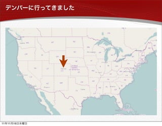
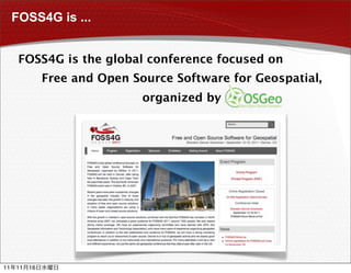
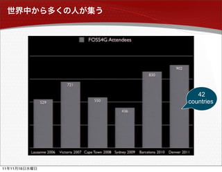
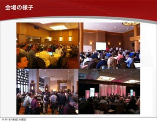
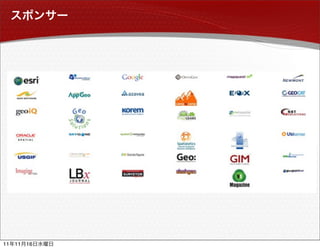
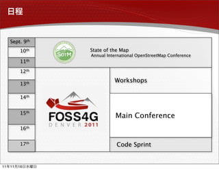
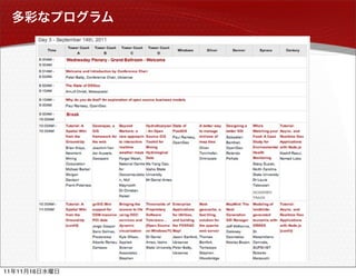
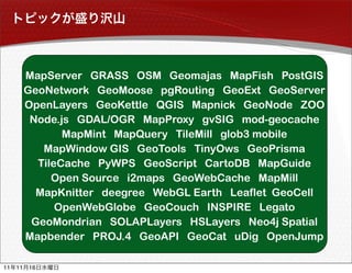
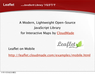
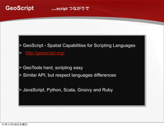
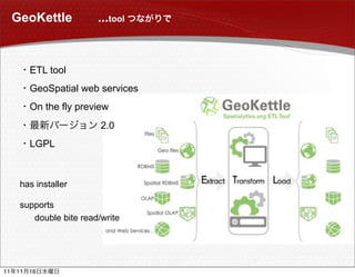
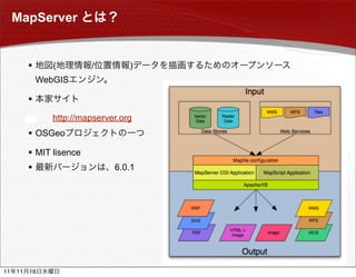
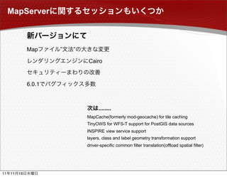
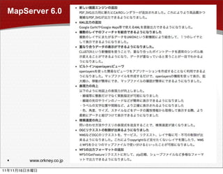
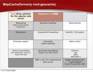
FOSS4G 2011 Denver


11   11   16
11   11   16
FOSS4G   ?


11   11   16
FOSS4G is ...


      FOSS4G is the global conference focused on
               Free and Open Source Software for Geospatial,
                               organized by


11   11   16
42
               countries


11   11   16
11   11   16
11   11   16
Sept. 9th
          10th   State of the Map
                 Annual International OpenStreetMap Conference 
          11th

          12th

          13th
                           Workshops

          14th


          15th
                            Main Conference
          16th


          17th              Code Sprint


11   11   16
11   11   16
MapServer GRASS OSM Geomajas MapFish PostGIS
          GeoNetwork GeoMoose pgRouting GeoExt GeoServer
          OpenLayers GeoKettle QGIS Mapnick GeoNode ZOO
           Node.js GDAL/OGR MapProxy gvSIG mod-geocache
                 MapMint MapQuery TileMill glob3 mobile
             MapWindow GIS GeoTools TinyOws GeoPrisma
            TileCache PyWPS GeoScript CartoDB  MapGuide
               Open Source i2maps GeoWebCache MapMill
            MapKnitter deegree WebGL Earth Leaflet GeoCell
                OpenWebGlobe GeoCouch INSPIRE Legato
           GeoMondrian SOLAPLayers HSLayers Neo4j Spatial
          Mapbender PROJ.4 GeoAPI GeoCat uDig OpenJump

11   11   16
 major was Agriculture
      Software Engineer             MapServer
      Web Mapping
                                     GeoServer
      @ Orkney
                                       PostGIS
                                    OpenLayers
                                       GeoExt


                                  Java, PHP,JavaScript
                               Apache, Tomcat, PostgreSQL


11   11   16
PostGIS


11   11   16
PostGIS


      PostgreSQL

     

                  Refractions Research

      GPL license
                   DB

                         1.5.3


11       11   16
PostGIS 2.0


           • “typmod” support
                CREATE TABLE my_spatial_table(
                    id INTEGER, name VARCHAR(64),
                    geo GEOMETRY(Point, 900913)
                 );
           • 3D/4D index
           • Topology support
           • Raster for Analysis
           • 3D objects support
           • Indexed Nearest-Neighbor Search


11   11   16
Tips for PostGIS Power Users


          Tips for Power Users
                 http://s3.opengeo.org/postgis-power.pdf


                                                        ST_Union()

                           ST_BuildArea()    ST_Polygonize()

                             ST_Dump()                    ST_GeometryN()

          invalid              ST_MakeValid()     2.0          ST_Buffer()

               SELECT ST_BuildArea(ST_Union(‘LINESTRING EMPTY’,

                                            ST_ExteriorRing(‘POLYGON((…))’)));


                                      ”Cluster on R-tree”      ”Cluster on GeoHash”

                                                                             …………


11   11   16
NOSQL


11   11   16
NOSQL


      Not Only SQL

                         SQL


     


      MongoDB, CouchDB


      Neo4j
             Java

     


11       11   16
Neo4j Spatial


                                    First Release in Sept. 2010


                       Core

                Storage, GeometryEncoder
                Search/RTree, Operations
                I/O(shapefile)
                                                    Extensions

                                                Geotools Datastore
                                                GeoServer & uDig
                 MongoDB
                 CouchDB
                      Geo


11   11   16
11   11   16
OpenLayers


                 JavaScript

     

     


11   11   16
OpenLayers


                Geo   JavaScript


                OpenLayers + Ext.js = GeoExt, Mapfish
                OpenLayers + jQuery = MapQuery


11   11   16
FOSS4G            OpenLayers


                OpenLayers

                              SNS   Tips


                OpenGeo


11   11   16
OpenLayers mobile


     What's new                                                  2.11
     Touch event support across the library (jQuery or Sencha)
     Pan and zoom the map
                                                                 CSS3, HTML5
     Draw, select ,drag, and modify vector
     Geolocation


                         OpenLayers.Handler.Pinch
                         OpenLayers.Control.Pinchzoom
                         OpenLayers.Control.ToouchNavigation
                         OpenLayers.Control.Geolocate


11   11   16
Leaflet     ...JavaScrit Library


                A Modern, Lightweight Open-Source
                             JavaScript Library
                 for Interactive Maps by CloudMade


          Leaflet on Mobile

          http://leaflet.cloudmade.com/examples/mobile.html


11   11   16
GeoScript                 ...script


               > GeoScript - Spatial Capabilities for Scripting Languages
               > http://geoscript.org/


               > GeoTools hard, scripting easy
               > Similar API, but respect languages differences


               > JavaScript, Python, Scala, Groovy and Ruby


11   11   16
GeoKettle           ...tool


          ETL tool
          GeoSpatial web services
          On the fly preview
                          2.0
          LGPL


      has installer

      supports
         double bite read/write


11   11   16
11   11   16
MapServer


                (        /         )
              WebGIS

          

                http://mapserver.org
           OSGeo

           MIT lisence
                               6.0.1


11   11   16
MapServer


               Map     ”   ”

                               Cairo


               6.0.1


                                     ........
                               MapCache(formerly mod-geocache) for tile caching
                               TinyOWS for WFS-T support for PostGIS data sources
                               INSPIRE view service support
                               layers, class and label geometry transformation support
                               driver-specific common filter translation(offload spatial filter)


11   11   16
MapServer 6.0


                  www.orkney.co.jp

11       11   16
MapCache(formerly mod-geocache)

               fast tiling solution          MapServer
               for the apache web
                      server

                     Meatatiling                Epiration handling             Watermaking
                 Higher level Locking
                     mechanism


                    Dimensions                FeatureInfo forwarding       FastCGI / CGI option


                 Proxying support                   Extensible                 Sqlite caches
                                                 custom hierarchy


                Vertical Assembling           Horizontal Assembling               Services
               Save bandwidth, request a      Support non-tiled clients              TMS
                    single tiled layer                                                  WMTS
                                                                                   WMS/WMS-C

                                           WMS is the only implemented     Image recompression
                                                   data source                / optimazation
                                                                          “mixed” format: PNG / JPEG


11   11   16
11   11   16

FOSS4G2011 Report

  • 1.
  • 2.
    11 11 16
  • 3.
    FOSS4G ? 11 11 16
  • 4.
    FOSS4G is ... FOSS4G is the global conference focused on Free and Open Source Software for Geospatial, organized by 11 11 16
  • 5.
    42 countries 11 11 16
  • 6.
    11 11 16
  • 7.
    11 11 16
  • 8.
    Sept. 9th 10th State of the Map Annual International OpenStreetMap Conference  11th 12th 13th Workshops 14th 15th Main Conference 16th 17th Code Sprint 11 11 16
  • 9.
    11 11 16
  • 10.
    MapServer GRASS OSMGeomajas MapFish PostGIS GeoNetwork GeoMoose pgRouting GeoExt GeoServer OpenLayers GeoKettle QGIS Mapnick GeoNode ZOO Node.js GDAL/OGR MapProxy gvSIG mod-geocache MapMint MapQuery TileMill glob3 mobile MapWindow GIS GeoTools TinyOws GeoPrisma TileCache PyWPS GeoScript CartoDB  MapGuide Open Source i2maps GeoWebCache MapMill MapKnitter deegree WebGL Earth Leaflet GeoCell OpenWebGlobe GeoCouch INSPIRE Legato GeoMondrian SOLAPLayers HSLayers Neo4j Spatial Mapbender PROJ.4 GeoAPI GeoCat uDig OpenJump 11 11 16
  • 11.
     major wasAgriculture  Software Engineer MapServer  Web Mapping GeoServer  @ Orkney PostGIS OpenLayers GeoExt Java, PHP,JavaScript Apache, Tomcat, PostgreSQL 11 11 16
  • 12.
  • 13.
    PostGIS  PostgreSQL   Refractions Research  GPL license  DB  1.5.3 11 11 16
  • 14.
    PostGIS 2.0 • “typmod” support CREATE TABLE my_spatial_table( id INTEGER, name VARCHAR(64), geo GEOMETRY(Point, 900913) ); • 3D/4D index • Topology support • Raster for Analysis • 3D objects support • Indexed Nearest-Neighbor Search 11 11 16
  • 15.
    Tips for PostGISPower Users Tips for Power Users http://s3.opengeo.org/postgis-power.pdf ST_Union() ST_BuildArea() ST_Polygonize() ST_Dump() ST_GeometryN() invalid ST_MakeValid() 2.0 ST_Buffer() SELECT ST_BuildArea(ST_Union(‘LINESTRING EMPTY’, ST_ExteriorRing(‘POLYGON((…))’))); ”Cluster on R-tree” ”Cluster on GeoHash” ………… 11 11 16
  • 16.
    NOSQL 11 11 16
  • 17.
    NOSQL  Not Only SQL  SQL   MongoDB, CouchDB  Neo4j  Java  11 11 16
  • 18.
    Neo4j Spatial First Release in Sept. 2010 Core       Storage, GeometryEncoder       Search/RTree, Operations       I/O(shapefile) Extensions      Geotools Datastore      GeoServer & uDig MongoDB CouchDB Geo 11 11 16
  • 19.
    11 11 16
  • 20.
    OpenLayers  JavaScript   11 11 16
  • 21.
    OpenLayers  Geo JavaScript  OpenLayers + Ext.js = GeoExt, Mapfish  OpenLayers + jQuery = MapQuery 11 11 16
  • 22.
    FOSS4G OpenLayers  OpenLayers SNS Tips  OpenGeo 11 11 16
  • 23.
    OpenLayers mobile What's new 2.11 Touch event support across the library (jQuery or Sencha) Pan and zoom the map CSS3, HTML5 Draw, select ,drag, and modify vector Geolocation OpenLayers.Handler.Pinch OpenLayers.Control.Pinchzoom OpenLayers.Control.ToouchNavigation OpenLayers.Control.Geolocate 11 11 16
  • 24.
    Leaflet ...JavaScrit Library A Modern, Lightweight Open-Source JavaScript Library for Interactive Maps by CloudMade Leaflet on Mobile http://leaflet.cloudmade.com/examples/mobile.html 11 11 16
  • 25.
    GeoScript ...script > GeoScript - Spatial Capabilities for Scripting Languages > http://geoscript.org/ > GeoTools hard, scripting easy > Similar API, but respect languages differences > JavaScript, Python, Scala, Groovy and Ruby 11 11 16
  • 26.
    GeoKettle ...tool ETL tool GeoSpatial web services On the fly preview 2.0 LGPL has installer supports double bite read/write 11 11 16
  • 27.
    11 11 16
  • 28.
    MapServer  ( / ) WebGIS   http://mapserver.org  OSGeo  MIT lisence  6.0.1 11 11 16
  • 29.
    MapServer Map ” ” Cairo 6.0.1 ........ MapCache(formerly mod-geocache) for tile caching TinyOWS for WFS-T support for PostGIS data sources INSPIRE view service support layers, class and label geometry transformation support driver-specific common filter translation(offload spatial filter) 11 11 16
  • 30.
    MapServer 6.0  www.orkney.co.jp 11 11 16
  • 31.
    MapCache(formerly mod-geocache) fast tiling solution MapServer for the apache web server Meatatiling Epiration handling Watermaking Higher level Locking mechanism Dimensions FeatureInfo forwarding FastCGI / CGI option Proxying support Extensible Sqlite caches custom hierarchy Vertical Assembling Horizontal Assembling Services Save bandwidth, request a Support non-tiled clients   TMS single tiled layer     WMTS     WMS/WMS-C WMS is the only implemented Image recompression data source / optimazation “mixed” format: PNG / JPEG 11 11 16
  • 32.
    11 11 16