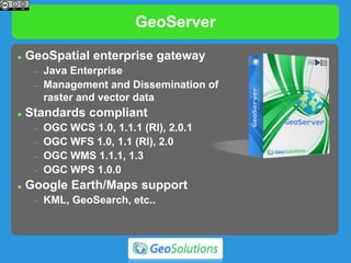
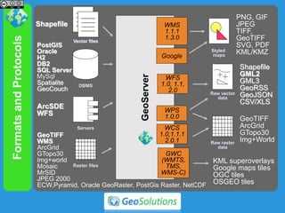
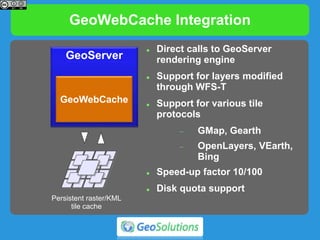
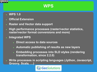
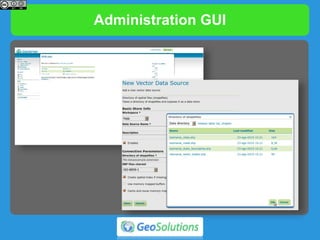
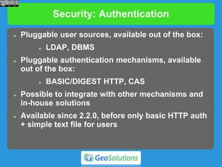
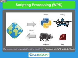
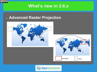
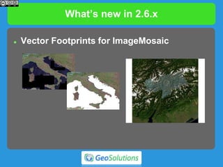
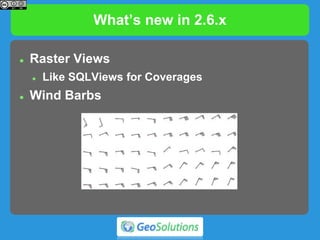
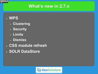
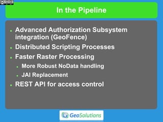
GeoServer
The Open Source Solution
for the interoperable management
of geospatial data
Ing. Andrea Aime, GeoSolutions
Ing. Simone Giannecchini, GeoSolutions
Dott. Mauro Bartolomeoli, GeoSolutions
Outline
 Quick intro to GeoServer
 What’s new in the 2.6.x and 2.7.x series
 What’s cooking for the future
GeoServer quick intro
GeoServer
 GeoSpatial enterprise gateway
 Java Enterprise
 Management and Dissemination of
raster and vector data
 Standards compliant
 OGC WCS 1.0, 1.1.1 (RI), 2.0.1
 OGC WFS 1.0, 1.1 (RI), 2.0
 OGC WMS 1.1.1, 1.3
 OGC WPS 1.0.0
 Google Earth/Maps support
 KML, GeoSearch, etc..
FormatsandProtocols
GeoServer
WFS
1.0, 1.1,
2.0
WMS
1.1.1
1.3.0
PostGIS
Oracle
H2
DB2
SQL Server
MySql
Spatialite
GeoCouch
Shapefile
----------
----------
---------
----------
----------
----------
---------
----------
----------
----------
---------
----------
ArcSDE
WFS
PNG, GIF
JPEG
TIFF,
GeoTIFF
SVG, PDF
KML/KMZ
Shapefile
GML2
GML3
GeoRSS
GeoJSON
CSV/XLS
Raw vector
data
Servers
Styled
maps
DBMS
Vector files
WCS
1.0,1.1.1
2.0.1
GeoTIFF
WMS
ArcGrid
GTopo30
Img+world
Mosaic
MrSID
JPEG 2000
ECW,Pyramid, Oracle GeoRaster, PostGis Raster, NetCDF
Raster files
Raw raster
data
GeoTIFF
ArcGrid
GTopo30
Img+World
GWC
(WMTS,
TMS,
WMS-C)
KML superoverlays
Google maps tiles
OGC tiles
OSGEO tiles
Google
WPS
1.0.0
Virtual services
 Expose different OGC services per workspace
 Styles and layer groups per workspace
 Have different
administrators per
workspace
 multi-tenancy
WMS
 Dissemination of Maps
 Fusing raster and vector data seamlessly
 Rule/scale driven rendering
 WMS 1.1.1 and 1.3 support
 SLD
 Basic support for SLD 1.1 and SE 1.1
 Full support for SLD 1.0
 CSS extension for compact styling (now in Pure Java)
 Many rendering extensions available
Rendering
GeoWebCache Integration
GeoServer
GeoWebCache
Persistent raster/KML
tile cache
 Direct calls to GeoServer
rendering engine
 Support for layers modified
through WFS-T
 Support for various tile
protocols
 GMap, Gearth
 OpenLayers, VEarth,
Bing
 Speed-up factor 10/100
 Disk quota support
KML/KMZ
TEMPORAL SERIES
KML EXTRUDE KML SUPEROVERLAY
WFS
 Dissemination and filtering of vector data
 WFS 1.0, 1.1 and 2.0
 Transaction and paging available in all versions
 Simplified filtering via CQL
 Formats:
 GML 2, 3.1 and 3.2
 CSV, Excel spreadsheet, GeoRSS, GeoJSON
 Shapefile (zipped)
 KML (since 2.4.0)
 Any other format supported by ogr2ogr (configurable)
Complex Feature*
 Application/community schemas
 Complex Features
 Attributes as sub-features
 Attributes as list of features
 Tree-like structure
 Mixing in a single tree heterogeneous data sources
WCS
 Raster data dissemination
 Raw raster data useful for analysis, no maps!
 Support for TIME, ELEVATION and custom dimensions
 WCS 1.0, 1.1.1 and 2.0
 Output formats
 GeoTiff, ArcGrid, NetCDF
 Extensions
 ELEVATION as band management
WPS
 WPS 1.0
 Official Extension
 Raster and Vector data support
 High performance processes (raster/vector statistics,
raster/vector format conversions and more)
 Integrated WPS
 Direct access to data sources
 Automatic publishing of results as new layers
 Embedding processes into SLD styles (rendering
transformation, since 2.2.0)
 Write processes in scripting languages (Jython, Javascript,
Groovy, Scala, …)
Administration GUI
RESTful Configuration
 Programmatic configuration of layers via REST
calls
 Workspaces, Data stores / coverage stores
 Layers and Styles, Service configurations
 Freemarker templates (incoming)
 Exposing internal configuration to remote clients
 Ajax - JavaScript friendly
 Various client libraries available in different
languages (Java, Python, Ruby, …).
 Example, geoserver-manager:
https://github.com/geosolutions-it/geoserver-manager
Security: Authentication
 Pluggable user sources, available out of the box:
 LDAP, DBMS
 Pluggable authentication mechanisms, available
out of the box:
 BASIC/DIGEST HTTP, CAS
 Possible to integrate with other mechanisms and
in-house solutions
 Available since 2.2.0, before only basic HTTP auth
+ simple text file for users
WMS: TIME and ELEVATION
TIME = 20100512T0000000Z
ELEVATION = 0.0
FeatureType Editor
WMS: Rendering Transformations
 On-the-fly data transformations
 Calling spatial analysis processes from SLD docs
 Optimized for performance
 Examples: on the fly contour lines, heat maps,
point clustering, point interpolation, GCP based
image rectification
CSS styling
 CSS inspired
styling language
 Styling for
humans
Importer (community)
 Graphical Workflow for preprocessing data
 Copy over, optimize, publish and style
Scripting Processing (WPS)
http://elogeo.nottingham.ac.uk/xmlui/handle/url/199 (Processing with WPS and SQL Views)
Improved Printing
Improved Printing
Improved Printing
What’s new in 2.6.x
What’s new in 2.6.x
 Advanced Raster Projection
What’s new in 2.6.x
 Vector Footprints for ImageMosaic
What’s new in 2.6.x
 Raster Views
 Like SQLViews for Coverages
 Wind Barbs
What’s new in 2.7.x
What’s new in 2.7.x
 Color composition and blending
What’s new in 2.7.x
 WPS
 Clustering
 Security
 Limits
 Dismiss
 CSS module refresh
 SOLR DataStore
In the Pipeline
 Advanced Authorization Subsystem
integration (GeoFence)
 Distributed Scripting Processes
 Faster Raster Processing
 More Robust NoData handling
 JAI Replacement
 REST API for access control
The End
Questions?
andrea.aime@geo-solutions.it
simone.giannecchini@geo-solutions.it
mauro.bartolomeoli@geo-solutions.it
The End
Other Questions?
Come to our booth at N20

Geoserver introduction, GeoBusiness 2015