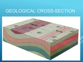
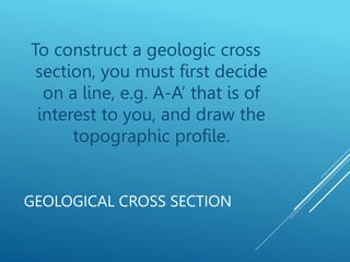
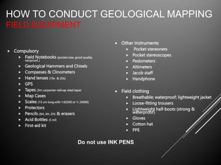
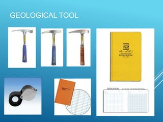
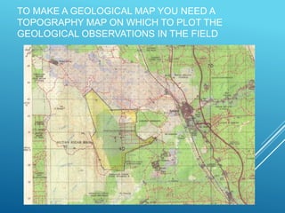
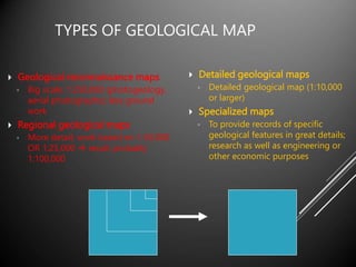
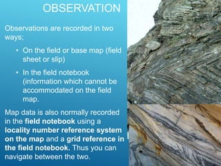
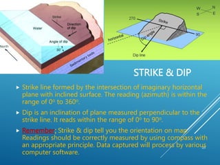
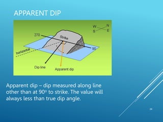
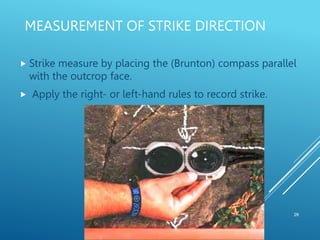
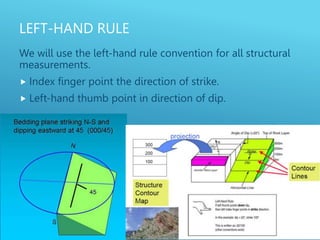
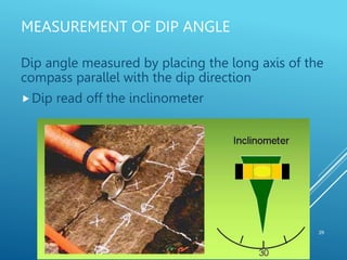
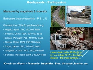
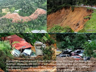
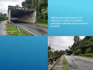
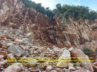
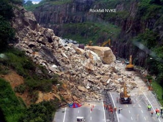
SlideShare a Scribd company logo
THE APPLICATION OF
GEOLOGICAL MAPPING IN
ENGINEERING GEOLOGY
Askury Abd Kadir @ Pak Cu
Geodream Academy & Adventure Sdn. Bhd
 Fieldwork is an important aspect of geology.
Learning to identify rocks in the field as well as
make geologic maps and cross-sections are
some of the fundamental skills a geologist must
learn.
 Fieldwork also allows students to develop
critical thinking and problem solving skills
through direct experiential learning.
 During this field school, students will be taught
basic geologic field methods through daily
exercises and will come out with an
understanding of the uses of these methods.
INTRODUCTION
The purpose of any geological field mapping is to make a
geological description of an area & to collect rock
samples (data).
 The data to be collected will to some degree depend on the type of
the project, but an exact geological description will always be of
great value.
 During the mapping it is often necessary to take samples of rocks
and minerals for analysis in the laboratory.
 The data from the field mapping should be presented in a report. In
the description it is important to distinguish clearly between the
direct observations and the evaluation of these observations.
 The report from the field mapping should try to answer the
questions proposed by the client. It is also important to point out the
uncertainties concerning the conclusions and provide
recommendations for further investigations to get more reliable
results.
GEOLOGICAL FIELD MAPPING
Mapping projects allow field
Geologist to develop
advanced skills in topographic
map reading, geologic
observation, and the
construction of geologic maps
& cross-section
THE PRIMARY FOCUS OF
GEOLOGIC MAPPING
GEOLOGIC CROSS SECTION
is a cross-sectional view along a line drawn
through a portion of a geologic map.
 In other words, if you could slice through a portion of the earth, pull
away one half, and look at it from the side, the surface would be a
geologic cross section.
is very useful for geologists when analyzing
numerous problems.
MAP & CROSS SECTION
GEOLOGICAL CROSS-SECTION
GEOLOGICAL CROSS SECTION
To construct a geologic cross
section, you must first decide
on a line, e.g. A-A’ that is of
interest to you, and draw the
topographic profile.
 Compulsory
 Field Notebooks (pocket size, good quality,
rainproof..)
 Geological Hammers and Chisels
 Compasses & Clinometers
 Hand lenses (10x & 20x)
 GPS
 Tapes (3m carpenter roll-up steel tape)
 Map Cases
 Scales (15 cm long with 1:62500 or 1: 24000)
 Protectors
 Pencils (6H, 4H, 2H) & erasers
 Acid Bottles (5 ml)
 First-aid kit
 Other Instruments
 Pocket stereonets
 Pocket stereoscopes
 Pedometers
 Altimeters
 Jacob staff
 Handphone
 Field clothing
 Breathable; waterproof; lightweight jacket
 Loose-fitting trousers
 Lightweight half-boots (strong &
waterproof)
 Gloves
 Cotton hat
 PPE
HOW TO CONDUCT GEOLOGICAL MAPPING
FIELD EQUIPMENT
Do not use INK PENS
GEOLOGICAL TOOL
 Geological fieldwork involves some level of risk; one part of this may come
from chance events that are unpredictable and little can be done about it;
another part of the risk, however, can be greatly reduced by awareness of
hazards and good judgements based on experience.
 Persons undertaking field work must assess the risk, as far as possible, and
this will vary in accordance with weather, cliff and sea conditions on the day
and the experience, age, fitness and other characteristics of the persons.
 Appropriate safety and first-aid equipment should be taken, and ideally
mobile phones should be available.
 Permission should be sought for entry into private land and clearly no
damage should take place.
 Attention should be paid to weather warnings, local warnings and danger
signs.
SAFETY
TO MAKE A GEOLOGICAL MAP YOU NEED A
TOPOGRAPHY MAP ON WHICH TO PLOT THE
GEOLOGICAL OBSERVATIONS IN THE FIELD
 Geological reconnaissance maps
◦ Big scale; 1:250,000 (photogeology,
aerial photographs); less ground
work
 Regional geological maps
◦ More detail; work based on 1:50,000
OR 1:25,000  result probably
1:100,000
 Detailed geological maps
◦ Detailed geological map (1:10,000
or larger)
 Specialized maps
◦ To provide records of specific
geological features in great details;
research as well as engineering or
other economic purposes
TYPES OF GEOLOGICAL MAP
TOPOGRAPHIC BASE MAPS
JUPEM:
AERIAL PHOTOGRAPH
GOOGLE EARTH
 Very important factor
◦ Must be big enough to see the features
◦ Must be small enough to minimize the no of photos
 1:50,000 – 1:100,000 – cover very large area – best for
feasibility studies, choose “area of interest” etc
 1:20,000 – 1:25,000 – produce mosaic of “area of interest”,
route selection, terrain evaluation & landuses.
 1:10,000-1:15,000 – Ideal for detail photo interpretation.
 1:2,500-1:5,000 – Large scale plan production.
SCALE
HOW TO LOCATE?
There are three method can be used depending to the terrain
and condition.
• Triangulate (use compass to take bearings on three
prominent features). Aim for small (< 1mm) triangle of
error.
• Pace and bearing (traversing). Pace out distance from
known feature marked on map (use compass to take
bearing on feature and mark faintly on map so line can
easily be removed)
• GPS - widely used in industry and extremely very popular.
LOCATE
On a 1:10,000 map, 1 cm on the map represents 100 m
in the field. You should be able to pinpoint yourself within
10 m in the field, so when you translate this to the map,
the margin for error is 1 mm
Remember, when mapping at 1:10,000 scale, millimetre
accuracy is expected
19
RIVER
TRAVERSING
1
2
3
4
5
6
7 8
9
10
11
12
13
ST. DESCRIPTION
1 Carbonaceous shale outcrop. B/S= 330/47NE.
Rock sample.
2 As above. B/S= 320/45NE. Silt and concentrate
samples.
3 Interbedded carbonaceous shale and thinly
layered gray sandstone. B/S= 300/40 NE. Stream
sediment sample.
4 Outcrop of massive sandstone, yellowish gray.
B/S= 310/45NE. Clearly displays thinly laminated
sequence.
5 As above. B/S= 330/65NE
6 Carbonaceous shale outcropping at waterfall.
B/S= 290/65NNE. Bivalve fossils are spotted with
complete preservation. Fossil sample.
7 Huge outcrop of gray sandstone. B/S= 70/70SE.
Silt sample.
8 As above. B/S= 45/75SE. Silt sample
9 Small outcrop of carbonaceous shale. B/S=
50/60SE
10 As above. B/S= 55/60SE
11 As above. Big outcrop of interbedded shale and
sandstone with folding. B/S= 330/56NE
12 Outcrop of massive calc-silicate hornfels. F/S=
300/56SE. Rock sample
20
METHODOLOGY TO CAPTURE MAP
REFERENCE
21
22
17 18
A
B
C
D
E
QT
A = QT 172213
B = QT 175215
C = QT 173220
D = QT 177210
E = QT 180213
Map references are the
spatial data for digital
mapping via GIS. It
shows the exact
location on map using
Easting & Northing
OBSERVATION
Spend some time looking at the exposure. What is the
rock type? Mineral composition? Grain size? Texture?
Geological structure? Bedding? Foliation? Tectonic
fabric? Fractures? Sedimentary structures? Fossils?
OBSERVATION
Observations are recorded in two
ways;
• On the field or base map (field
sheet or slip)
• In the field notebook
(information which cannot be
accommodated on the field
map.
Map data is also normally recorded
in the field notebook using a
locality number reference system
on the map and a grid reference in
the field notebook. Thus you can
navigate between the two.
STRIKE & DIP
23
 Strike line formed by the intersection of imaginary horizontal
plane with inclined surface. The reading (azimuth) is within the
range of 0o to 360o.
 Dip is an inclination of plane measured perpendicular to the
strike line. It reads within the range of 0o to 90o.
 Remember: Strike & dip tell you the orientation on map.
Readings should be correctly measured by using compass with
an appropriate principle. Data captured will process by various
computer software.
APPARENT DIP
24
Apparent dip – dip measured along line
other than at 90o to strike. The value will
always less than true dip angle.
MEASUREMENT OF ORIENTATION DATA
25
 Strike and trend are measured with a compass.
 Dip and plunge are measured using an inclinometer.
MEASUREMENT OF STRIKE DIRECTION
26
 Strike measure by placing the (Brunton) compass parallel
with the outcrop face.
 Apply the right- or left-hand rules to record strike.
LEFT-HAND RULE
We will use the left-hand rule convention for all structural
measurements.
 Index finger point the direction of strike.
 Left-hand thumb point in direction of dip.
RIGHT-HAND RULES
28
The usage of right-hand rule convention for all
structural measurements.
Right-hand thumb point in direction of strike.
Fingers point the direction of dip.
MEASUREMENT OF DIP ANGLE
29
Dip angle measured by placing the long axis of the
compass parallel with the dip direction
Dip read off the inclinometer
Geohazards
Earthquakes
Reactive soils
Volcanic eruptions
Tsunamis
Floods
Landslides & rockfalls
Karst and soluble rocks
Salinity
Soil erosion
Coastal erosion
Sinkholes Acidic soils
Contaminated soils
Permafrost
Salt water intrusion
Quicksand
Geohazards – Volcanic hazards
Hawaii
La Palma, Spain
Semeru eruption
Semeru eruption
Pyroclastic flows
Lahars
Gas emissions
Dust
Climate changes
Environmental devastation
Geohazards - Earthquakes
Measured by magnitude & intensity
Earthquake wave components – P, S, L, R
Greatest loss of life for geohazards e.g.
• Aleppo, Syria 1138, 230,000 dead
• Shaanxi, China 1556, 830,000 dead
• Lisbon, Portugal 1755, 100,000 dead
• Gansu, China 1920, 200,000 dead
• Tokyo, Japan 1923, 140,000 dead
• Tangshan, China 1976, 242,000 dead
• Sumatra, Indonesia 2004, 230,000 dead
Knock-on effects = Tsunamis, landslides, fires, diseases, famine, etc.
Latest death toll is 96 life @ M
8.1 on 8 Sept 2017 in Southern
Mexico – the most powerful ..
Japan
11th March
2011
ML 9.0
20,448 dead
Tsunami
Fires
Tsunami
Canterbury, N.Z.
2010 & 2011
Ranau earthquake
2015 Sabah Earthquake
Date 5 June 2015
Origin time 07:15:43 MST (UTC+08:00)
Duration 30 seconds
Magnitude 6.0 (Mw) (USGS)
5.9 (Mw) (MetMalaysia)
Depth 10 km
Epicenter 5.980°N 116.525°E
Type Normal
Areas affected West Coast & Interior Division
(Mount Kinabalu area), Sabah
Total damage Building and infrastructure damage,
landslides & geological changes,
$2.84 billion (USD)
Max. intensity VII (Very strong)
Landslides Yes
Aftershocks 130 (As of 1 April 2016)
Casualties 18 deaths; 11 wounded
Geohazards - Earthquakes
Likelihood/Probability
 Historic data collection and collation
 Seismic record
 Geology mapping
 Fault mapping
 Soil mapping
 Microseismical surveys
Consequence/Outcome
 Historic data collection and collation
 Building susceptibility (homes, hospitals, public offices…)
 Infrastructure susceptibility (road, bridges, sewerage…)
 Utility conduits (gas, power, water, telecommunications…)
 Industry (refineries, biohazards, nuclear hazards…)
 Emergency services (police, ambulance, fire…)
Geohazards - Landslides
Landslide mechanics
Geohazards - Landslides
Destabilising forces
1. Gravity
2. Water
4. Undercutting
3. Loads
Landslide mechanics
Geohazards - Landslides
Mitigation measures on slope stabilization
3. Drain the slope
1. Retain the slope
2. Unload the slope
4. Anchor the slope
Landslide mechanics
Simpang Pulai – Cameron Highlands
Fraser Hill
Bukit Antarabangsa
Kinabalu Park
A landslide occurred around 2.00am of 16 December 2022 near the Batang Kali,
Selangor, displacing 450,000 m3 of soil and burying campsites at an organic farm.
The accident trapped 92 people under the collapsed slope; most were campers
from the farm. Thirty-one people were killed and 61 were rescued.
Half-tunnel constructed at E-W
Highway to rectify the sensitive
geological materials due to dormant
landslide.
Rockfall incident happened at 9.15am on 8 March 2022, claimed two life and two
injured at Simpang Pulai, Ipoh. There were two excavators buried under the huge
boulders rolled down from the quarry face, weighing 50 to 100 tonnes.
Rockfall NVKE
Geohazards – Soil erosion by water & wind
Elaine
Surface erosion
Erosion mechanics
Sheet erosion
Universal Soil Loss Equation
Annual soil loss (t/ha/yr)
= Rainfall erosivity
x soil erodibility
x slope length
x slope gradient
x support practice factor
x cover and crop management
Rill erosion
Channels < 0.3m depth
Gully erosion
Sediment transport
Water flow
Headward erosion
Channels > 0.3m depth
Tunnel erosion
Soil aggregate stability
(slaking and dispersion)
Geohazards – Soil erosion by water
Soil Erosion
Ground subsidence
Sinkholes, collapsing ground caused by:
 Groundwater extraction from confined aquifers
 Dissolution of aquifer materials (e.g. karst processes)
 Dispersive or slaking soils
 Man made cavities (e.g. tunnel, Mines) – not natural
Karst processes
Dissolution Process
Limestone cavities result from
dissolution of the aquifer by
groundwater. The cavities grow larger
over time and then collapse to form
dolines.
CaCO3 + H2CO3  Ca(OH)2 + 2CO2
Sinkhole in Guatemala City
Sunday May 30th 2010
Sinkhole
20m diameter, 30m deep
Similar event February 2007
Geohazards - Subsidence
• Subsidence over old mine workings
(Ballarat, Bendigo, Wonthaggi)
abandoned quarries (Yarraville),
• Karst solution cavities (Port
Campbell, Peterborough),
• Dispersive soils (Kennet River,
Melton, Parwan Valley)
Mexico City
• Subsidence due to groundwater
extraction threatens historic buildings
such as the cathedral (1573 – 1813).
• Similar thing happen in Bangkok upon the
over-pumping of groundwater led to
subsidence. Now Bangkok is almost
below sea level.
About 1m recent subsidence
Plumb-bob to check restoration success
Geohazards – Acid sulfate soils
Acid sulfate soils (ASS)
Coastal ASS (CASS)
Inland ASS (IASS)
Potential ASS (PASS)
Actual ASS (AASS)
 Contain iron sulfides (e.g. pyrite)
 Produce sulfuric acid when disturbed
 Irreversible process
 Severe damage to built and natural environment
 Often contaminate soils with other toxins
 AASS has pH <4
Breamlea
ARD – Acid Rock Drainage
AMD – Acid Mine Drainage
Geohazards – Acid sulfate soils
Geohazards – Reactive soils
• Soils which swell when wetted and
shrink when dried.
• Victoria’s most prevalent geohazard
• Costs $millions per year in damage to
houses, roads, utility services, etc.
• Whole industry dedicated to soil tests
for building.
• Australian Standard AS2870
• Soils which contain certain clay
minerals usually montmorillonite, but
may be others.
• Easily identified by soil classification
tests.
• Managed by building codes and
specialist engineering solutions.
• Can be stabilised by the use of soil
additives.
Summary
Landscapes are dynamic. Geohazards are natural
processes
Identify the processes that occur in different landscapes,
and the main factors (natural or man-made) that are
acting on those processes
Assess the risk to assets (life, property, environment,
social, etc.)
Where risk is unacceptable, reduce the risk by
changing the likelihood of an event or its consequence
Geohazards can also be man-made (anthropogenic)
ENJOY YOUR MAPPING

More Related Content

Similar to Geomapping in Engineering Geology UMT.pptx

Geological mapping in Exploration Geology( surface and subsurface)
Geological mapping in Exploration Geology( surface and subsurface)Geological mapping in Exploration Geology( surface and subsurface)
Geological mapping in Exploration Geology( surface and subsurface)HARITHA ANIL KUMAR
 
gis in natural disaster management geo hazards
gis in natural disaster management  geo hazardsgis in natural disaster management  geo hazards
gis in natural disaster management geo hazardsSoumik Chakraborty
 
Landslide monitoring systems & techniques
Landslide monitoring systems & techniquesLandslide monitoring systems & techniques
Landslide monitoring systems & techniquesmaneeb
 
2. VULNERABILITY ASSESSMENT OF SOIL EROSION USING GEOSPATIAL TECHNIQUES
2. VULNERABILITY ASSESSMENT OF SOIL EROSION USING GEOSPATIAL TECHNIQUES2. VULNERABILITY ASSESSMENT OF SOIL EROSION USING GEOSPATIAL TECHNIQUES
2. VULNERABILITY ASSESSMENT OF SOIL EROSION USING GEOSPATIAL TECHNIQUESDr. Ravinder Jangra
 
Projections and coordinate system
Projections and coordinate systemProjections and coordinate system
Projections and coordinate systemMohsin Siddique
 
Controlled assessment booklet 2014 update
Controlled assessment booklet 2014 updateControlled assessment booklet 2014 update
Controlled assessment booklet 2014 updateMrs Coles
 
Introduction about seismic methods.pptx
Introduction about seismic methods.pptxIntroduction about seismic methods.pptx
Introduction about seismic methods.pptxssuser6ceee1
 
E030102031037
E030102031037E030102031037
E030102031037theijes
 
Directional drilling Introduction
Directional drilling IntroductionDirectional drilling Introduction
Directional drilling IntroductionGEx OliNesia
 
Lecture 02 types of surveying
Lecture 02 types of surveyingLecture 02 types of surveying
Lecture 02 types of surveyingRehan Hanif
 

Similar to Geomapping in Engineering Geology UMT.pptx (20)

Jaysukh C Songara
Jaysukh C SongaraJaysukh C Songara
Jaysukh C Songara
 
GEOGRAPHY GRADE 12 ATP
GEOGRAPHY GRADE 12 ATPGEOGRAPHY GRADE 12 ATP
GEOGRAPHY GRADE 12 ATP
 
GEODESIA
GEODESIAGEODESIA
GEODESIA
 
Geological mapping in Exploration Geology( surface and subsurface)
Geological mapping in Exploration Geology( surface and subsurface)Geological mapping in Exploration Geology( surface and subsurface)
Geological mapping in Exploration Geology( surface and subsurface)
 
gis in natural disaster management geo hazards
gis in natural disaster management  geo hazardsgis in natural disaster management  geo hazards
gis in natural disaster management geo hazards
 
Landslide monitoring systems & techniques
Landslide monitoring systems & techniquesLandslide monitoring systems & techniques
Landslide monitoring systems & techniques
 
Surveying (introduction)
Surveying (introduction)Surveying (introduction)
Surveying (introduction)
 
Geography of microwave survey
Geography of microwave surveyGeography of microwave survey
Geography of microwave survey
 
A2100107
A2100107A2100107
A2100107
 
Scope of studying engineering geology
Scope of studying engineering geologyScope of studying engineering geology
Scope of studying engineering geology
 
2. VULNERABILITY ASSESSMENT OF SOIL EROSION USING GEOSPATIAL TECHNIQUES
2. VULNERABILITY ASSESSMENT OF SOIL EROSION USING GEOSPATIAL TECHNIQUES2. VULNERABILITY ASSESSMENT OF SOIL EROSION USING GEOSPATIAL TECHNIQUES
2. VULNERABILITY ASSESSMENT OF SOIL EROSION USING GEOSPATIAL TECHNIQUES
 
Projections and coordinate system
Projections and coordinate systemProjections and coordinate system
Projections and coordinate system
 
Controlled assessment booklet 2014 update
Controlled assessment booklet 2014 updateControlled assessment booklet 2014 update
Controlled assessment booklet 2014 update
 
Introduction about seismic methods.pptx
Introduction about seismic methods.pptxIntroduction about seismic methods.pptx
Introduction about seismic methods.pptx
 
E030102031037
E030102031037E030102031037
E030102031037
 
Landslides mapping
Landslides mappingLandslides mapping
Landslides mapping
 
TYPES OF SURVEYING.docx
TYPES OF SURVEYING.docxTYPES OF SURVEYING.docx
TYPES OF SURVEYING.docx
 
Directional drilling Introduction
Directional drilling IntroductionDirectional drilling Introduction
Directional drilling Introduction
 
Introduction of Surveying
Introduction of Surveying Introduction of Surveying
Introduction of Surveying
 
Lecture 02 types of surveying
Lecture 02 types of surveyingLecture 02 types of surveying
Lecture 02 types of surveying
 

Recently uploaded

Comparative structure of adrenal gland in vertebrates
Comparative structure of adrenal gland in vertebratesComparative structure of adrenal gland in vertebrates
Comparative structure of adrenal gland in vertebratessachin783648
 
FAIR & AI Ready KGs for Explainable Predictions
FAIR & AI Ready KGs for Explainable PredictionsFAIR & AI Ready KGs for Explainable Predictions
FAIR & AI Ready KGs for Explainable PredictionsMichel Dumontier
 
Structures and textures of metamorphic rocks
Structures and textures of metamorphic rocksStructures and textures of metamorphic rocks
Structures and textures of metamorphic rockskumarmathi863
 
SCHIZOPHRENIA Disorder/ Brain Disorder.pdf
SCHIZOPHRENIA Disorder/ Brain Disorder.pdfSCHIZOPHRENIA Disorder/ Brain Disorder.pdf
SCHIZOPHRENIA Disorder/ Brain Disorder.pdfSELF-EXPLANATORY
 
insect taxonomy importance systematics and classification
insect taxonomy importance systematics and classificationinsect taxonomy importance systematics and classification
insect taxonomy importance systematics and classificationanitaento25
 
word2vec, node2vec, graph2vec, X2vec: Towards a Theory of Vector Embeddings o...
word2vec, node2vec, graph2vec, X2vec: Towards a Theory of Vector Embeddings o...word2vec, node2vec, graph2vec, X2vec: Towards a Theory of Vector Embeddings o...
word2vec, node2vec, graph2vec, X2vec: Towards a Theory of Vector Embeddings o...Subhajit Sahu
 
SAMPLING.pptx for analystical chemistry sample techniques
SAMPLING.pptx for analystical chemistry sample techniquesSAMPLING.pptx for analystical chemistry sample techniques
SAMPLING.pptx for analystical chemistry sample techniquesrodneykiptoo8
 
Gliese 12 b: A Temperate Earth-sized Planet at 12 pc Ideal for Atmospheric Tr...
Gliese 12 b: A Temperate Earth-sized Planet at 12 pc Ideal for Atmospheric Tr...Gliese 12 b: A Temperate Earth-sized Planet at 12 pc Ideal for Atmospheric Tr...
Gliese 12 b: A Temperate Earth-sized Planet at 12 pc Ideal for Atmospheric Tr...Sérgio Sacani
 
National Biodiversity protection initiatives and Convention on Biological Di...
National Biodiversity protection initiatives and  Convention on Biological Di...National Biodiversity protection initiatives and  Convention on Biological Di...
National Biodiversity protection initiatives and Convention on Biological Di...PABOLU TEJASREE
 
Predicting property prices with machine learning algorithms.pdf
Predicting property prices with machine learning algorithms.pdfPredicting property prices with machine learning algorithms.pdf
Predicting property prices with machine learning algorithms.pdfbinhminhvu04
 
THYROID-PARATHYROID medical surgical nursing
THYROID-PARATHYROID medical surgical nursingTHYROID-PARATHYROID medical surgical nursing
THYROID-PARATHYROID medical surgical nursingJocelyn Atis
 
Lab report on liquid viscosity of glycerin
Lab report on liquid viscosity of glycerinLab report on liquid viscosity of glycerin
Lab report on liquid viscosity of glycerinossaicprecious19
 
extra-chromosomal-inheritance[1].pptx.pdfpdf
extra-chromosomal-inheritance[1].pptx.pdfpdfextra-chromosomal-inheritance[1].pptx.pdfpdf
extra-chromosomal-inheritance[1].pptx.pdfpdfDiyaBiswas10
 
Hemoglobin metabolism_pathophysiology.pptx
Hemoglobin metabolism_pathophysiology.pptxHemoglobin metabolism_pathophysiology.pptx
Hemoglobin metabolism_pathophysiology.pptxmuralinath2
 
ESR_factors_affect-clinic significance-Pathysiology.pptx
ESR_factors_affect-clinic significance-Pathysiology.pptxESR_factors_affect-clinic significance-Pathysiology.pptx
ESR_factors_affect-clinic significance-Pathysiology.pptxmuralinath2
 
Anemia_ different types_causes_ conditions
Anemia_ different types_causes_ conditionsAnemia_ different types_causes_ conditions
Anemia_ different types_causes_ conditionsmuralinath2
 
Citrus Greening Disease and its Management
Citrus Greening Disease and its ManagementCitrus Greening Disease and its Management
Citrus Greening Disease and its Managementsubedisuryaofficial
 
Mammalian Pineal Body Structure and Also Functions
Mammalian Pineal Body Structure and Also FunctionsMammalian Pineal Body Structure and Also Functions
Mammalian Pineal Body Structure and Also FunctionsYOGESH DOGRA
 
Pests of sugarcane_Binomics_IPM_Dr.UPR.pdf
Pests of sugarcane_Binomics_IPM_Dr.UPR.pdfPests of sugarcane_Binomics_IPM_Dr.UPR.pdf
Pests of sugarcane_Binomics_IPM_Dr.UPR.pdfPirithiRaju
 
Penicillin...........................pptx
Penicillin...........................pptxPenicillin...........................pptx
Penicillin...........................pptxCherry
 

Recently uploaded (20)

Comparative structure of adrenal gland in vertebrates
Comparative structure of adrenal gland in vertebratesComparative structure of adrenal gland in vertebrates
Comparative structure of adrenal gland in vertebrates
 
FAIR & AI Ready KGs for Explainable Predictions
FAIR & AI Ready KGs for Explainable PredictionsFAIR & AI Ready KGs for Explainable Predictions
FAIR & AI Ready KGs for Explainable Predictions
 
Structures and textures of metamorphic rocks
Structures and textures of metamorphic rocksStructures and textures of metamorphic rocks
Structures and textures of metamorphic rocks
 
SCHIZOPHRENIA Disorder/ Brain Disorder.pdf
SCHIZOPHRENIA Disorder/ Brain Disorder.pdfSCHIZOPHRENIA Disorder/ Brain Disorder.pdf
SCHIZOPHRENIA Disorder/ Brain Disorder.pdf
 
insect taxonomy importance systematics and classification
insect taxonomy importance systematics and classificationinsect taxonomy importance systematics and classification
insect taxonomy importance systematics and classification
 
word2vec, node2vec, graph2vec, X2vec: Towards a Theory of Vector Embeddings o...
word2vec, node2vec, graph2vec, X2vec: Towards a Theory of Vector Embeddings o...word2vec, node2vec, graph2vec, X2vec: Towards a Theory of Vector Embeddings o...
word2vec, node2vec, graph2vec, X2vec: Towards a Theory of Vector Embeddings o...
 
SAMPLING.pptx for analystical chemistry sample techniques
SAMPLING.pptx for analystical chemistry sample techniquesSAMPLING.pptx for analystical chemistry sample techniques
SAMPLING.pptx for analystical chemistry sample techniques
 
Gliese 12 b: A Temperate Earth-sized Planet at 12 pc Ideal for Atmospheric Tr...
Gliese 12 b: A Temperate Earth-sized Planet at 12 pc Ideal for Atmospheric Tr...Gliese 12 b: A Temperate Earth-sized Planet at 12 pc Ideal for Atmospheric Tr...
Gliese 12 b: A Temperate Earth-sized Planet at 12 pc Ideal for Atmospheric Tr...
 
National Biodiversity protection initiatives and Convention on Biological Di...
National Biodiversity protection initiatives and  Convention on Biological Di...National Biodiversity protection initiatives and  Convention on Biological Di...
National Biodiversity protection initiatives and Convention on Biological Di...
 
Predicting property prices with machine learning algorithms.pdf
Predicting property prices with machine learning algorithms.pdfPredicting property prices with machine learning algorithms.pdf
Predicting property prices with machine learning algorithms.pdf
 
THYROID-PARATHYROID medical surgical nursing
THYROID-PARATHYROID medical surgical nursingTHYROID-PARATHYROID medical surgical nursing
THYROID-PARATHYROID medical surgical nursing
 
Lab report on liquid viscosity of glycerin
Lab report on liquid viscosity of glycerinLab report on liquid viscosity of glycerin
Lab report on liquid viscosity of glycerin
 
extra-chromosomal-inheritance[1].pptx.pdfpdf
extra-chromosomal-inheritance[1].pptx.pdfpdfextra-chromosomal-inheritance[1].pptx.pdfpdf
extra-chromosomal-inheritance[1].pptx.pdfpdf
 
Hemoglobin metabolism_pathophysiology.pptx
Hemoglobin metabolism_pathophysiology.pptxHemoglobin metabolism_pathophysiology.pptx
Hemoglobin metabolism_pathophysiology.pptx
 
ESR_factors_affect-clinic significance-Pathysiology.pptx
ESR_factors_affect-clinic significance-Pathysiology.pptxESR_factors_affect-clinic significance-Pathysiology.pptx
ESR_factors_affect-clinic significance-Pathysiology.pptx
 
Anemia_ different types_causes_ conditions
Anemia_ different types_causes_ conditionsAnemia_ different types_causes_ conditions
Anemia_ different types_causes_ conditions
 
Citrus Greening Disease and its Management
Citrus Greening Disease and its ManagementCitrus Greening Disease and its Management
Citrus Greening Disease and its Management
 
Mammalian Pineal Body Structure and Also Functions
Mammalian Pineal Body Structure and Also FunctionsMammalian Pineal Body Structure and Also Functions
Mammalian Pineal Body Structure and Also Functions
 
Pests of sugarcane_Binomics_IPM_Dr.UPR.pdf
Pests of sugarcane_Binomics_IPM_Dr.UPR.pdfPests of sugarcane_Binomics_IPM_Dr.UPR.pdf
Pests of sugarcane_Binomics_IPM_Dr.UPR.pdf
 
Penicillin...........................pptx
Penicillin...........................pptxPenicillin...........................pptx
Penicillin...........................pptx
 

Geomapping in Engineering Geology UMT.pptx

  • 1. THE APPLICATION OF GEOLOGICAL MAPPING IN ENGINEERING GEOLOGY Askury Abd Kadir @ Pak Cu Geodream Academy & Adventure Sdn. Bhd
  • 2.  Fieldwork is an important aspect of geology. Learning to identify rocks in the field as well as make geologic maps and cross-sections are some of the fundamental skills a geologist must learn.  Fieldwork also allows students to develop critical thinking and problem solving skills through direct experiential learning.  During this field school, students will be taught basic geologic field methods through daily exercises and will come out with an understanding of the uses of these methods. INTRODUCTION
  • 3. The purpose of any geological field mapping is to make a geological description of an area & to collect rock samples (data).  The data to be collected will to some degree depend on the type of the project, but an exact geological description will always be of great value.  During the mapping it is often necessary to take samples of rocks and minerals for analysis in the laboratory.  The data from the field mapping should be presented in a report. In the description it is important to distinguish clearly between the direct observations and the evaluation of these observations.  The report from the field mapping should try to answer the questions proposed by the client. It is also important to point out the uncertainties concerning the conclusions and provide recommendations for further investigations to get more reliable results. GEOLOGICAL FIELD MAPPING
  • 4. Mapping projects allow field Geologist to develop advanced skills in topographic map reading, geologic observation, and the construction of geologic maps & cross-section THE PRIMARY FOCUS OF GEOLOGIC MAPPING
  • 5. GEOLOGIC CROSS SECTION is a cross-sectional view along a line drawn through a portion of a geologic map.  In other words, if you could slice through a portion of the earth, pull away one half, and look at it from the side, the surface would be a geologic cross section. is very useful for geologists when analyzing numerous problems.
  • 6. MAP & CROSS SECTION GEOLOGICAL CROSS-SECTION
  • 7. GEOLOGICAL CROSS SECTION To construct a geologic cross section, you must first decide on a line, e.g. A-A’ that is of interest to you, and draw the topographic profile.
  • 8.  Compulsory  Field Notebooks (pocket size, good quality, rainproof..)  Geological Hammers and Chisels  Compasses & Clinometers  Hand lenses (10x & 20x)  GPS  Tapes (3m carpenter roll-up steel tape)  Map Cases  Scales (15 cm long with 1:62500 or 1: 24000)  Protectors  Pencils (6H, 4H, 2H) & erasers  Acid Bottles (5 ml)  First-aid kit  Other Instruments  Pocket stereonets  Pocket stereoscopes  Pedometers  Altimeters  Jacob staff  Handphone  Field clothing  Breathable; waterproof; lightweight jacket  Loose-fitting trousers  Lightweight half-boots (strong & waterproof)  Gloves  Cotton hat  PPE HOW TO CONDUCT GEOLOGICAL MAPPING FIELD EQUIPMENT Do not use INK PENS
  • 10.  Geological fieldwork involves some level of risk; one part of this may come from chance events that are unpredictable and little can be done about it; another part of the risk, however, can be greatly reduced by awareness of hazards and good judgements based on experience.  Persons undertaking field work must assess the risk, as far as possible, and this will vary in accordance with weather, cliff and sea conditions on the day and the experience, age, fitness and other characteristics of the persons.  Appropriate safety and first-aid equipment should be taken, and ideally mobile phones should be available.  Permission should be sought for entry into private land and clearly no damage should take place.  Attention should be paid to weather warnings, local warnings and danger signs. SAFETY
  • 11. TO MAKE A GEOLOGICAL MAP YOU NEED A TOPOGRAPHY MAP ON WHICH TO PLOT THE GEOLOGICAL OBSERVATIONS IN THE FIELD
  • 12.  Geological reconnaissance maps ◦ Big scale; 1:250,000 (photogeology, aerial photographs); less ground work  Regional geological maps ◦ More detail; work based on 1:50,000 OR 1:25,000  result probably 1:100,000  Detailed geological maps ◦ Detailed geological map (1:10,000 or larger)  Specialized maps ◦ To provide records of specific geological features in great details; research as well as engineering or other economic purposes TYPES OF GEOLOGICAL MAP
  • 16.  Very important factor ◦ Must be big enough to see the features ◦ Must be small enough to minimize the no of photos  1:50,000 – 1:100,000 – cover very large area – best for feasibility studies, choose “area of interest” etc  1:20,000 – 1:25,000 – produce mosaic of “area of interest”, route selection, terrain evaluation & landuses.  1:10,000-1:15,000 – Ideal for detail photo interpretation.  1:2,500-1:5,000 – Large scale plan production. SCALE
  • 17. HOW TO LOCATE? There are three method can be used depending to the terrain and condition. • Triangulate (use compass to take bearings on three prominent features). Aim for small (< 1mm) triangle of error. • Pace and bearing (traversing). Pace out distance from known feature marked on map (use compass to take bearing on feature and mark faintly on map so line can easily be removed) • GPS - widely used in industry and extremely very popular.
  • 18. LOCATE On a 1:10,000 map, 1 cm on the map represents 100 m in the field. You should be able to pinpoint yourself within 10 m in the field, so when you translate this to the map, the margin for error is 1 mm Remember, when mapping at 1:10,000 scale, millimetre accuracy is expected
  • 19. 19 RIVER TRAVERSING 1 2 3 4 5 6 7 8 9 10 11 12 13 ST. DESCRIPTION 1 Carbonaceous shale outcrop. B/S= 330/47NE. Rock sample. 2 As above. B/S= 320/45NE. Silt and concentrate samples. 3 Interbedded carbonaceous shale and thinly layered gray sandstone. B/S= 300/40 NE. Stream sediment sample. 4 Outcrop of massive sandstone, yellowish gray. B/S= 310/45NE. Clearly displays thinly laminated sequence. 5 As above. B/S= 330/65NE 6 Carbonaceous shale outcropping at waterfall. B/S= 290/65NNE. Bivalve fossils are spotted with complete preservation. Fossil sample. 7 Huge outcrop of gray sandstone. B/S= 70/70SE. Silt sample. 8 As above. B/S= 45/75SE. Silt sample 9 Small outcrop of carbonaceous shale. B/S= 50/60SE 10 As above. B/S= 55/60SE 11 As above. Big outcrop of interbedded shale and sandstone with folding. B/S= 330/56NE 12 Outcrop of massive calc-silicate hornfels. F/S= 300/56SE. Rock sample
  • 20. 20 METHODOLOGY TO CAPTURE MAP REFERENCE 21 22 17 18 A B C D E QT A = QT 172213 B = QT 175215 C = QT 173220 D = QT 177210 E = QT 180213 Map references are the spatial data for digital mapping via GIS. It shows the exact location on map using Easting & Northing
  • 21. OBSERVATION Spend some time looking at the exposure. What is the rock type? Mineral composition? Grain size? Texture? Geological structure? Bedding? Foliation? Tectonic fabric? Fractures? Sedimentary structures? Fossils?
  • 22. OBSERVATION Observations are recorded in two ways; • On the field or base map (field sheet or slip) • In the field notebook (information which cannot be accommodated on the field map. Map data is also normally recorded in the field notebook using a locality number reference system on the map and a grid reference in the field notebook. Thus you can navigate between the two.
  • 23. STRIKE & DIP 23  Strike line formed by the intersection of imaginary horizontal plane with inclined surface. The reading (azimuth) is within the range of 0o to 360o.  Dip is an inclination of plane measured perpendicular to the strike line. It reads within the range of 0o to 90o.  Remember: Strike & dip tell you the orientation on map. Readings should be correctly measured by using compass with an appropriate principle. Data captured will process by various computer software.
  • 24. APPARENT DIP 24 Apparent dip – dip measured along line other than at 90o to strike. The value will always less than true dip angle.
  • 25. MEASUREMENT OF ORIENTATION DATA 25  Strike and trend are measured with a compass.  Dip and plunge are measured using an inclinometer.
  • 26. MEASUREMENT OF STRIKE DIRECTION 26  Strike measure by placing the (Brunton) compass parallel with the outcrop face.  Apply the right- or left-hand rules to record strike.
  • 27. LEFT-HAND RULE We will use the left-hand rule convention for all structural measurements.  Index finger point the direction of strike.  Left-hand thumb point in direction of dip.
  • 28. RIGHT-HAND RULES 28 The usage of right-hand rule convention for all structural measurements. Right-hand thumb point in direction of strike. Fingers point the direction of dip.
  • 29. MEASUREMENT OF DIP ANGLE 29 Dip angle measured by placing the long axis of the compass parallel with the dip direction Dip read off the inclinometer
  • 30.
  • 31. Geohazards Earthquakes Reactive soils Volcanic eruptions Tsunamis Floods Landslides & rockfalls Karst and soluble rocks Salinity Soil erosion Coastal erosion Sinkholes Acidic soils Contaminated soils Permafrost Salt water intrusion Quicksand
  • 32. Geohazards – Volcanic hazards Hawaii La Palma, Spain Semeru eruption Semeru eruption Pyroclastic flows Lahars Gas emissions Dust Climate changes Environmental devastation
  • 33. Geohazards - Earthquakes Measured by magnitude & intensity Earthquake wave components – P, S, L, R Greatest loss of life for geohazards e.g. • Aleppo, Syria 1138, 230,000 dead • Shaanxi, China 1556, 830,000 dead • Lisbon, Portugal 1755, 100,000 dead • Gansu, China 1920, 200,000 dead • Tokyo, Japan 1923, 140,000 dead • Tangshan, China 1976, 242,000 dead • Sumatra, Indonesia 2004, 230,000 dead Knock-on effects = Tsunamis, landslides, fires, diseases, famine, etc. Latest death toll is 96 life @ M 8.1 on 8 Sept 2017 in Southern Mexico – the most powerful ..
  • 37.
  • 39. 2015 Sabah Earthquake Date 5 June 2015 Origin time 07:15:43 MST (UTC+08:00) Duration 30 seconds Magnitude 6.0 (Mw) (USGS) 5.9 (Mw) (MetMalaysia) Depth 10 km Epicenter 5.980°N 116.525°E Type Normal Areas affected West Coast & Interior Division (Mount Kinabalu area), Sabah Total damage Building and infrastructure damage, landslides & geological changes, $2.84 billion (USD) Max. intensity VII (Very strong) Landslides Yes Aftershocks 130 (As of 1 April 2016) Casualties 18 deaths; 11 wounded
  • 40. Geohazards - Earthquakes Likelihood/Probability  Historic data collection and collation  Seismic record  Geology mapping  Fault mapping  Soil mapping  Microseismical surveys Consequence/Outcome  Historic data collection and collation  Building susceptibility (homes, hospitals, public offices…)  Infrastructure susceptibility (road, bridges, sewerage…)  Utility conduits (gas, power, water, telecommunications…)  Industry (refineries, biohazards, nuclear hazards…)  Emergency services (police, ambulance, fire…)
  • 43. Destabilising forces 1. Gravity 2. Water 4. Undercutting 3. Loads Landslide mechanics Geohazards - Landslides
  • 44. Mitigation measures on slope stabilization 3. Drain the slope 1. Retain the slope 2. Unload the slope 4. Anchor the slope Landslide mechanics
  • 45. Simpang Pulai – Cameron Highlands Fraser Hill Bukit Antarabangsa Kinabalu Park
  • 46. A landslide occurred around 2.00am of 16 December 2022 near the Batang Kali, Selangor, displacing 450,000 m3 of soil and burying campsites at an organic farm. The accident trapped 92 people under the collapsed slope; most were campers from the farm. Thirty-one people were killed and 61 were rescued.
  • 47. Half-tunnel constructed at E-W Highway to rectify the sensitive geological materials due to dormant landslide.
  • 48. Rockfall incident happened at 9.15am on 8 March 2022, claimed two life and two injured at Simpang Pulai, Ipoh. There were two excavators buried under the huge boulders rolled down from the quarry face, weighing 50 to 100 tonnes.
  • 50. Geohazards – Soil erosion by water & wind Elaine Surface erosion
  • 51. Erosion mechanics Sheet erosion Universal Soil Loss Equation Annual soil loss (t/ha/yr) = Rainfall erosivity x soil erodibility x slope length x slope gradient x support practice factor x cover and crop management Rill erosion Channels < 0.3m depth Gully erosion Sediment transport Water flow Headward erosion Channels > 0.3m depth Tunnel erosion Soil aggregate stability (slaking and dispersion) Geohazards – Soil erosion by water
  • 53. Ground subsidence Sinkholes, collapsing ground caused by:  Groundwater extraction from confined aquifers  Dissolution of aquifer materials (e.g. karst processes)  Dispersive or slaking soils  Man made cavities (e.g. tunnel, Mines) – not natural
  • 54. Karst processes Dissolution Process Limestone cavities result from dissolution of the aquifer by groundwater. The cavities grow larger over time and then collapse to form dolines. CaCO3 + H2CO3  Ca(OH)2 + 2CO2
  • 55. Sinkhole in Guatemala City Sunday May 30th 2010 Sinkhole 20m diameter, 30m deep Similar event February 2007
  • 56. Geohazards - Subsidence • Subsidence over old mine workings (Ballarat, Bendigo, Wonthaggi) abandoned quarries (Yarraville), • Karst solution cavities (Port Campbell, Peterborough), • Dispersive soils (Kennet River, Melton, Parwan Valley)
  • 57. Mexico City • Subsidence due to groundwater extraction threatens historic buildings such as the cathedral (1573 – 1813). • Similar thing happen in Bangkok upon the over-pumping of groundwater led to subsidence. Now Bangkok is almost below sea level. About 1m recent subsidence Plumb-bob to check restoration success
  • 58. Geohazards – Acid sulfate soils Acid sulfate soils (ASS) Coastal ASS (CASS) Inland ASS (IASS) Potential ASS (PASS) Actual ASS (AASS)  Contain iron sulfides (e.g. pyrite)  Produce sulfuric acid when disturbed  Irreversible process  Severe damage to built and natural environment  Often contaminate soils with other toxins  AASS has pH <4 Breamlea
  • 59. ARD – Acid Rock Drainage AMD – Acid Mine Drainage Geohazards – Acid sulfate soils
  • 60. Geohazards – Reactive soils • Soils which swell when wetted and shrink when dried. • Victoria’s most prevalent geohazard • Costs $millions per year in damage to houses, roads, utility services, etc. • Whole industry dedicated to soil tests for building. • Australian Standard AS2870 • Soils which contain certain clay minerals usually montmorillonite, but may be others. • Easily identified by soil classification tests. • Managed by building codes and specialist engineering solutions. • Can be stabilised by the use of soil additives.
  • 61. Summary Landscapes are dynamic. Geohazards are natural processes Identify the processes that occur in different landscapes, and the main factors (natural or man-made) that are acting on those processes Assess the risk to assets (life, property, environment, social, etc.) Where risk is unacceptable, reduce the risk by changing the likelihood of an event or its consequence Geohazards can also be man-made (anthropogenic)