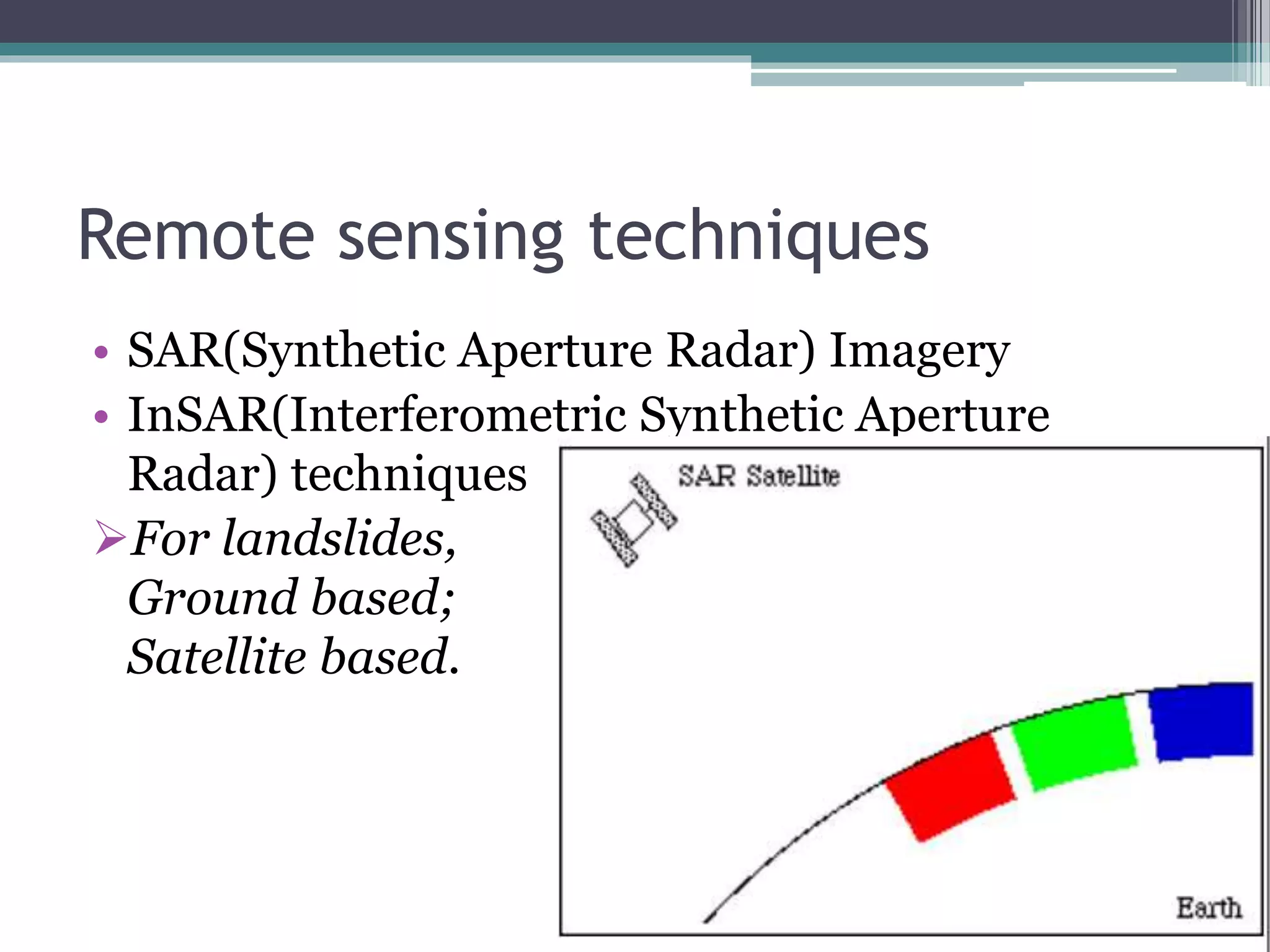
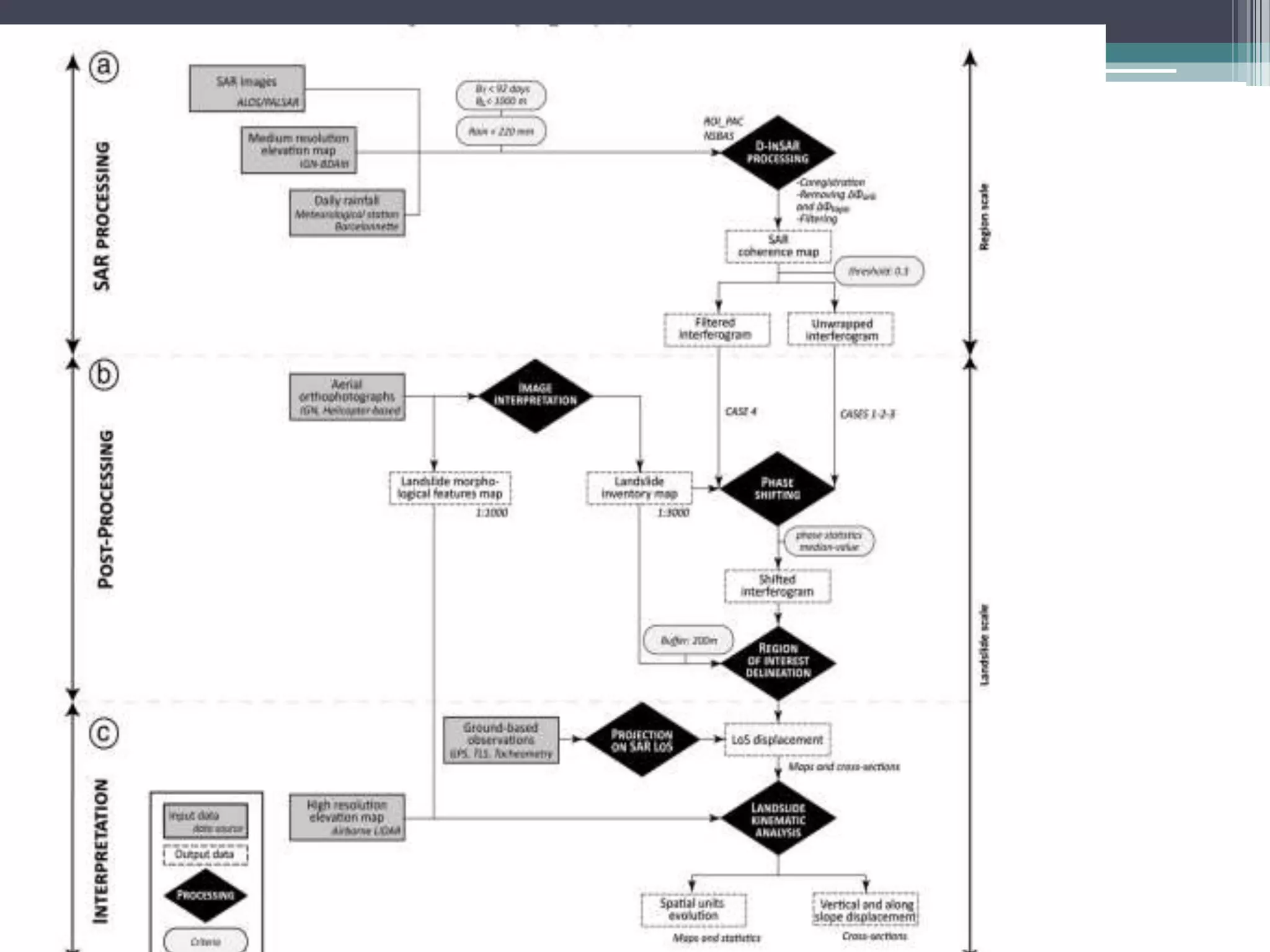
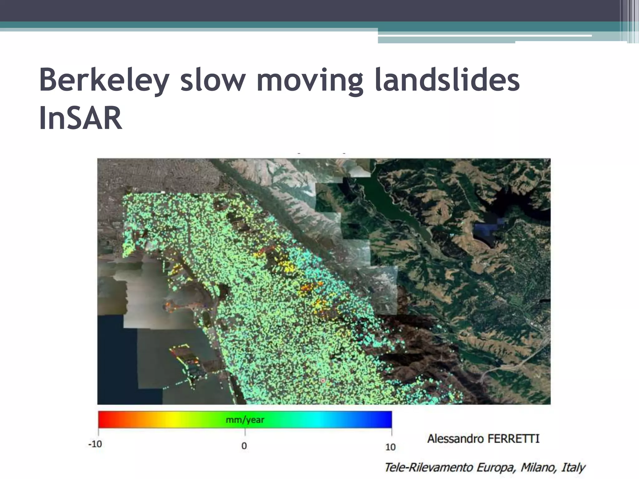
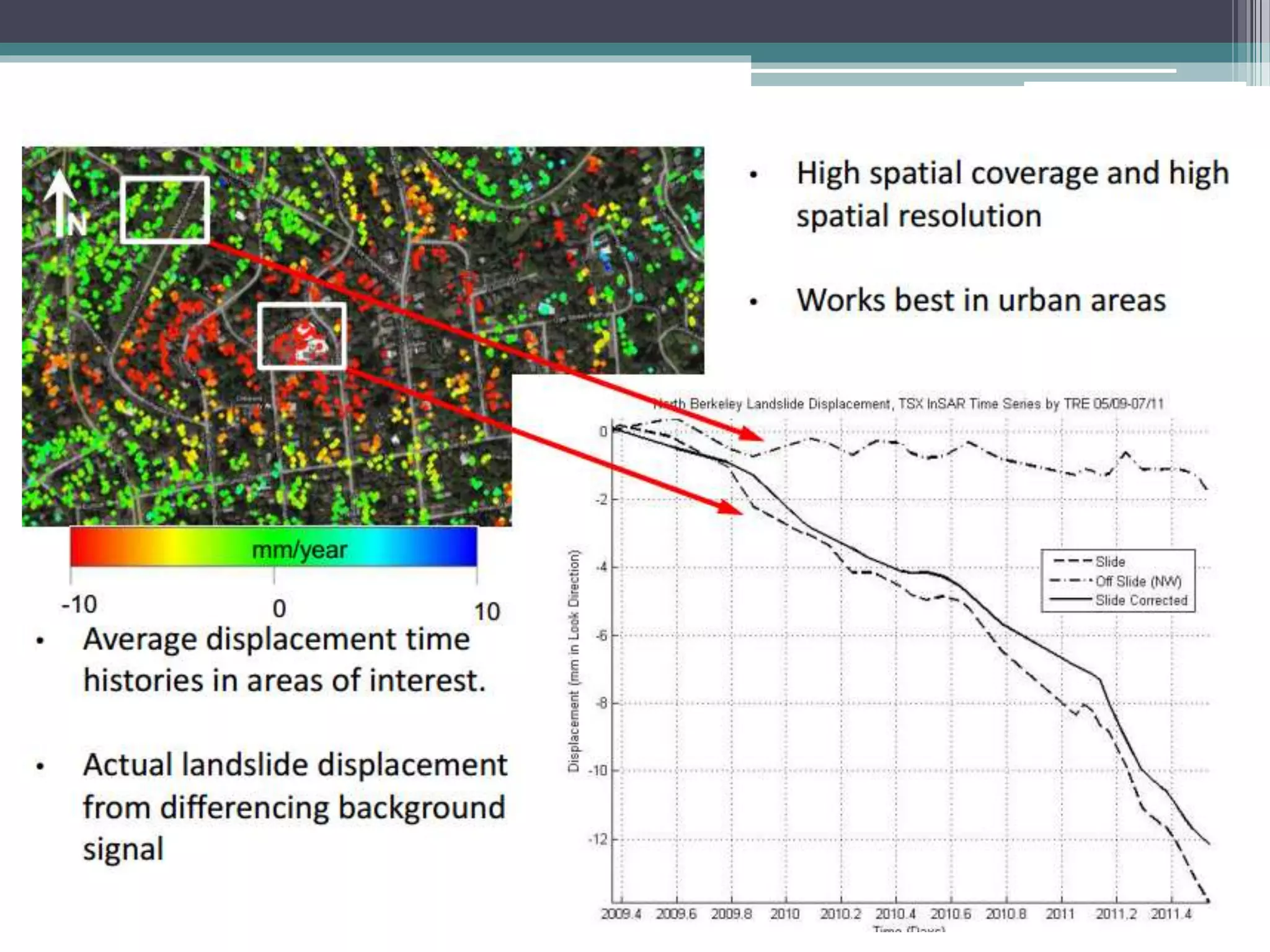
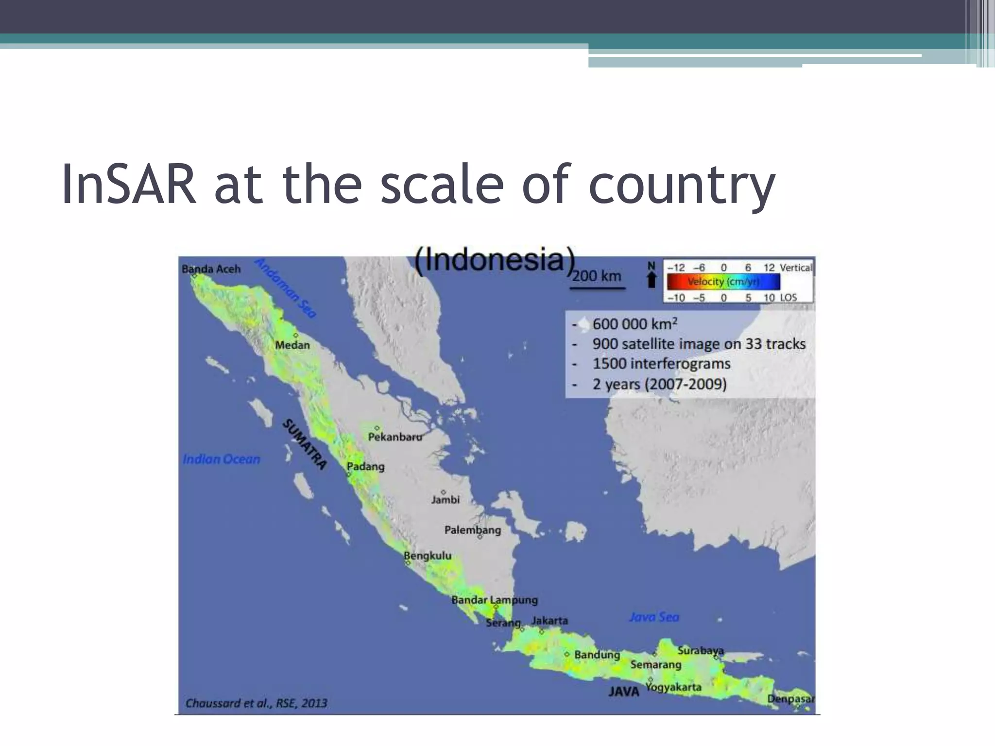
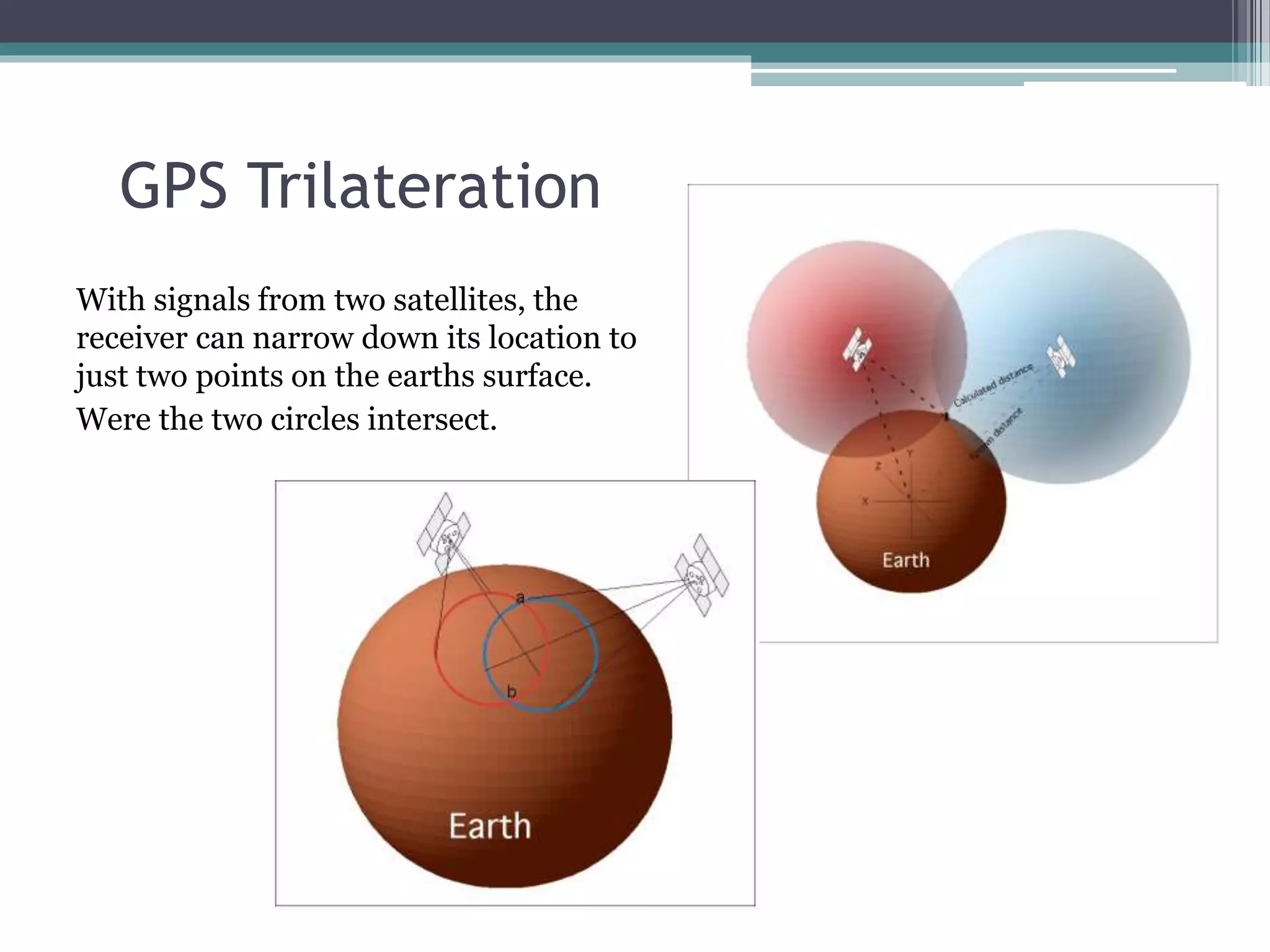
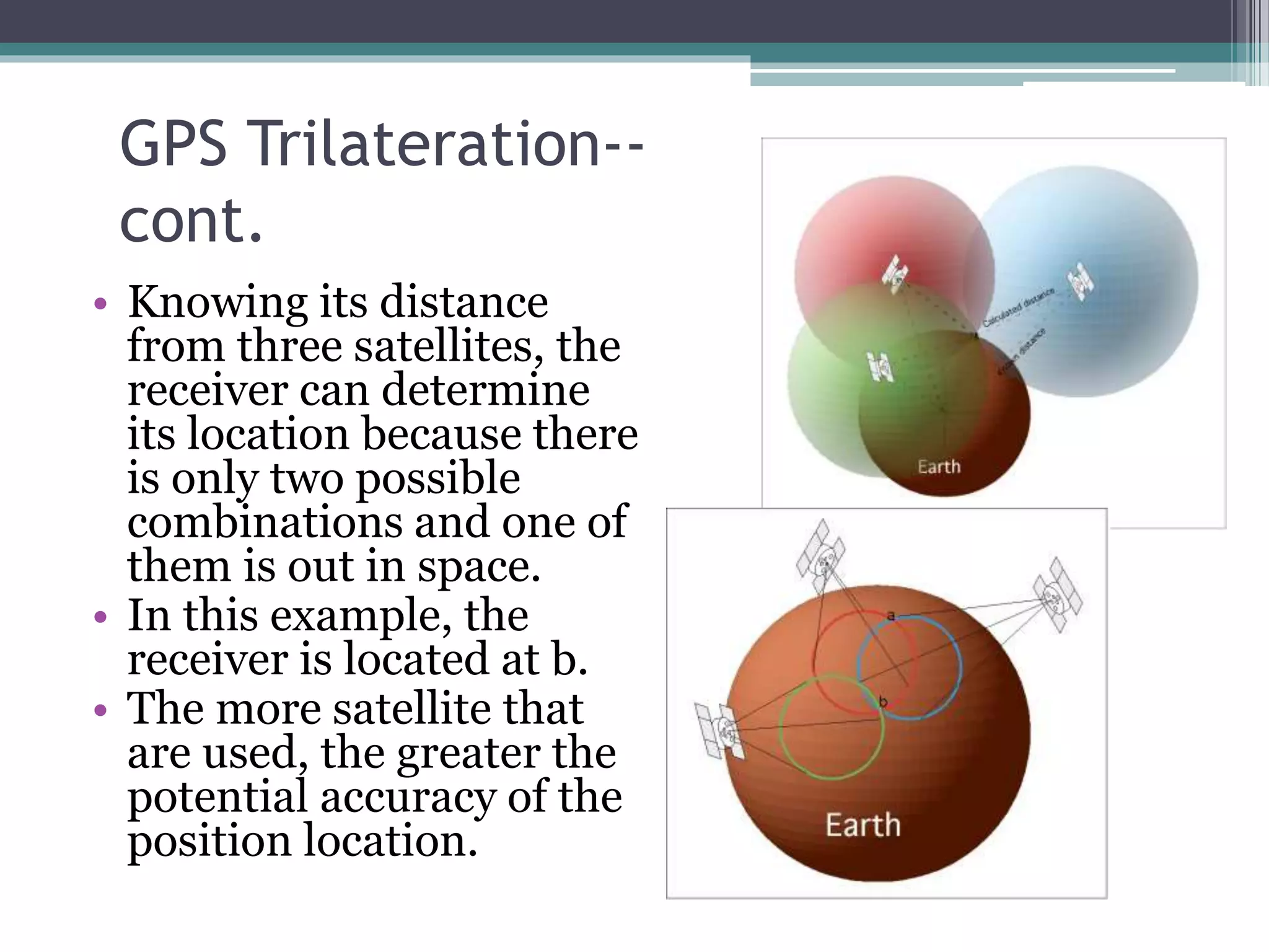
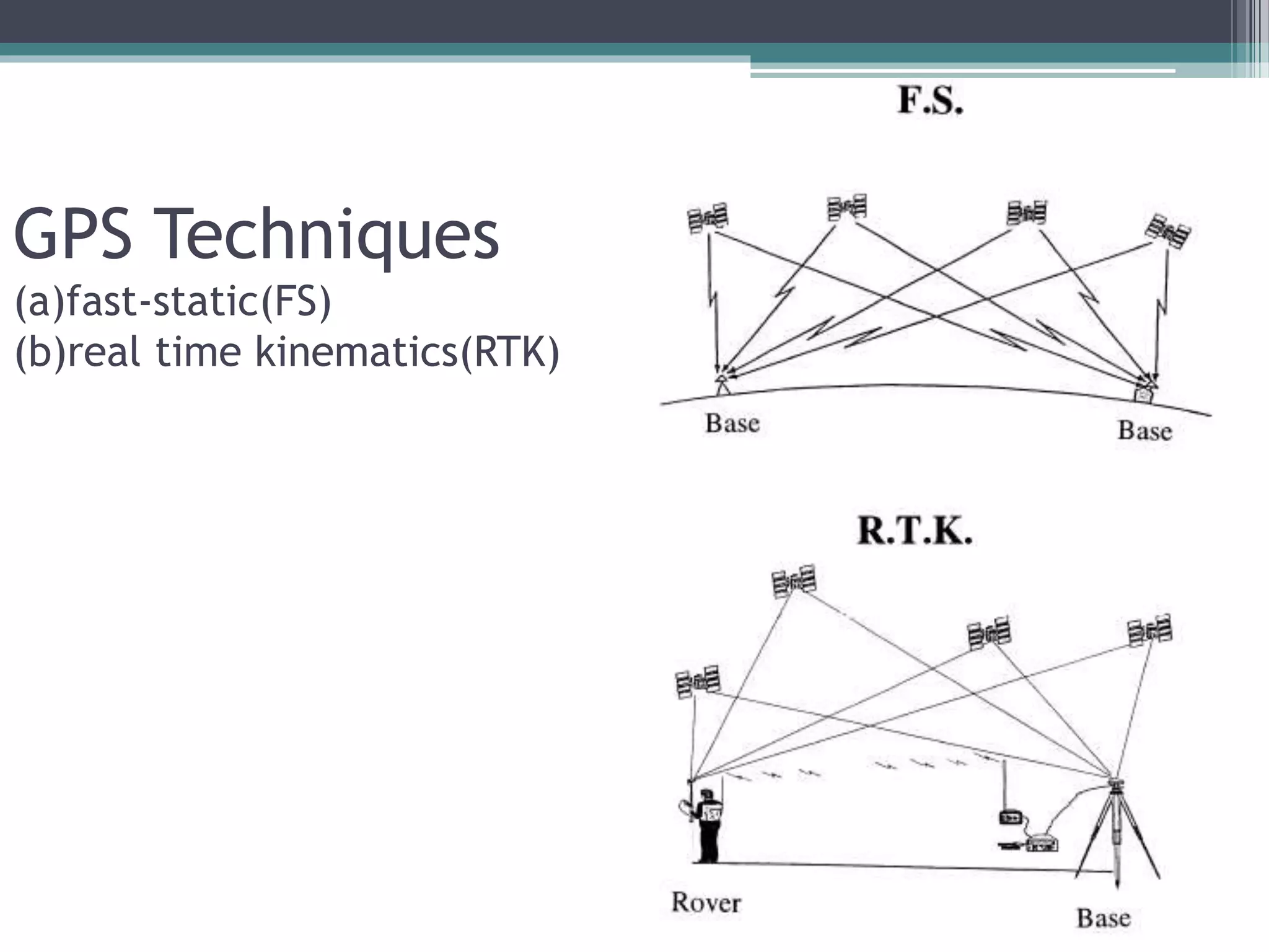
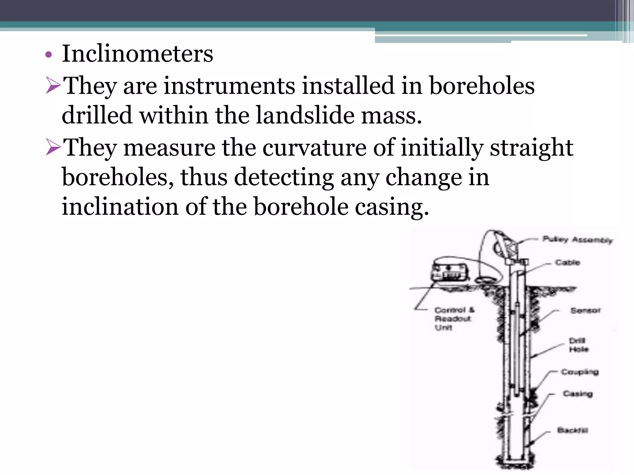
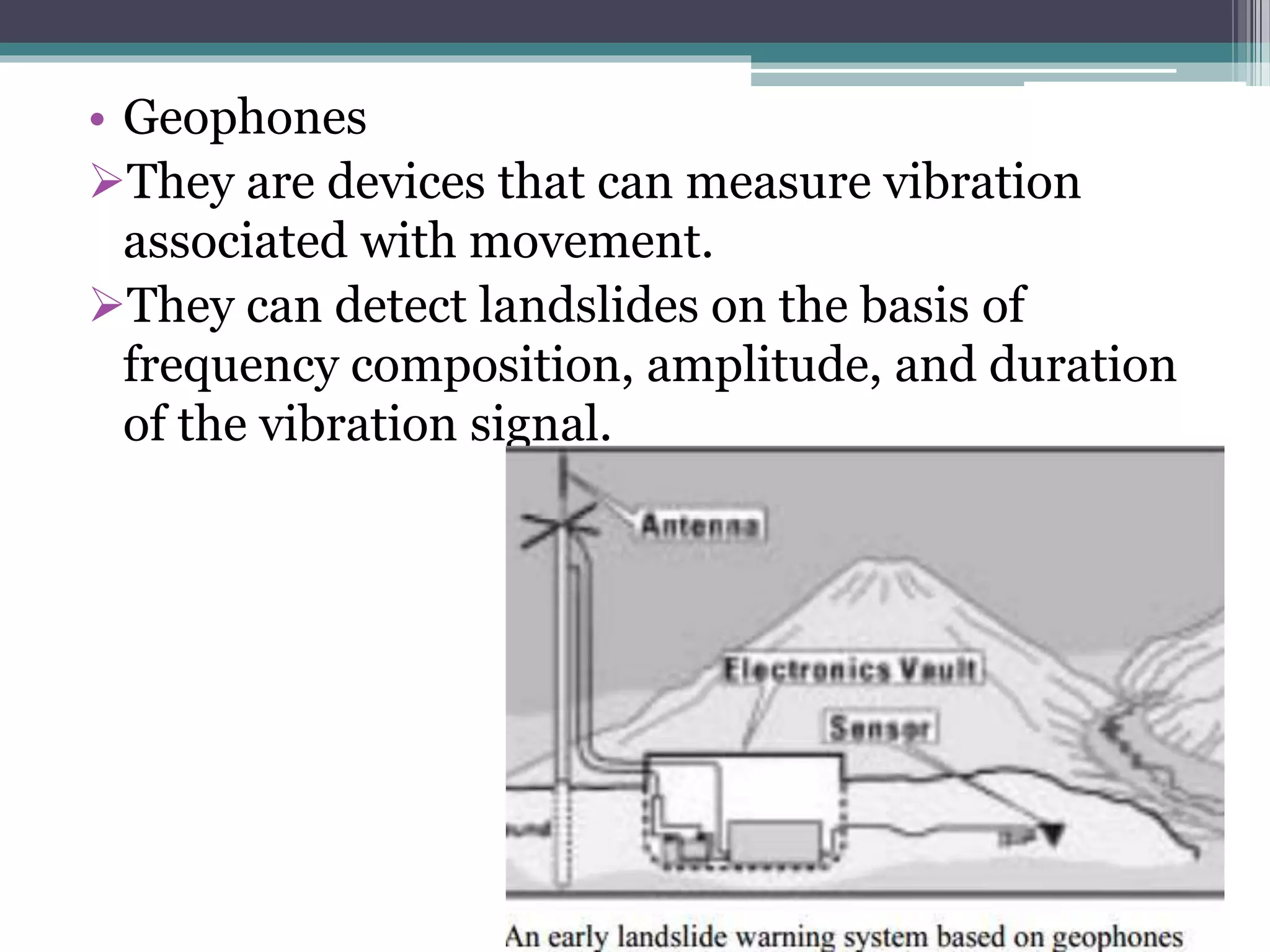
LANDSLIDE MONITORING
SYSTEMS & TECHNIQUES
MANEEB MASOOD
M.Tech.Part-1(15152010)
Introduction
• Landslides are downslope movements of rock,
debris or earth under the influence of gravity.
• Landslides are one of the most significant
hazards in terms of socio-economic costs,
threatening infrastructures and human
settlements.
• The monitoring of their surface displacement is
thus crucial for the prevention and forecast of
landslides.
Systems and Techniques for
Landslide Monitoring
• 1. Remote sensing or satellite techniques with
space-derived information.
• 2. Photogrammetric techniques
• 3. Ground-based conventional surveying
techniques
• 4. GPS techniques
• 5. Geotechnical techniques
Remote sensing techniques
• SAR(Synthetic Aperture Radar) Imagery
• InSAR(Interferometric Synthetic Aperture
Radar) techniques
For landslides,
Ground based;
Satellite based.
• RADAR (Radio Detection and Ranging)
Satellite sends a pulse of electromagnetic energy into space
that reflects upon encountering the Earth surface.
(A radar transmits radio waves or microwaves that reflect from any object in
their path. A receive radar, which is typically the same system as the transmit
radar, receives and proesses these reflected waves to determine properties of
the objects)
• SAR (Synthetic Aperture RADAR)
Larger antenna = better resolution -> SAR uses the spacecraft
motion to simulate an extremely long antenna.
• Interferometric
Difference 2 phase images of the same area at different times
to detect ground motion = interferogram.
Combine many interferograms to produce amean velocity map
in which the color shows the speed at which the ground is
moving.
InSAR (Interferometric Synthetic Aperture RADAR)
Berkeley slow moving landslides
InSAR
InSAR at the scale of country
Photogrammetric techniques for
landslide monitoring
• The interpretation of aerial photography has
proven to be an effective technique for
recognizing and delineating landslides.
• It is an effective technique for recognizing and
delineating 3D overview of the terrain from
which the interrelations of photography,
drainage, surface cover, geology materials, and
human activities on the landscape can be viewed
and evaluated.
Ground-based conventional surveying
techniques for landslide monitoring
• Triangulation
• Levelling
• Monitoring by Total Stations
Using Global Positioning System
techniques in landslide monitoring
• GPS provides specially coded satellite signals that
can be processed with a GPS receiver, enabling the
receiver to compute position, velocity and time.
• A minimum of four GPS satellite signals are
required to compute positions in three dimensions
and the time offset in the receiver clock.
• Accuracy and precision of data increases with more
satellites.
GPS Trilateration
With signals from two satellites, the
receiver can narrow down its location to
just two points on the earths surface.
Were the two circles intersect.
GPS Trilateration--
cont.
• Knowing its distance
from three satellites, the
receiver can determine
its location because there
is only two possible
combinations and one of
them is out in space.
• In this example, the
receiver is located at b.
• The more satellite that
are used, the greater the
potential accuracy of the
position location.
GPS Techniques
(a)fast-static(FS)
(b)real time kinematics(RTK)
Special considerations for monitoring
• The selected targets must reflect the mean
behaviour of the surrounding area.
• Tree canopy, buildings and other obstacles that
could restrict the reception of the satellite signal
should be avoided.
• To mark the station points, it is advisable to use
sturdy stations.
• It is convenient to include within the control
network several fixed points outside the landslide
area.
• To strengthen the results, it will also be helpful to
use different methods and repeat the observations.
Geotechnical techniques for landslide
monitoring
• Geotechnical sensors are used extensively in the
monitoring of structures.
• The main geotechnical sensors used for
deformation monitoring include; extensometers,
inclinometers, piezometers, strain meters,
pressure cells, geophones, tilt meters and crack
meters.
• Inclinometers
They are instruments installed in boreholes
drilled within the landslide mass.
They measure the curvature of initially straight
boreholes, thus detecting any change in
inclination of the borehole casing.
• Extensometers
Measure the axial displacement between a number
of reference points in the same measurements axis.
They can be installed within a borehole or on the
slope surface.
The wire extensometer is widely used typically
measuring baselines of up to 80 m in length with a
accuracy of ± 0.3 mm per 30 m.
The actual accuracy depends on the temperature
corrections and on the quality of the installation of
the extensometer.
Maintaining a constant tension throughout the use
of the wire extensometer is very important.
• Piezometers
Many landslides are triggered by slope saturation
following heavy rainfall.
Measurement of pore water pressures and
piezometric levels form an important part of
slope stability analysis.
Threshold levels can be defined to provide early
warning of conditions that may lead to
catastrophic failure.
• Geophones
They are devices that can measure vibration
associated with movement.
They can detect landslides on the basis of
frequency composition, amplitude, and duration
of the vibration signal.
References
• Using Global Positioning System techniquesin landslide monitoring
Josep A. Gili a,b,*, Jordi Corominas a, Joan Rius a Department of Geotechnical Engineering and
Geosciences, Technical University of Catalonia, Jordi Girona 1–3,Edifici D-2, 08034 Barcelona, Spain
b Institute of Geomatics, Barcelona, Spain
Received 24 November 1998; accepted for publication 8 July 1999
• Traditional and Innovative Techniques for Landslide Monitoring:
dissertation on design criteria Paolo Mazzanti1, Giorgio Pezzetti2
1NHAZCA S.r.l. & Department of Earth Sciences, Università di Roma “Sapienza”, Rome, Italy
2FIELD S.r.l. Bergamo, Italy
• Landslide monitoring with InSAR
E. Chaussard, R. Bü rgmann,
J. Cohen-Waeber, B. Delbridge (University of California Berkeley)
• Landslide deformation monitoring with ALOS/PALSAR imagery: A D-InSAR
geomorphological interpretation method Romy Schlögel ⁎, Cécile Doubre, Jean-Philippe Malet,
Frédéric Masson Institut de Physique du Globe de Strasbourg, CNRS UMR 7516, Université de
Strasbourg/EOST, 5 rue Descartes, 67084 Strasbourg, Cedex, France
• Landslide monitoring by combining of CR-InSAR and GPS techniques
Wu Zhu a,c,⇑, Qin Zhang a,b, XiaoLi Ding c, Chaoying Zhao a,b, Chengsheng Yang a,b,
Feifei Qu a, Wei Qu a,b
a College of Geology Engineering and Geomatics, Chang’an University, No. 126 Yanta Road, Xi’an 710054,
China. bKey Laboratory of Western China’s Mineral Resources and Geological Engineering, Ministry of
Education, No. 126 Yanta Road, Xi’an 710054, China
c Department of Land Surveying and Geo-Informatics, Hong Kong Polytechnic University, Hong Kong, China
Received 19 November 2012; received in revised form 21 November 2013; accepted 3 December 2013
Available online 10 December 2013

Landslide monitoring systems & techniques

  • 1.
    LANDSLIDE MONITORING SYSTEMS &TECHNIQUES MANEEB MASOOD M.Tech.Part-1(15152010)
  • 2.
    Introduction • Landslides aredownslope movements of rock, debris or earth under the influence of gravity. • Landslides are one of the most significant hazards in terms of socio-economic costs, threatening infrastructures and human settlements. • The monitoring of their surface displacement is thus crucial for the prevention and forecast of landslides.
  • 3.
    Systems and Techniquesfor Landslide Monitoring • 1. Remote sensing or satellite techniques with space-derived information. • 2. Photogrammetric techniques • 3. Ground-based conventional surveying techniques • 4. GPS techniques • 5. Geotechnical techniques
  • 4.
    Remote sensing techniques •SAR(Synthetic Aperture Radar) Imagery • InSAR(Interferometric Synthetic Aperture Radar) techniques For landslides, Ground based; Satellite based.
  • 5.
    • RADAR (RadioDetection and Ranging) Satellite sends a pulse of electromagnetic energy into space that reflects upon encountering the Earth surface. (A radar transmits radio waves or microwaves that reflect from any object in their path. A receive radar, which is typically the same system as the transmit radar, receives and proesses these reflected waves to determine properties of the objects) • SAR (Synthetic Aperture RADAR) Larger antenna = better resolution -> SAR uses the spacecraft motion to simulate an extremely long antenna. • Interferometric Difference 2 phase images of the same area at different times to detect ground motion = interferogram. Combine many interferograms to produce amean velocity map in which the color shows the speed at which the ground is moving. InSAR (Interferometric Synthetic Aperture RADAR)
  • 7.
    Berkeley slow movinglandslides InSAR
  • 9.
    InSAR at thescale of country
  • 10.
    Photogrammetric techniques for landslidemonitoring • The interpretation of aerial photography has proven to be an effective technique for recognizing and delineating landslides. • It is an effective technique for recognizing and delineating 3D overview of the terrain from which the interrelations of photography, drainage, surface cover, geology materials, and human activities on the landscape can be viewed and evaluated.
  • 11.
    Ground-based conventional surveying techniquesfor landslide monitoring • Triangulation • Levelling • Monitoring by Total Stations
  • 12.
    Using Global PositioningSystem techniques in landslide monitoring • GPS provides specially coded satellite signals that can be processed with a GPS receiver, enabling the receiver to compute position, velocity and time. • A minimum of four GPS satellite signals are required to compute positions in three dimensions and the time offset in the receiver clock. • Accuracy and precision of data increases with more satellites.
  • 13.
    GPS Trilateration With signalsfrom two satellites, the receiver can narrow down its location to just two points on the earths surface. Were the two circles intersect.
  • 14.
    GPS Trilateration-- cont. • Knowingits distance from three satellites, the receiver can determine its location because there is only two possible combinations and one of them is out in space. • In this example, the receiver is located at b. • The more satellite that are used, the greater the potential accuracy of the position location.
  • 15.
  • 16.
    Special considerations formonitoring • The selected targets must reflect the mean behaviour of the surrounding area. • Tree canopy, buildings and other obstacles that could restrict the reception of the satellite signal should be avoided. • To mark the station points, it is advisable to use sturdy stations. • It is convenient to include within the control network several fixed points outside the landslide area. • To strengthen the results, it will also be helpful to use different methods and repeat the observations.
  • 17.
    Geotechnical techniques forlandslide monitoring • Geotechnical sensors are used extensively in the monitoring of structures. • The main geotechnical sensors used for deformation monitoring include; extensometers, inclinometers, piezometers, strain meters, pressure cells, geophones, tilt meters and crack meters.
  • 18.
    • Inclinometers They areinstruments installed in boreholes drilled within the landslide mass. They measure the curvature of initially straight boreholes, thus detecting any change in inclination of the borehole casing.
  • 19.
    • Extensometers Measure theaxial displacement between a number of reference points in the same measurements axis. They can be installed within a borehole or on the slope surface. The wire extensometer is widely used typically measuring baselines of up to 80 m in length with a accuracy of ± 0.3 mm per 30 m. The actual accuracy depends on the temperature corrections and on the quality of the installation of the extensometer. Maintaining a constant tension throughout the use of the wire extensometer is very important.
  • 20.
    • Piezometers Many landslidesare triggered by slope saturation following heavy rainfall. Measurement of pore water pressures and piezometric levels form an important part of slope stability analysis. Threshold levels can be defined to provide early warning of conditions that may lead to catastrophic failure.
  • 21.
    • Geophones They aredevices that can measure vibration associated with movement. They can detect landslides on the basis of frequency composition, amplitude, and duration of the vibration signal.
  • 22.
    References • Using GlobalPositioning System techniquesin landslide monitoring Josep A. Gili a,b,*, Jordi Corominas a, Joan Rius a Department of Geotechnical Engineering and Geosciences, Technical University of Catalonia, Jordi Girona 1–3,Edifici D-2, 08034 Barcelona, Spain b Institute of Geomatics, Barcelona, Spain Received 24 November 1998; accepted for publication 8 July 1999 • Traditional and Innovative Techniques for Landslide Monitoring: dissertation on design criteria Paolo Mazzanti1, Giorgio Pezzetti2 1NHAZCA S.r.l. & Department of Earth Sciences, Università di Roma “Sapienza”, Rome, Italy 2FIELD S.r.l. Bergamo, Italy • Landslide monitoring with InSAR E. Chaussard, R. Bü rgmann, J. Cohen-Waeber, B. Delbridge (University of California Berkeley) • Landslide deformation monitoring with ALOS/PALSAR imagery: A D-InSAR geomorphological interpretation method Romy Schlögel ⁎, Cécile Doubre, Jean-Philippe Malet, Frédéric Masson Institut de Physique du Globe de Strasbourg, CNRS UMR 7516, Université de Strasbourg/EOST, 5 rue Descartes, 67084 Strasbourg, Cedex, France • Landslide monitoring by combining of CR-InSAR and GPS techniques Wu Zhu a,c,⇑, Qin Zhang a,b, XiaoLi Ding c, Chaoying Zhao a,b, Chengsheng Yang a,b, Feifei Qu a, Wei Qu a,b a College of Geology Engineering and Geomatics, Chang’an University, No. 126 Yanta Road, Xi’an 710054, China. bKey Laboratory of Western China’s Mineral Resources and Geological Engineering, Ministry of Education, No. 126 Yanta Road, Xi’an 710054, China c Department of Land Surveying and Geo-Informatics, Hong Kong Polytechnic University, Hong Kong, China Received 19 November 2012; received in revised form 21 November 2013; accepted 3 December 2013 Available online 10 December 2013