This document analyzes stereoscopic 3D geological mapping methods using Cardinal and Esri software systems. It discusses how the Utah Geological Survey and some colleges use the VrOne and VrTwo 3D software from Cardinal Systems to explore, map, and edit areas of geological interest in stereoscopic 3D. This allows for unique observation of elevation and features. The maps are then digitized in 3D, edited, and finished in ArcMap to create 2D geological maps. These maps are field checked and compared to other maps created through different methods to evaluate their accuracy and precision. The document outlines the procedures, field and editing methods, and results of using the Cardinal 3D system for mapping, including both benefits like extensive pre-
This PPT gives a brief description about Geomatics, the disciplines and techniques constituting Geomatics, Geographic Information System or GIS, GIS data (Spatial Data and Non- Spatial Data), GIS data models, GIS application in Petroleum Exploration, Coordinate System, Geodetic Datum and ArcGIS.
The PPT was used for the presentation of the GIS application for defense purpose and the satellites used by the INA (Indian National Army), INAF (Indian Navy Armed Forces) and the IAF (Indian Air Force).
Role of GIS in Health Care Management by Dr. Dipti MukherjiPriyanka_vshukla
Presentation on Role of GIS in Health Care Management by Dr. Dipti Mukherji during Seminar on Spatial Dimensions on Health Care - Use of GIS in Health Studies Organised by CEHAT and University of Mumbai on 24th Sep 2010
Geographic Information Systems (GIS) play a pivotal role in military operations. The concept of Command, Control, Communication and Coordination in military operations is largely dependent on the availability of accurate, spatial information to arrive at quick decisions for operational orders.
In the present digital era, GIS is an excellent tool for military commanders in the operations. The use of GIS applications in military forces has revolutionised the way in which these forces operate and function.
GIS and Remote Sensing Training at Pitney Bowes SoftwareNishant Sinha
This presentation was made for internal training in Pitney Bowes. The content has many references across and has not been compiled. A simple ppt will help a lot.
Topics:
1. Mapping Concepts
2. Analysis with paper based Maps
3. Limitations of Paper based Maps
4. Computer Aided Cartography History and Development
5. GIS Definition
6. Advantage of Digital Maps
Object Classification of Satellite Images Using Cluster Repulsion Based Kerne...IOSR Journals
Abstract: We investigated the Classification of satellite images and multispectral remote sensing data .we
focused on uncertainty analysis in the produced land-cover maps .we proposed an efficient technique for
classifying the multispectral satellite images using Support Vector Machine (SVM) into road area, building area
and green area. We carried out classification in three modules namely (a) Preprocessing using Gaussian
filtering and conversion from conversion of RGB to Lab color space image (b) object segmentation using
proposed Cluster repulsion based kernel Fuzzy C- Means (FCM) and (c) classification using one-to-many SVM
classifier. The goal of this research is to provide the efficiency in classification of satellite images using the
object-based image analysis. The proposed work is evaluated using the satellite images and the accuracy of the
proposed work is compared to FCM based classification. The results showed that the proposed technique has
achieved better results reaching an accuracy of 79%, 84%, 81% and 97.9% for road, tree, building and vehicle
classification respectively.
Keywords:-Satellite image, FCM Clustering, Classification, SVM classifier.
International Journal of Computational Engineering Research (IJCER) is dedicated to protecting personal information and will make every reasonable effort to handle collected information appropriately. All information collected, as well as related requests, will be handled as carefully and efficiently as possible in accordance with IJCER standards for integrity and objectivity.
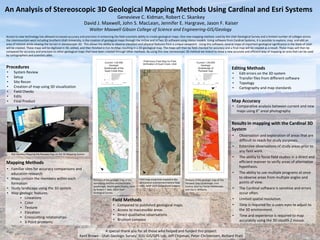
1. An Analysis of Stereoscopic 3D Geological Mapping Methods Using Cardinal and Esri Systems
Genevieve C. Kidman, Robert C. Skankey
David J. Maxwell, John S. MacLean, Jennifer E. Hargrave, Jason F. Kaiser
Walter Maxwell Gibson College of Science and Engineering-GIS/Geology
Access to new technology has allowed increased accuracy and precision in enhancing the field scientists ability to create geological maps. One new mapping method, used by the Utah Geological Survey and a limited number of colleges across
the intermountain west including Southern Utah University, is the creation of geological maps through the VrOne and VrTwo 3D software using stereo models. Using software from Cardinal Systems, it is possible to explore, map, and edit an
area of interest while viewing the terrain in stereoscopic 3D. This allows the ability to observe elevation and physical features from a unique viewpoint. Using this software, several maps of important geological significance in the State of Utah
will be created. These maps will be digitized in 3D, edited, and then finished in Esri ArcMap resulting in a 2D geological map. The maps will then be field checked for accuracy and a final map will be created as a result. These maps will then be
compared for accuracy and precision to other geological maps that have been created through other methods. By using this new stereoscopic 3D method we intend to show a new accurate and efficient way of mapping an area that can be used
by cartographers and scientists alike.
Procedures
• System Review
• Setup
• Site Recon
• Creation of map using 3D visualization
• Field Checks
• Edits
• Final Product
Field Methods
• Compared to published geological maps.
• Access to inaccessible areas
• Direct qualitative observations
• Brunton compass
Editing Methods
• Edit errors on the 3D system
• Transfer files from different software
• Topology
• Cartography and map standards
Map Accuracy
• Comparative analysis between current and new
maps using 6” areal photography
Results in mapping with the Cardinal 3D
System
• Observation and exploration of areas that are
difficult to reach for study purposes.
• Extensive observations of study areas prior to
any field work.
• The ability to focus field studies in a direct and
efficient manner to verify areas of alternative
hypothesis.
• The ability to use multiple programs at once
to observe areas from multiple angles and
points of view.
• The Cardinal software is sensitive and errors
occur often.
• Limited spatial resolution.
• Time is required for a users eyes to adjust to
the 3D environment.
• Time and experience is required to map
accurately using the 3D stealth Z mouse.
A special thank you for all those who helped and funded this project:
Kent Brown - Utah Geologic Survey, SUU GIS/GPS Lab, Jeff Chipman, Peter Christensen, Richard Pratt
Mapping Methods
• Familiar sites for accuracy comparisons and
education research
• Maps contain the members within each
formation
• Study landscape using the 3D system
• Map geologic features
▪ Lineations
▪ Color
▪ Texture
▪ Elevation
▪ Crosscutting relationships
▪ 3-Point problems
Rob Skankey Mapping the Parowan Gap on the 3D Mapping System
Portions of the geologic map of the
Harrisburg Junction and Hurricane
quadrangle, Washington County, Utah
by Robert F. Biek, 2003 Utah
Geological Survey
Field map using lines created in the
3D Cardinal environment before final
edits. NAIP 2014 Background imagery
Portions of the geologic map of The
Parowan Gap Quadrangle, Iron
Coutny Utah by Florian Maldonado
and Van S. Williams.