The Fezzan region of southwest Libya has a long history of human settlement dating back to prehistoric times, as evidenced by archaeological remains found around ancient lake deposits. The region was much wetter in the past, containing a vast inland lake over 120,000 square kilometers during humid periods when rainfall was higher. As the climate became more arid, the lake shrank and split into smaller lakes around which human occupation concentrated. The Garamantes civilization developed in the region between 2,400-1,800 years ago, introducing oasis agriculture. Today the region has potential for tourism development and renewable energy but fragile environments need protection.
The following set of slides were used by Chris McLindon in a presentation given to the New Orleans American Planning Association on August 31st, 2016. The presentation was made on behalf of the New Orleans Geological Society as part of an informal public outreach effort. You may reach Chris McLindon at chris_mclindon@att.net
Geotechnical Properties of Sabkha Soil in the southern part of Al-Khobar city...IJERA Editor
The geotechnical properties of sabkha soil covering most parts of the southern portion of Al-Khobar area –Saudia Arabia were determined. These soil have very low strength, low bearing capacity and high compressibility. The expected settlement is always above the recommended tolerable limits. The chemical analysis of both soil and water from sabkha flat shows a very high concentration of salts. These high concentrations of salts give rise to a very corrosive environment and therefore it is recommended to protect concrete and reinforcement by using sulphate resisting cement, pozzolanic materials, use of corrosion inhibitors and by applying suitable water proofing membranes . The properties determined during this study has a significant impact on both technical and economical values of each project and therefore, the outcome of the study is much important for planners and developers .
After attending this lesson, the user would be able to understand the basic characteristics of the submarine canyons, their origin, and their distribution in various major oceans of the world.
Detailed information about the morphological conditions, sedimentology and marine life of the submarine canyons will also be understood.
Ancient hydrothermal seafloor deposits in Eridania basin on MarsSérgio Sacani
The Eridania region in the southern highlands of Mars once contained a vast inland sea with a
volume of water greater than that of all other Martian lakes combined. Here we show that the
most ancient materials within Eridania are thick (4400 m), massive (not bedded), mottled
deposits containing saponite, talc-saponite, Fe-rich mica (for example, glauconite-nontronite),
Fe- and Mg-serpentine, Mg-Fe-Ca-carbonate and probable Fe-sulphide that likely
formed in a deep water (500–1,500 m) hydrothermal setting. The Eridania basin occurs
within some of the most ancient terrain on Mars where striking evidence for remnant
magnetism might suggest an early phase of crustal spreading. The relatively well-preserved
seafloor hydrothermal deposits in Eridania are contemporaneous with the earliest evidence
for life on Earth in potentially similar environments 3.8 billion years ago, and might provide
an invaluable window into the environmental conditions of early Earth.
The Pleistocene Delta of the Old Al Balatah River System, Northeastern Libya ...ijtsrd
The present article concerns with the topography, geomorphology and morphotectonic features of the vast Pleistocene inland delta of the paleoriver system of the Al Balatah Valley in northeastern Libya and its eastern extension in the Great Sand Sea of Egypt where it constitutes what is known as Nahda Plain immediately east of the Libyan Egyptian borders. The paleodelta was formed as a result of northward flowing of the old Al Balatah river streams into a huge Pleistocene freshwater lake occupying the area lying between latitudes 26° 30’ and 28° 30’, and longitudes 23° 15 and 25° 26’. It was previously described as belonging to the ancient Al Kufrah Paleoriver, however, evidences from the paleo drainage patterns show that this ancient delta is belonging to the Al Balatah Paleoriver, not to the Al Kufrah Paleoriver. The paleoriver basin of the Al Balatah Valley is bounded along its both eastern Egyptian and western Libyan sides by two intersecting groups of structurally controlled Nubia Sandstone landforms. The older group is made up of a parallel series of longitudinal ridges trending NW SE and representing bended up folded , cross bedded to horizontally Nubia Sandstone layers separated by low lying down folded tracks formed as a result of the Upper Cretaceous Turonian folding movement which affected the Western Desert of Egypt and Eastern Desert of Libya. The younger group is extending NE SW and consisting of a parallel series of huge mountain ranges of Nubia Sandstone made up of new plateaus depressions and dome like structures troughs formed as a result of the Late Oligocene refolding movement and dissecting the older Nubia Sandstone ridges. The results are fundamentally significant to the establishment of new agricultural communities in the inhospitable place known as the Great Sand Sea along both sides of the Egyptian Libyan borders especially when considering the threat of fresh water scarcity in both countries. Khaled Abdel-Kader Ouda "The Pleistocene Delta of the Old Al Balatah River System, Northeastern Libya and its Eastern Extension in Egypt" Published in International Journal of Trend in Scientific Research and Development (ijtsrd), ISSN: 2456-6470, Volume-8 | Issue-1 , February 2024, URL: https://www.ijtsrd.com/papers/ijtsrd63511.pdf Paper Url: https://www.ijtsrd.com/other-scientific-research-area/geology/63511/the-pleistocene-delta-of-the-old-al-balatah-river-system-northeastern-libya-and-its-eastern-extension-in-egypt/khaled-abdelkader-ouda
The Nubian Sandstone Aquifer and the Debates About its RenewabilityHassan Yahya
The Nubian Sandstone Aquifer is one of the largest groundwater basins in the world and it was the subject for a lot of studies since 1920s. The aim of this paper is to give the reader a brief background about this aquifer and to discuss the debate about its renewability. The report discussed the aquifer and its renewability using supportive details and demonstrated it by the aid of graphics, analysis and recommendations of different well-known specialists and scientists in the field.
The River Nile delta shallow lakes namely, Edku, Burullus and Manzala are natural wetland ecosystems, connected to fresh water sources at the south and to the open sea at the north. Throughout their relatively short geological and hydrological history, the lakes received unpolluted fresh water from the river Nile.
Introduction, Models, Types of estuaries on the basis of origin; Salinity condition or freshwater discharge; Circulation; Estuaries in India; Estuaries as ecosystem; Why are estuaries important; Threats ;How can we help to protect them; Conclusion.
Ras Muhammad Marine National Park is located on faulted and uplifted Neogene blocks that are
partially covered by Quaternary limestones of predominantly coralgal facies. The physiography of the
reefal limestone cropping out in the area and also the present-day depositional environments are
tectonically controlled. Surface morphology observations show that earthquake pools that cut through the
uplifted Pleistocene reefs indicate continuing recent movements, as indicated by numerous records of
seismic activity in the study area. The morphostructural-generated depositional facies patterns on the
peninsula are a wide tidal belt with tidal shoals and coastal spits, barrier and fringing reefs, three
elongated embayments, Hiddan Bay, mangrove and tidal channels, Ras Muhammad pool and sabkha, and
earthquake pools (two earth fissures). The distribution of marine plants is described for each area. The
abundance of algae in Ras Muhammad appeared to be inversely related to the abundance of living corals.
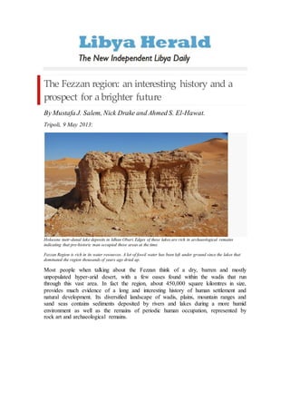
1. The Fezzan region: an interesting history and a
prospect for a brighter future
By Mustafa J. Salem, Nick Drake and Ahmed S. El-Hawat.
Tripoli, 9 May 2013:
Holocene inetr-dunal lake deposits in Idhan Obari. Edges of these lakes are rich in archaeological remains
indicating that pre-historic man occupied these areas at the time.
Fezzan Region is rich in its water resources. A lot of fossil water has been left under ground since the lakes that
dominated the region thousands of years ago dried up.
Most people when talking about the Fezzan think of a dry, barren and mostly
unpopulated hyper-arid desert, with a few oases found within the wadis that run
through this vast area. In fact the region, about 450,000 square kilomtres in size,
provides much evidence of a long and interesting history of human settlement and
natural development. Its diversified landscape of wadis, plains, mountain ranges and
sand seas contains sediments deposited by rivers and lakes during a more humid
environment as well as the remains of periodic human occupation, represented by
rock art and archaeological remains.
2. Figure 1: During the Miocene period, the Fezzan Region was drained by few major rivers: Wadi ash
Shati, Wadi Ajal (Al-Hayat) and Wadi Nashu, forming the Nashu River System. The other river system
is Wadi Barjuj. Al these rivers and the other rivers of Sahabi River System and Serir Tibisti Rivers run
into the Mediterranean coast at the Gulf of Sirte ( Figure after N. Drake et al., Fezzan Mega - Lake
Project, 2007)
The Fezzan is a large topographic basin covering much of south-western Libya
that in past humid periods has contained a vast lake reaching a maximum size
of 120,000 square kilometres. The basin is bounded by the Al-Hamadah Al-
Hamra plateau to the north, the Jabal Al-Sawda and Al-Haruj Al-Aswad
shield volcanoes to the east, the Hamadat Mangueni to the south and the
Akakus Mountains to the west.
Interpretation of the topography and geology of the Fezzan Basin suggests
that its development was largely controlled by the interplay of volcanic and
fluvial activity.
Its origin appears to lie in the late Miocene period when the region that now
forms the basin contained a small river in the south called Wadi Barjuj and a
large river system further north named the River Nashu and composed of
channels, with tributaries that include Wadi al Ajal (Al Hayat), and Wadi ash
Shatti (See Fig.1).
Both these rivers ran from west to east-northeast emptying their loads in the
Mediterranean Sea at Gulf of Sirte. Another major river system called the
Sahabi River ran through the central and eastern Libya fed by branches
issuing from the Tibesti mountains and Kufra region to the south and also
terminating in the Gulf of Sirte (Fig. 1).
3. Figure 2: All the tributaries of River Nashu were gradually cut off by the Haruj Al-Aswad and its
expansion towards Jabal Al-Sawda in the Late Miocene or Early Messinian periods. Wadi Barjuj was
blocked by the growth of Al-Haruj Al-Aswad and Haruj Al-Abyad sometime between 4 and 2 MA
(Figure after N. Drake et al., Fezzan Mega- Lake Project, 2007) .
These rivers started to be affected by volcanic activity on the east of the basin
with the development of Jabal Al-Sawda from 12.3 to 8.0 million years ago
(MA) and Al-Haruj volcanic shield from 6.0 to 4.0 MA. As these volcanoes
grew they first cut off Wadi Nashu and then eventually Wadi Barjuj. The result
of these two events was a large closed basin in the Fezzan (Fig.2) (~350,000
square kilometres) that could sustain a very large lake during humid periods
(Fig 3).
Figure 3: Lake Mega-Fezzan reached an area of about 120,000km2 during the humid periods, after
the basin has been blocked by the volcanic fields in the east. (Red, volcanic fields, blue old lakes,
yellow sand seas) ( Figure after N. Drake et al., Fezzan Mega-Lake Project, 2007) .
4. Figure 4: Examined sediments consistof lacustrine limestone deposited in humid periods (top ledge),
inter-bedded with Aeolian sands deposited in arid periods (bottom softsediments).Similar deposits are
scattered in the area of Wadi ash Shati, Wadi Barjuj and Wadi Nashu.
Large areas of exposed sedimentary rocks in the area of the proposed lake are
the evidence for its existence. The sediments consist of lacustrine limestone
deposited in humid periods inter-bedded with Aeolian sands deposited in arid
periods(Fig.4) .
The earliest deposits examined are Pliocene in age. Humid periods appear to
correspond to interglacials and aridity is found in glacials.
It is possible that, from about 120,000 years ago (ka), water availability was
more restricted during interglacial humid periods than previously, leading to
the development of many small lakes in the Fezzan Basin, rather than the
single giant lake that had existed between about 200 and 420 ka. Sediments
indicating these small lakes are currently exposed in the inter-dune areas,
between the sand dunes of Idhan Murzuk and Idhan Obari (Figs 5 and 6).
These small inter-dune lakes in Idhan Obari and Idhan Murzuk attracted the
prehistoric hunters and animal herders and on their edges are found
archaeological and faunal remains (Figs 7 ,8 and 9). As these lakes finally
dried up between five and three thousand years ago, human occupation
concentrated around the few remaining springs and in these regions, villages
and small towns developed, one called Germa (Jarmah) eventually formed the
capital of the Garamantean civilization that flourished in the region between
2,400 and 1,800 years ago by introducing a diverse oasis agriculture and
establishing and controlling trans-Saharan trade.
5. Figure 5: Inter-dune lake with white lacustrine limestone deposits, probably Pleistocene-Holocene in
age.
Figure 6: Small inter-dune lake of Holocene age, in Idhan Obari , with a bed rich in organic material
(dark colour bed in the front ).
Figure 7: White limestone lake deposit with common fresh-water snails.
6. Figure 8: Inter-dune lake deposits in Idhan Murzuq with fresh water fish skeleton (Photo: courtesy of
Total Libya).
Figure 9: Palaeolithic rock tools scattered around the inter-dune lakes, Idhan Murzuk.
Prospects for the Fezzan Region in future
The Fezzan Region not only has a diversified landscape, but is also rich in
natural resources such as fossil fuels, renewable solar and wind energy for the
future, metallic and non-metallic minerals and above all, abundant
groundwater resources provided by its more humid past. Though the aquifers
contain fossil water, the low population in the Fezzan means that there should
be enough water resources for the region for some time to come if the resource
is well managed (Figs 10 and 11).
The diverse landscape of this region and its rich history makes it one of the
primary sites in Libya in terms of tourism potential. This can be achieved only
if the Ministry of Tourism collaborates with other concerned government
organisations and if it adopts a policy that aims at developing the Fezzan as an
area for cultural as well as adventure tourism. However, the fragile
environment means that this needs to be done in conjunction with the
development and implementation of policies on environmental sustainability
and conservation of the heritage.
7. Promotion of eco-tourism should be adopted as a priority alongside
conservation of fragile areas such as Akakus Mountains, Messak Settafet,
Idhan Murzuk, Wadi Aramat, the Meghidet region and the lakes of Idhan
Obari. Ideally these regions need to be protected by law, and restricted for
guided tours only. Large convoys of vehicles, such as those used for off-road
rallies should be restricted or prohibited. When planning conservation and
preservation programmes for the region the relevant authorities (the Ministry
of Tourism, Ministry of Culture, General Authority of Environment and the
Department of Antiquities) could benefit from the experience of other
countries with similar situations. A good example in Africa is Namibia with its
national conservation programs and those of the Namib Desert in particular.
Figure 10: Fezzan Region has enough water for agriculture. Though most of the water tapped from
fossil water aquifers, but with the proper management the water should be enough for some time to
come. A lot of precious water could be saved if the Irrigation system in this farm (Wadi Atabah) is
improved by using a modern water-saving system instead of the traditional system used here.
Figure 11: One of the few brakish lakes that are in Idhan Obari. The shallow water table between the
dunes in the area supplies these lakes with water. (Photo: Toby Savage).