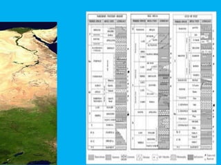
Hydorogeologic units
**Irrigation in the study area depends mainly on
the surface water derived from the Nile River
through main canals and secondary channels
The Nile Delta Quaternary aquifer
The Nile Delta Quaternary aquifer is considered
as a semi-confined aquifer
It covers the whole Nile Delta.
Its thickness varies from 200m in the southern
parts to 1000m in the northern parts
The depth to the groundwater table in this
aquifer ranges between 1–2m in the North, 3–
4m in the Middle and 5m in the South.
the top of the Quaternary aquifer is covered by
a thin clay layer, which leads to the
characterization of this main aquifer as
a semi-confined aquifer.
The thickness of the clay layer varies from
5–20m in the south and the middle part of the
delta, and reaches 50m in the north
Oligocene Aquifer
The Oligocene aquifer consists of sands and
gravels with clay interbeds as well as thin
limestone bands at
the base and thick (30 m) basaltic sheet at top
(Fig. 2). The Oligocene sediments fill the main
channel of Wadi El Natrun with a total
thickness of about 400 m
Moghra (Miocene) Aquifer
The Moghra aquifer is located in the western
Delta with a thickness ranging from 50 to 250
m. It covers about 50,000 km2. The
groundwater flow in the Moghra aquifer is in
general directed westward, towards the
Qattara Depression .
The Moghra aquifer is mainly composed of sand
and sandstone with clay intercalation of
fluviatile and fluviomarine origin.
.
The aquifer thickness varies from few tens of
meters at the eastern side to 150 m in Wadi
El Farigh area and 250 m in Wadi El Natrun
area
It gradually increases in the northwest direction
to attain the maximum thickness
at about 1,000 m in the vicinity of Qattara
Depression and Sidi Barrani.
Wadi El Natrun (Pliocene) Aquifer
Wadi El Natrun aquifer is a local aquifer in the
Pliocene beds that rests on top of Moghra
The groundwater of the Pliocene aquifer varies
from fresh to brackish water.
The Pliocene aquifer is mainly fed by lateral
seepage from the Delta and Moghra aquifers
It also recharges from the south by the Nile
Delta water through Wadi El Farigh
.
The thickness of this aquifer reaches to 140 m
with a saturated thickness of 90 m. The
thickness decreases from east to west and
southwards of Wadi El Natrun.
.
Semi-confined (Quaternar
Unconfined (Quaternary)
Sand dunes
Coastal aquifer
Pliocene aquifer
Oligocene aquifer
Miocene aquifer
Cairo-Alex. Desert Road
Fig. 3: The groundwater
aquifers in the western Nile
Delta (after RIGW, 1991).
The quality of the groundwater in this area may
be strongly affected by the impact of the sea
level rise combined with changes of Nile river
flows, leading to an increase
in the salinity levels of groundwater (Dawoud,
2004). In addition, the current and future
human activities
The Nile Delta Basin experienced a major regression during
theupper Miocene as the rest of the Mediterranean, with
deposition of evaporitic deposits of Rosetta formation and
fluvial to marginal marinefacies deposited in deep incised
valleys as the Abu Madi Formation(Fig.2). During the Lower
Pliocene, the sea level started to raise giving place to a
generalized transgression bringing bathyal facies above
therestricted Messinian units all along the Egyptian
continental shelf. Theoverall sedimentary pattern of the Plio-
Pleistocene succession of the NileDelta is characterized by a
dominant progradation with large scaleclinoforms and an
evident northward migration of the shelf break,nevertheless
some backstepping phases occurred (Abdel Aal
et al
3. General stratigraphy of north Nile Delta basin:
1994).Facies within the Plio-Pleistocene section are deposited
in marginal toopen marine setting, characterized by shelf
sediments progradingnorthward and discharging turbidity
flows along the slope and basin.The Pliocene Kafr El Sheikh
Formation is a thick assemblage of clasticsediments, 98% of
which is shale deposited by the sediment input of the Nile
Delta. Reservoir facies in the Kafr El Sheikh within the
NileDelta consist of channel sands which typically are
relatively massivewith a fining upward trend (Maguire
et al
., 2008).The Plio-Pleistocene sequences were deposited in a
slope to basinfloor setting. Basin-fill models calibrated by
detailed sequence stratigraphicanalysis in the explored part of
the Nile Delta predict a variety of turbidite environments
affected by syn-depositional fault movement and
. The Reservoirs in Nile Delta:
Tectonic activity throughout the Late Mesozoic
and later periodsresulted in a variety of
structural styles, which influenced the patternof
sediment transport into the Mediterranean basins
(El Heiny, 1996).Presently, the Upper Miocene
and the Pliocene sections are thought tocontain
the principal reservoir targets in Mediterranean
Block (AbdelAal
et al
., 2000)
**
-
-
»
USGS)
Well Design
• Purpose of well
• Water Supply
• Contaminant Extraction
• Monitoring
• Injection
• Vadose Zone Monitoring
• Soil Vapor Extraction
• Well diameter
• _Dictated by size of pump
_Affects cost of the well
_Must ensure good
hydraulic efficiency
• Well depth
– Complete to the
– bottom of the aquifer
– More aquifer thickness
– utilized
– _Higher specific capacity
(Q/s, discharge per unit
of drawdown)
.
•**Casing and Borehole Designed from the
Inside-Out:
Purpose of the Well
Pump Size
_Casing & Screen Diameter
_Annulus Tubing String and Material Needs
_Borehole Size
_Surface Casing Size
_Surface Borehole Diameter
**Screen and Filter Pack Designed
from Outside-In
Sieve Analysis
_Filter Pack
_Well Screen
•Screen:
Head loss through perforated well section
_Percentage of open area (minimum 15%)
_Diameter depends on well yield and aquifer
thickness
_Entrance velocities must be limited
Vs = entrance velocity
Q = pumping rate
c = clogging cefficient
Ds = screen diameter
Ls = screen length
P = Percent open area
.

.
.
PRESNTED BY :
1_ Moustafa Mohamed Abd_Elkriem
2_Eslam Hassan Kamel
3_Amed Mahmoud Abd_Elhamied
4_Ahmed El_Sayed Hamza
5_kareem Abo_Elaenyn
2_GEOPHYSICS
TO:PROF: KAMAL GHODIEF

Hydro

  • 1.
    Hydorogeologic units **Irrigation inthe study area depends mainly on the surface water derived from the Nile River through main canals and secondary channels
  • 2.
    The Nile DeltaQuaternary aquifer The Nile Delta Quaternary aquifer is considered as a semi-confined aquifer It covers the whole Nile Delta. Its thickness varies from 200m in the southern parts to 1000m in the northern parts The depth to the groundwater table in this aquifer ranges between 1–2m in the North, 3– 4m in the Middle and 5m in the South.
  • 3.
    the top ofthe Quaternary aquifer is covered by a thin clay layer, which leads to the characterization of this main aquifer as a semi-confined aquifer. The thickness of the clay layer varies from 5–20m in the south and the middle part of the delta, and reaches 50m in the north
  • 4.
    Oligocene Aquifer The Oligoceneaquifer consists of sands and gravels with clay interbeds as well as thin limestone bands at the base and thick (30 m) basaltic sheet at top (Fig. 2). The Oligocene sediments fill the main channel of Wadi El Natrun with a total thickness of about 400 m
  • 5.
    Moghra (Miocene) Aquifer TheMoghra aquifer is located in the western Delta with a thickness ranging from 50 to 250 m. It covers about 50,000 km2. The groundwater flow in the Moghra aquifer is in general directed westward, towards the Qattara Depression . The Moghra aquifer is mainly composed of sand and sandstone with clay intercalation of fluviatile and fluviomarine origin.
  • 6.
    . The aquifer thicknessvaries from few tens of meters at the eastern side to 150 m in Wadi El Farigh area and 250 m in Wadi El Natrun area It gradually increases in the northwest direction to attain the maximum thickness at about 1,000 m in the vicinity of Qattara Depression and Sidi Barrani.
  • 7.
    Wadi El Natrun(Pliocene) Aquifer Wadi El Natrun aquifer is a local aquifer in the Pliocene beds that rests on top of Moghra The groundwater of the Pliocene aquifer varies from fresh to brackish water. The Pliocene aquifer is mainly fed by lateral seepage from the Delta and Moghra aquifers It also recharges from the south by the Nile Delta water through Wadi El Farigh
  • 8.
    . The thickness ofthis aquifer reaches to 140 m with a saturated thickness of 90 m. The thickness decreases from east to west and southwards of Wadi El Natrun.
  • 9.
    . Semi-confined (Quaternar Unconfined (Quaternary) Sanddunes Coastal aquifer Pliocene aquifer Oligocene aquifer Miocene aquifer Cairo-Alex. Desert Road Fig. 3: The groundwater aquifers in the western Nile Delta (after RIGW, 1991).
  • 10.
    The quality ofthe groundwater in this area may be strongly affected by the impact of the sea level rise combined with changes of Nile river flows, leading to an increase in the salinity levels of groundwater (Dawoud, 2004). In addition, the current and future human activities
  • 11.
    The Nile DeltaBasin experienced a major regression during theupper Miocene as the rest of the Mediterranean, with deposition of evaporitic deposits of Rosetta formation and fluvial to marginal marinefacies deposited in deep incised valleys as the Abu Madi Formation(Fig.2). During the Lower Pliocene, the sea level started to raise giving place to a generalized transgression bringing bathyal facies above therestricted Messinian units all along the Egyptian continental shelf. Theoverall sedimentary pattern of the Plio- Pleistocene succession of the NileDelta is characterized by a dominant progradation with large scaleclinoforms and an evident northward migration of the shelf break,nevertheless some backstepping phases occurred (Abdel Aal et al 3. General stratigraphy of north Nile Delta basin:
  • 12.
    1994).Facies within thePlio-Pleistocene section are deposited in marginal toopen marine setting, characterized by shelf sediments progradingnorthward and discharging turbidity flows along the slope and basin.The Pliocene Kafr El Sheikh Formation is a thick assemblage of clasticsediments, 98% of which is shale deposited by the sediment input of the Nile Delta. Reservoir facies in the Kafr El Sheikh within the NileDelta consist of channel sands which typically are relatively massivewith a fining upward trend (Maguire et al ., 2008).The Plio-Pleistocene sequences were deposited in a slope to basinfloor setting. Basin-fill models calibrated by detailed sequence stratigraphicanalysis in the explored part of the Nile Delta predict a variety of turbidite environments affected by syn-depositional fault movement and
  • 13.
    . The Reservoirsin Nile Delta: Tectonic activity throughout the Late Mesozoic and later periodsresulted in a variety of structural styles, which influenced the patternof sediment transport into the Mediterranean basins (El Heiny, 1996).Presently, the Upper Miocene and the Pliocene sections are thought tocontain the principal reservoir targets in Mediterranean Block (AbdelAal et al ., 2000)
  • 14.
  • 17.
  • 19.
    Well Design • Purposeof well • Water Supply • Contaminant Extraction • Monitoring • Injection • Vadose Zone Monitoring • Soil Vapor Extraction
  • 20.
    • Well diameter •_Dictated by size of pump _Affects cost of the well _Must ensure good hydraulic efficiency • Well depth – Complete to the – bottom of the aquifer – More aquifer thickness – utilized – _Higher specific capacity (Q/s, discharge per unit of drawdown)
  • 21.
  • 22.
    •**Casing and BoreholeDesigned from the Inside-Out: Purpose of the Well Pump Size _Casing & Screen Diameter _Annulus Tubing String and Material Needs _Borehole Size _Surface Casing Size _Surface Borehole Diameter **Screen and Filter Pack Designed from Outside-In Sieve Analysis _Filter Pack _Well Screen
  • 23.
    •Screen: Head loss throughperforated well section _Percentage of open area (minimum 15%) _Diameter depends on well yield and aquifer thickness _Entrance velocities must be limited Vs = entrance velocity Q = pumping rate c = clogging cefficient Ds = screen diameter Ls = screen length P = Percent open area
  • 25.
  • 28.
  • 29.
  • 30.
    PRESNTED BY : 1_Moustafa Mohamed Abd_Elkriem 2_Eslam Hassan Kamel 3_Amed Mahmoud Abd_Elhamied 4_Ahmed El_Sayed Hamza 5_kareem Abo_Elaenyn 2_GEOPHYSICS TO:PROF: KAMAL GHODIEF