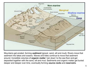
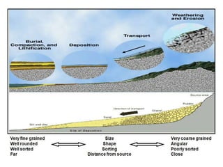
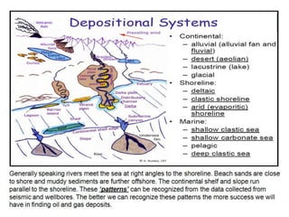
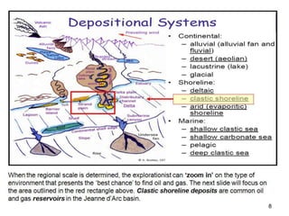
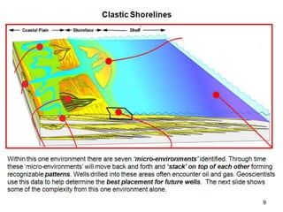
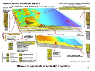
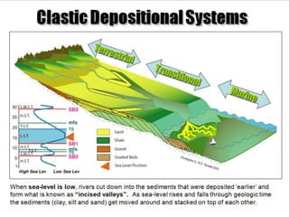
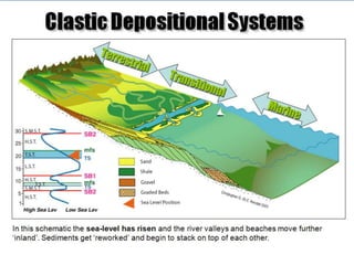
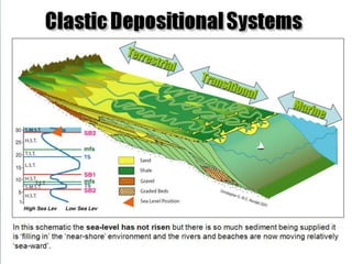
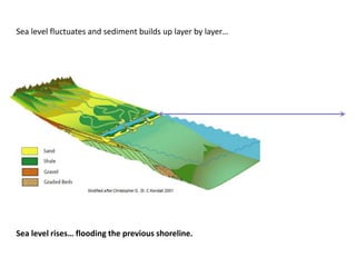
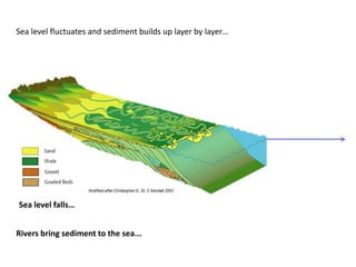
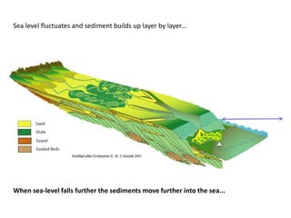
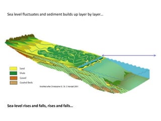
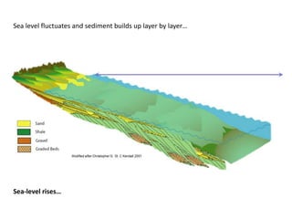
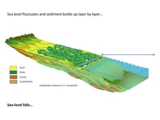
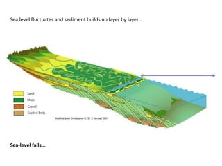
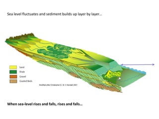
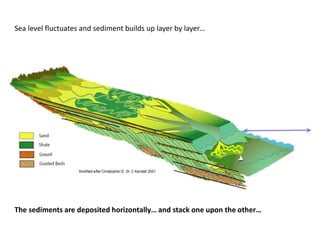
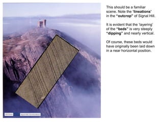
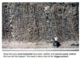
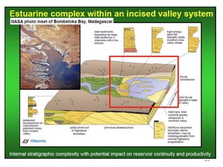
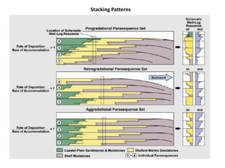
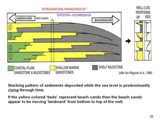
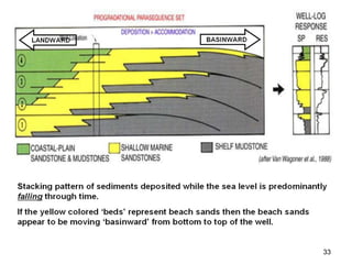
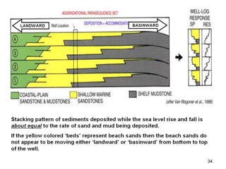
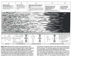
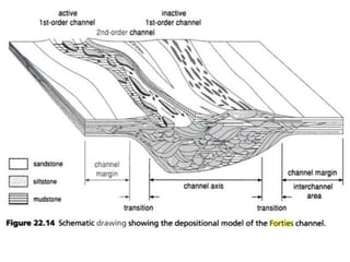
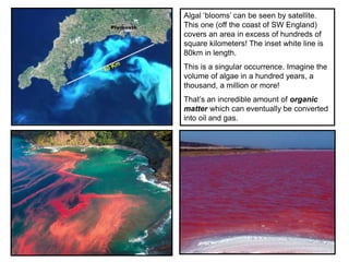
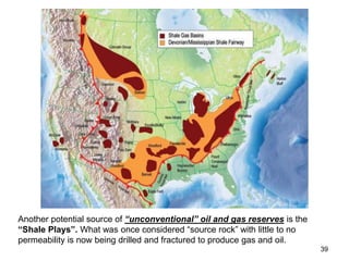
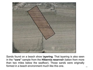
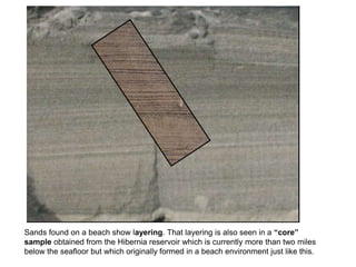
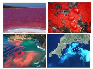
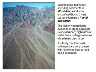
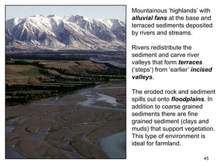
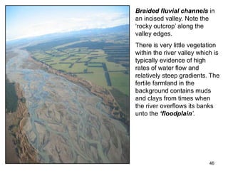
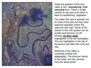
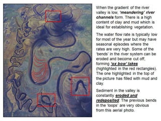
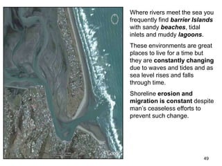
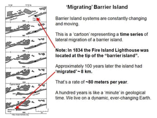
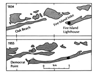
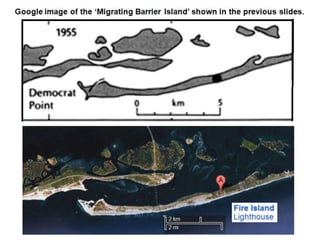
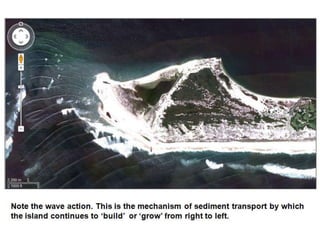
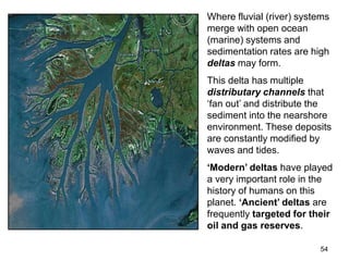
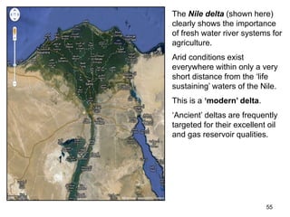
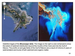
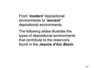
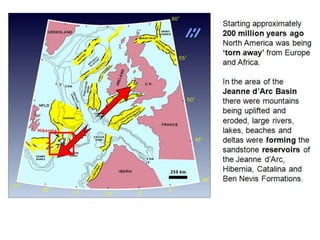
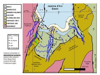
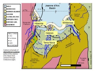
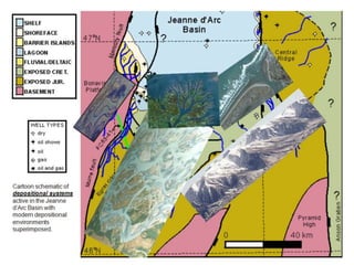
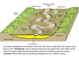
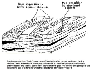
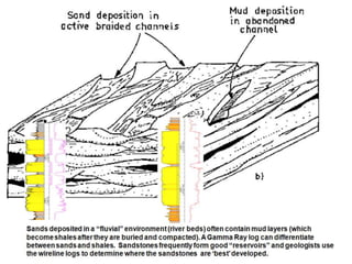
Chapter
Environments…
of Deposition.
07
Chapter
Environments…
of Deposition.
07
A River runs through it….
3
The ‘Oil Patch’ in a Clamshell
Environments of Deposition
Where do the reservoir rocks come from?
4
5
Mountains get eroded, forming sediment (gravel, sand, silt and mud). Rivers move that
sediment into lakes and oceans. Waves and tides continue to move that sediment
around. Incredible volumes of organic matter ‘rain down’ to the sea floor and get
deposited together with the sand, silt and mud. Sediments and organic matter get buried
deeper and deeper over time, eventually forming source rocks and reservoirs.
6
7
8
9
10
Micro-Environments of a Clastic Shoreline
Sea level fluctuates and sediment builds up layer by layer…
Sea level rises… flooding the previous shoreline.
Sea level fluctuates and sediment builds up layer by layer…
Rivers bring sediment to the sea...
Sea level falls…
Sea level fluctuates and sediment builds up layer by layer…
When sea-level falls further the sediments move further into the sea...
Sea level fluctuates and sediment builds up layer by layer…
Sea-level rises and falls, rises and falls…
Sea level fluctuates and sediment builds up layer by layer…
Sea-level rises…
Sea level fluctuates and sediment builds up layer by layer…
Sea-level falls…
Sea level fluctuates and sediment builds up layer by layer…
Sea-level rises…
Sea level fluctuates and sediment builds up layer by layer…
Sea-level falls…
Sea level fluctuates and sediment builds up layer by layer…
When sea-level rises and falls, rises and falls…
Sea level fluctuates and sediment builds up layer by layer…
The sediments are deposited horizontally… and stack one upon the other…
The ‘Stacking Pattern’ and ‘layering’ of sediments
can be seen in the next couple of slides in ‘small’
scale by way of the layers of beach sands and on a
much ‘larger’ scale in whole mountains (especially
evident in places like the Grand Canyon).
Geoscientists must always be aware of the scale of
the data-sets that they are working with.
Sands found on a beach show layering. That layering is also seen in a “core”
sample obtained from the Hibernia reservoir which is currently more than two miles
below the seafloor but which originally formed in a beach environment just like this.
That layering seen in a “core” sample can also be seen on a much larger scale
over vast distances in hills and mountains. Studies of “outcrops” help geologists
determine where to look for oil and gas in the “subsurface”.
This should be a familiar
scene. Note the ‘lineations’
in the “outcrop” of Signal Hill.
It is evident that the ‘layering’
of the “beds” is very steeply
“dipping” and nearly vertical.
Of course, these beds would
have originally been laid down
in a near horizontal position.
This should be a familiar
scene. Note the ‘lineations’
in the “outcrop” of Signal Hill.
It is evident that the ‘layering’
of the “beds” is very steeply
“dipping” and nearly vertical.
Of course, these beds would
have originally been laid down
in a near horizontal position.
30
Stacking Patterns
32
33
34
37
38
Algal ‘blooms’ can be seen by satellite.
This one (off the coast of SW England)
covers an area in excess of hundreds of
square kilometers! The inset white line is
80km in length.
This is a singular occurrence. Imagine the
volume of algae in a hundred years, a
thousand, a million or more!
That’s an incredible amount of organic
matter which can eventually be converted
into oil and gas.
39
Another potential source of “unconventional” oil and gas reserves is the
“Shale Plays”. What was once considered “source rock” with little to no
permeability is now being drilled and fractured to produce gas and oil.
Sands found on a beach show layering. That layering is also seen
in the “core” sample from the Hibernia reservoir (taken from more
than two miles below the seafloor). Those sands were originally
formed in a beach environment much like this one. 40
Sands found on a beach show layering. That layering is also seen in a “core”
sample obtained from the Hibernia reservoir which is currently more than two miles
below the seafloor but which originally formed in a beach environment just like this.
42
43
Oil and Gas reservoirs occur in sediments that
were deposited and buried in ‘ancient’
depositional environments.
The following slides show these environments in
‘modern’ settings.
The current Hibernia, Terra Nova, White Rose
and Hebron Fields that are buried thousands of
meters below the sea-floor were once much like
these environments, at or near sea-level.
44
45
Mountainous ‘highlands’ with
alluvial fans at the base and
terraced sediments deposited
by rivers and streams.
Rivers redistribute the
sediment and carve river
valleys that form terraces
(‘steps’) from ‘earlier’ incised
valleys.
The eroded rock and sediment
spills out onto floodplains. In
addition to coarse grained
sediments there are fine
grained sediment (clays and
muds) that support vegetation.
This type of environment is
ideal for farmland.
46
Braided fluvial channels in
an incised valley. Note the
‘rocky outcrop’ along the
valley edges.
There is very little vegetation
within the river valley which is
typically evidence of high
rates of water flow and
relatively steep gradients. The
fertile farmland in the
background contains muds
and clays from times when
the river overflows its banks
unto the ‘floodplain’.
49
Where rivers meet the sea you
frequently find barrier Islands
with sandy beaches, tidal
inlets and muddy lagoons.
These environments are great
places to live for a time but
they are constantly changing
due to waves and tides and as
sea level rises and falls
through time.
Shoreline erosion and
migration is constant despite
man’s ceaseless efforts to
prevent such change.
54
Where fluvial (river) systems
merge with open ocean
(marine) systems and
sedimentation rates are high
deltas may form.
This delta has multiple
distributary channels that
‘fan out’ and distribute the
sediment into the nearshore
environment. These deposits
are constantly modified by
waves and tides.
‘Modern’ deltas have played
a very important role in the
history of humans on this
planet. ‘Ancient’ deltas are
frequently targeted for their
oil and gas reserves.
55
The Nile delta (shown here)
clearly shows the importance
of fresh water river systems for
agriculture.
Arid conditions exist
everywhere within only a very
short distance from the ‘life
sustaining’ waters of the Nile.
This is a ‘modern’ delta.
‘Ancient’ deltas are frequently
targeted for their excellent oil
and gas reservoir qualities.
56
57
From ‘modern’ depositional
environments to ‘ancient’
depositional environments.
The following slides illustrate the
types of depositional environments
that contribute to the reservoirs
found in the Jeanne d’Arc Basin.
59
The yellow highlighted area indicates ‘sand’ and ‘silt’ (even smaller than the smallest sand
grains). The “meandering” river or stream moves from one side of the ‘river valley’ to the
other. This type of depositional environment produces excellent quality oil and gas
reservoirs when/if they are buried deeply underground over millions of years.
Sandstorms move ‘mountains’ of sediment, sand and silt.

DEPOSITIONAL_ENVIRONMENTS_Lesson_07

  • 1.
  • 2.
  • 3.
    3 The ‘Oil Patch’in a Clamshell Environments of Deposition Where do the reservoir rocks come from?
  • 4.
  • 5.
    5 Mountains get eroded,forming sediment (gravel, sand, silt and mud). Rivers move that sediment into lakes and oceans. Waves and tides continue to move that sediment around. Incredible volumes of organic matter ‘rain down’ to the sea floor and get deposited together with the sand, silt and mud. Sediments and organic matter get buried deeper and deeper over time, eventually forming source rocks and reservoirs.
  • 6.
  • 7.
  • 8.
  • 9.
  • 10.
    10 Micro-Environments of aClastic Shoreline
  • 14.
    Sea level fluctuatesand sediment builds up layer by layer… Sea level rises… flooding the previous shoreline.
  • 15.
    Sea level fluctuatesand sediment builds up layer by layer… Rivers bring sediment to the sea... Sea level falls…
  • 16.
    Sea level fluctuatesand sediment builds up layer by layer… When sea-level falls further the sediments move further into the sea...
  • 17.
    Sea level fluctuatesand sediment builds up layer by layer… Sea-level rises and falls, rises and falls…
  • 18.
    Sea level fluctuatesand sediment builds up layer by layer… Sea-level rises…
  • 19.
    Sea level fluctuatesand sediment builds up layer by layer… Sea-level falls…
  • 20.
    Sea level fluctuatesand sediment builds up layer by layer… Sea-level rises…
  • 21.
    Sea level fluctuatesand sediment builds up layer by layer… Sea-level falls…
  • 22.
    Sea level fluctuatesand sediment builds up layer by layer… When sea-level rises and falls, rises and falls…
  • 23.
    Sea level fluctuatesand sediment builds up layer by layer… The sediments are deposited horizontally… and stack one upon the other…
  • 24.
    The ‘Stacking Pattern’and ‘layering’ of sediments can be seen in the next couple of slides in ‘small’ scale by way of the layers of beach sands and on a much ‘larger’ scale in whole mountains (especially evident in places like the Grand Canyon). Geoscientists must always be aware of the scale of the data-sets that they are working with.
  • 25.
    Sands found ona beach show layering. That layering is also seen in a “core” sample obtained from the Hibernia reservoir which is currently more than two miles below the seafloor but which originally formed in a beach environment just like this.
  • 26.
    That layering seenin a “core” sample can also be seen on a much larger scale over vast distances in hills and mountains. Studies of “outcrops” help geologists determine where to look for oil and gas in the “subsurface”.
  • 27.
    This should bea familiar scene. Note the ‘lineations’ in the “outcrop” of Signal Hill. It is evident that the ‘layering’ of the “beds” is very steeply “dipping” and nearly vertical. Of course, these beds would have originally been laid down in a near horizontal position.
  • 28.
    This should bea familiar scene. Note the ‘lineations’ in the “outcrop” of Signal Hill. It is evident that the ‘layering’ of the “beds” is very steeply “dipping” and nearly vertical. Of course, these beds would have originally been laid down in a near horizontal position.
  • 30.
  • 31.
  • 32.
  • 33.
  • 34.
  • 37.
  • 38.
    38 Algal ‘blooms’ canbe seen by satellite. This one (off the coast of SW England) covers an area in excess of hundreds of square kilometers! The inset white line is 80km in length. This is a singular occurrence. Imagine the volume of algae in a hundred years, a thousand, a million or more! That’s an incredible amount of organic matter which can eventually be converted into oil and gas.
  • 39.
    39 Another potential sourceof “unconventional” oil and gas reserves is the “Shale Plays”. What was once considered “source rock” with little to no permeability is now being drilled and fractured to produce gas and oil.
  • 40.
    Sands found ona beach show layering. That layering is also seen in the “core” sample from the Hibernia reservoir (taken from more than two miles below the seafloor). Those sands were originally formed in a beach environment much like this one. 40
  • 41.
    Sands found ona beach show layering. That layering is also seen in a “core” sample obtained from the Hibernia reservoir which is currently more than two miles below the seafloor but which originally formed in a beach environment just like this.
  • 42.
  • 43.
    43 Oil and Gasreservoirs occur in sediments that were deposited and buried in ‘ancient’ depositional environments. The following slides show these environments in ‘modern’ settings. The current Hibernia, Terra Nova, White Rose and Hebron Fields that are buried thousands of meters below the sea-floor were once much like these environments, at or near sea-level.
  • 44.
  • 45.
    45 Mountainous ‘highlands’ with alluvialfans at the base and terraced sediments deposited by rivers and streams. Rivers redistribute the sediment and carve river valleys that form terraces (‘steps’) from ‘earlier’ incised valleys. The eroded rock and sediment spills out onto floodplains. In addition to coarse grained sediments there are fine grained sediment (clays and muds) that support vegetation. This type of environment is ideal for farmland.
  • 46.
    46 Braided fluvial channelsin an incised valley. Note the ‘rocky outcrop’ along the valley edges. There is very little vegetation within the river valley which is typically evidence of high rates of water flow and relatively steep gradients. The fertile farmland in the background contains muds and clays from times when the river overflows its banks unto the ‘floodplain’.
  • 49.
    49 Where rivers meetthe sea you frequently find barrier Islands with sandy beaches, tidal inlets and muddy lagoons. These environments are great places to live for a time but they are constantly changing due to waves and tides and as sea level rises and falls through time. Shoreline erosion and migration is constant despite man’s ceaseless efforts to prevent such change.
  • 54.
    54 Where fluvial (river)systems merge with open ocean (marine) systems and sedimentation rates are high deltas may form. This delta has multiple distributary channels that ‘fan out’ and distribute the sediment into the nearshore environment. These deposits are constantly modified by waves and tides. ‘Modern’ deltas have played a very important role in the history of humans on this planet. ‘Ancient’ deltas are frequently targeted for their oil and gas reserves.
  • 55.
    55 The Nile delta(shown here) clearly shows the importance of fresh water river systems for agriculture. Arid conditions exist everywhere within only a very short distance from the ‘life sustaining’ waters of the Nile. This is a ‘modern’ delta. ‘Ancient’ deltas are frequently targeted for their excellent oil and gas reservoir qualities.
  • 56.
  • 57.
    57 From ‘modern’ depositional environmentsto ‘ancient’ depositional environments. The following slides illustrate the types of depositional environments that contribute to the reservoirs found in the Jeanne d’Arc Basin.
  • 59.
  • 62.
    The yellow highlightedarea indicates ‘sand’ and ‘silt’ (even smaller than the smallest sand grains). The “meandering” river or stream moves from one side of the ‘river valley’ to the other. This type of depositional environment produces excellent quality oil and gas reservoirs when/if they are buried deeply underground over millions of years.
  • 65.
    Sandstorms move ‘mountains’of sediment, sand and silt.
  • 66.
    Sandstorms move ‘mountains’of sediment, sand and silt.
  • 67.
    Sandstorms move ‘mountains’of sediment, sand and silt.