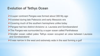
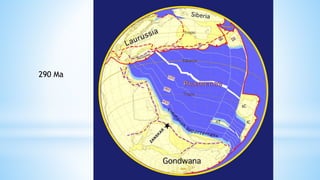
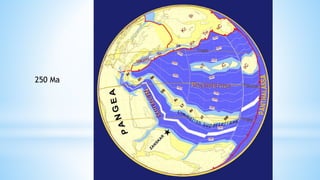
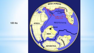
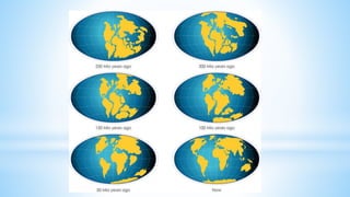
Evolution of Tethys Ocean and
Collision of INDIAN PLATE WITH
EURASIAN PLATE
By Mukhtiar Ghani
mukhtiarghani@upesh.edu.pk
Introduction
 The collision of Indian and Eurasian plates has significantly changed the
surface of the earth
 Producing one of the most spectacular orogenic mountain ranges called the
Himalayas.
 Contains some of the highest mountains on earth.
 Triggering ice ages.
Evolution of Tethys Ocean
A super continent Pangea was formed about 300 My ago
It existed during late Paleozoic and early Mesozoic era
Covering much of the southern hemisphere unlike today
Pangea had two distinct divisions i.e. Laurasia and Gondwanaland
The Pangea was surrounded by a super ocean called Panthalassa
Smaller ocean called paleo Tethys ocean occupied an area between Laurasia
and Gondwanaland
It was narrow in the west and extremely wide in the east forming a gulf
290 Ma
The India-Asia collision is a part of a long accretion history of small
sized microcontinents
Originated from the break-up of Gondwanaland in the Paleozoic
(Bond et al., 1984).
progressively accreted from then on
contributed to the growth of the Asian margin southwards (Matte et
al., 1996).
These were accreted in three episodes:
(1) Variscan
(2) Cimmerian
(3) Alpine
The Cimmerian episode corresponds to the break-up of the
Cimmerian continent from the Gondwana margin.
Began in the Late Permian and was complete during the Triassic
(Sengör et al., 1988).
The closure of the Paleo-Tethys Ocean, and saturation of the
Cimmerian Continents occurred between Middle Triassic (Zanchi et
al., 2000).
Panjal trap volcanism and Peshawar plain alkaline igneous complex
are associated with opening of the Neo-Tethys Ocean (Honnegger et
al., 1982).
250 Ma
The Kohistan Ladakh terrain is characterized by intra oceanic arc
magmatic rocks,
Formed during Middle Cretaceous times (110 to 90 Ma)(Honegger
et al.)
These oceanic terrains are mainly remnants of arc-series reflecting
intra-oceanic subduction of the Neo-Tethys in the north.
The central part of the Karakoram terrain is comprised of the NW-
SE striking composite calc-alkaline Karakoram Batholith
Emplaced between 120 and 88 Ma in response to northwards
subduction of Tethyan oceanic crust (Debon et al., 1987)
These terrains were subsequently accreted to the Asian margin
during the Late Cretaceous (80 to 88 Ma)(Weinberg et al., 2000),
along the Shyok suture zone.
Gondwanaland split into two parts at about 210 Ma i.e. East
Gondwana and West Gondwana.
The Indian plate became a part of East Gondwana together with
Australia and Antarctica
In early cretaceous at about 130 million years ago India separated
from the other continents
Started rapid movement towards north covering a distance of 6000
km.
This happened because of formation of Indian ocean in the south
due to rifting
Ocean-ocean subduction in the northern margin of Tethys.
Finally the Tethys Ocean closed and India collided with Eurasia.
100 Ma
Collisional Events
The exact time of collision of India with Eurasia is always debated
Estimated to have happened in range of 70 to 25 Ma.
Since 55 million years ago, India has steadily rotated counterclockwise
Coupled with Arabia's separation from Africa about 20 million years ago.
This rotation caused convergence in Baluchistan, closure of some of the
smaller basins (Seistan, Katawaz), collision of various crustal blocks in
Iran-Afghanistan region and formation of the Baluchistan fold-and-thrust
belt.
The India-Eurasia collision produced the spectacular Himalayas along
uplifted and deformed 2,500 km long Indo-Pakistan plate margin.
*Between 65 and 55 Ma, the Kohistan Ladakh Arcs were obducted
onto the Indian margin along the Main Mantle Thrust (MMT,
Tahirkheli et al., 1979).
*Magnetic studies have evidenced an abrupt decrease in
convergence rate, from 18-19.5 cm.y-1 to 4.5 cm.y-1, at ~ 50 Ma for
Patriat & Achache (1984)
*This drop in convergence rate coincides with a reduction in the
spreading rate of SW and central Mid-Indian Ocean ridge at 56 – 50
Ma (Molnar & Tapponnier, 1975)
The timing of the collision is constrained by extensive emplacement of
ophiolites along the Indus- Tsango Suture Zone, in Waziristan, Zhob
Valley and Lasbela area.
Along suture zones the youngest marine sediments are lower Eocene.
At places Indus molasse overlies Early Eocene limestone and contains
debris both of Eurasian and Indian terrains.
Compressional tectonic began after deposition of Early Eocene
Nummulitic limestone.
Thanks

Evolution of tethys

  • 1.
    Evolution of TethysOcean and Collision of INDIAN PLATE WITH EURASIAN PLATE By Mukhtiar Ghani mukhtiarghani@upesh.edu.pk
  • 2.
    Introduction  The collisionof Indian and Eurasian plates has significantly changed the surface of the earth  Producing one of the most spectacular orogenic mountain ranges called the Himalayas.  Contains some of the highest mountains on earth.  Triggering ice ages.
  • 3.
    Evolution of TethysOcean A super continent Pangea was formed about 300 My ago It existed during late Paleozoic and early Mesozoic era Covering much of the southern hemisphere unlike today Pangea had two distinct divisions i.e. Laurasia and Gondwanaland The Pangea was surrounded by a super ocean called Panthalassa Smaller ocean called paleo Tethys ocean occupied an area between Laurasia and Gondwanaland It was narrow in the west and extremely wide in the east forming a gulf
  • 4.
  • 5.
    The India-Asia collisionis a part of a long accretion history of small sized microcontinents Originated from the break-up of Gondwanaland in the Paleozoic (Bond et al., 1984). progressively accreted from then on contributed to the growth of the Asian margin southwards (Matte et al., 1996). These were accreted in three episodes: (1) Variscan (2) Cimmerian (3) Alpine
  • 6.
    The Cimmerian episodecorresponds to the break-up of the Cimmerian continent from the Gondwana margin. Began in the Late Permian and was complete during the Triassic (Sengör et al., 1988). The closure of the Paleo-Tethys Ocean, and saturation of the Cimmerian Continents occurred between Middle Triassic (Zanchi et al., 2000). Panjal trap volcanism and Peshawar plain alkaline igneous complex are associated with opening of the Neo-Tethys Ocean (Honnegger et al., 1982).
  • 7.
  • 8.
    The Kohistan Ladakhterrain is characterized by intra oceanic arc magmatic rocks, Formed during Middle Cretaceous times (110 to 90 Ma)(Honegger et al.) These oceanic terrains are mainly remnants of arc-series reflecting intra-oceanic subduction of the Neo-Tethys in the north. The central part of the Karakoram terrain is comprised of the NW- SE striking composite calc-alkaline Karakoram Batholith Emplaced between 120 and 88 Ma in response to northwards subduction of Tethyan oceanic crust (Debon et al., 1987) These terrains were subsequently accreted to the Asian margin during the Late Cretaceous (80 to 88 Ma)(Weinberg et al., 2000), along the Shyok suture zone.
  • 9.
    Gondwanaland split intotwo parts at about 210 Ma i.e. East Gondwana and West Gondwana. The Indian plate became a part of East Gondwana together with Australia and Antarctica In early cretaceous at about 130 million years ago India separated from the other continents Started rapid movement towards north covering a distance of 6000 km. This happened because of formation of Indian ocean in the south due to rifting Ocean-ocean subduction in the northern margin of Tethys. Finally the Tethys Ocean closed and India collided with Eurasia.
  • 10.
  • 12.
    Collisional Events The exacttime of collision of India with Eurasia is always debated Estimated to have happened in range of 70 to 25 Ma. Since 55 million years ago, India has steadily rotated counterclockwise Coupled with Arabia's separation from Africa about 20 million years ago. This rotation caused convergence in Baluchistan, closure of some of the smaller basins (Seistan, Katawaz), collision of various crustal blocks in Iran-Afghanistan region and formation of the Baluchistan fold-and-thrust belt. The India-Eurasia collision produced the spectacular Himalayas along uplifted and deformed 2,500 km long Indo-Pakistan plate margin.
  • 13.
    *Between 65 and55 Ma, the Kohistan Ladakh Arcs were obducted onto the Indian margin along the Main Mantle Thrust (MMT, Tahirkheli et al., 1979). *Magnetic studies have evidenced an abrupt decrease in convergence rate, from 18-19.5 cm.y-1 to 4.5 cm.y-1, at ~ 50 Ma for Patriat & Achache (1984) *This drop in convergence rate coincides with a reduction in the spreading rate of SW and central Mid-Indian Ocean ridge at 56 – 50 Ma (Molnar & Tapponnier, 1975)
  • 14.
    The timing ofthe collision is constrained by extensive emplacement of ophiolites along the Indus- Tsango Suture Zone, in Waziristan, Zhob Valley and Lasbela area. Along suture zones the youngest marine sediments are lower Eocene. At places Indus molasse overlies Early Eocene limestone and contains debris both of Eurasian and Indian terrains. Compressional tectonic began after deposition of Early Eocene Nummulitic limestone.
  • 15.