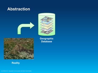
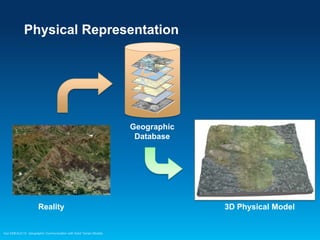
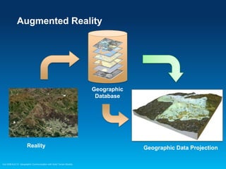
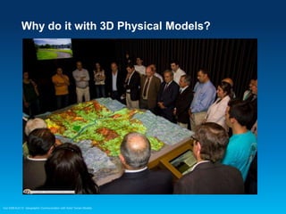
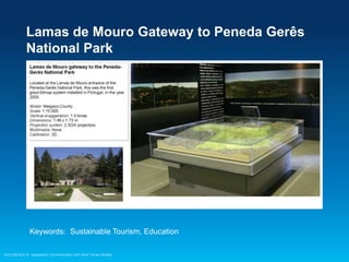
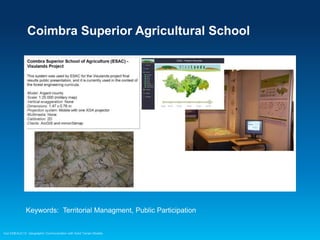
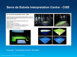
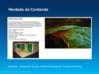
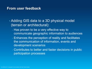
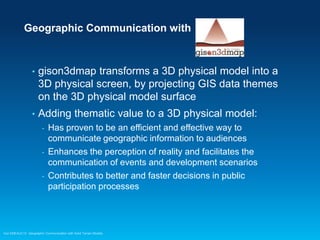
2013 Esri Europe, Middle East and Africa
User Conference
October 23-25, 2013 | Munich, Germany

Geographic Communication
with Solid Terrain Models
Carlos Coucelo, Pedro Duarte, Rita Crespo
CCCGeomática, Portugal

Esri EMEAUC13
The Idea is simple
•

To tell stories about a given territory, synchronized
with the video projection of geographic information
on top of a physical model of that same territory

Esri EMEAUC13 Geographic Communication with Solid Terrain Models
A glance with a video sample
Castro Marim Territory Interpretation Centre

Check for this video on You Tube
Esri EMEAUC13 Geographic Communication with Solid Terrain Models
The Concept
•

From reality to a GIS database and back

Esri EMEAUC13 Geographic Communication with Solid Terrain Models
Abstraction

Geographic
Database

Reality

Esri EMEAUC13 Geographic Communication with Solid Terrain Models
Physical Representation

Geographic
Database

Reality

Esri EMEAUC13 Geographic Communication with Solid Terrain Models

3D Physical Model
Augmented Reality

Geographic
Database

Reality

Esri EMEAUC13 Geographic Communication with Solid Terrain Models

Geographic Data Projection
Why do it with 3D Physical Models?

Esri EMEAUC13 Geographic Communication with Solid Terrain Models
Because...
•

3D physical models are tangible products

•

Scale, distance, slope, orientation, sight line, etc.,
are immediately perceived by everyone in an
audience in a clear and consensual way

•

Physical models are democratic tools: people will
find it easy to understand others and make
themselves understood

Esri EMEAUC13 Geographic Communication with Solid Terrain Models
The result is
•

Beautiful communication

•

Information easier to understand

•

Improved communication with audiences

•

Better public participation

Esri EMEAUC13 Geographic Communication with Solid Terrain Models
How do we do it?
Geographic Data
Projection

Geographic
Database

Esri EMEAUC13 Geographic Communication with Solid Terrain Models
gison3dmap installations in Portugal
1.

Lamas de Mouro Gateway to Peneda GerĂŞs
National Park – Thematic Workshop

2.

Serra da Estrela Interpretation Centre

3.

Coimbra Superior Agricultural School

4.

Herdade da Contenda Interpretation Centre

5.

RAVE – High Speed Train Network

6.

Companhia das LezĂ­rias Visitors Centre

7.

Castro Marim County Interpretation Centre

8.

Batalha County Community Museum

9.

Sintra 3D – Sintra World Heritage Landscape

10.

GuimarĂŁes County Information Centre

11.

River Lima Information Centre

12.

Cascais County Urban Information Centre

13.

Costa Lopes Arquitects

14.

House of Rock Delivering Stones – Arouca Geopark

Esri EMEAUC13 Geographic Communication with Solid Terrain Models
Lamas de Mouro Gateway to Peneda GerĂŞs
National Park

Keywords: Sustainable Tourism, Education
Esri EMEAUC13 Geographic Communication with Solid Terrain Models
Coimbra Superior Agricultural School

Keywords: Territorial Managment, Public Participation

Esri EMEAUC13 Geographic Communication with Solid Terrain Models
Serra da Estrela Interpretation Centre - CISE

Keywords: Sustainable Tourism, Education
Esri EMEAUC13 Geographic Communication with Solid Terrain Models
Herdade da Contenda

Keywords: Sustainable Tourism, Territorial Managment, Touristic Promotion
Esri EMEAUC13 Geographic Communication with Solid Terrain Models
Companhia das LezĂ­rias Visitors Centre

Keywords: Education, Sustainable Tourism, Territorial Managment
Esri EMEAUC13 Geographic Communication with Solid Terrain Models
RAVE – TTT – Third Tejo River Crossing
Exhibition

Keywords: Project Development, Public Participation
Esri EMEAUC13 Geographic Communication with Solid Terrain Models
Castro Marim Territory Interpretation Centre

Keywords: Education, Territorial Managment, Tourism
Esri EMEAUC13 Geographic Communication with Solid Terrain Models
Batalha County Community Museum

Keywords: Education, Tourism
Esri EMEAUC13 Geographic Communication with Solid Terrain Models
Sintra World Heritage Landscape

Keywords: Education, Sustainable Tourism, Territorial Managment
Esri EMEAUC13 Geographic Communication with Solid Terrain Models
GuimarĂŁes County Master Plan Revision
Public Participation

Keywords: Territorial Managment, Public Participation
Esri EMEAUC13 Geographic Communication with Solid Terrain Models
Cascais County Urban Information System

Keywords: Education, Territorial Managment, Tourism
Esri EMEAUC13 Geographic Communication with Solid Terrain Models
River Lima Information Centre

Keywords: Education, Sustainable Tourism, Territorial Managment
Esri EMEAUC13 Geographic Communication with Solid Terrain Models
Costa Lopes Arquitects – Luanda Marina
Development Plan

Keywords: Project presentation, Real Estate Promotion
Esri EMEAUC13 Geographic Communication with Solid Terrain Models
House of Rock Delivering Stones – Arouca
Geopark (UNESCO Geoparks Network)

Keywords: Education, Sustainable Tourism
Esri EMEAUC13 Geographic Communication with Solid Terrain Models
From user feedback

• Adding

GIS data to a 3D physical model
(terrain or architectural):
-

-

Has proven to be a very effective way to
communicate geographic information to audiences
Enhances the perception of reality and facilitates
the communication of information, events and
development scenarios
Contributes to better and faster decisions in public
participation processes

Esri EMEAUC13 Geographic Communication with Solid Terrain Models
How was this system architectured?
•

GIS Database

•

Client server application: gison3dmap

•

Clients:
GIS
- Multimedia
- Presentation (Powerpoint and Android)
- Custom develloped
-

Esri EMEAUC13 Geographic Communication with Solid Terrain Models
System Architecture

Esri EMEAUC13 Geographic Communication with Solid Terrain Models
gison3dmap is a GIS
•

The gison3dmap core is a GIS engine

•

The GIS Database is central to the system – All
projections are database driven and are
consequently dynamic

•

Controler manages projection requests

•

Map displays are associated with video projectors

•

Multimedia displays are used to show images and
videos synchronized with GIS data projections on
the 3D map

Esri EMEAUC13 Geographic Communication with Solid Terrain Models
Clients
- Each

type of user interaction requires a
specific user interface:
-

GIS – for GIS users
Multimedia – for visitors
Presentation – for technicians
-

-

Powerpoint: to geographically illustrate a presentation
Android: to control the system (maps, videos, animations, free
hand drawing, ...)

Custom develloped:
-

Geographic games, multiple users interaction with tablets and
smartphones, natural interfaces, ...

Esri EMEAUC13 Geographic Communication with Solid Terrain Models
GIS clients

Esri EMEAUC13 Geographic Communication with Solid Terrain Models
GIS Clients
•

•
•
•

GIS Clients (ArcGIS and VisualSIG) are central to the
gison3dmap system
All projection requests access GIS data dynamically
GIS clients are used to define what to project and how
gison3dmap
projection requests
can be capured using
the GIS clients to use
within non GIS
clients, such as
Powerpoint

ArcGIS 10 client
Esri EMEAUC13 Geographic Communication with Solid Terrain Models
ArcGIS Online

Esri EMEAUC13 Geographic Communication with Solid Terrain Models
ArcGIS Online

Esri EMEAUC13 Geographic Communication with Solid Terrain Models
Multimedia Clients

Esri EMEAUC13 Geographic Communication with Solid Terrain Models
Multimedia Clients
•

Simple interfaces (menu driven or more flashy)
oriented to the general public

•

Automatic and user controled map projections
synchronized with images and videos

Esri EMEAUC13 Geographic Communication with Solid Terrain Models
Presentation Clients

Esri EMEAUC13 Geographic Communication with Solid Terrain Models
Powerpoint Client
•

Used to geographically illustrate a Powerpoint
presentation

•

Slides are shown on multimedia displays

•

Map projections are trigered by slide transitions

Powerpoint client schema
Esri EMEAUC13 Geographic Communication with Solid Terrain Models
Andoid Client
•

Used to control map projections and videos, execute
command sequences (sun-rise to sun-set shadows,
flood simulations, etc.) and draw graphics

•

Maps available on the client interface are defined
using a GIS project

Esri EMEAUC13 Geographic Communication with Solid Terrain Models
Android Client – Freehand drawing

Check for this video on You Tube
Esri EMEAUC13 Geographic Communication with Solid Terrain Models
Other Clients – gison3dmapQuiz
•

Clients can be developed using the gison3dmap
API or sending commands via a TCP/IP socket

•

gison3dmapQuiz is an example of an application
develloped to implement geographic games

Esri EMEAUC13 Geographic Communication with Solid Terrain Models
Other Clients – gison3dmap Overview
•

Navigate on Web map application while using for
each user the 3D map as a overview map, and to
show locations, lines of sight, etc.

•

This is the way to
go to integrate 3D
virtual scenes, 3D
animations anf fly
throughs with a
solid terrain model

Esri EMEAUC13 Geographic Communication with Solid Terrain Models
Special interfaces
•

Natural (gestures)

•

Laser pointer

Esri EMEAUC13 Geographic Communication with Solid Terrain Models
Calibration

Esri EMEAUC13 Geographic Communication with Solid Terrain Models
Projection calibration
•

Match calibration targets projected on the 3D map
surface with previously defined calibration points

Esri EMEAUC13 Geographic Communication with Solid Terrain Models
Automatic Calibration
•

Calibration can be partially automated, using fiber
optics installed at the calibration points locations,
and a PCB with light sensors and a Arduino board

Esri EMEAUC13 Geographic Communication with Solid Terrain Models
Automatic Calibration

Esri EMEAUC13 Geographic Communication with Solid Terrain Models
Geographic Communication with

•

gison3dmap transforms a 3D physical model into a
3D physical screen, by projecting GIS data themes
on the 3D physical model surface

•

Adding thematic value to a 3D physical model:
-

Has proven to be an efficient and effective way to
communicate geographic information to audiences
Enhances the perception of reality and facilitates the
communication of events and development scenarios
Contributes to better and faster decisions in public
participation processes

Esri EMEAUC13 Geographic Communication with Solid Terrain Models
How to get more info
www.gison3dmap.com

Esri EMEAUC13 Geographic Communication with Solid Terrain Models
Visit us at Orbits Engineering booth on the
GIS Solutions Expo

Esri EMEAUC13 Geographic Communication with Solid Terrain Models
Thanks for listenning
Carlos Coucelo
CCCGeomática, Portugal
carlos@cccgeo.com
www.gison3dmap.com

Esri EMEAUC13 Geographic Communication with Solid Terrain Models

ESRI EMEA Users Conference 2013 - Geographic Communication with Solid Terrain Models

  • 1.
    2013 Esri Europe,Middle East and Africa User Conference October 23-25, 2013 | Munich, Germany Geographic Communication with Solid Terrain Models Carlos Coucelo, Pedro Duarte, Rita Crespo CCCGeomática, Portugal Esri EMEAUC13
  • 2.
    The Idea issimple • To tell stories about a given territory, synchronized with the video projection of geographic information on top of a physical model of that same territory Esri EMEAUC13 Geographic Communication with Solid Terrain Models
  • 3.
    A glance witha video sample Castro Marim Territory Interpretation Centre Check for this video on You Tube Esri EMEAUC13 Geographic Communication with Solid Terrain Models
  • 4.
    The Concept • From realityto a GIS database and back Esri EMEAUC13 Geographic Communication with Solid Terrain Models
  • 5.
  • 6.
    Physical Representation Geographic Database Reality Esri EMEAUC13Geographic Communication with Solid Terrain Models 3D Physical Model
  • 7.
    Augmented Reality Geographic Database Reality Esri EMEAUC13Geographic Communication with Solid Terrain Models Geographic Data Projection
  • 8.
    Why do itwith 3D Physical Models? Esri EMEAUC13 Geographic Communication with Solid Terrain Models
  • 9.
    Because... • 3D physical modelsare tangible products • Scale, distance, slope, orientation, sight line, etc., are immediately perceived by everyone in an audience in a clear and consensual way • Physical models are democratic tools: people will find it easy to understand others and make themselves understood Esri EMEAUC13 Geographic Communication with Solid Terrain Models
  • 10.
    The result is • Beautifulcommunication • Information easier to understand • Improved communication with audiences • Better public participation Esri EMEAUC13 Geographic Communication with Solid Terrain Models
  • 11.
    How do wedo it? Geographic Data Projection Geographic Database Esri EMEAUC13 Geographic Communication with Solid Terrain Models
  • 12.
    gison3dmap installations inPortugal 1. Lamas de Mouro Gateway to Peneda Gerês National Park – Thematic Workshop 2. Serra da Estrela Interpretation Centre 3. Coimbra Superior Agricultural School 4. Herdade da Contenda Interpretation Centre 5. RAVE – High Speed Train Network 6. Companhia das Lezírias Visitors Centre 7. Castro Marim County Interpretation Centre 8. Batalha County Community Museum 9. Sintra 3D – Sintra World Heritage Landscape 10. Guimarães County Information Centre 11. River Lima Information Centre 12. Cascais County Urban Information Centre 13. Costa Lopes Arquitects 14. House of Rock Delivering Stones – Arouca Geopark Esri EMEAUC13 Geographic Communication with Solid Terrain Models
  • 13.
    Lamas de MouroGateway to Peneda GerĂŞs National Park Keywords: Sustainable Tourism, Education Esri EMEAUC13 Geographic Communication with Solid Terrain Models
  • 14.
    Coimbra Superior AgriculturalSchool Keywords: Territorial Managment, Public Participation Esri EMEAUC13 Geographic Communication with Solid Terrain Models
  • 15.
    Serra da EstrelaInterpretation Centre - CISE Keywords: Sustainable Tourism, Education Esri EMEAUC13 Geographic Communication with Solid Terrain Models
  • 16.
    Herdade da Contenda Keywords:Sustainable Tourism, Territorial Managment, Touristic Promotion Esri EMEAUC13 Geographic Communication with Solid Terrain Models
  • 17.
    Companhia das LezĂ­riasVisitors Centre Keywords: Education, Sustainable Tourism, Territorial Managment Esri EMEAUC13 Geographic Communication with Solid Terrain Models
  • 18.
    RAVE – TTT– Third Tejo River Crossing Exhibition Keywords: Project Development, Public Participation Esri EMEAUC13 Geographic Communication with Solid Terrain Models
  • 19.
    Castro Marim TerritoryInterpretation Centre Keywords: Education, Territorial Managment, Tourism Esri EMEAUC13 Geographic Communication with Solid Terrain Models
  • 20.
    Batalha County CommunityMuseum Keywords: Education, Tourism Esri EMEAUC13 Geographic Communication with Solid Terrain Models
  • 21.
    Sintra World HeritageLandscape Keywords: Education, Sustainable Tourism, Territorial Managment Esri EMEAUC13 Geographic Communication with Solid Terrain Models
  • 22.
    GuimarĂŁes County MasterPlan Revision Public Participation Keywords: Territorial Managment, Public Participation Esri EMEAUC13 Geographic Communication with Solid Terrain Models
  • 23.
    Cascais County UrbanInformation System Keywords: Education, Territorial Managment, Tourism Esri EMEAUC13 Geographic Communication with Solid Terrain Models
  • 24.
    River Lima InformationCentre Keywords: Education, Sustainable Tourism, Territorial Managment Esri EMEAUC13 Geographic Communication with Solid Terrain Models
  • 25.
    Costa Lopes Arquitects– Luanda Marina Development Plan Keywords: Project presentation, Real Estate Promotion Esri EMEAUC13 Geographic Communication with Solid Terrain Models
  • 26.
    House of RockDelivering Stones – Arouca Geopark (UNESCO Geoparks Network) Keywords: Education, Sustainable Tourism Esri EMEAUC13 Geographic Communication with Solid Terrain Models
  • 27.
    From user feedback •Adding GIS data to a 3D physical model (terrain or architectural): - - Has proven to be a very effective way to communicate geographic information to audiences Enhances the perception of reality and facilitates the communication of information, events and development scenarios Contributes to better and faster decisions in public participation processes Esri EMEAUC13 Geographic Communication with Solid Terrain Models
  • 28.
    How was thissystem architectured? • GIS Database • Client server application: gison3dmap • Clients: GIS - Multimedia - Presentation (Powerpoint and Android) - Custom develloped - Esri EMEAUC13 Geographic Communication with Solid Terrain Models
  • 29.
    System Architecture Esri EMEAUC13Geographic Communication with Solid Terrain Models
  • 30.
    gison3dmap is aGIS • The gison3dmap core is a GIS engine • The GIS Database is central to the system – All projections are database driven and are consequently dynamic • Controler manages projection requests • Map displays are associated with video projectors • Multimedia displays are used to show images and videos synchronized with GIS data projections on the 3D map Esri EMEAUC13 Geographic Communication with Solid Terrain Models
  • 31.
    Clients - Each type ofuser interaction requires a specific user interface: - GIS – for GIS users Multimedia – for visitors Presentation – for technicians - - Powerpoint: to geographically illustrate a presentation Android: to control the system (maps, videos, animations, free hand drawing, ...) Custom develloped: - Geographic games, multiple users interaction with tablets and smartphones, natural interfaces, ... Esri EMEAUC13 Geographic Communication with Solid Terrain Models
  • 32.
    GIS clients Esri EMEAUC13Geographic Communication with Solid Terrain Models
  • 33.
    GIS Clients • • • • GIS Clients(ArcGIS and VisualSIG) are central to the gison3dmap system All projection requests access GIS data dynamically GIS clients are used to define what to project and how gison3dmap projection requests can be capured using the GIS clients to use within non GIS clients, such as Powerpoint ArcGIS 10 client Esri EMEAUC13 Geographic Communication with Solid Terrain Models
  • 34.
    ArcGIS Online Esri EMEAUC13Geographic Communication with Solid Terrain Models
  • 35.
    ArcGIS Online Esri EMEAUC13Geographic Communication with Solid Terrain Models
  • 36.
    Multimedia Clients Esri EMEAUC13Geographic Communication with Solid Terrain Models
  • 37.
    Multimedia Clients • Simple interfaces(menu driven or more flashy) oriented to the general public • Automatic and user controled map projections synchronized with images and videos Esri EMEAUC13 Geographic Communication with Solid Terrain Models
  • 38.
    Presentation Clients Esri EMEAUC13Geographic Communication with Solid Terrain Models
  • 39.
    Powerpoint Client • Used togeographically illustrate a Powerpoint presentation • Slides are shown on multimedia displays • Map projections are trigered by slide transitions Powerpoint client schema Esri EMEAUC13 Geographic Communication with Solid Terrain Models
  • 40.
    Andoid Client • Used tocontrol map projections and videos, execute command sequences (sun-rise to sun-set shadows, flood simulations, etc.) and draw graphics • Maps available on the client interface are defined using a GIS project Esri EMEAUC13 Geographic Communication with Solid Terrain Models
  • 41.
    Android Client –Freehand drawing Check for this video on You Tube Esri EMEAUC13 Geographic Communication with Solid Terrain Models
  • 42.
    Other Clients –gison3dmapQuiz • Clients can be developed using the gison3dmap API or sending commands via a TCP/IP socket • gison3dmapQuiz is an example of an application develloped to implement geographic games Esri EMEAUC13 Geographic Communication with Solid Terrain Models
  • 43.
    Other Clients –gison3dmap Overview • Navigate on Web map application while using for each user the 3D map as a overview map, and to show locations, lines of sight, etc. • This is the way to go to integrate 3D virtual scenes, 3D animations anf fly throughs with a solid terrain model Esri EMEAUC13 Geographic Communication with Solid Terrain Models
  • 44.
    Special interfaces • Natural (gestures) • Laserpointer Esri EMEAUC13 Geographic Communication with Solid Terrain Models
  • 45.
    Calibration Esri EMEAUC13 GeographicCommunication with Solid Terrain Models
  • 46.
    Projection calibration • Match calibrationtargets projected on the 3D map surface with previously defined calibration points Esri EMEAUC13 Geographic Communication with Solid Terrain Models
  • 47.
    Automatic Calibration • Calibration canbe partially automated, using fiber optics installed at the calibration points locations, and a PCB with light sensors and a Arduino board Esri EMEAUC13 Geographic Communication with Solid Terrain Models
  • 48.
    Automatic Calibration Esri EMEAUC13Geographic Communication with Solid Terrain Models
  • 49.
    Geographic Communication with • gison3dmaptransforms a 3D physical model into a 3D physical screen, by projecting GIS data themes on the 3D physical model surface • Adding thematic value to a 3D physical model: - Has proven to be an efficient and effective way to communicate geographic information to audiences Enhances the perception of reality and facilitates the communication of events and development scenarios Contributes to better and faster decisions in public participation processes Esri EMEAUC13 Geographic Communication with Solid Terrain Models
  • 50.
    How to getmore info www.gison3dmap.com Esri EMEAUC13 Geographic Communication with Solid Terrain Models
  • 51.
    Visit us atOrbits Engineering booth on the GIS Solutions Expo Esri EMEAUC13 Geographic Communication with Solid Terrain Models
  • 52.
    Thanks for listenning CarlosCoucelo CCCGeomática, Portugal carlos@cccgeo.com www.gison3dmap.com Esri EMEAUC13 Geographic Communication with Solid Terrain Models