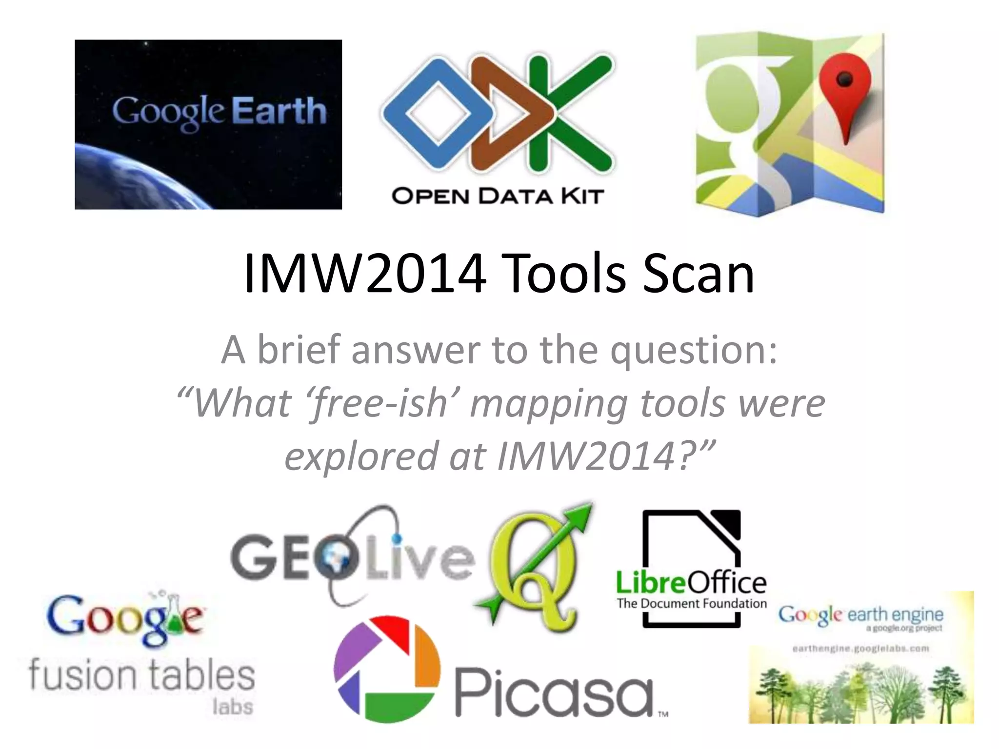
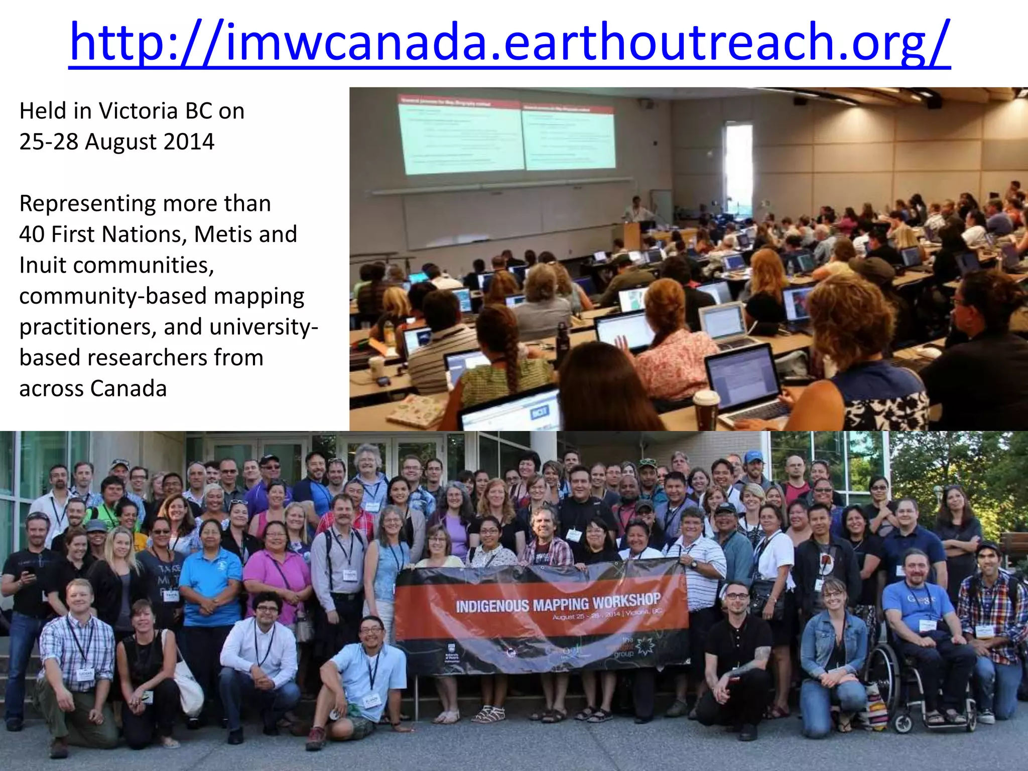
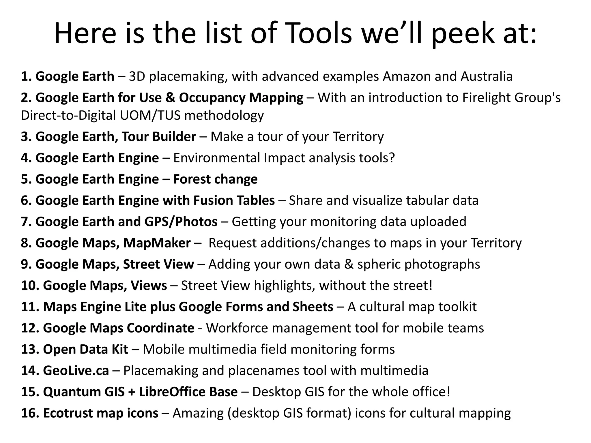
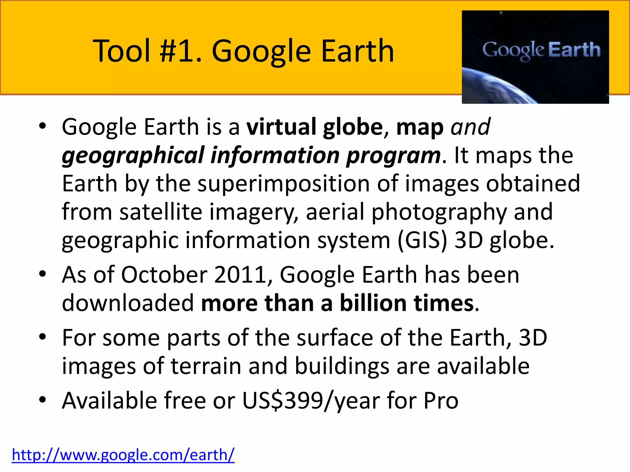
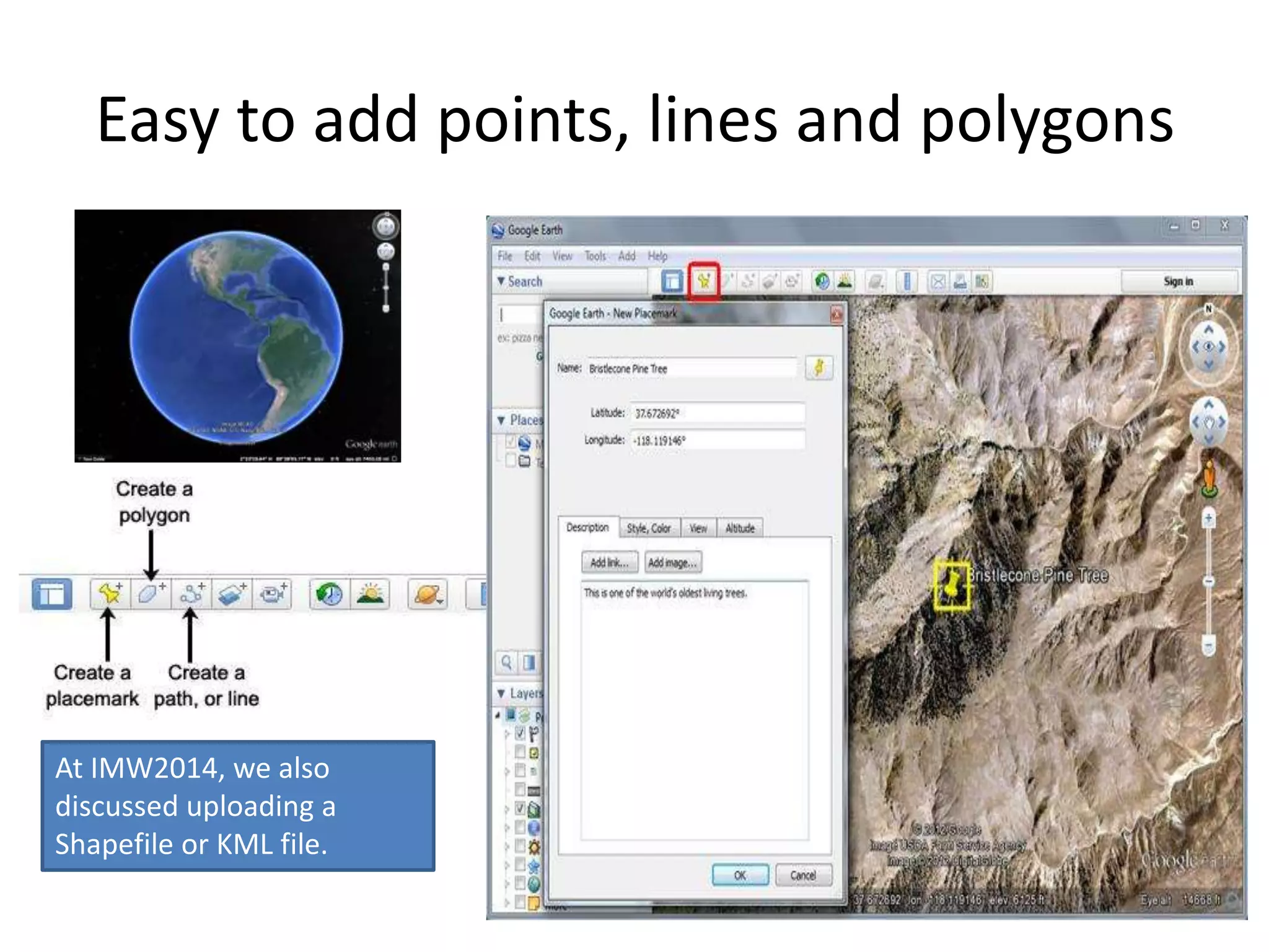
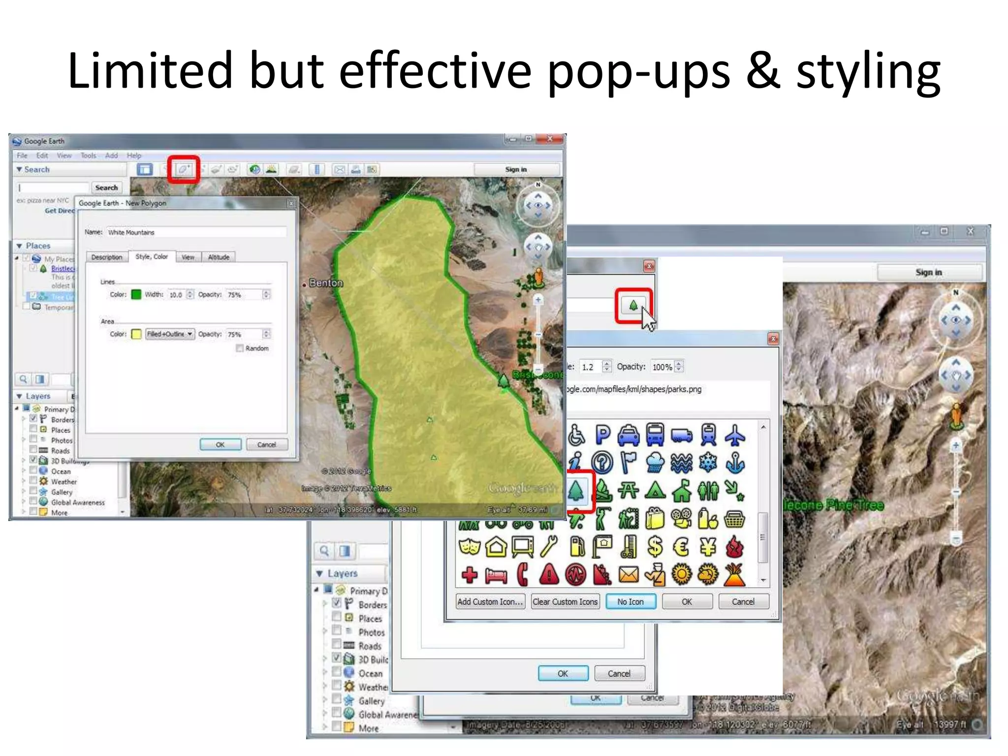
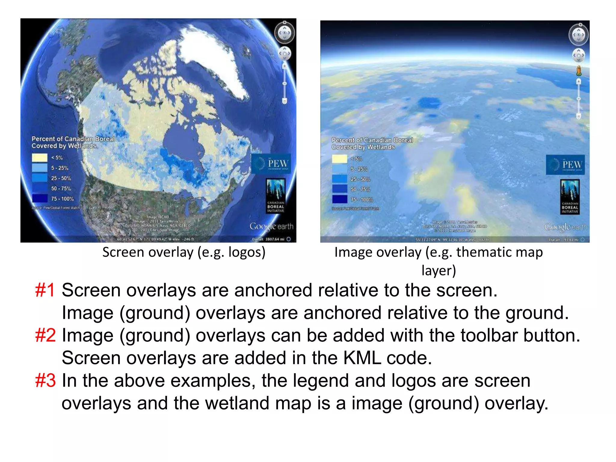
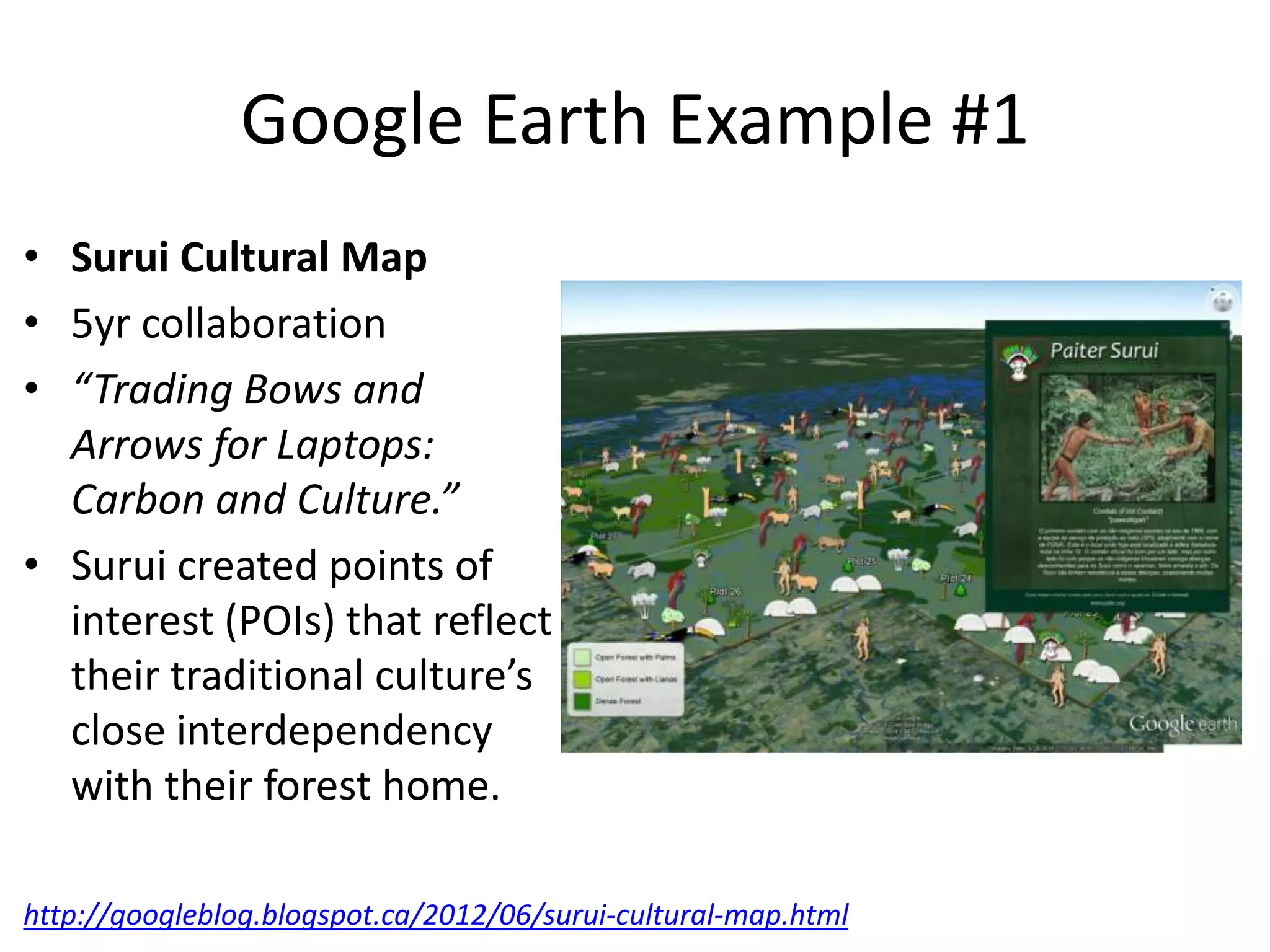
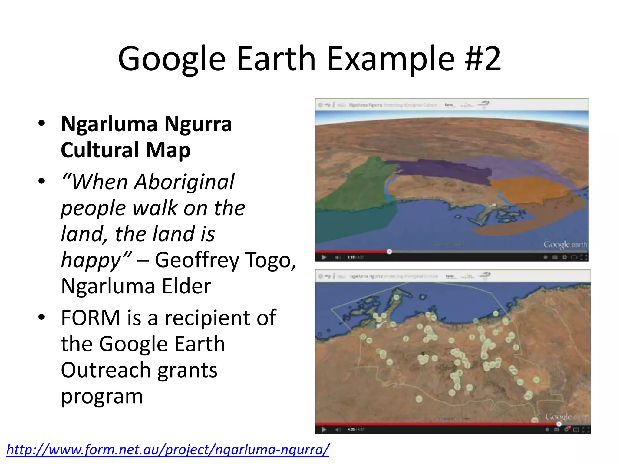
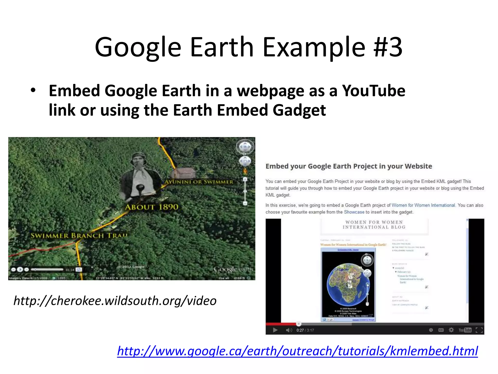
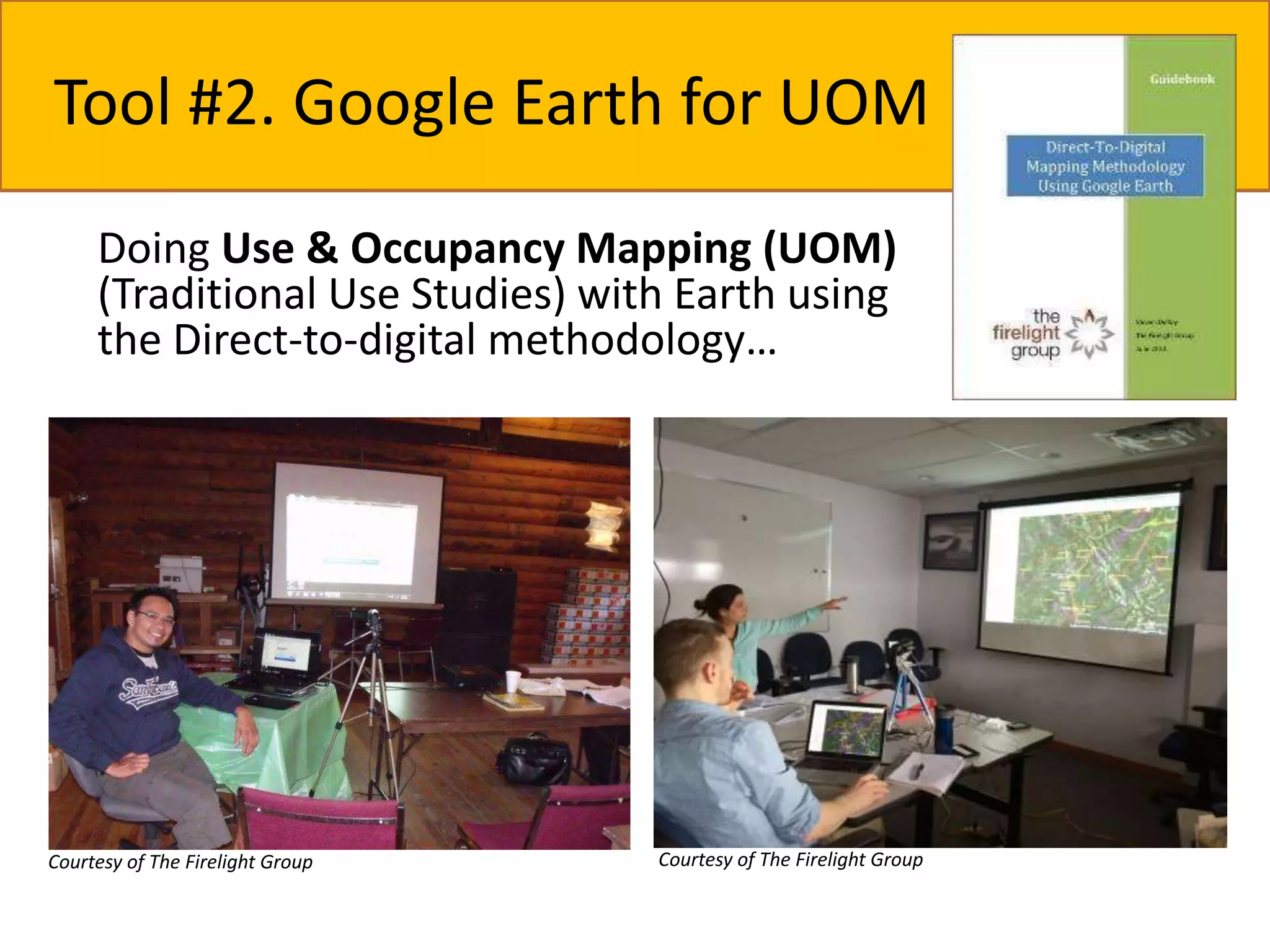
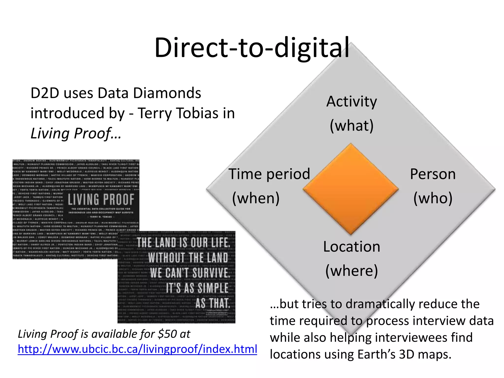
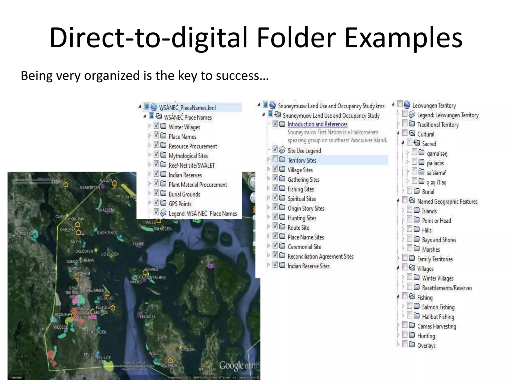
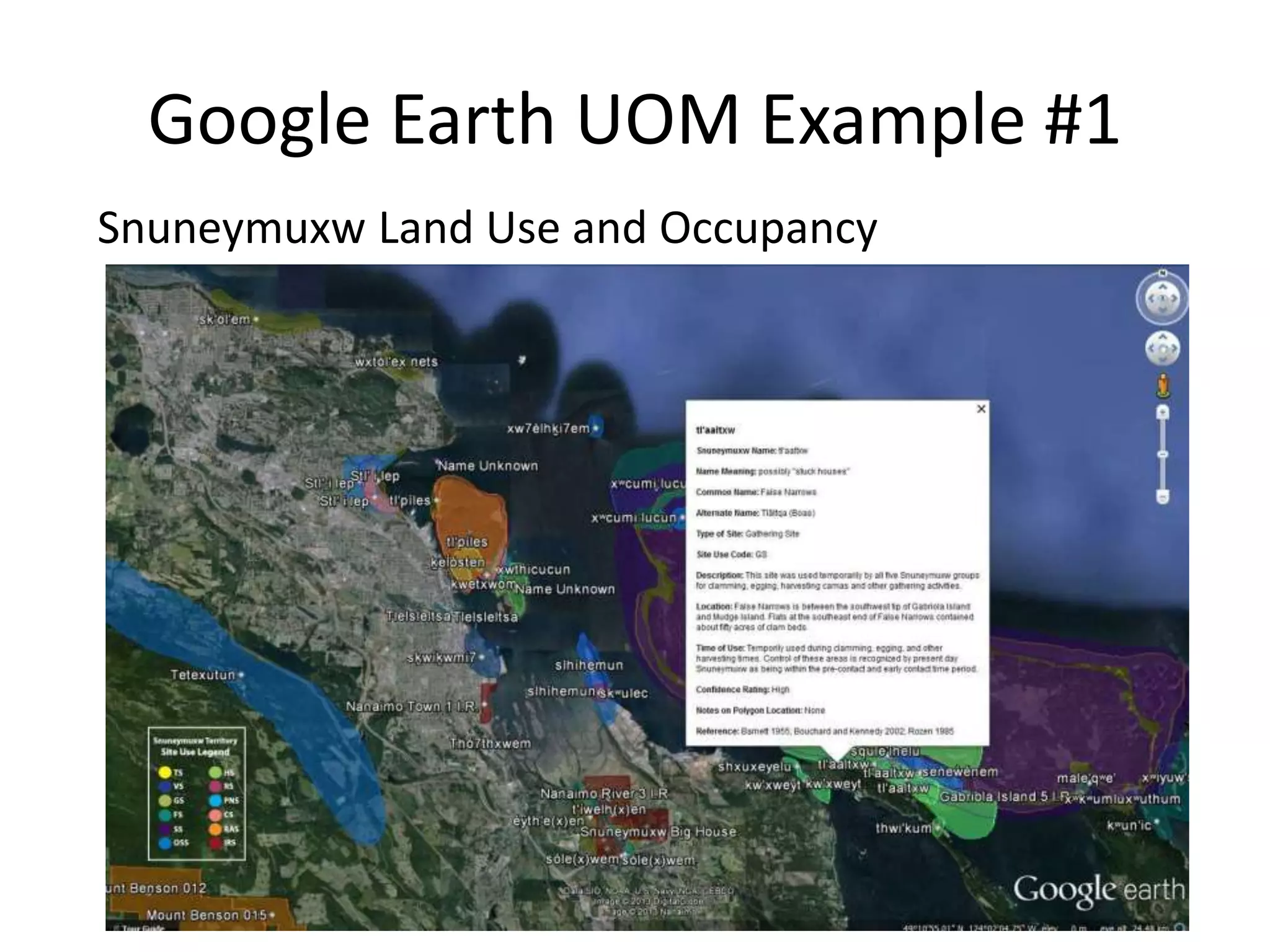
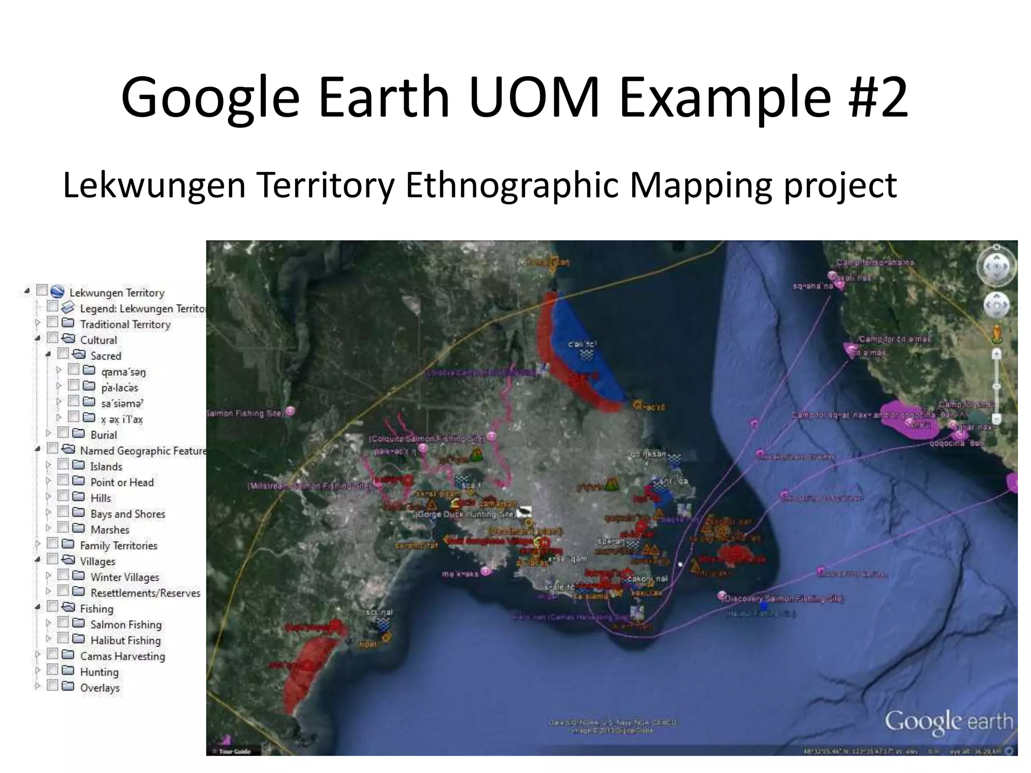
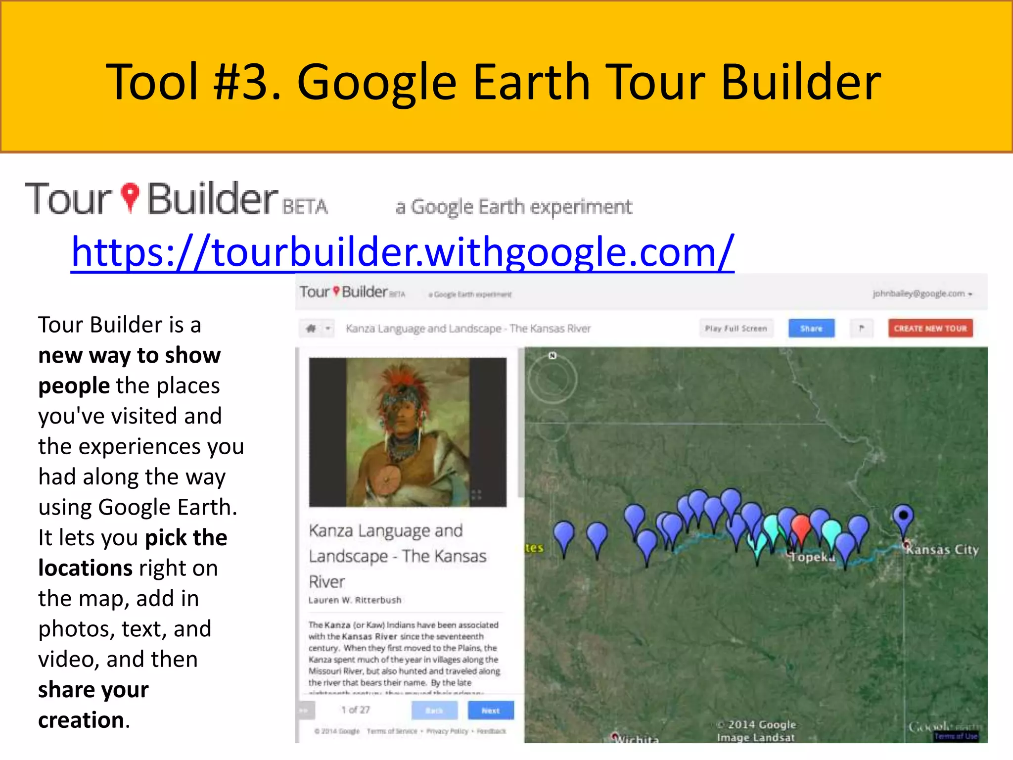
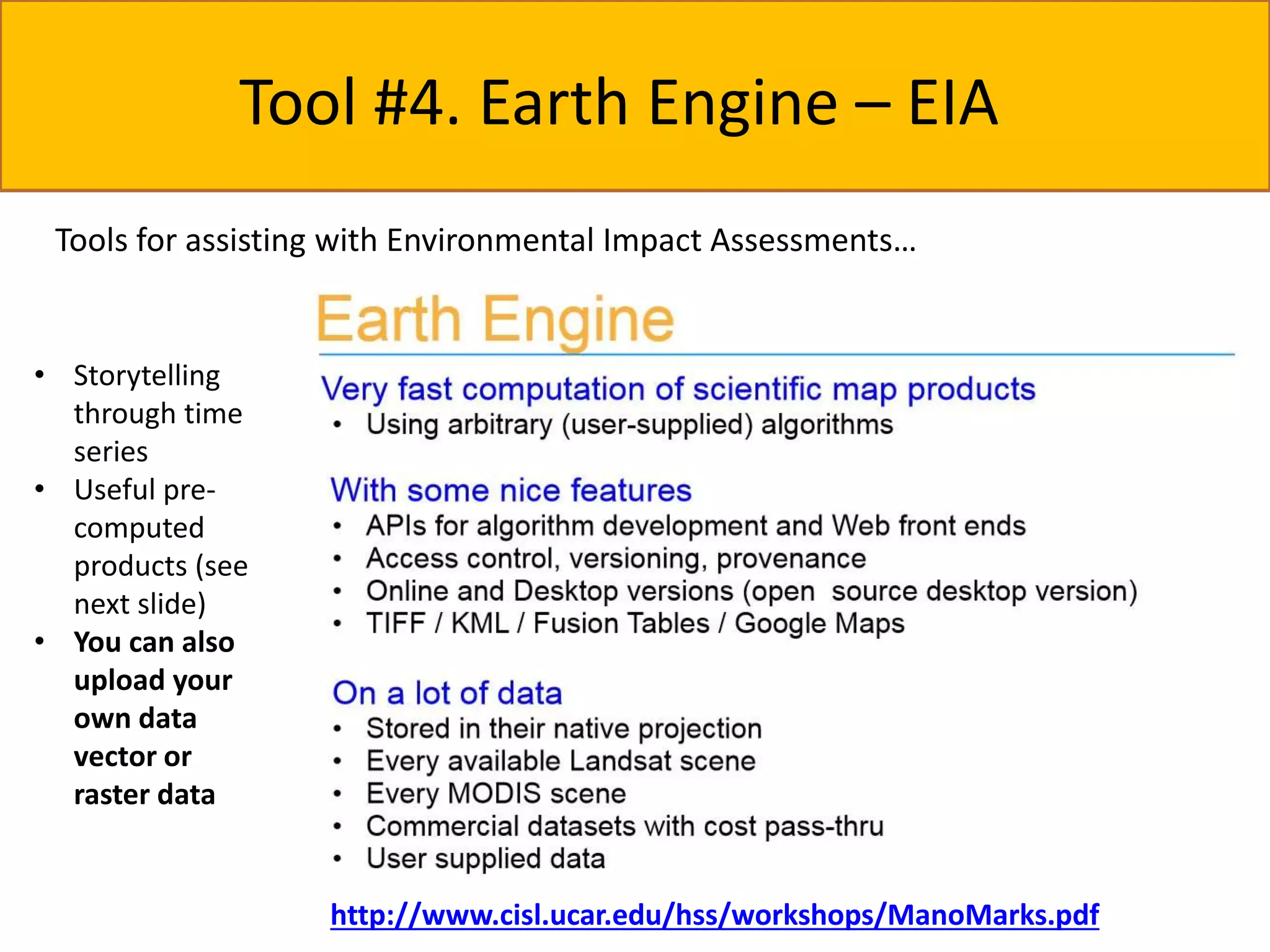
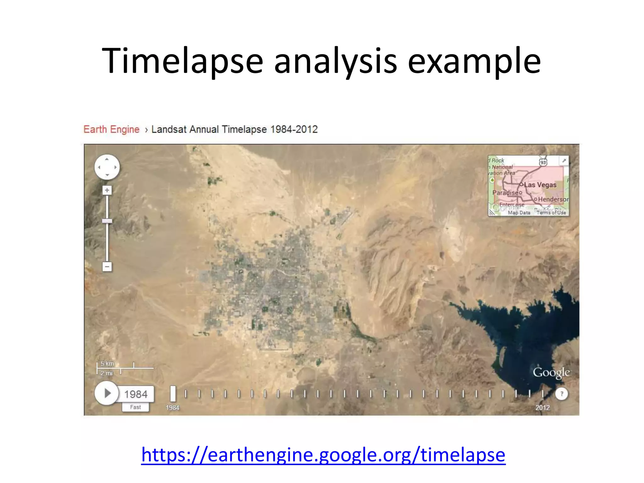
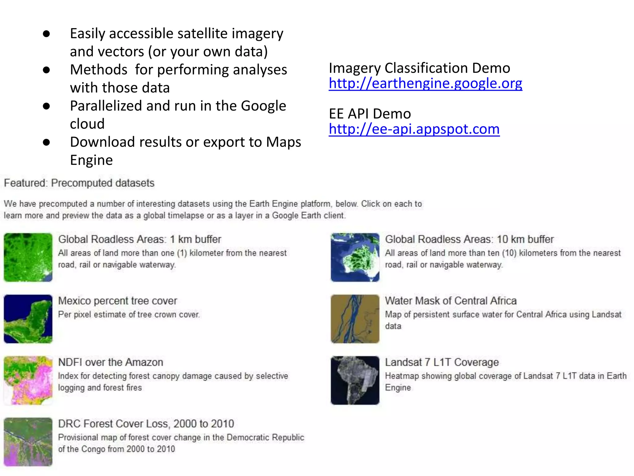
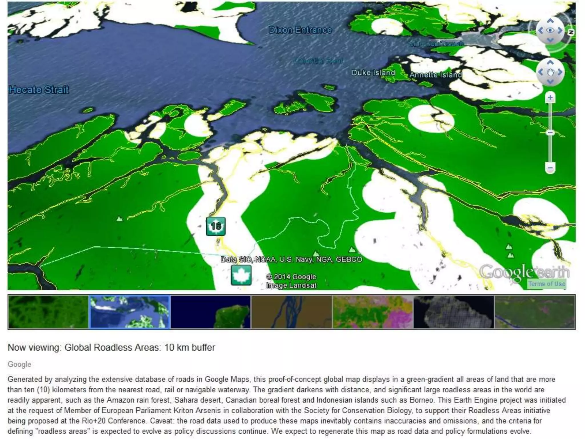
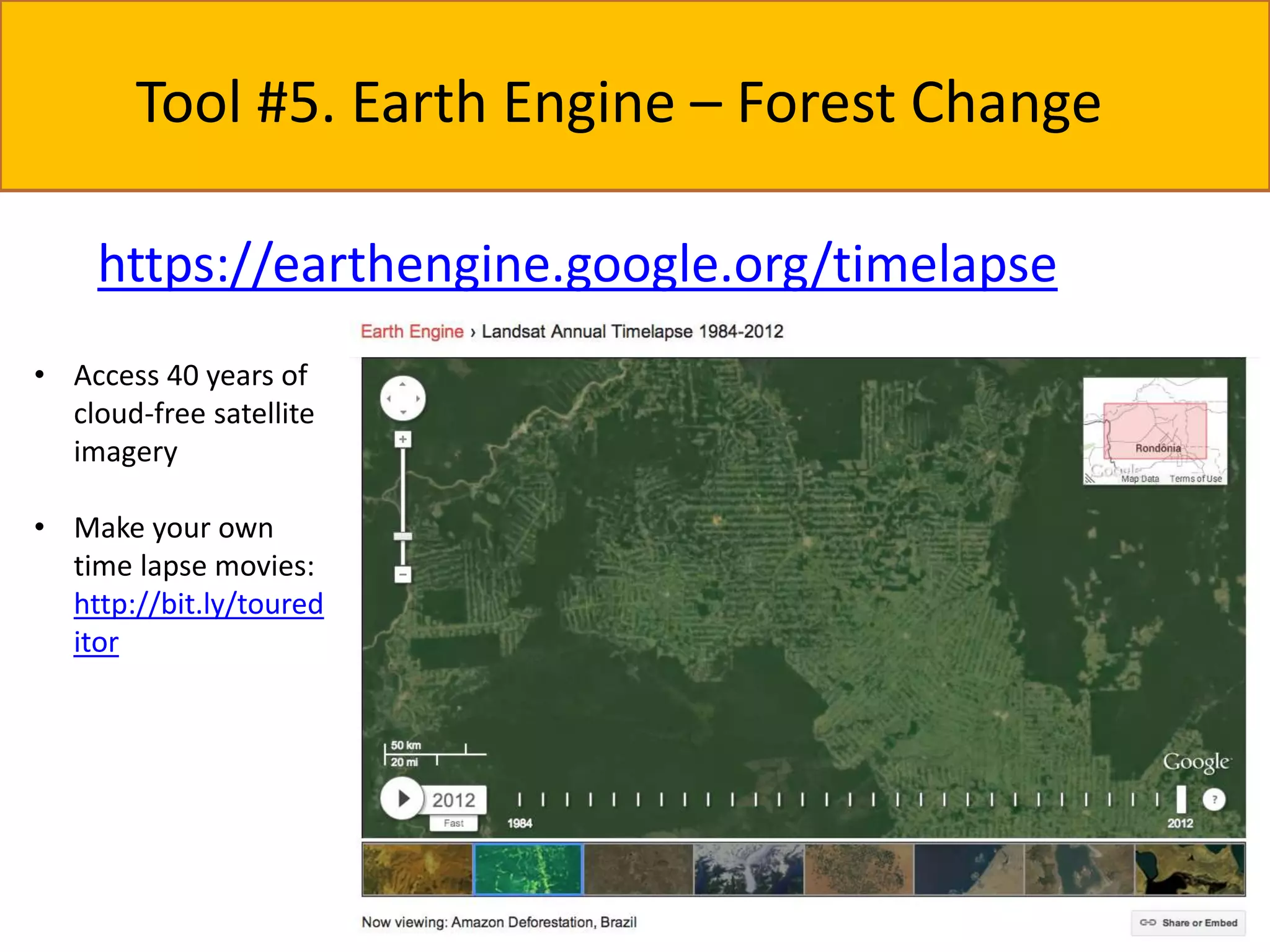
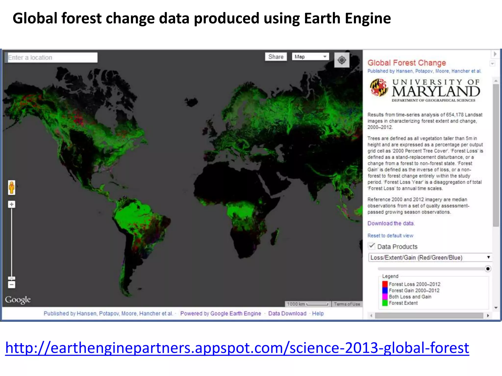
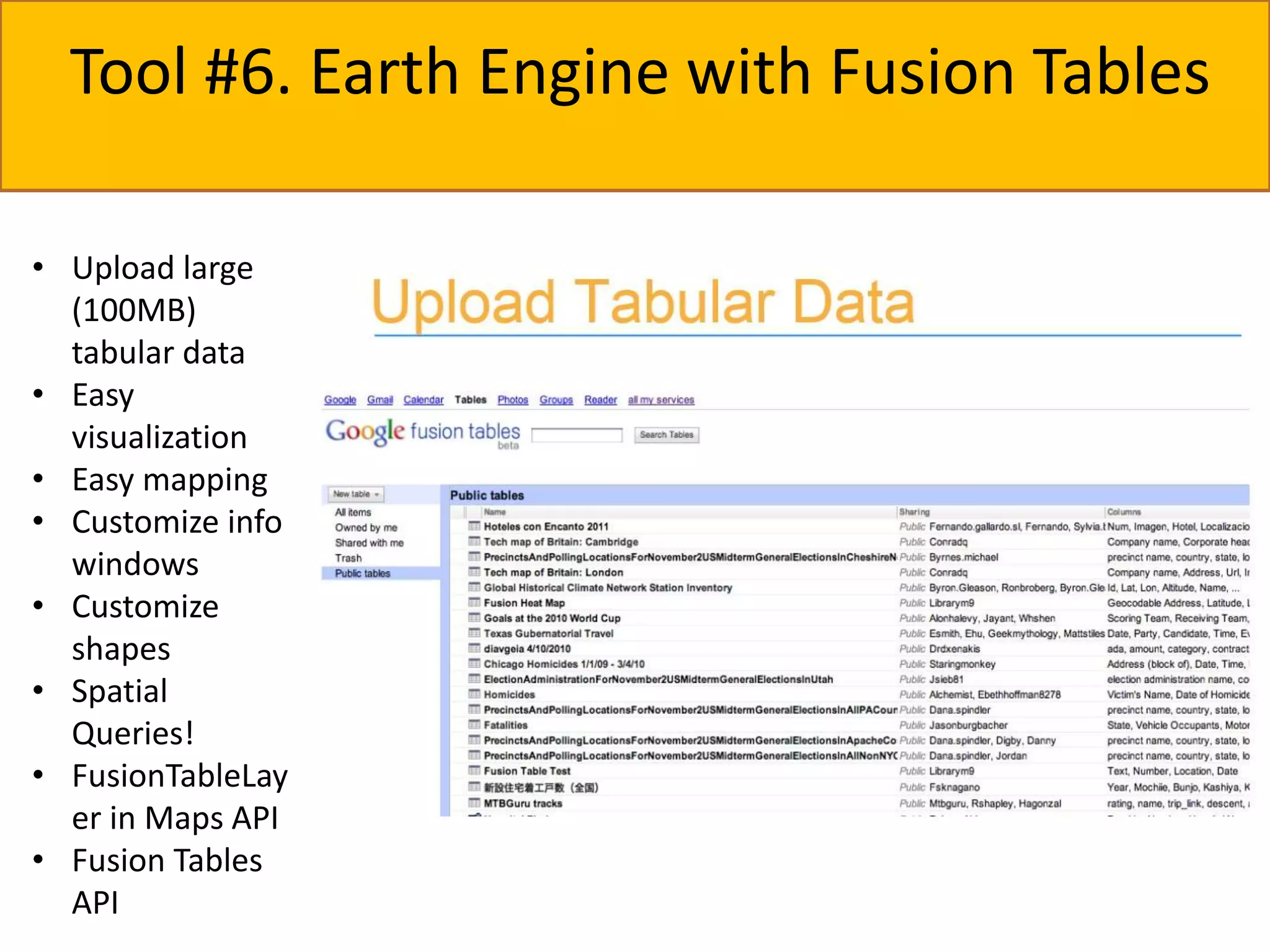
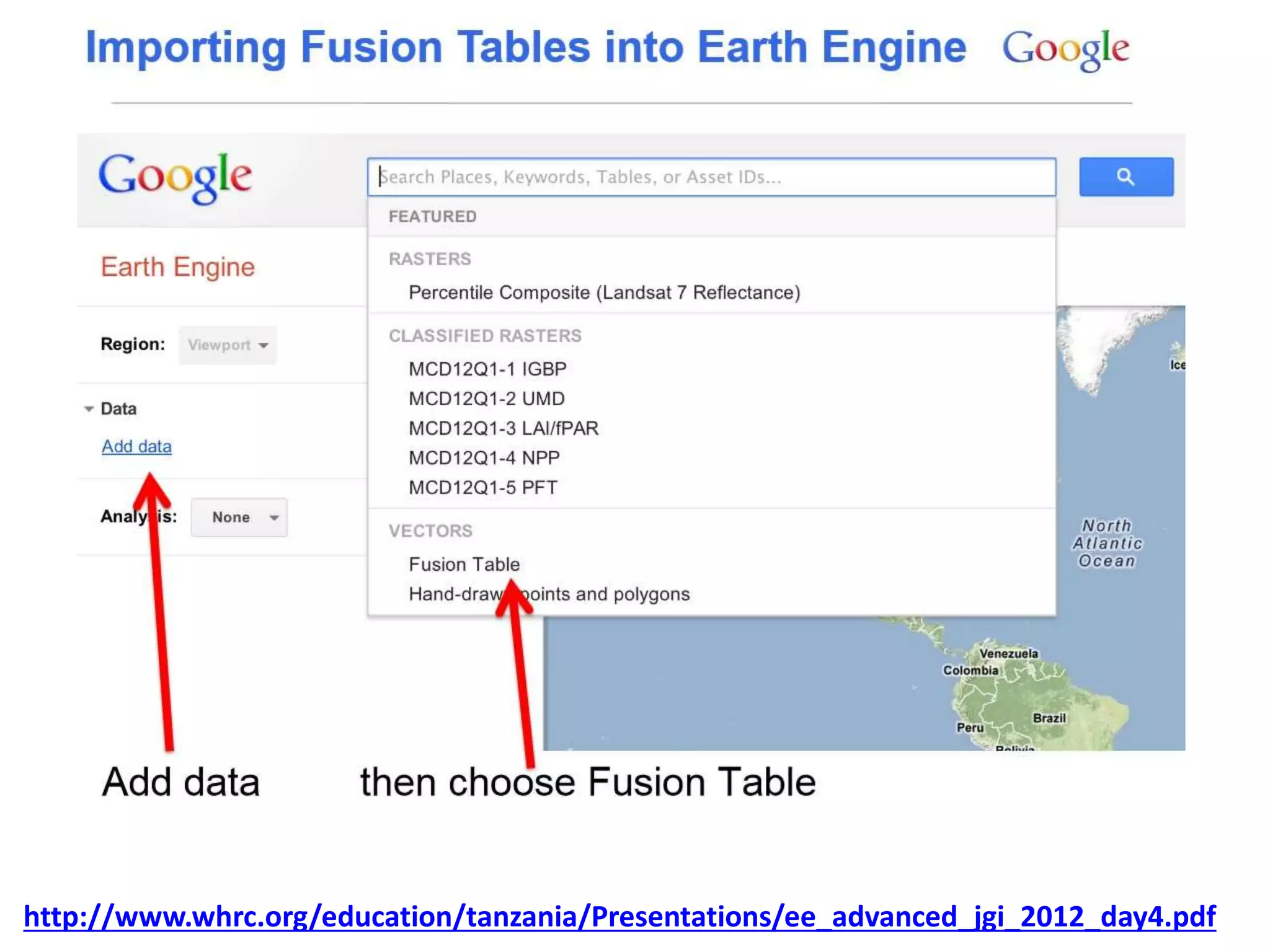
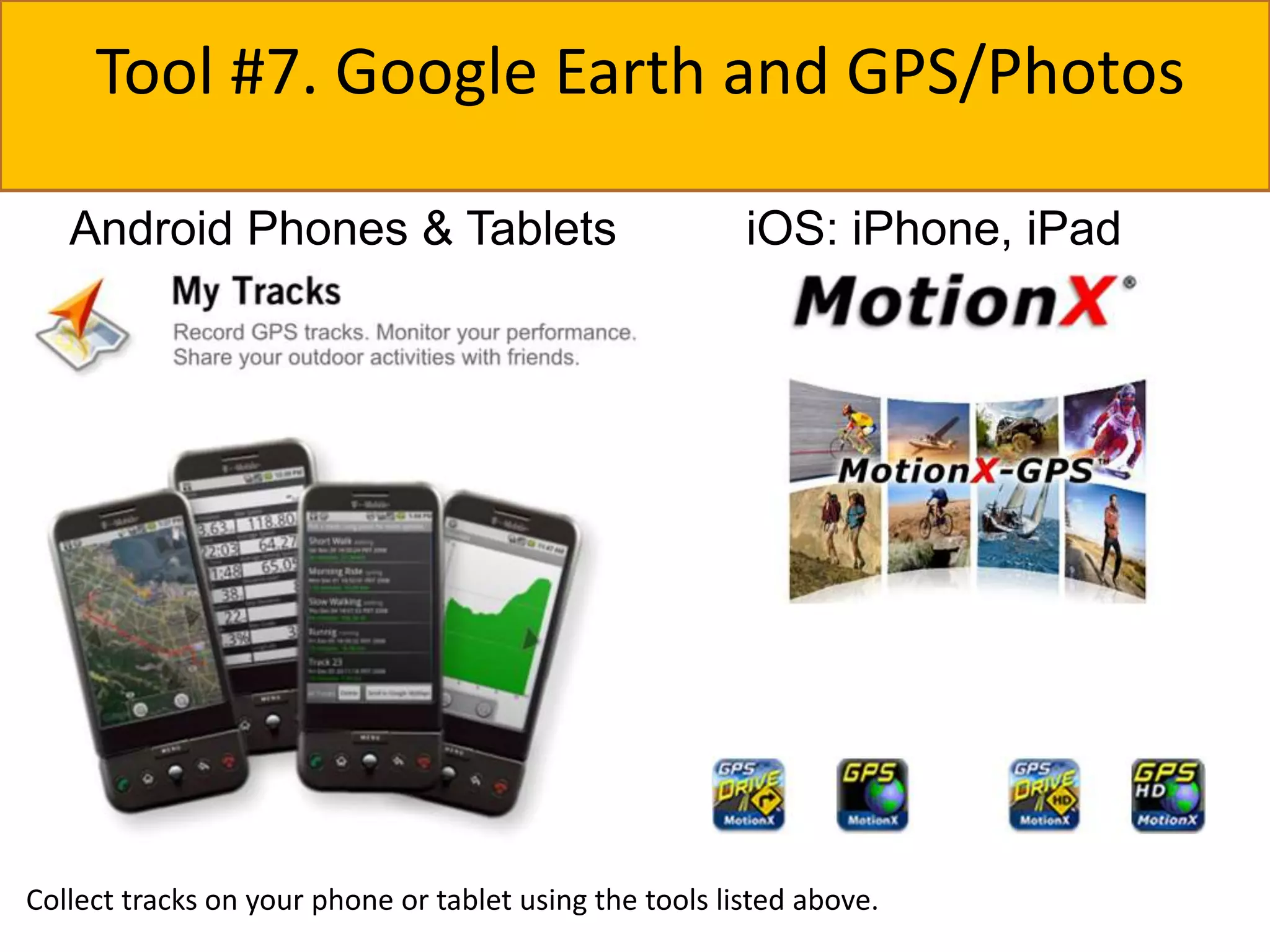
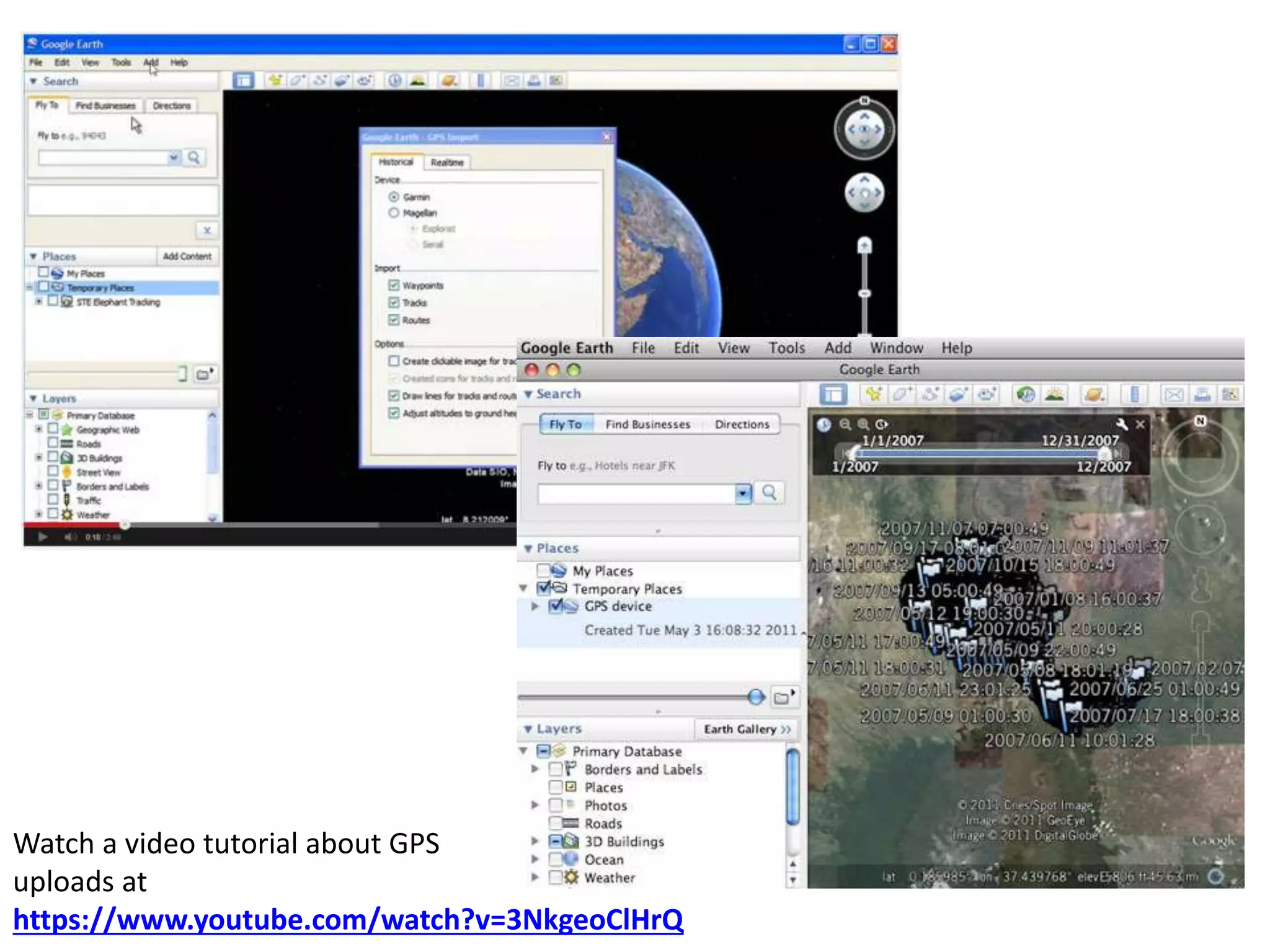
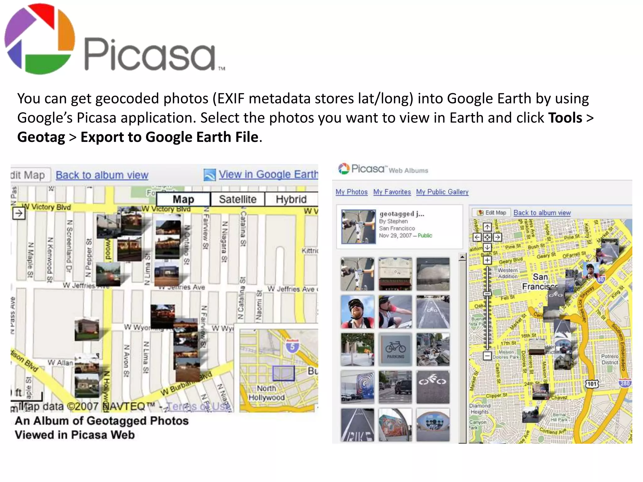
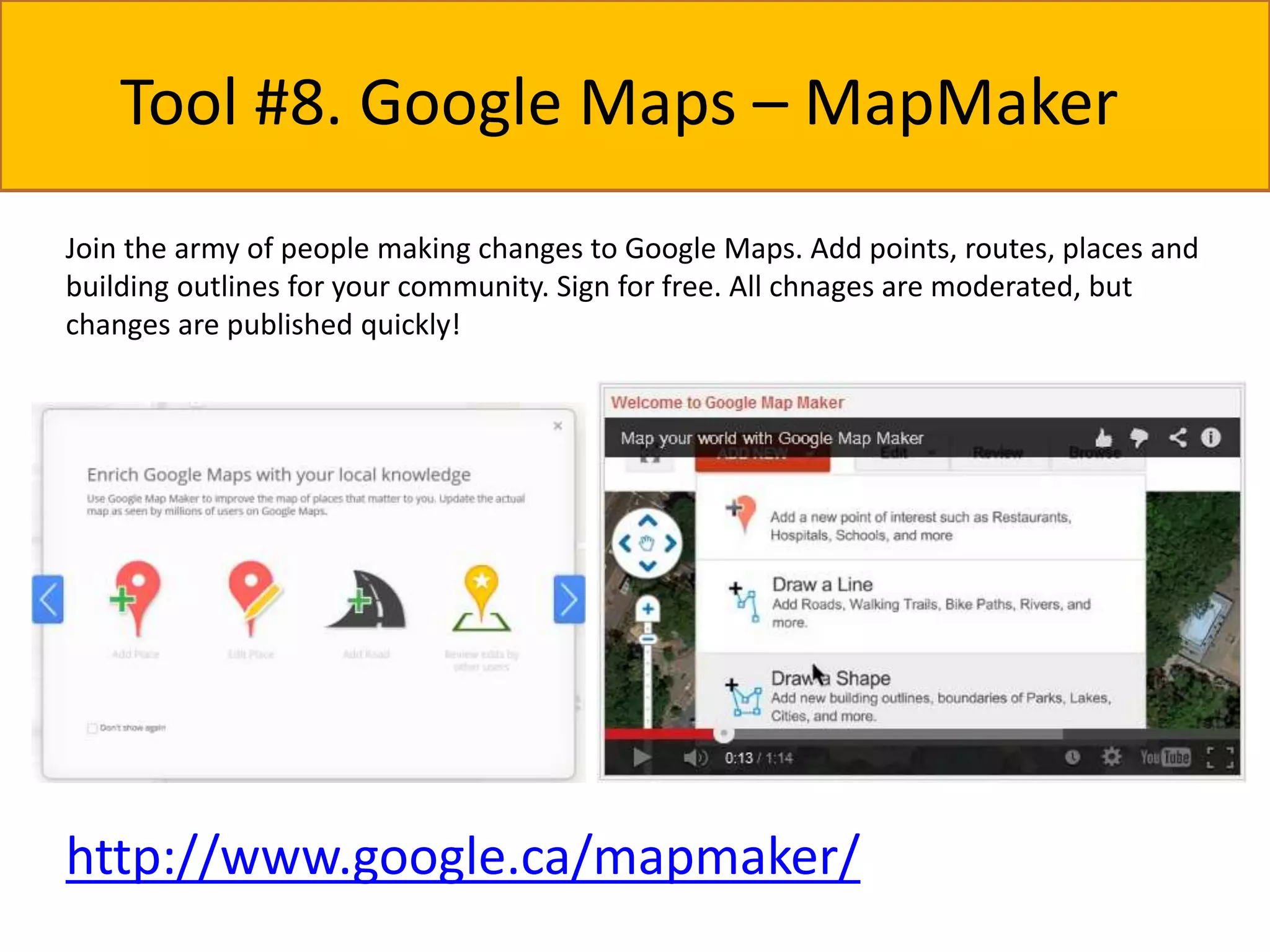
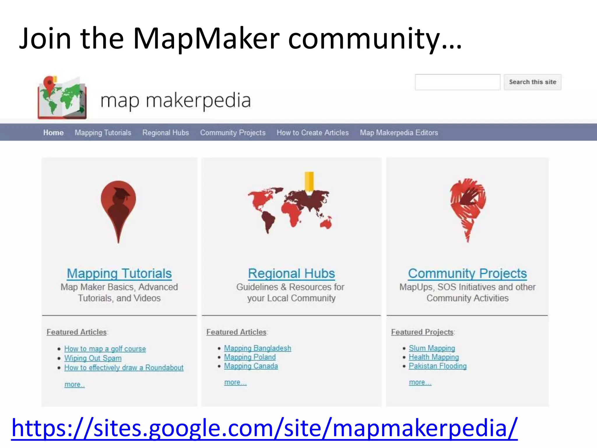
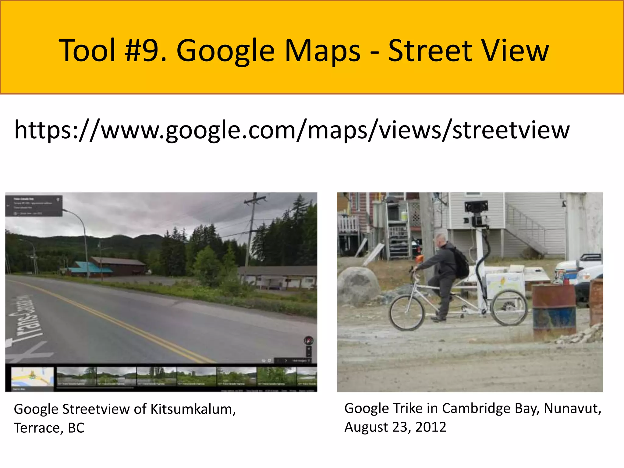
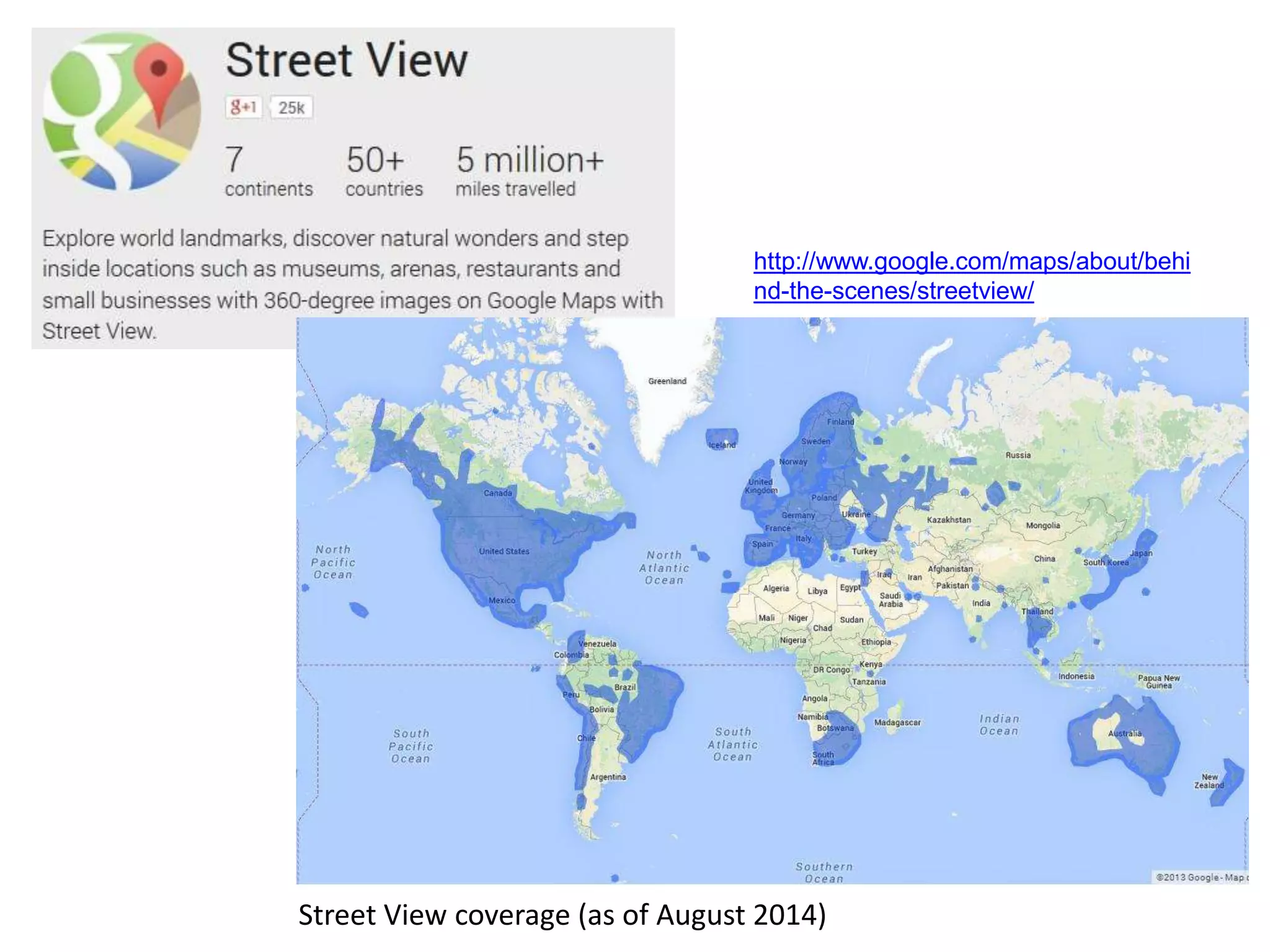
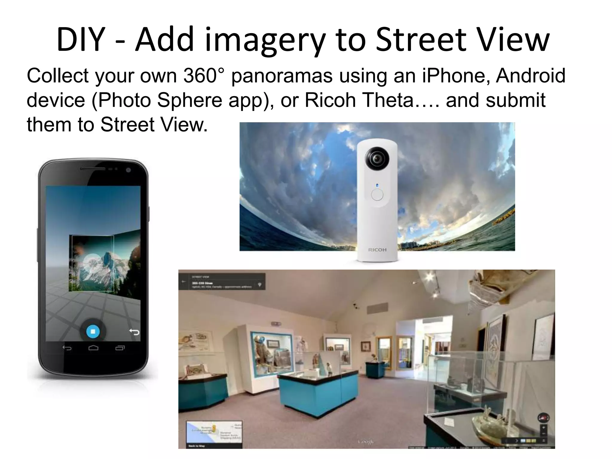
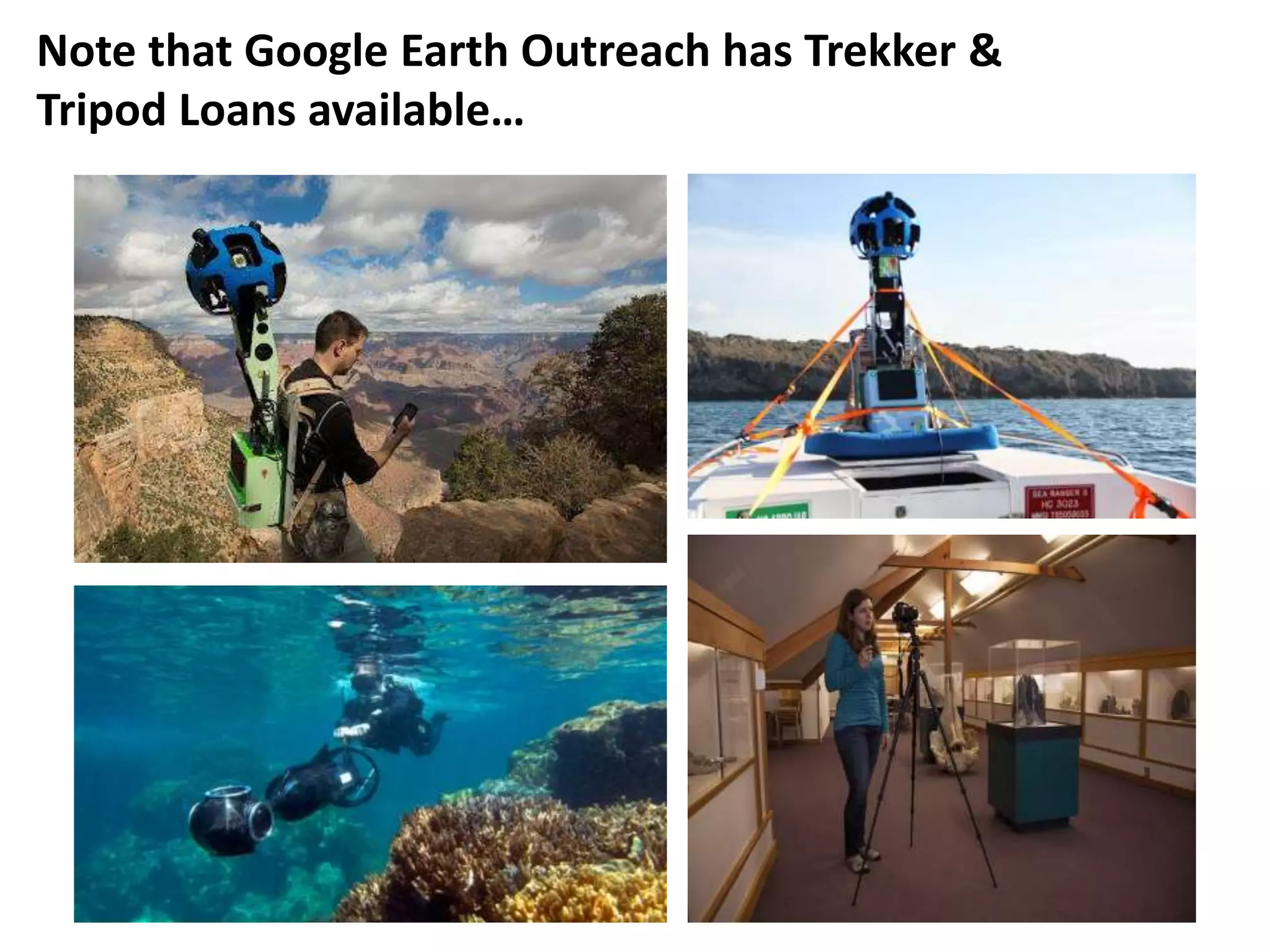
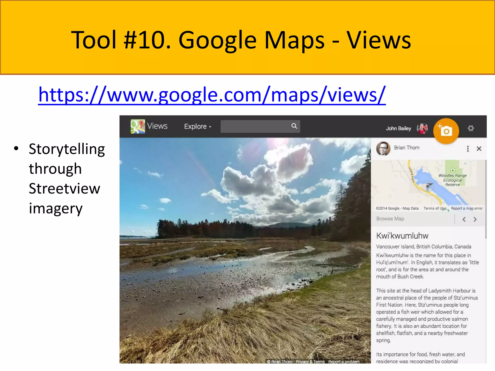
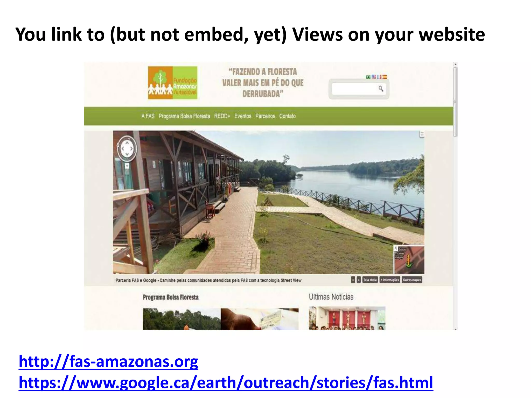
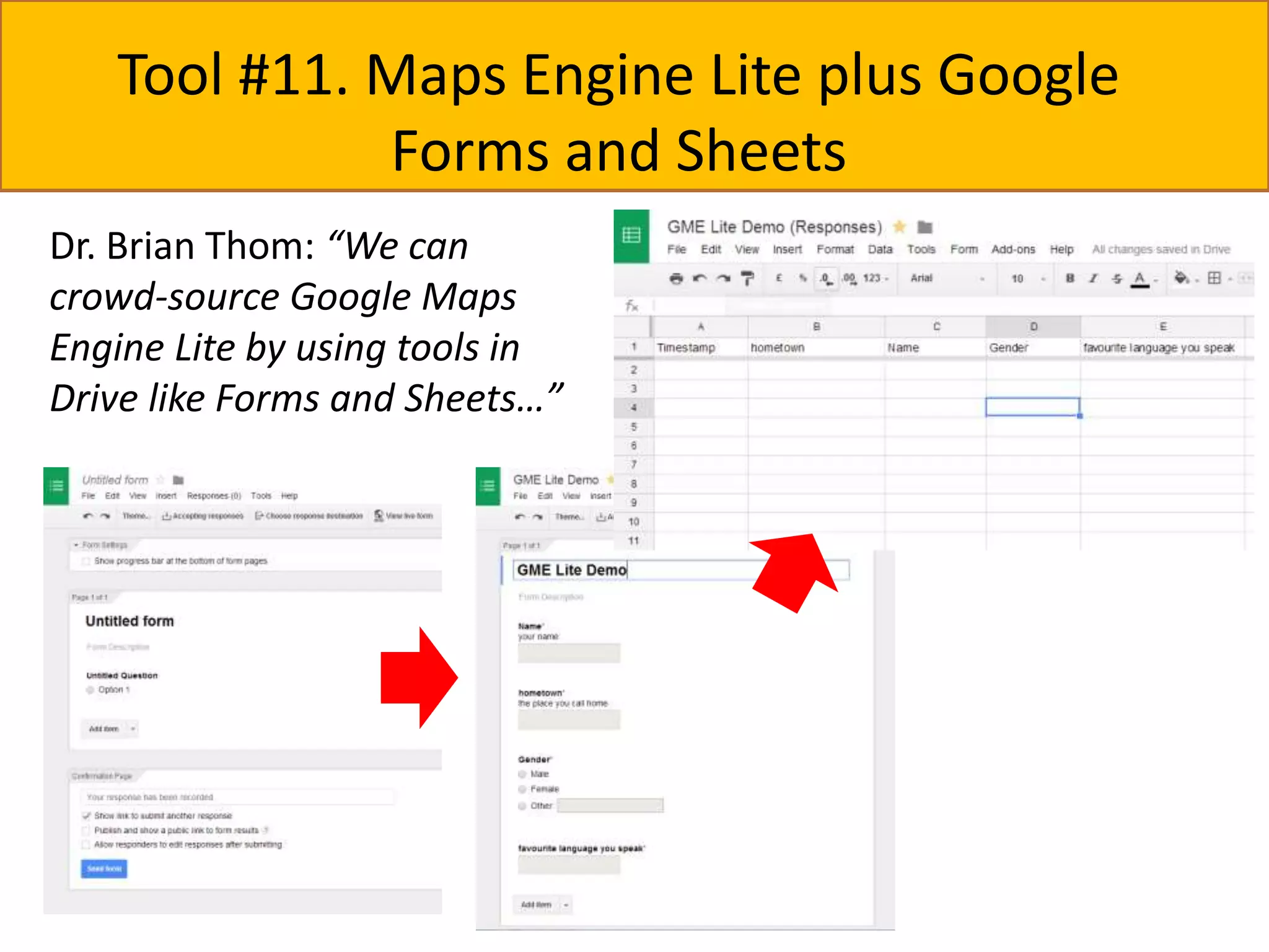
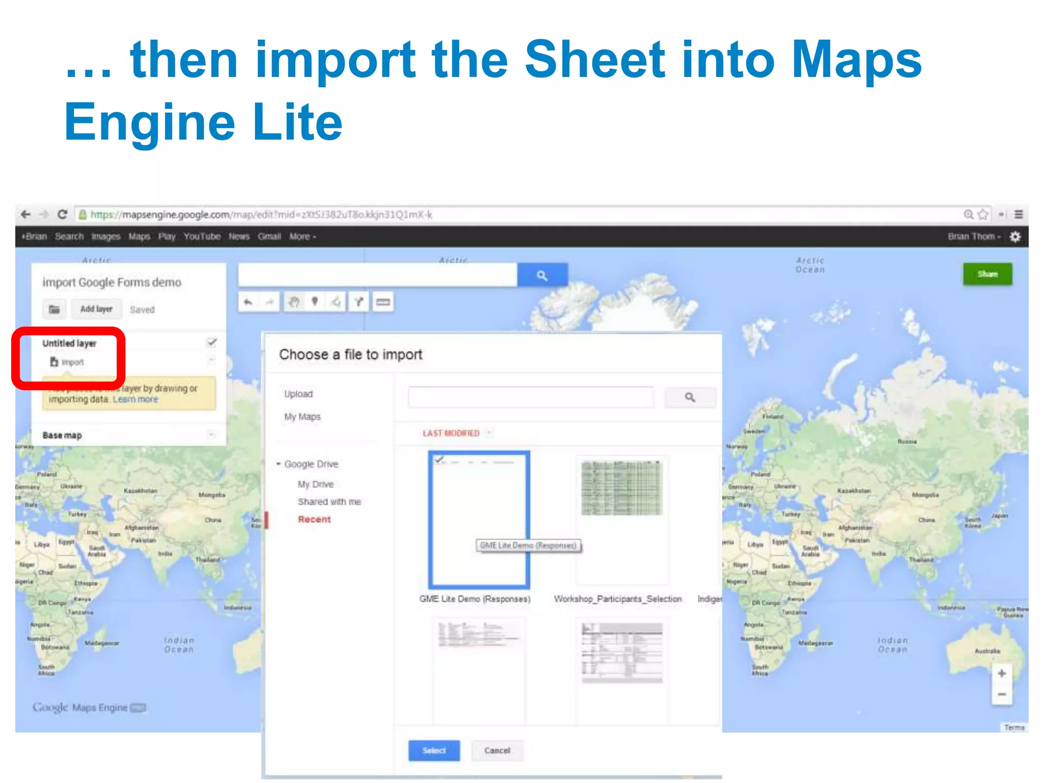
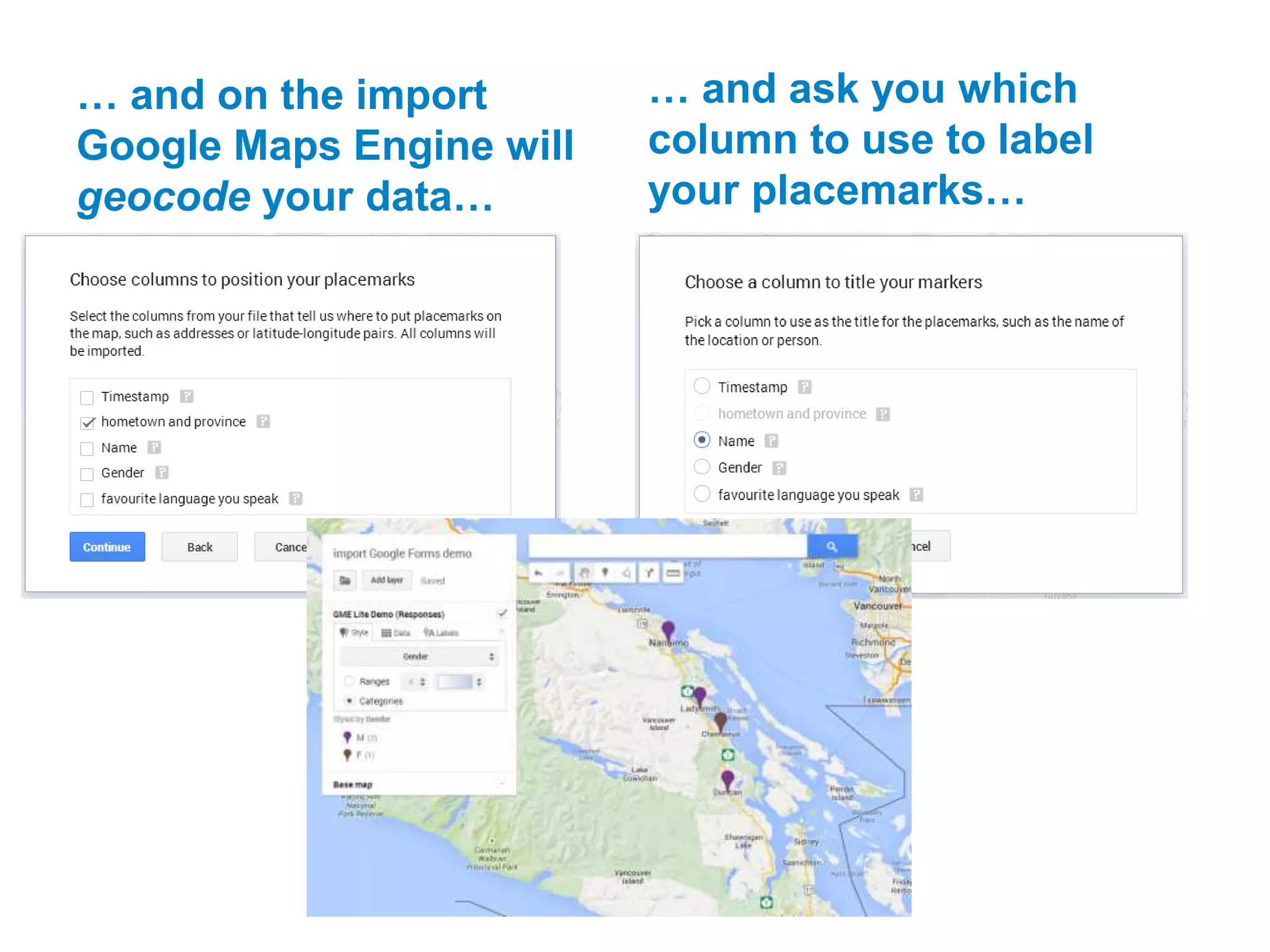
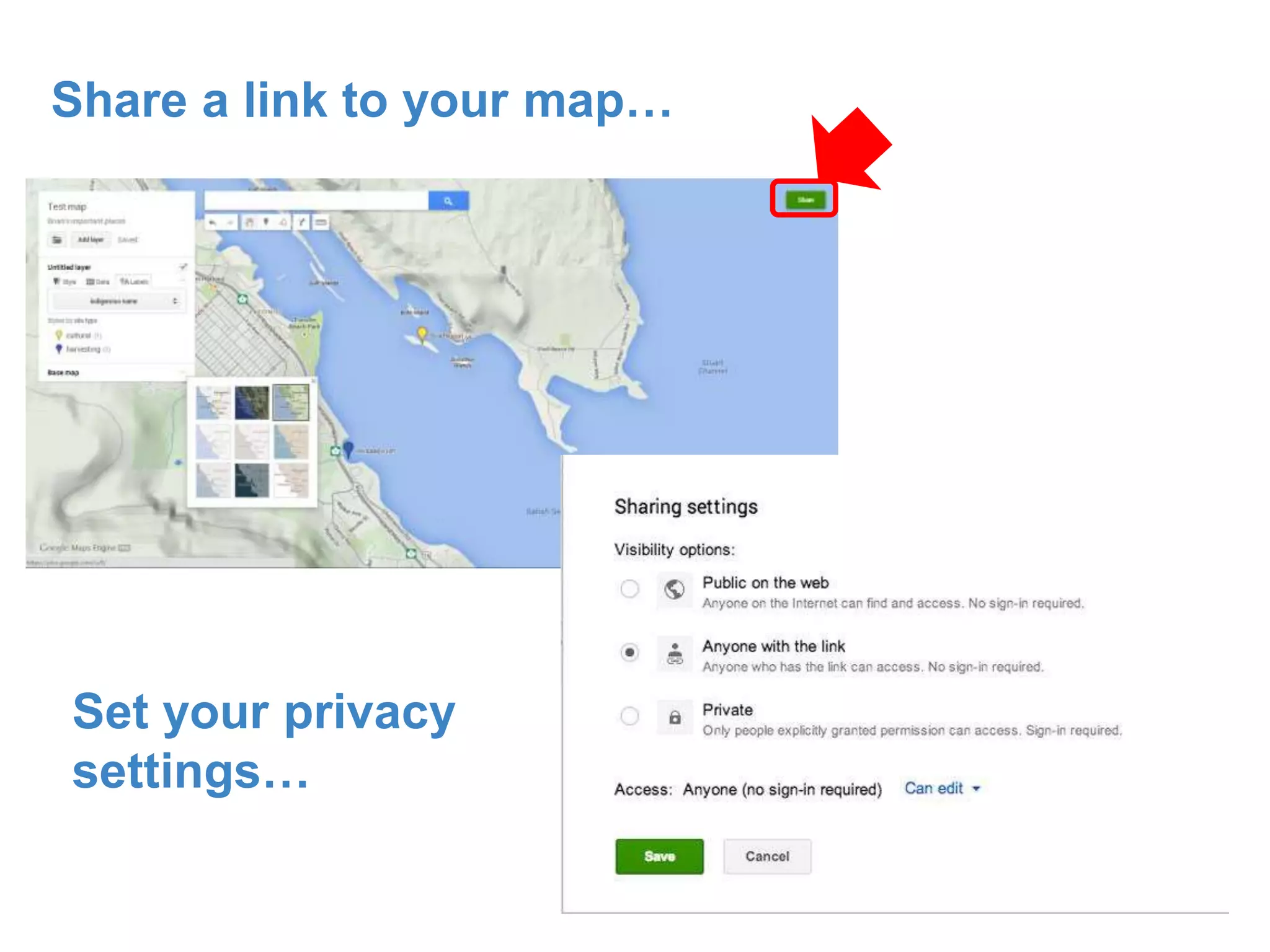
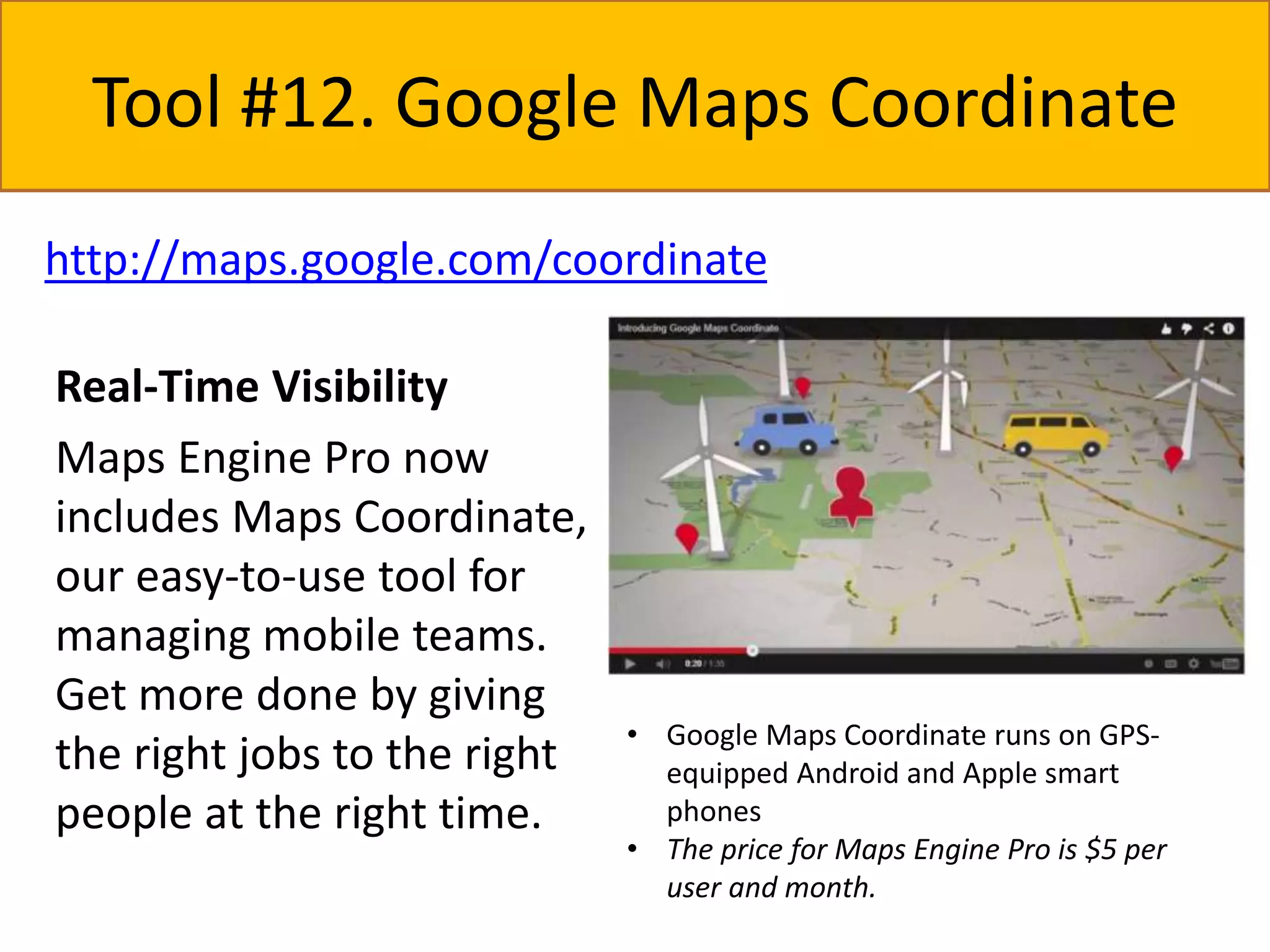
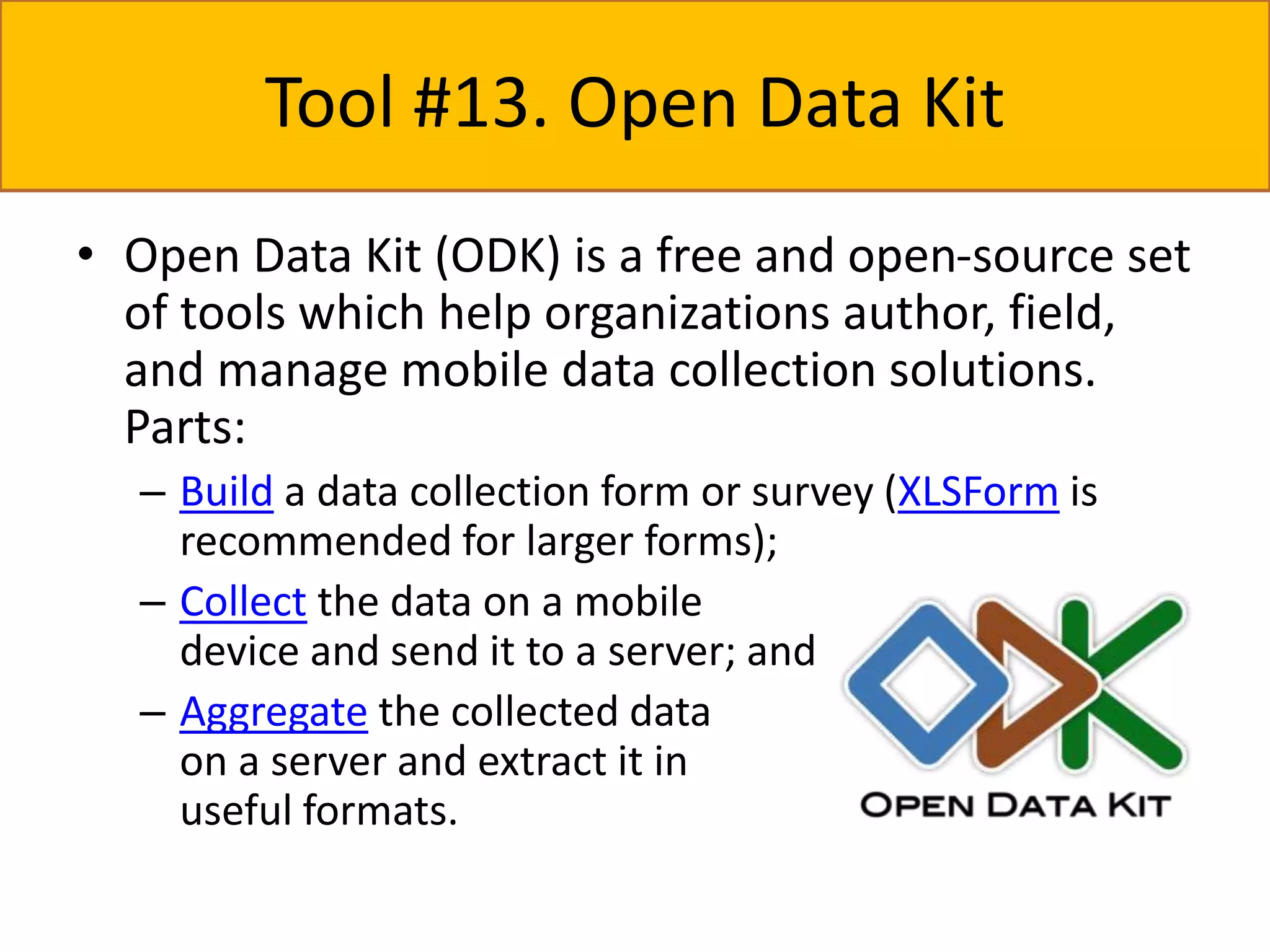
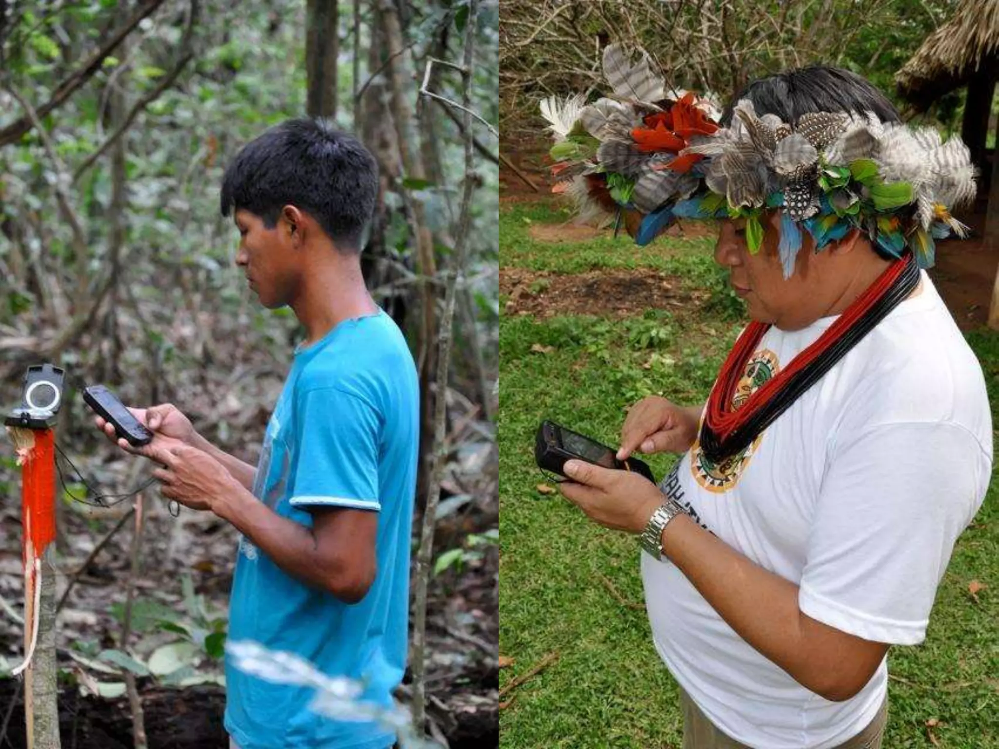
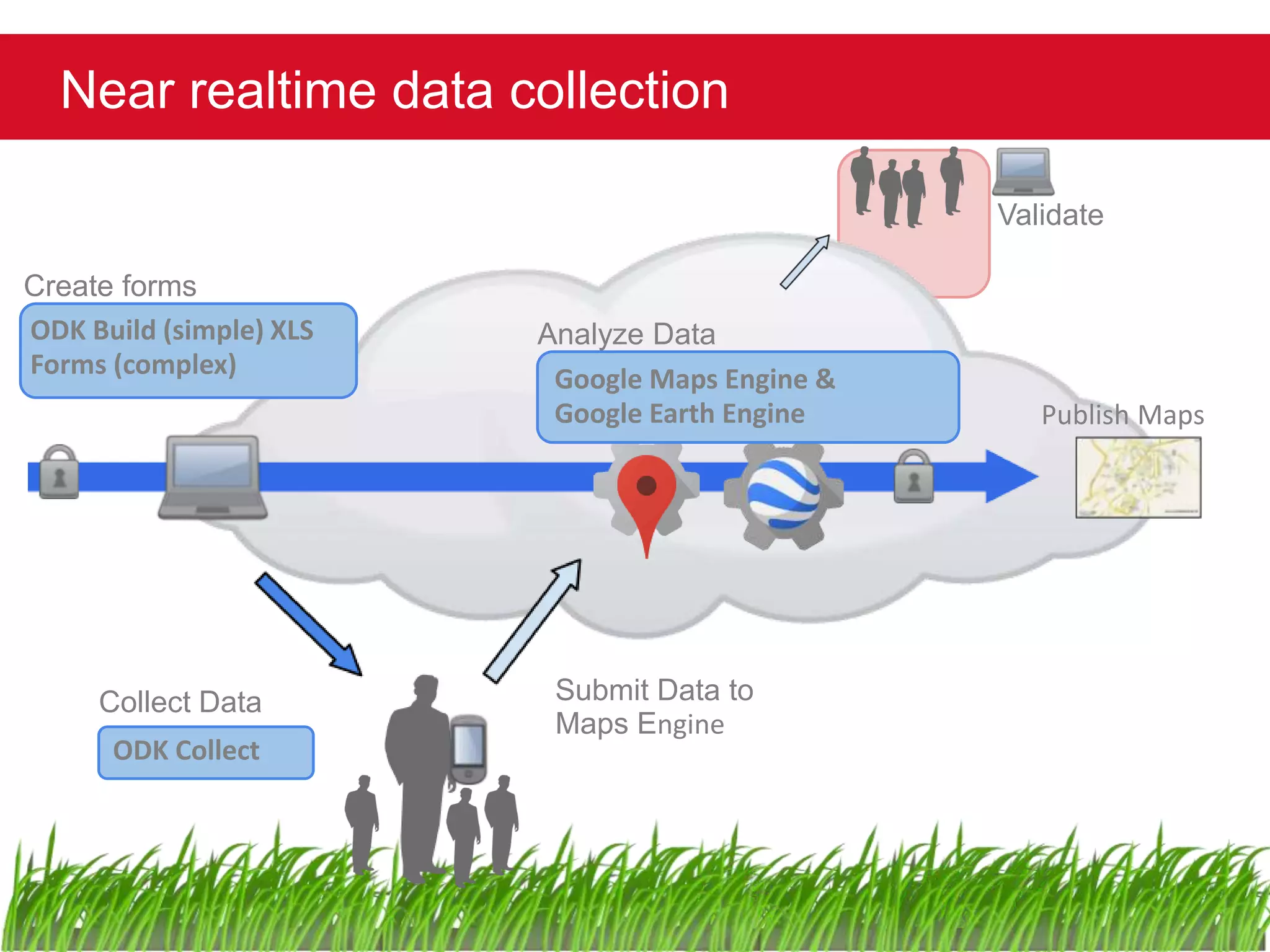
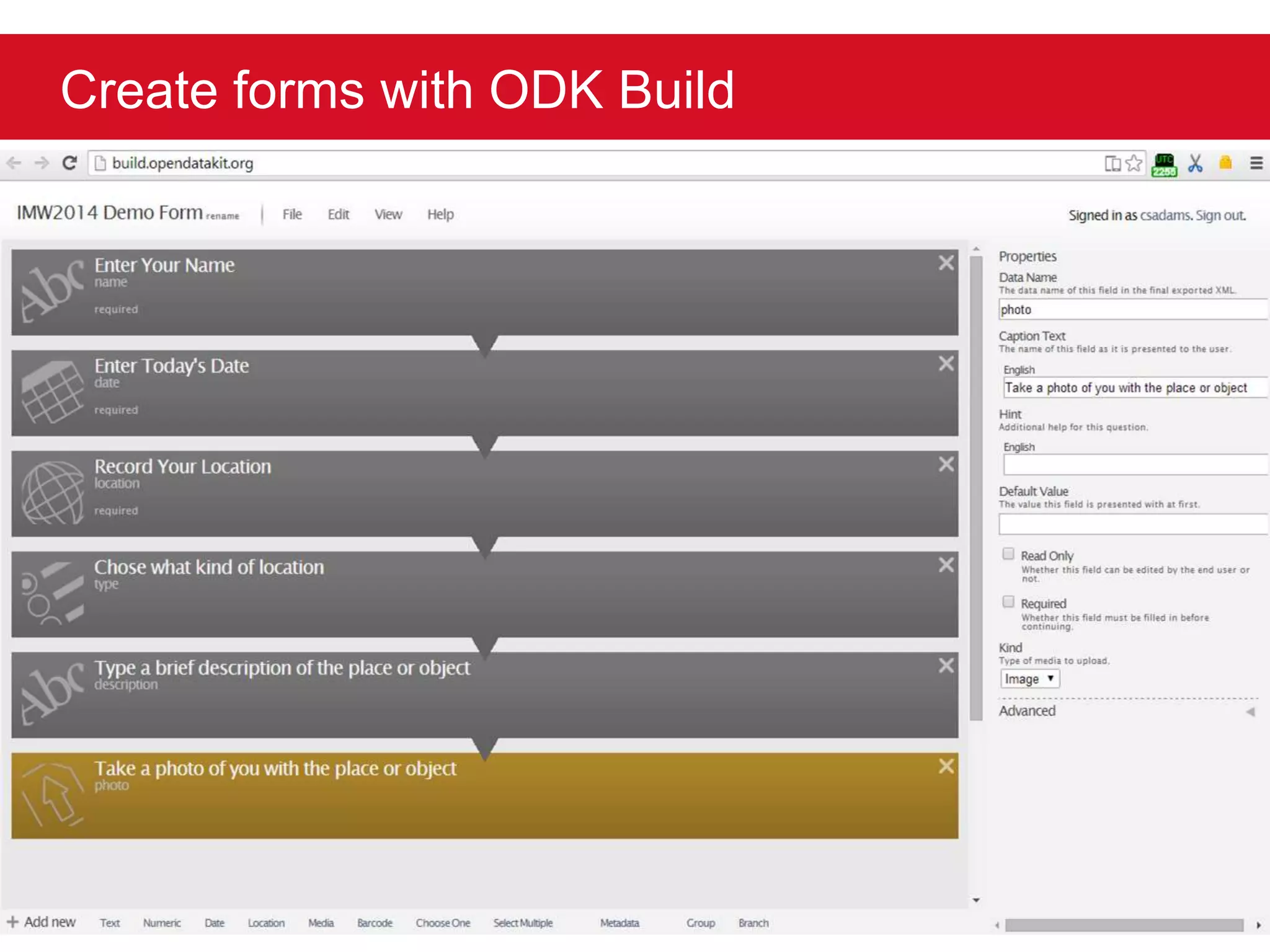
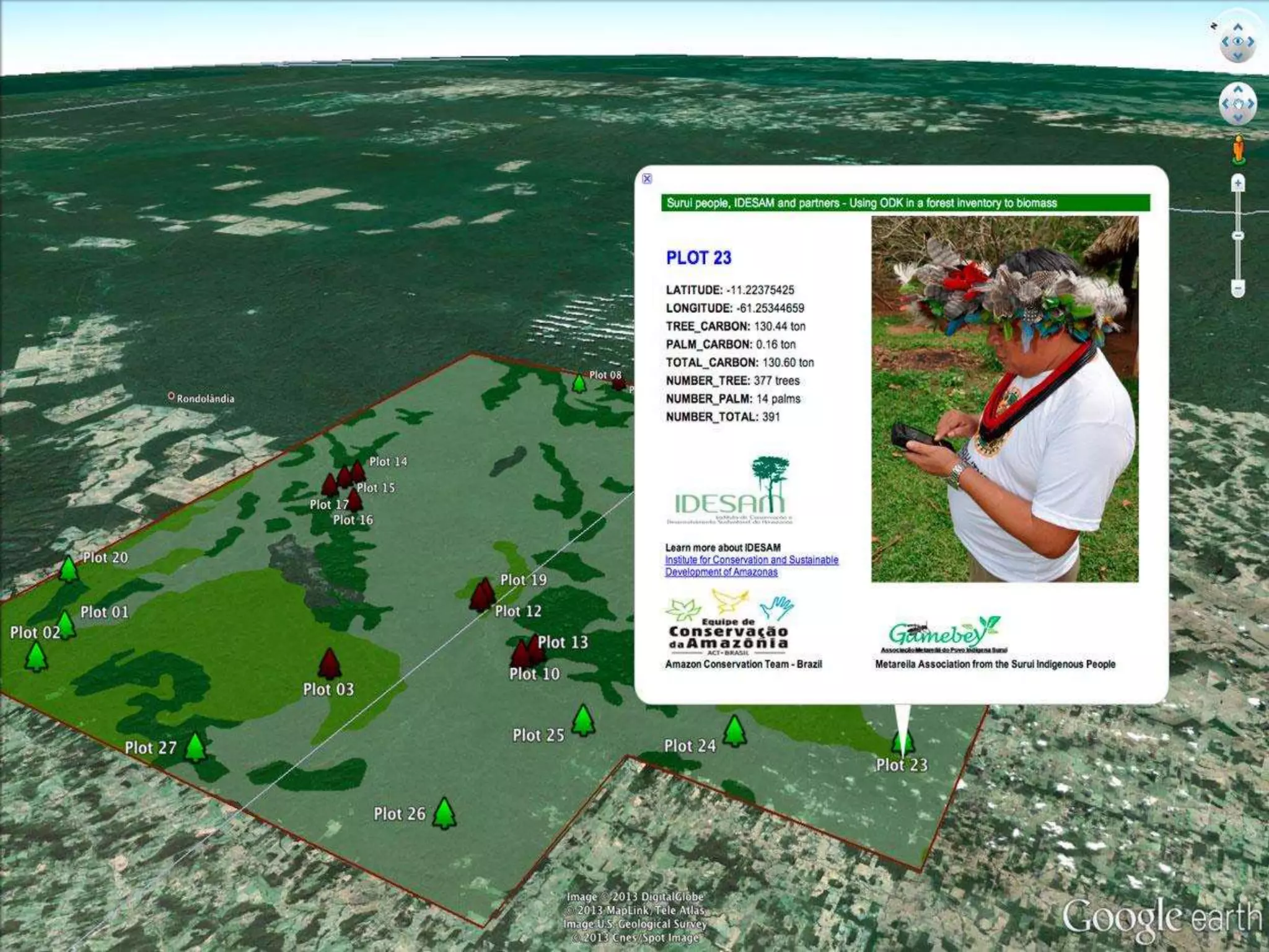
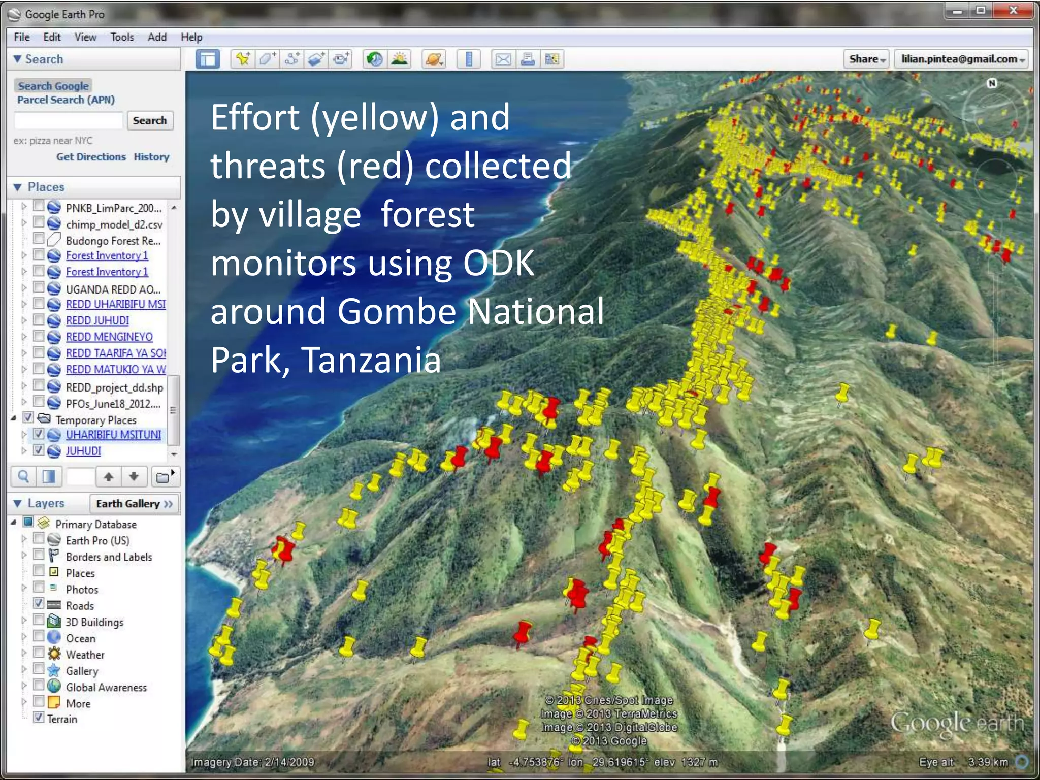
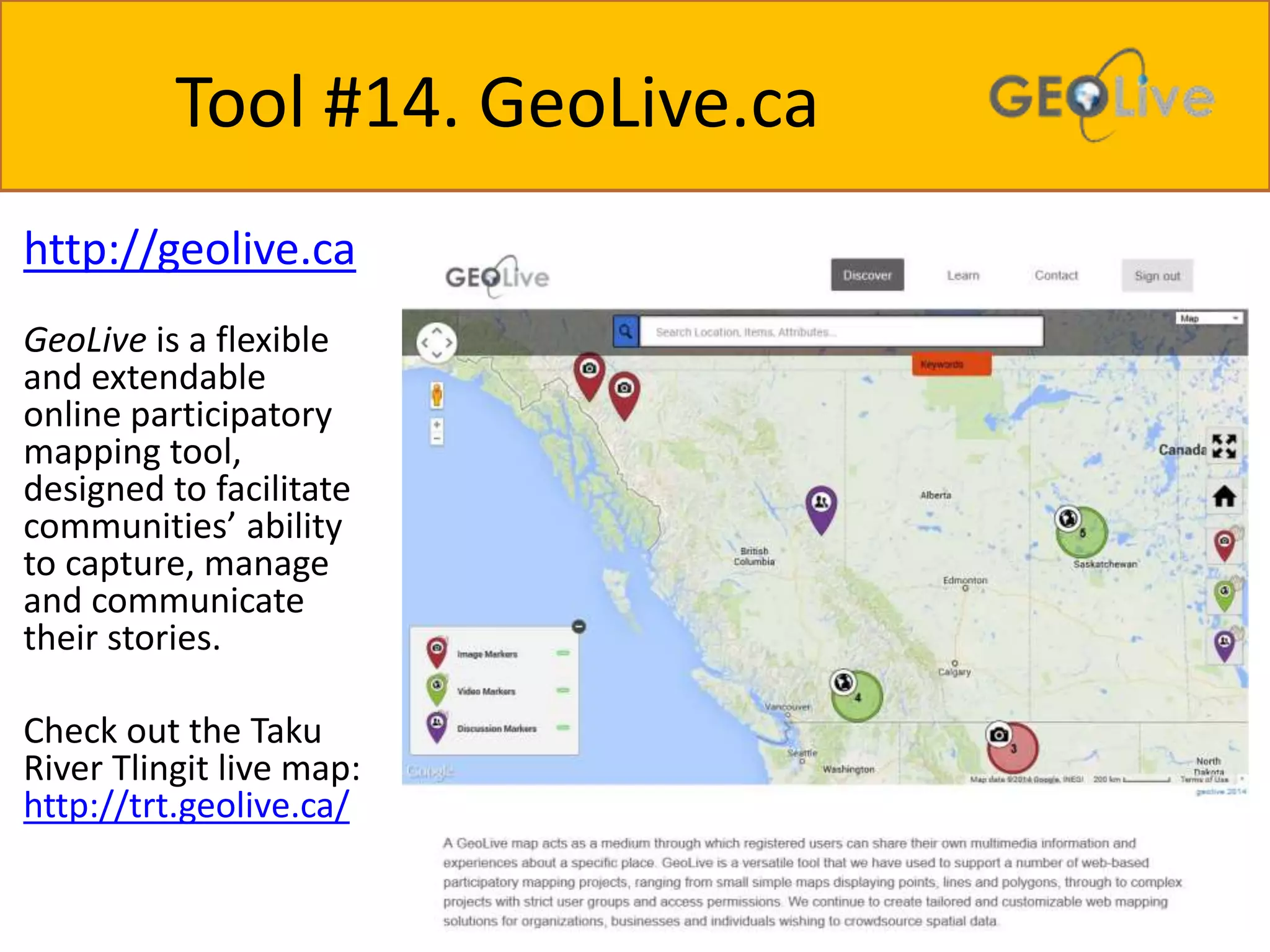
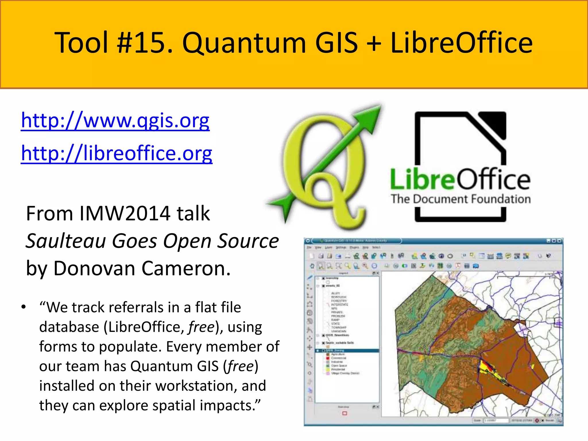
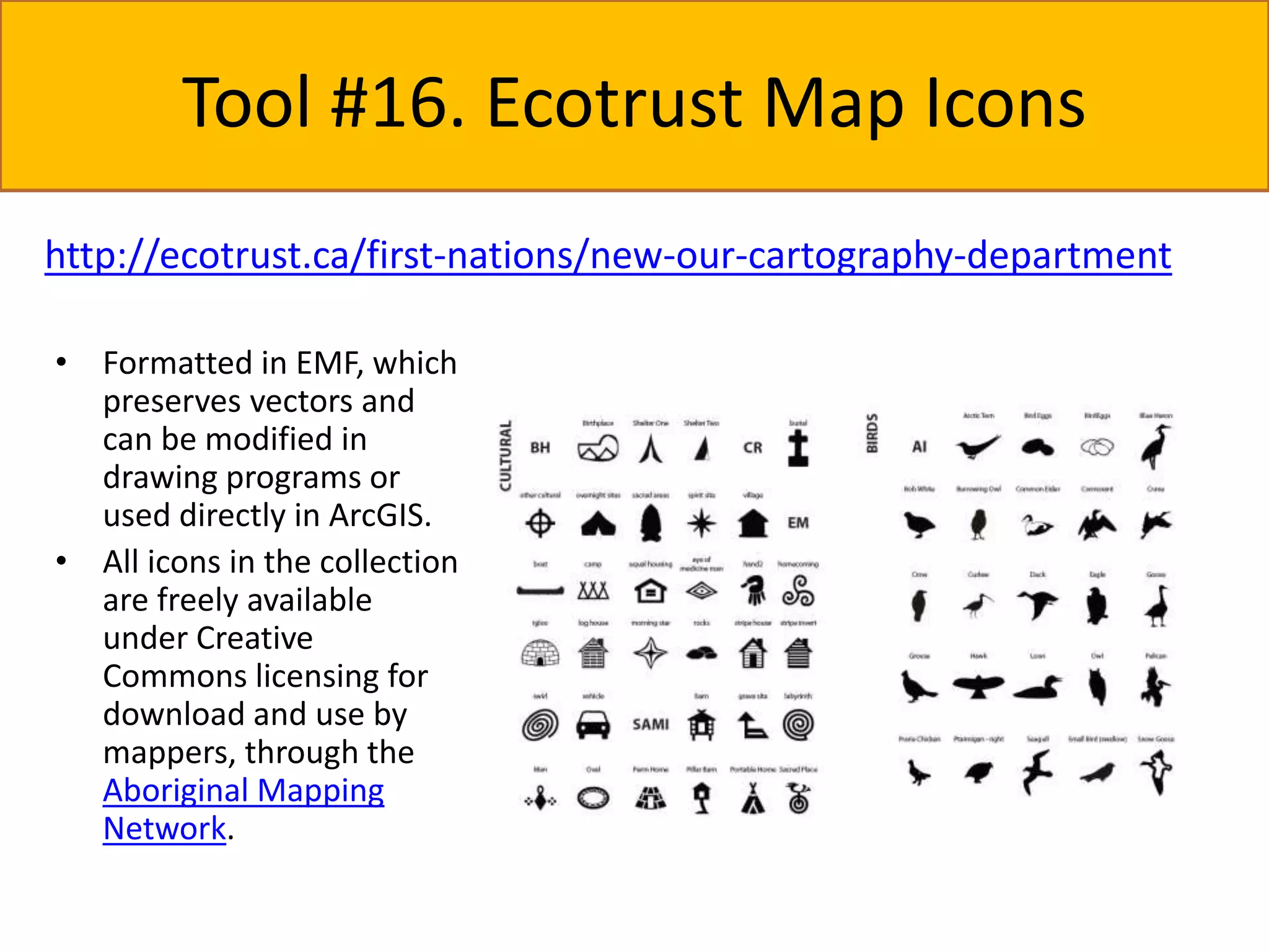
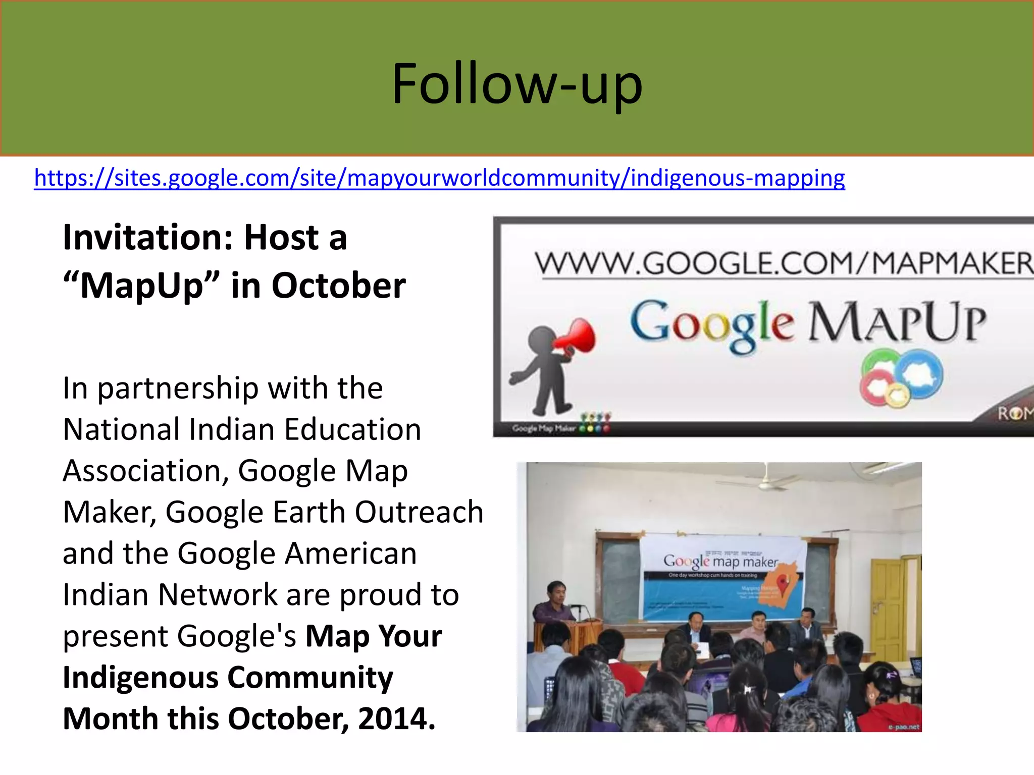
SlideShare a Scribd company logo
1 of 53
IMW2014 Tools Scan 
A brief answer to the question: 
“What ‘free-ish’ mapping tools were 
explored at IMW2014?”
http://imwcanada.earthoutreach.org/ 
Held in Victoria BC on 
25-28 August 2014 
Representing more than 
40 First Nations, Metis and 
Inuit communities, 
community-based mapping 
practitioners, and university-based 
researchers from 
across Canada
Acknowledgments 
IMW2014 was organized and hosted by: 
Union of British Columbia Indian Chiefs – Don & Angie Bain 
University of Victoria, Anthropology – Prof. Brian Thom & Team 
The Firelight Group – Steve Deroy, Rachel Olson & Team 
Google Earth Outreach – Raleigh Seamster & Crew
Here is the list of Tools we’ll peek at: 
1. Google Earth – 3D placemaking, with advanced examples Amazon and Australia 
2. Google Earth for Use & Occupancy Mapping – With an introduction to Firelight Group's 
Direct-to-Digital UOM/TUS methodology 
3. Google Earth, Tour Builder – Make a tour of your Territory 
4. Google Earth Engine – Environmental Impact analysis tools? 
5. Google Earth Engine – Forest change 
6. Google Earth Engine with Fusion Tables – Share and visualize tabular data 
7. Google Earth and GPS/Photos – Getting your monitoring data uploaded 
8. Google Maps, MapMaker – Request additions/changes to maps in your Territory 
9. Google Maps, Street View – Adding your own data & spheric photographs 
10. Google Maps, Views – Street View highlights, without the street! 
11. Maps Engine Lite plus Google Forms and Sheets – A cultural map toolkit 
12. Google Maps Coordinate - Workforce management tool for mobile teams 
13. Open Data Kit – Mobile multimedia field monitoring forms 
14. GeoLive.ca – Placemaking and placenames tool with multimedia 
15. Quantum GIS + LibreOffice Base – Desktop GIS for the whole office! 
16. Ecotrust map icons – Amazing (desktop GIS format) icons for cultural mapping
Tool #1. Google Earth 
• Google Earth is a virtual globe, map and 
geographical information program. It maps the 
Earth by the superimposition of images obtained 
from satellite imagery, aerial photography and 
geographic information system (GIS) 3D globe. 
• As of October 2011, Google Earth has been 
downloaded more than a billion times. 
• For some parts of the surface of the Earth, 3D 
images of terrain and buildings are available 
• Available free or US$399/year for Pro 
http://www.google.com/earth/
Easy to add points, lines and polygons 
At IMW2014, we also 
discussed uploading a 
Shapefile or KML file.
Limited but effective pop-ups & styling
How are screen overlays different from image overlays? 
Screen overlay (e.g. logos) Image overlay (e.g. thematic map 
layer) 
#1 Screen overlays are anchored relative to the screen. 
Image (ground) overlays are anchored relative to the ground. 
#2 Image (ground) overlays can be added with the toolbar button. 
Screen overlays are added in the KML code. 
#3 In the above examples, the legend and logos are screen 
overlays and the wetland map is a image (ground) overlay.
Google Earth Example #1 
• Surui Cultural Map 
• 5yr collaboration 
• “Trading Bows and 
Arrows for Laptops: 
Carbon and Culture.” 
• Surui created points of 
interest (POIs) that reflect 
their traditional culture’s 
close interdependency 
with their forest home. 
http://googleblog.blogspot.ca/2012/06/surui-cultural-map.html
Google Earth Example #2 
• Ngarluma Ngurra 
Cultural Map 
• “When Aboriginal 
people walk on the 
land, the land is 
happy” – Geoffrey Togo, 
Ngarluma Elder 
• FORM is a recipient of 
the Google Earth 
Outreach grants 
program 
http://www.form.net.au/project/ngarluma-ngurra/
Google Earth Example #3 
• Embed Google Earth in a webpage as a YouTube 
link or using the Earth Embed Gadget 
http://cherokee.wildsouth.org/video 
http://www.google.ca/earth/outreach/tutorials/kmlembed.html
Tool #2. Google Earth for UOM 
Doing Use & Occupancy Mapping (UOM) 
(Traditional Use Studies) with Earth using 
the Direct-to-digital methodology… 
Courtesy of The Firelight Group 
Courtesy of The Firelight Group
Direct-to-digital 
D2D uses Data Diamonds 
introduced by - Terry Tobias in 
Living Proof… 
Activity 
(what) 
Time period Person 
(when) (who) 
Location 
(where) 
Living Proof is available for $50 at 
http://www.ubcic.bc.ca/livingproof/index.html 
…but tries to dramatically reduce the 
time required to process interview data 
while also helping interviewees find 
locations using Earth’s 3D maps.
Direct-to-digital Folder Examples 
Being very organized is the key to success…
Google Earth UOM Example #1 
Snuneymuxw Land Use and Occupancy
Google Earth UOM Example #2 
Lekwungen Territory Ethnographic Mapping project
Tool #3. Google Earth Tour Builder 
https://tourbuilder.withgoogle.com/ 
Tour Builder is a 
new way to show 
people the places 
you've visited and 
the experiences you 
had along the way 
using Google Earth. 
It lets you pick the 
locations right on 
the map, add in 
photos, text, and 
video, and then 
share your 
creation.
Tool #4. Earth Engine – EIA 
Tools for assisting with Environmental Impact Assessments… 
• Storytelling 
through time 
series 
• Useful pre-computed 
products (see 
next slide) 
• You can also 
upload your 
own data 
vector or 
raster data 
http://www.cisl.ucar.edu/hss/workshops/ManoMarks.pdf
Timelapse analysis example 
https://earthengine.google.org/timelapse
Summary ● Easily accessible satellite imagery 
and vectors (or your own data) 
● Methods for performing analyses 
with those data 
● Parallelized and run in the Google 
cloud 
● Download results or export to Maps 
Engine 
Imagery Classification Demo 
http://earthengine.google.org 
EE API Demo 
http://ee-api.appspot.com
Make your own Timelapse tours...
Tool #5. Earth Engine – Forest Change 
https://earthengine.google.org/timelapse 
• Access 40 years of 
cloud-free satellite 
imagery 
• Make your own 
time lapse movies: 
http://bit.ly/toured 
itor
Global forest change data produced using Earth Engine 
http://earthenginepartners.appspot.com/science-2013-global-forest
GPS on your mobile device Tool #6. Earth Engine with Fusion Tables 
• Upload large 
(100MB) 
tabular data 
• Easy 
visualization 
• Easy mapping 
• Customize info 
windows 
• Customize 
shapes 
• Spatial 
Queries! 
• FusionTableLay 
er in Maps API 
• Fusion Tables 
API
http://www.whrc.org/education/tanzania/Presentations/ee_advanced_jgi_2012_day4.pdf
GPS on your mobile device 
Tool #7. Google Earth and GPS/Photos 
Android Phones & Tablets iOS: iPhone, iPad 
Collect tracks on your phone or tablet using the tools listed above.
Watch a video tutorial about GPS 
uploads at 
https://www.youtube.com/watch?v=3NkgeoClHrQ
You can get geocoded photos (EXIF metadata stores lat/long) into Google Earth by using 
Google’s Picasa application. Select the photos you want to view in Earth and click Tools > 
Geotag > Export to Google Earth File.
Tool #8. Google Maps – MapMaker 
Join the army of people making changes to Google Maps. Add points, routes, places and 
building outlines for your community. Sign for free. All chnages are moderated, but 
changes are published quickly! 
http://www.google.ca/mapmaker/
Join the MapMaker community… 
https://sites.google.com/site/mapmakerpedia/
Tool #9. Google Maps - Street View 
https://www.google.com/maps/views/streetview 
Google Trike in Cambridge Bay, Nunavut, 
August 23, 2012 
Google Streetview of Kitsumkalum, 
Terrace, BC
http://www.google.com/maps/about/behi 
nd-the-scenes/streetview/ 
Street View coverage (as of August 2014)
DIY - Add imagery to Street View 
Collect your own 360° panoramas using an iPhone, Android 
device (Photo Sphere app), or Ricoh Theta…. and submit 
them to Street View.
Note that Google Earth Outreach has Trekker & 
Tripod Loans available…
Tool #10. Google Maps - Views 
https://www.google.com/maps/views/ 
• Storytelling 
through 
Streetview 
imagery
You link to (but not embed, yet) Views on your website 
http://fas-amazonas.org 
https://www.google.ca/earth/outreach/stories/fas.html
Tool #11. Maps Engine Lite plus Google 
Forms and Sheets 
Dr. Brian Thom: “We can 
crowd-source Google Maps 
Engine Lite by using tools in 
Drive like Forms and Sheets…”
… then import the Sheet into Maps 
Engine Lite
… and on the import 
Google Maps Engine will 
geocode your data… 
… and ask you which 
column to use to label 
your placemarks…
Share a link to your map… 
Set your privacy 
settings…
And then…. view in Android with 
Google Maps Engine for Android App!
Tool #12. Google Maps Coordinate 
http://maps.google.com/coordinate 
Real-Time Visibility 
Maps Engine Pro now 
includes Maps Coordinate, 
our easy-to-use tool for 
managing mobile teams. 
Get more done by giving 
the right jobs to the right 
people at the right time. 
• Google Maps Coordinate runs on GPS-equipped 
Android and Apple smart 
phones 
• The price for Maps Engine Pro is $5 per 
user and month.
Tool #13. Open Data Kit 
• Open Data Kit (ODK) is a free and open-source set 
of tools which help organizations author, field, 
and manage mobile data collection solutions. 
Parts: 
– Build a data collection form or survey (XLSForm is 
recommended for larger forms); 
– Collect the data on a mobile 
device and send it to a server; and 
– Aggregate the collected data 
on a server and extract it in 
useful formats.
Create forms 
ODK Collect 
Analyze Data 
Submit Data to 
Maps Engine 
Validate 
Collect Data 
Google Maps Engine & 
Google Earth Engine 
ODK Build (simple) XLS 
Forms (complex) 
Publish Maps 
CNreeaar tree faoltrimmse wdiathta O cDolKle cBtuioilnd
Create forms with ODK Build
Effort (yellow) and 
threats (red) collected 
by village forest 
monitors using ODK 
around Gombe National 
Park, Tanzania
Tool #14. GeoLive.ca 
http://geolive.ca 
GeoLive is a flexible 
and extendable 
online participatory 
mapping tool, 
designed to facilitate 
communities’ ability 
to capture, manage 
and communicate 
their stories. 
Check out the Taku 
River Tlingit live map: 
http://trt.geolive.ca/
Tool #15. Quantum GIS + LibreOffice 
http://www.qgis.org 
http://libreoffice.org 
From IMW2014 talk 
Saulteau Goes Open Source 
by Donovan Cameron. 
• “We track referrals in a flat file 
database (LibreOffice, free), using 
forms to populate. Every member of 
our team has Quantum GIS (free) 
installed on their workstation, and 
they can explore spatial impacts.”
Tool #16. Ecotrust Map Icons 
http://ecotrust.ca/first-nations/new-our-cartography-department 
• Formatted in EMF, which 
preserves vectors and 
can be modified in 
drawing programs or 
used directly in ArcGIS. 
• All icons in the collection 
are freely available 
under Creative 
Commons licensing for 
download and use by 
mappers, through the 
Aboriginal Mapping 
Network.
Follow-up 
https://sites.google.com/site/mapyourworldcommunity/indigenous-mapping 
Invitation: Host a 
“MapUp” in October 
In partnership with the 
National Indian Education 
Association, Google Map 
Maker, Google Earth Outreach 
and the Google American 
Indian Network are proud to 
present Google's Map Your 
Indigenous Community 
Month this October, 2014.
Note: 
This scan is not comprehensive. There were many tools demonstrated during the first two days of 
IMW@2014 that I do not have images for. And, I could not be at every workshop session. 
If I have omitted a tool that should be in this list, please email me at charles@geomemes.com. 
I would be very happy to include more free-ish tools! 
IMW2014 Tools Scan Slidedeck 
assembled by Charles Burnett 
GeoMemes Research | UVic Geography 
charles@geomemes.com 
IMW2014 slidedeck slides were re-used with permission. 
You can find the original workshop slide decks at 
http://imwcanada.earthoutreach.org/training-materials

More Related Content

What's hot

Switch board for himalayan disaster management ver 6
Switch board for himalayan disaster management ver 6Switch board for himalayan disaster management ver 6
Switch board for himalayan disaster management ver 6anjchal
 
Solar system Mini Means Presentation - UDL Playground ICE Conference
Solar system Mini Means Presentation - UDL Playground ICE ConferenceSolar system Mini Means Presentation - UDL Playground ICE Conference
Solar system Mini Means Presentation - UDL Playground ICE Conferencepblack00
 
Geo-ing Global TeachMeet BETT 2011
Geo-ing Global TeachMeet BETT 2011Geo-ing Global TeachMeet BETT 2011
Geo-ing Global TeachMeet BETT 2011Dom Breadmore
 
OSGeo.nl - Introductie - Geo Freedom Day
OSGeo.nl - Introductie - Geo Freedom DayOSGeo.nl - Introductie - Geo Freedom Day
OSGeo.nl - Introductie - Geo Freedom DayJust van den Broecke
 
Feature Detection in Aerial Images for Post-Disaster Needs Assessment (report)
Feature Detection in Aerial Images for Post-Disaster Needs Assessment (report)Feature Detection in Aerial Images for Post-Disaster Needs Assessment (report)
Feature Detection in Aerial Images for Post-Disaster Needs Assessment (report)Thomas Templin
 
IN140703 service support technologies 4.10.2016
IN140703 service support technologies 4.10.2016IN140703 service support technologies 4.10.2016
IN140703 service support technologies 4.10.2016Pirita Ihamäki
 
Google mapping in the newsroom part 1
Google mapping in the newsroom part 1Google mapping in the newsroom part 1
Google mapping in the newsroom part 1Esther Vargas
 
Build an OSM mapping platform with Drupal
Build an OSM mapping platform with DrupalBuild an OSM mapping platform with Drupal
Build an OSM mapping platform with DrupalHoshi Liu
 
Eurosha kenya pres_osm_en_20121031
Eurosha kenya pres_osm_en_20121031Eurosha kenya pres_osm_en_20121031
Eurosha kenya pres_osm_en_20121031Severin Menard
 
The Future of the Map
The Future of the MapThe Future of the Map
The Future of the Mapelliotharmon
 

What's hot (12)

Switch board for himalayan disaster management ver 6
Switch board for himalayan disaster management ver 6Switch board for himalayan disaster management ver 6
Switch board for himalayan disaster management ver 6
 
Solar system Mini Means Presentation - UDL Playground ICE Conference
Solar system Mini Means Presentation - UDL Playground ICE ConferenceSolar system Mini Means Presentation - UDL Playground ICE Conference
Solar system Mini Means Presentation - UDL Playground ICE Conference
 
Geo-ing Global TeachMeet BETT 2011
Geo-ing Global TeachMeet BETT 2011Geo-ing Global TeachMeet BETT 2011
Geo-ing Global TeachMeet BETT 2011
 
OSGeo.nl - Introductie - Geo Freedom Day
OSGeo.nl - Introductie - Geo Freedom DayOSGeo.nl - Introductie - Geo Freedom Day
OSGeo.nl - Introductie - Geo Freedom Day
 
Feature Detection in Aerial Images for Post-Disaster Needs Assessment (report)
Feature Detection in Aerial Images for Post-Disaster Needs Assessment (report)Feature Detection in Aerial Images for Post-Disaster Needs Assessment (report)
Feature Detection in Aerial Images for Post-Disaster Needs Assessment (report)
 
IN140703 service support technologies 4.10.2016
IN140703 service support technologies 4.10.2016IN140703 service support technologies 4.10.2016
IN140703 service support technologies 4.10.2016
 
Google mapping in the newsroom part 1
Google mapping in the newsroom part 1Google mapping in the newsroom part 1
Google mapping in the newsroom part 1
 
Build an OSM mapping platform with Drupal
Build an OSM mapping platform with DrupalBuild an OSM mapping platform with Drupal
Build an OSM mapping platform with Drupal
 
Geospatial Tech in Teaching
Geospatial Tech in TeachingGeospatial Tech in Teaching
Geospatial Tech in Teaching
 
Eurosha kenya pres_osm_en_20121031
Eurosha kenya pres_osm_en_20121031Eurosha kenya pres_osm_en_20121031
Eurosha kenya pres_osm_en_20121031
 
The Future of the Map
The Future of the MapThe Future of the Map
The Future of the Map
 
Google services overview
Google services overviewGoogle services overview
Google services overview
 

Similar to IMW2014 Tools Scan - Top Free Mapping Tools Explored

Visualizing Your Cause In Google Earth Maps @ NTC 2010
Visualizing Your Cause In Google Earth Maps @ NTC 2010Visualizing Your Cause In Google Earth Maps @ NTC 2010
Visualizing Your Cause In Google Earth Maps @ NTC 2010googlenten
 
Google Map and Google earth .ppt
Google Map and Google earth .pptGoogle Map and Google earth .ppt
Google Map and Google earth .pptNajeebullahSadiq1
 
Modified Resource Google Presentation
Modified Resource Google PresentationModified Resource Google Presentation
Modified Resource Google PresentationWilliam Worford
 
Free GIS Resources
Free GIS ResourcesFree GIS Resources
Free GIS Resourcesrutlandrpc
 
Maps and Apps
Maps and AppsMaps and Apps
Maps and AppsAddy Pope
 
Tech toolbox tidbits
Tech toolbox tidbitsTech toolbox tidbits
Tech toolbox tidbitsJD Williamson
 
#NISMIL Geo Tools for Journalists (by Elisabetta Tola)
#NISMIL Geo Tools for Journalists (by Elisabetta Tola)#NISMIL Geo Tools for Journalists (by Elisabetta Tola)
#NISMIL Geo Tools for Journalists (by Elisabetta Tola)Mattia Peretti
 
Google report 01
Google report 01Google report 01
Google report 01Sunny Gupta
 
Google Earth Web2.0.Key
Google Earth Web2.0.KeyGoogle Earth Web2.0.Key
Google Earth Web2.0.Keylindleyh
 
Of Nodes and Maps (Web Mapping with Drupal - Part II)
Of Nodes and Maps (Web Mapping with Drupal - Part II)Of Nodes and Maps (Web Mapping with Drupal - Part II)
Of Nodes and Maps (Web Mapping with Drupal - Part II)Ranel Padon
 
Introduction to OpenStreetMap and Humanitarian OSM Team for Plan Internationa...
Introduction to OpenStreetMap and Humanitarian OSM Team for Plan Internationa...Introduction to OpenStreetMap and Humanitarian OSM Team for Plan Internationa...
Introduction to OpenStreetMap and Humanitarian OSM Team for Plan Internationa...chippy
 
Digital maps: past, present; on your desktop and in the palm of your hand
Digital maps: past, present; on your desktop and in the palm of your handDigital maps: past, present; on your desktop and in the palm of your hand
Digital maps: past, present; on your desktop and in the palm of your handEDINA, University of Edinburgh
 
Google Tools For Education
Google Tools For EducationGoogle Tools For Education
Google Tools For EducationDionne Curbeam
 
Learning Expeditions
Learning ExpeditionsLearning Expeditions
Learning Expeditionstcooper66
 
Google map tutorials
Google map tutorialsGoogle map tutorials
Google map tutorialsZreena
 
Google Earth Tutorials - Part I
Google Earth Tutorials - Part IGoogle Earth Tutorials - Part I
Google Earth Tutorials - Part Itcooper66
 

Similar to IMW2014 Tools Scan - Top Free Mapping Tools Explored (20)

Visualizing Your Cause In Google Earth Maps @ NTC 2010
Visualizing Your Cause In Google Earth Maps @ NTC 2010Visualizing Your Cause In Google Earth Maps @ NTC 2010
Visualizing Your Cause In Google Earth Maps @ NTC 2010
 
Google Earth.ppt
Google Earth.pptGoogle Earth.ppt
Google Earth.ppt
 
Google Map and Google earth .ppt
Google Map and Google earth .pptGoogle Map and Google earth .ppt
Google Map and Google earth .ppt
 
Modified Resource Google Presentation
Modified Resource Google PresentationModified Resource Google Presentation
Modified Resource Google Presentation
 
Participatory Web
Participatory WebParticipatory Web
Participatory Web
 
Free GIS Resources
Free GIS ResourcesFree GIS Resources
Free GIS Resources
 
Maps and Apps
Maps and AppsMaps and Apps
Maps and Apps
 
Google Tools 2015
Google Tools 2015Google Tools 2015
Google Tools 2015
 
Tech toolbox tidbits
Tech toolbox tidbitsTech toolbox tidbits
Tech toolbox tidbits
 
#NISMIL Geo Tools for Journalists (by Elisabetta Tola)
#NISMIL Geo Tools for Journalists (by Elisabetta Tola)#NISMIL Geo Tools for Journalists (by Elisabetta Tola)
#NISMIL Geo Tools for Journalists (by Elisabetta Tola)
 
Google report 01
Google report 01Google report 01
Google report 01
 
Google Earth Web2.0.Key
Google Earth Web2.0.KeyGoogle Earth Web2.0.Key
Google Earth Web2.0.Key
 
Of Nodes and Maps (Web Mapping with Drupal - Part II)
Of Nodes and Maps (Web Mapping with Drupal - Part II)Of Nodes and Maps (Web Mapping with Drupal - Part II)
Of Nodes and Maps (Web Mapping with Drupal - Part II)
 
Introduction to OpenStreetMap and Humanitarian OSM Team for Plan Internationa...
Introduction to OpenStreetMap and Humanitarian OSM Team for Plan Internationa...Introduction to OpenStreetMap and Humanitarian OSM Team for Plan Internationa...
Introduction to OpenStreetMap and Humanitarian OSM Team for Plan Internationa...
 
Digital maps: past, present; on your desktop and in the palm of your hand
Digital maps: past, present; on your desktop and in the palm of your handDigital maps: past, present; on your desktop and in the palm of your hand
Digital maps: past, present; on your desktop and in the palm of your hand
 
Google Tools For Education
Google Tools For EducationGoogle Tools For Education
Google Tools For Education
 
Learning Expeditions
Learning ExpeditionsLearning Expeditions
Learning Expeditions
 
Google map tutorials
Google map tutorialsGoogle map tutorials
Google map tutorials
 
Google Next
Google NextGoogle Next
Google Next
 
Google Earth Tutorials - Part I
Google Earth Tutorials - Part IGoogle Earth Tutorials - Part I
Google Earth Tutorials - Part I
 

More from Charles Burnett

Burnett Presentation at UVic Community Mapping Showcase
Burnett Presentation at UVic Community Mapping ShowcaseBurnett Presentation at UVic Community Mapping Showcase
Burnett Presentation at UVic Community Mapping ShowcaseCharles Burnett
 
Web-GIS-based Conservation Tools for First Nations' Stewardship
Web-GIS-based Conservation Tools for First Nations' StewardshipWeb-GIS-based Conservation Tools for First Nations' Stewardship
Web-GIS-based Conservation Tools for First Nations' StewardshipCharles Burnett
 
CIS - GeoMemes Research - June 2012 Update
CIS  - GeoMemes Research - June 2012 UpdateCIS  - GeoMemes Research - June 2012 Update
CIS - GeoMemes Research - June 2012 UpdateCharles Burnett
 
A Web-Based, Federated, Marine Use Management System for Small Communities
A Web-Based, Federated, Marine Use Management System for Small CommunitiesA Web-Based, Federated, Marine Use Management System for Small Communities
A Web-Based, Federated, Marine Use Management System for Small CommunitiesCharles Burnett
 
Building Community Information Systems with Drupal and Open Layers Rev2
Building Community Information Systems with Drupal and Open Layers Rev2Building Community Information Systems with Drupal and Open Layers Rev2
Building Community Information Systems with Drupal and Open Layers Rev2Charles Burnett
 
Building Community Information Systems with Drupal and Open Layers
Building Community Information Systems with Drupal and Open LayersBuilding Community Information Systems with Drupal and Open Layers
Building Community Information Systems with Drupal and Open LayersCharles Burnett
 

More from Charles Burnett (6)

Burnett Presentation at UVic Community Mapping Showcase
Burnett Presentation at UVic Community Mapping ShowcaseBurnett Presentation at UVic Community Mapping Showcase
Burnett Presentation at UVic Community Mapping Showcase
 
Web-GIS-based Conservation Tools for First Nations' Stewardship
Web-GIS-based Conservation Tools for First Nations' StewardshipWeb-GIS-based Conservation Tools for First Nations' Stewardship
Web-GIS-based Conservation Tools for First Nations' Stewardship
 
CIS - GeoMemes Research - June 2012 Update
CIS  - GeoMemes Research - June 2012 UpdateCIS  - GeoMemes Research - June 2012 Update
CIS - GeoMemes Research - June 2012 Update
 
A Web-Based, Federated, Marine Use Management System for Small Communities
A Web-Based, Federated, Marine Use Management System for Small CommunitiesA Web-Based, Federated, Marine Use Management System for Small Communities
A Web-Based, Federated, Marine Use Management System for Small Communities
 
Building Community Information Systems with Drupal and Open Layers Rev2
Building Community Information Systems with Drupal and Open Layers Rev2Building Community Information Systems with Drupal and Open Layers Rev2
Building Community Information Systems with Drupal and Open Layers Rev2
 
Building Community Information Systems with Drupal and Open Layers
Building Community Information Systems with Drupal and Open LayersBuilding Community Information Systems with Drupal and Open Layers
Building Community Information Systems with Drupal and Open Layers
 

Recently uploaded

“Exploring the world: One page turn at a time.” World Book and Copyright Day ...
“Exploring the world: One page turn at a time.” World Book and Copyright Day ...“Exploring the world: One page turn at a time.” World Book and Copyright Day ...
“Exploring the world: One page turn at a time.” World Book and Copyright Day ...Christina Parmionova
 
No.1 Call Girls in Basavanagudi ! 7001305949 ₹2999 Only and Free Hotel Delive...
No.1 Call Girls in Basavanagudi ! 7001305949 ₹2999 Only and Free Hotel Delive...No.1 Call Girls in Basavanagudi ! 7001305949 ₹2999 Only and Free Hotel Delive...
No.1 Call Girls in Basavanagudi ! 7001305949 ₹2999 Only and Free Hotel Delive...narwatsonia7
 
Russian Call Girl Hebbagodi ! 7001305949 ₹2999 Only and Free Hotel Delivery 2...
Russian Call Girl Hebbagodi ! 7001305949 ₹2999 Only and Free Hotel Delivery 2...Russian Call Girl Hebbagodi ! 7001305949 ₹2999 Only and Free Hotel Delivery 2...
Russian Call Girl Hebbagodi ! 7001305949 ₹2999 Only and Free Hotel Delivery 2...narwatsonia7
 
call girls in Tilak Nagar DELHI 🔝 >༒9540349809 🔝 genuine Escort Service 🔝✔️✔️
call girls in Tilak Nagar DELHI 🔝 >༒9540349809 🔝 genuine Escort Service 🔝✔️✔️call girls in Tilak Nagar DELHI 🔝 >༒9540349809 🔝 genuine Escort Service 🔝✔️✔️
call girls in Tilak Nagar DELHI 🔝 >༒9540349809 🔝 genuine Escort Service 🔝✔️✔️saminamagar
 
Take action for a healthier planet and brighter future.
Take action for a healthier planet and brighter future.Take action for a healthier planet and brighter future.
Take action for a healthier planet and brighter future.Christina Parmionova
 
Call Girls In Le Meridien hotel New Delhi 9873777170
Call Girls In Le Meridien hotel New Delhi 9873777170Call Girls In Le Meridien hotel New Delhi 9873777170
Call Girls In Le Meridien hotel New Delhi 9873777170avaniranaescorts
 
history of 1935 philippine constitution.pptx
history of 1935 philippine constitution.pptxhistory of 1935 philippine constitution.pptx
history of 1935 philippine constitution.pptxhellokittymaearciaga
 
call girls in Punjabi Bagh DELHI 🔝 >༒9540349809 🔝 genuine Escort Service 🔝✔️✔️
call girls in Punjabi Bagh DELHI 🔝 >༒9540349809 🔝 genuine Escort Service 🔝✔️✔️call girls in Punjabi Bagh DELHI 🔝 >༒9540349809 🔝 genuine Escort Service 🔝✔️✔️
call girls in Punjabi Bagh DELHI 🔝 >༒9540349809 🔝 genuine Escort Service 🔝✔️✔️saminamagar
 
Club of Rome: Eco-nomics for an Ecological Civilization
Club of Rome: Eco-nomics for an Ecological CivilizationClub of Rome: Eco-nomics for an Ecological Civilization
Club of Rome: Eco-nomics for an Ecological CivilizationEnergy for One World
 
Powering Britain: Can we decarbonise electricity without disadvantaging poore...
Powering Britain: Can we decarbonise electricity without disadvantaging poore...Powering Britain: Can we decarbonise electricity without disadvantaging poore...
Powering Britain: Can we decarbonise electricity without disadvantaging poore...ResolutionFoundation
 
Enhancing Indigenous Peoples' right to self-determination in the context of t...
Enhancing Indigenous Peoples' right to self-determination in the context of t...Enhancing Indigenous Peoples' right to self-determination in the context of t...
Enhancing Indigenous Peoples' right to self-determination in the context of t...Christina Parmionova
 
Earth Day 2024 - AMC "COMMON GROUND'' movie night.
Earth Day 2024 - AMC "COMMON GROUND'' movie night.Earth Day 2024 - AMC "COMMON GROUND'' movie night.
Earth Day 2024 - AMC "COMMON GROUND'' movie night.Christina Parmionova
 
call girls in West Patel Nagar DELHI 🔝 >༒9540349809 🔝 genuine Escort Service ...
call girls in West Patel Nagar DELHI 🔝 >༒9540349809 🔝 genuine Escort Service ...call girls in West Patel Nagar DELHI 🔝 >༒9540349809 🔝 genuine Escort Service ...
call girls in West Patel Nagar DELHI 🔝 >༒9540349809 🔝 genuine Escort Service ...saminamagar
 
Call Girls Connaught Place Delhi reach out to us at ☎ 9711199012
Call Girls Connaught Place Delhi reach out to us at ☎ 9711199012Call Girls Connaught Place Delhi reach out to us at ☎ 9711199012
Call Girls Connaught Place Delhi reach out to us at ☎ 9711199012rehmti665
 
Goa Escorts WhatsApp Number South Goa Call Girl … 8588052666…
Goa Escorts WhatsApp Number South Goa Call Girl … 8588052666…Goa Escorts WhatsApp Number South Goa Call Girl … 8588052666…
Goa Escorts WhatsApp Number South Goa Call Girl … 8588052666…nishakur201
 
How the Congressional Budget Office Assists Lawmakers
How the Congressional Budget Office Assists LawmakersHow the Congressional Budget Office Assists Lawmakers
How the Congressional Budget Office Assists LawmakersCongressional Budget Office
 
2024: The FAR, Federal Acquisition Regulations - Part 27
2024: The FAR, Federal Acquisition Regulations - Part 272024: The FAR, Federal Acquisition Regulations - Part 27
2024: The FAR, Federal Acquisition Regulations - Part 27JSchaus & Associates
 
Start Donating your Old Clothes to Poor People
Start Donating your Old Clothes to Poor PeopleStart Donating your Old Clothes to Poor People
Start Donating your Old Clothes to Poor PeopleSERUDS INDIA
 

Recently uploaded (20)

“Exploring the world: One page turn at a time.” World Book and Copyright Day ...
“Exploring the world: One page turn at a time.” World Book and Copyright Day ...“Exploring the world: One page turn at a time.” World Book and Copyright Day ...
“Exploring the world: One page turn at a time.” World Book and Copyright Day ...
 
No.1 Call Girls in Basavanagudi ! 7001305949 ₹2999 Only and Free Hotel Delive...
No.1 Call Girls in Basavanagudi ! 7001305949 ₹2999 Only and Free Hotel Delive...No.1 Call Girls in Basavanagudi ! 7001305949 ₹2999 Only and Free Hotel Delive...
No.1 Call Girls in Basavanagudi ! 7001305949 ₹2999 Only and Free Hotel Delive...
 
Russian Call Girl Hebbagodi ! 7001305949 ₹2999 Only and Free Hotel Delivery 2...
Russian Call Girl Hebbagodi ! 7001305949 ₹2999 Only and Free Hotel Delivery 2...Russian Call Girl Hebbagodi ! 7001305949 ₹2999 Only and Free Hotel Delivery 2...
Russian Call Girl Hebbagodi ! 7001305949 ₹2999 Only and Free Hotel Delivery 2...
 
call girls in Tilak Nagar DELHI 🔝 >༒9540349809 🔝 genuine Escort Service 🔝✔️✔️
call girls in Tilak Nagar DELHI 🔝 >༒9540349809 🔝 genuine Escort Service 🔝✔️✔️call girls in Tilak Nagar DELHI 🔝 >༒9540349809 🔝 genuine Escort Service 🔝✔️✔️
call girls in Tilak Nagar DELHI 🔝 >༒9540349809 🔝 genuine Escort Service 🔝✔️✔️
 
Take action for a healthier planet and brighter future.
Take action for a healthier planet and brighter future.Take action for a healthier planet and brighter future.
Take action for a healthier planet and brighter future.
 
Call Girls In Le Meridien hotel New Delhi 9873777170
Call Girls In Le Meridien hotel New Delhi 9873777170Call Girls In Le Meridien hotel New Delhi 9873777170
Call Girls In Le Meridien hotel New Delhi 9873777170
 
history of 1935 philippine constitution.pptx
history of 1935 philippine constitution.pptxhistory of 1935 philippine constitution.pptx
history of 1935 philippine constitution.pptx
 
call girls in Punjabi Bagh DELHI 🔝 >༒9540349809 🔝 genuine Escort Service 🔝✔️✔️
call girls in Punjabi Bagh DELHI 🔝 >༒9540349809 🔝 genuine Escort Service 🔝✔️✔️call girls in Punjabi Bagh DELHI 🔝 >༒9540349809 🔝 genuine Escort Service 🔝✔️✔️
call girls in Punjabi Bagh DELHI 🔝 >༒9540349809 🔝 genuine Escort Service 🔝✔️✔️
 
Club of Rome: Eco-nomics for an Ecological Civilization
Club of Rome: Eco-nomics for an Ecological CivilizationClub of Rome: Eco-nomics for an Ecological Civilization
Club of Rome: Eco-nomics for an Ecological Civilization
 
Powering Britain: Can we decarbonise electricity without disadvantaging poore...
Powering Britain: Can we decarbonise electricity without disadvantaging poore...Powering Britain: Can we decarbonise electricity without disadvantaging poore...
Powering Britain: Can we decarbonise electricity without disadvantaging poore...
 
Enhancing Indigenous Peoples' right to self-determination in the context of t...
Enhancing Indigenous Peoples' right to self-determination in the context of t...Enhancing Indigenous Peoples' right to self-determination in the context of t...
Enhancing Indigenous Peoples' right to self-determination in the context of t...
 
Earth Day 2024 - AMC "COMMON GROUND'' movie night.
Earth Day 2024 - AMC "COMMON GROUND'' movie night.Earth Day 2024 - AMC "COMMON GROUND'' movie night.
Earth Day 2024 - AMC "COMMON GROUND'' movie night.
 
call girls in West Patel Nagar DELHI 🔝 >༒9540349809 🔝 genuine Escort Service ...
call girls in West Patel Nagar DELHI 🔝 >༒9540349809 🔝 genuine Escort Service ...call girls in West Patel Nagar DELHI 🔝 >༒9540349809 🔝 genuine Escort Service ...
call girls in West Patel Nagar DELHI 🔝 >༒9540349809 🔝 genuine Escort Service ...
 
Call Girls Connaught Place Delhi reach out to us at ☎ 9711199012
Call Girls Connaught Place Delhi reach out to us at ☎ 9711199012Call Girls Connaught Place Delhi reach out to us at ☎ 9711199012
Call Girls Connaught Place Delhi reach out to us at ☎ 9711199012
 
Goa Escorts WhatsApp Number South Goa Call Girl … 8588052666…
Goa Escorts WhatsApp Number South Goa Call Girl … 8588052666…Goa Escorts WhatsApp Number South Goa Call Girl … 8588052666…
Goa Escorts WhatsApp Number South Goa Call Girl … 8588052666…
 
How the Congressional Budget Office Assists Lawmakers
How the Congressional Budget Office Assists LawmakersHow the Congressional Budget Office Assists Lawmakers
How the Congressional Budget Office Assists Lawmakers
 
The Federal Budget and Health Care Policy
The Federal Budget and Health Care PolicyThe Federal Budget and Health Care Policy
The Federal Budget and Health Care Policy
 
2024: The FAR, Federal Acquisition Regulations - Part 27
2024: The FAR, Federal Acquisition Regulations - Part 272024: The FAR, Federal Acquisition Regulations - Part 27
2024: The FAR, Federal Acquisition Regulations - Part 27
 
Start Donating your Old Clothes to Poor People
Start Donating your Old Clothes to Poor PeopleStart Donating your Old Clothes to Poor People
Start Donating your Old Clothes to Poor People
 
Model Town (Delhi) 9953330565 Escorts, Call Girls Services
Model Town (Delhi)  9953330565 Escorts, Call Girls ServicesModel Town (Delhi)  9953330565 Escorts, Call Girls Services
Model Town (Delhi) 9953330565 Escorts, Call Girls Services
 

IMW2014 Tools Scan - Top Free Mapping Tools Explored

  • 1. IMW2014 Tools Scan A brief answer to the question: “What ‘free-ish’ mapping tools were explored at IMW2014?”
  • 2. http://imwcanada.earthoutreach.org/ Held in Victoria BC on 25-28 August 2014 Representing more than 40 First Nations, Metis and Inuit communities, community-based mapping practitioners, and university-based researchers from across Canada
  • 3. Acknowledgments IMW2014 was organized and hosted by: Union of British Columbia Indian Chiefs – Don & Angie Bain University of Victoria, Anthropology – Prof. Brian Thom & Team The Firelight Group – Steve Deroy, Rachel Olson & Team Google Earth Outreach – Raleigh Seamster & Crew
  • 4. Here is the list of Tools we’ll peek at: 1. Google Earth – 3D placemaking, with advanced examples Amazon and Australia 2. Google Earth for Use & Occupancy Mapping – With an introduction to Firelight Group's Direct-to-Digital UOM/TUS methodology 3. Google Earth, Tour Builder – Make a tour of your Territory 4. Google Earth Engine – Environmental Impact analysis tools? 5. Google Earth Engine – Forest change 6. Google Earth Engine with Fusion Tables – Share and visualize tabular data 7. Google Earth and GPS/Photos – Getting your monitoring data uploaded 8. Google Maps, MapMaker – Request additions/changes to maps in your Territory 9. Google Maps, Street View – Adding your own data & spheric photographs 10. Google Maps, Views – Street View highlights, without the street! 11. Maps Engine Lite plus Google Forms and Sheets – A cultural map toolkit 12. Google Maps Coordinate - Workforce management tool for mobile teams 13. Open Data Kit – Mobile multimedia field monitoring forms 14. GeoLive.ca – Placemaking and placenames tool with multimedia 15. Quantum GIS + LibreOffice Base – Desktop GIS for the whole office! 16. Ecotrust map icons – Amazing (desktop GIS format) icons for cultural mapping
  • 5. Tool #1. Google Earth • Google Earth is a virtual globe, map and geographical information program. It maps the Earth by the superimposition of images obtained from satellite imagery, aerial photography and geographic information system (GIS) 3D globe. • As of October 2011, Google Earth has been downloaded more than a billion times. • For some parts of the surface of the Earth, 3D images of terrain and buildings are available • Available free or US$399/year for Pro http://www.google.com/earth/
  • 6. Easy to add points, lines and polygons At IMW2014, we also discussed uploading a Shapefile or KML file.
  • 7. Limited but effective pop-ups & styling
  • 8. How are screen overlays different from image overlays? Screen overlay (e.g. logos) Image overlay (e.g. thematic map layer) #1 Screen overlays are anchored relative to the screen. Image (ground) overlays are anchored relative to the ground. #2 Image (ground) overlays can be added with the toolbar button. Screen overlays are added in the KML code. #3 In the above examples, the legend and logos are screen overlays and the wetland map is a image (ground) overlay.
  • 9. Google Earth Example #1 • Surui Cultural Map • 5yr collaboration • “Trading Bows and Arrows for Laptops: Carbon and Culture.” • Surui created points of interest (POIs) that reflect their traditional culture’s close interdependency with their forest home. http://googleblog.blogspot.ca/2012/06/surui-cultural-map.html
  • 10. Google Earth Example #2 • Ngarluma Ngurra Cultural Map • “When Aboriginal people walk on the land, the land is happy” – Geoffrey Togo, Ngarluma Elder • FORM is a recipient of the Google Earth Outreach grants program http://www.form.net.au/project/ngarluma-ngurra/
  • 11. Google Earth Example #3 • Embed Google Earth in a webpage as a YouTube link or using the Earth Embed Gadget http://cherokee.wildsouth.org/video http://www.google.ca/earth/outreach/tutorials/kmlembed.html
  • 12. Tool #2. Google Earth for UOM Doing Use & Occupancy Mapping (UOM) (Traditional Use Studies) with Earth using the Direct-to-digital methodology… Courtesy of The Firelight Group Courtesy of The Firelight Group
  • 13. Direct-to-digital D2D uses Data Diamonds introduced by - Terry Tobias in Living Proof… Activity (what) Time period Person (when) (who) Location (where) Living Proof is available for $50 at http://www.ubcic.bc.ca/livingproof/index.html …but tries to dramatically reduce the time required to process interview data while also helping interviewees find locations using Earth’s 3D maps.
  • 14. Direct-to-digital Folder Examples Being very organized is the key to success…
  • 15. Google Earth UOM Example #1 Snuneymuxw Land Use and Occupancy
  • 16. Google Earth UOM Example #2 Lekwungen Territory Ethnographic Mapping project
  • 17. Tool #3. Google Earth Tour Builder https://tourbuilder.withgoogle.com/ Tour Builder is a new way to show people the places you've visited and the experiences you had along the way using Google Earth. It lets you pick the locations right on the map, add in photos, text, and video, and then share your creation.
  • 18. Tool #4. Earth Engine – EIA Tools for assisting with Environmental Impact Assessments… • Storytelling through time series • Useful pre-computed products (see next slide) • You can also upload your own data vector or raster data http://www.cisl.ucar.edu/hss/workshops/ManoMarks.pdf
  • 19. Timelapse analysis example https://earthengine.google.org/timelapse
  • 20. Summary ● Easily accessible satellite imagery and vectors (or your own data) ● Methods for performing analyses with those data ● Parallelized and run in the Google cloud ● Download results or export to Maps Engine Imagery Classification Demo http://earthengine.google.org EE API Demo http://ee-api.appspot.com
  • 21. Make your own Timelapse tours...
  • 22. Tool #5. Earth Engine – Forest Change https://earthengine.google.org/timelapse • Access 40 years of cloud-free satellite imagery • Make your own time lapse movies: http://bit.ly/toured itor
  • 23. Global forest change data produced using Earth Engine http://earthenginepartners.appspot.com/science-2013-global-forest
  • 24. GPS on your mobile device Tool #6. Earth Engine with Fusion Tables • Upload large (100MB) tabular data • Easy visualization • Easy mapping • Customize info windows • Customize shapes • Spatial Queries! • FusionTableLay er in Maps API • Fusion Tables API
  • 26. GPS on your mobile device Tool #7. Google Earth and GPS/Photos Android Phones & Tablets iOS: iPhone, iPad Collect tracks on your phone or tablet using the tools listed above.
  • 27. Watch a video tutorial about GPS uploads at https://www.youtube.com/watch?v=3NkgeoClHrQ
  • 28. You can get geocoded photos (EXIF metadata stores lat/long) into Google Earth by using Google’s Picasa application. Select the photos you want to view in Earth and click Tools > Geotag > Export to Google Earth File.
  • 29. Tool #8. Google Maps – MapMaker Join the army of people making changes to Google Maps. Add points, routes, places and building outlines for your community. Sign for free. All chnages are moderated, but changes are published quickly! http://www.google.ca/mapmaker/
  • 30. Join the MapMaker community… https://sites.google.com/site/mapmakerpedia/
  • 31. Tool #9. Google Maps - Street View https://www.google.com/maps/views/streetview Google Trike in Cambridge Bay, Nunavut, August 23, 2012 Google Streetview of Kitsumkalum, Terrace, BC
  • 33. DIY - Add imagery to Street View Collect your own 360° panoramas using an iPhone, Android device (Photo Sphere app), or Ricoh Theta…. and submit them to Street View.
  • 34. Note that Google Earth Outreach has Trekker & Tripod Loans available…
  • 35. Tool #10. Google Maps - Views https://www.google.com/maps/views/ • Storytelling through Streetview imagery
  • 36. You link to (but not embed, yet) Views on your website http://fas-amazonas.org https://www.google.ca/earth/outreach/stories/fas.html
  • 37. Tool #11. Maps Engine Lite plus Google Forms and Sheets Dr. Brian Thom: “We can crowd-source Google Maps Engine Lite by using tools in Drive like Forms and Sheets…”
  • 38. … then import the Sheet into Maps Engine Lite
  • 39. … and on the import Google Maps Engine will geocode your data… … and ask you which column to use to label your placemarks…
  • 40. Share a link to your map… Set your privacy settings…
  • 41. And then…. view in Android with Google Maps Engine for Android App!
  • 42. Tool #12. Google Maps Coordinate http://maps.google.com/coordinate Real-Time Visibility Maps Engine Pro now includes Maps Coordinate, our easy-to-use tool for managing mobile teams. Get more done by giving the right jobs to the right people at the right time. • Google Maps Coordinate runs on GPS-equipped Android and Apple smart phones • The price for Maps Engine Pro is $5 per user and month.
  • 43. Tool #13. Open Data Kit • Open Data Kit (ODK) is a free and open-source set of tools which help organizations author, field, and manage mobile data collection solutions. Parts: – Build a data collection form or survey (XLSForm is recommended for larger forms); – Collect the data on a mobile device and send it to a server; and – Aggregate the collected data on a server and extract it in useful formats.
  • 44.
  • 45. Create forms ODK Collect Analyze Data Submit Data to Maps Engine Validate Collect Data Google Maps Engine & Google Earth Engine ODK Build (simple) XLS Forms (complex) Publish Maps CNreeaar tree faoltrimmse wdiathta O cDolKle cBtuioilnd
  • 46. Create forms with ODK Build
  • 47.
  • 48. Effort (yellow) and threats (red) collected by village forest monitors using ODK around Gombe National Park, Tanzania
  • 49. Tool #14. GeoLive.ca http://geolive.ca GeoLive is a flexible and extendable online participatory mapping tool, designed to facilitate communities’ ability to capture, manage and communicate their stories. Check out the Taku River Tlingit live map: http://trt.geolive.ca/
  • 50. Tool #15. Quantum GIS + LibreOffice http://www.qgis.org http://libreoffice.org From IMW2014 talk Saulteau Goes Open Source by Donovan Cameron. • “We track referrals in a flat file database (LibreOffice, free), using forms to populate. Every member of our team has Quantum GIS (free) installed on their workstation, and they can explore spatial impacts.”
  • 51. Tool #16. Ecotrust Map Icons http://ecotrust.ca/first-nations/new-our-cartography-department • Formatted in EMF, which preserves vectors and can be modified in drawing programs or used directly in ArcGIS. • All icons in the collection are freely available under Creative Commons licensing for download and use by mappers, through the Aboriginal Mapping Network.
  • 52. Follow-up https://sites.google.com/site/mapyourworldcommunity/indigenous-mapping Invitation: Host a “MapUp” in October In partnership with the National Indian Education Association, Google Map Maker, Google Earth Outreach and the Google American Indian Network are proud to present Google's Map Your Indigenous Community Month this October, 2014.
  • 53. Note: This scan is not comprehensive. There were many tools demonstrated during the first two days of IMW@2014 that I do not have images for. And, I could not be at every workshop session. If I have omitted a tool that should be in this list, please email me at charles@geomemes.com. I would be very happy to include more free-ish tools! IMW2014 Tools Scan Slidedeck assembled by Charles Burnett GeoMemes Research | UVic Geography charles@geomemes.com IMW2014 slidedeck slides were re-used with permission. You can find the original workshop slide decks at http://imwcanada.earthoutreach.org/training-materials