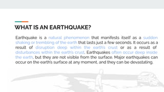
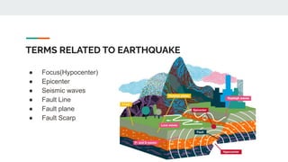
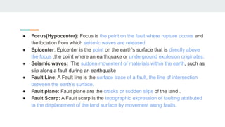
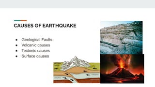
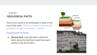
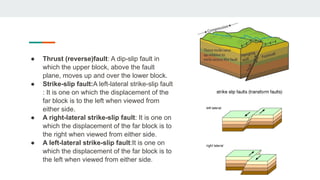
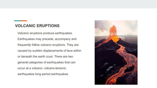
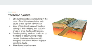
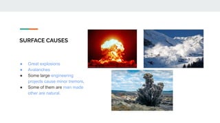
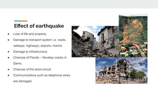
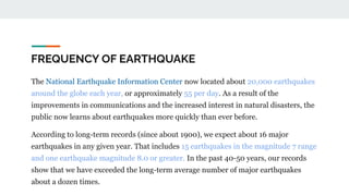
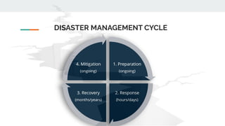
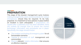
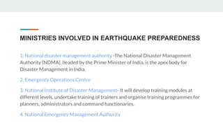
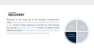
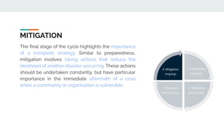
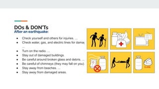
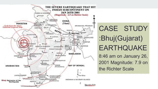
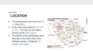
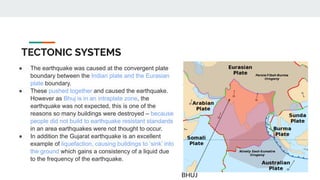
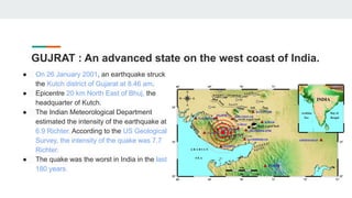
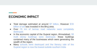
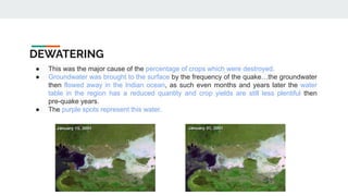
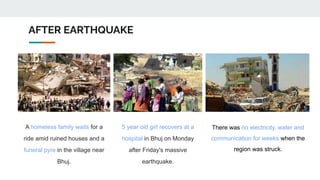
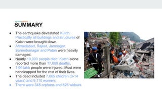
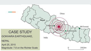
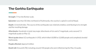
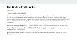
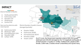
EARTHQUAKE
Md. Monis Raza
Nikhil Dhangar
Nivedita Sharma
Payal
Prakhar Srivastava
Priyanshu Tiwari
TABLE OF CONTENT
● WHAT IS AN EARTHQUAKE?
● TERMS RELATED TO EARTHQUAKE
● CAUSES OF EARTHQUAKE
● MEASUREMENT
● EFFECTS OF EARTHQUAKE
● FREQUENCY OF THE EARTHQUAKE
● DISASTER MANAGEMENT CYCLE
● DO’S AND DON'TS
● CASE STUDY- GUJARAT
● CASE STUDY- NEPAL
WHAT IS AN EARTHQUAKE?
Earthquake is a natural phenomenon that manifests itself as a sudden
shaking or trembling of the earth that lasts just a few seconds. It occurs as a
result of disruption deep within the earth’s crust or as a result of
disturbances within the earth’s crust. Earthquakes often occur deep inside
the earth, but they are not visible from the surface. Major earthquakes can
occur on the earth’s surface at any moment, and they can be devastating.
TERMS RELATED TO EARTHQUAKE
● Focus(Hypocenter)
● Epicenter
● Seismic waves
● Fault Line
● Fault plane
● Fault Scarp
● Focus(Hypocenter): Focus is the point on the fault where rupture occurs and
the location from which seismic waves are released.
● Epicenter: Epicenter is the point on the earth’s surface that is directly above
the focus ,the point where an earthquake or underground explosion originates.
● Seismic waves: The sudden movement of materials within the earth, such as
slip along a fault during an earthquake
● Fault Line: A Fault line is the surface trace of a fault, the line of intersection
between the earth’s surface.
● Fault plane: Fault plane are the cracks or sudden slips of the land .
● Fault Scarp: A Fault scarp is the topographic expression of faulting attributed
to the displacement of the land surface by movement along faults.
CAUSES OF EARTHQUAKE
● Geological Faults
● Volcanic causes
● Tectonic causes
● Surface causes
GEOLOGICAL FACTS
The primary cause of an earthquake is faults on the
crust of the earth. “A Fault is a break or fracture b/w
two blocks of rocks in response to stress.”
Classification Of Faults
● Normal fault: a dip-slip fault in which the
block above the fault has moved downward
relative to the block below.
● Thrust (reverse)fault: A dip-slip fault in
which the upper block, above the fault
plane, moves up and over the lower block.
● Strike-slip fault:A left-lateral strike-slip fault
: It is one on which the displacement of the
far block is to the left when viewed from
either side.
● A right-lateral strike-slip fault: It is one on
which the displacement of the far block is to
the right when viewed from either side.
● A left-lateral strike-slip fault:It is one on
which the displacement of the far block is to
the left when viewed from either side.
VOLCANIC ERUPTIONS
Volcanic eruptions produce earthquakes.
Earthquakes may precede, accompany and
frequently follow volcanic eruptions. They are
caused by sudden displacements of lava within
or beneath the earth crust. There are two
general categories of earthquakes that can
occur at a volcano: volcano-tectonic
earthquakes long period earthquakes.
TECTONIC CAUSES
● Structural disturbances resulting in the
parts of the lithosphere is the main
cause of this type of earthquake.
● Most of the disastrous earthquakes
belong to this category and occur in
areas of great faults and fractures.
● Sudden yielding to strain produced on
the rocks of accumulating stress
causes displacements especially
along old fault zones known as great
transform faults.
● Plate Boundary Overview.
SURFACE CAUSES
● Great explosions
● Avalanches
● Some large engineering
projects cause minor tremors.
● Some of them are man made
other are natural.
MEASUREMENT
● Seismometers are instruments that
measure motions of the ground,
including those of seismic waves
generated by earthquakes, volcanic
eruptions, and other seismic sources.
● Seismometers may be deployed at
Earth's surface, in shallow vaults, in
boreholes, or underwater.
Effect of earthquake
● Loss of life and property.
● Damage to transport system i.e. roads,
railways, highways, airports, marine
● Damage to infrastructure.
● Chances of Floods – Develop cracks in
Dams.
● Chances of fire short-circuit.
● Communications such as telephone wires
are damaged.
● Water pipes, sewers are disrupted
Economic activities like agriculture,
industry, trade and transport are
severely affected.
● Landslides
● Soil liquefaction
● Tsunami
● Floods
FREQUENCY OF EARTHQUAKE
The National Earthquake Information Center now located about 20,000 earthquakes
around the globe each year, or approximately 55 per day. As a result of the
improvements in communications and the increased interest in natural disasters, the
public now learns about earthquakes more quickly than ever before.
According to long-term records (since about 1900), we expect about 16 major
earthquakes in any given year. That includes 15 earthquakes in the magnitude 7 range
and one earthquake magnitude 8.0 or greater. In the past 40-50 years, our records
show that we have exceeded the long-term average number of major earthquakes
about a dozen times.
DISASTER MANAGEMENT CYCLE
PREPARATION
This stage of the disaster management cycle involves
making arrangements, plans and procedures for various
emergencies should they be required. To be fully
prepared, it is important to have policies in place before
an incident is even anticipated. If preparations are
started after a potential crisis has been identified, there
will unlikely be enough time to ensure the correct
technology, information and procedures are in place.
Specifically, this stage should involve:
● The creation and testing of emergency plans for all
foreseeable scenarios
● Training & education of staff, management and
communities
● Sharing relevant, helpful information that ensures
an effective response
MINISTRIES INVOLVED IN EARTHQUAKE PREPAREDNESS
1. National disaster management authority -The National Disaster Management
Authority (NDMA), headed by the Prime Minister of India, is the apex body for
Disaster Management in India.
2. Emergency Operations Centre
3. National Institute of Disaster Management- It will develop training modules at
different levels, undertake training of trainers and organise training programmes for
planners, administrators and command functionaries.
4. National Emergency Management Authority
FUNCTIONING OF
DISASTER
MANAGEMENT
COMMITTEE
GUIDELINES
RESPONSE
The second stage of the disaster management cycle,
response, encompasses actions taken during and in the
immediate aftermath of an emergency. In some cases,
action can be taken before a foreseeable incident occurs
— such as severe weather.
In principle, the response stage is designed to safeguard
staff and minimise disruption. If the third stage, recovery,
aims to return businesses & communities to a state of
normality then the goal of the initial response is to limit
how far outside of normal boundaries an incident is
capable of moving the needle
RECOVERY
Recovery is the long tail of the disaster management
cycle, measured in months or years rather than the hours
& days that an initial response is carried out over. During
this period, a coordinated effort is made to support those
affected through the restoration of infrastructure as well as
economic, social and psychological well-being.
MITIGATION
The final stage of the cycle highlights the importance
of a complete strategy. Similar to preparedness,
mitigation involves taking actions that reduce the
likelihood of another disaster occurring. These actions
should be undertaken constantly, but have particular
importance in the immediate aftermath of a crisis
when a community or organisation is vulnerable.
DOs & DON’Ts
Before an earthquake:
● Follow and advocate local safe building codes for
earthquake resistant construction.
● Follow and advocate upgrading poorly built structures.
● Make a plan and be ready for an emergency.
● Identify the medical centers, fire fighting stations and
organize rescue mock drills for the society of your area.
● Know the electric and water shut off locations in your house.
● Heavy objects, glasses, cutlery should be kept on lower
shelves.
● Flower pots should not be kept on the parapet.
DOs & DON’Ts
During an earthquake:
● Keep calm and reassure others.
● During the event, the safest place is an open space, away from buildings.
● If you are indoors, take cover under a desk, table, bed, or doorways and against inside walls and
staircase. Stay away from glass doors, glass panes, windows, or outside doors. Do not rush to go
out of the building, to avoid the stampede.
● If you are outside, move away from buildings and utility wires.
● Once in the open, stay there till the vibrations stop.
● If you are in a moving vehicle, stop as quickly as possible and stay in the vehicle.
● Free all pets and domestic animals so that they can run outside.
● Do not use candles, matches or other open flames. Put out all fires.
DOs & DON’Ts
After an earthquake:
● Check yourself and others for injuries. ...
● Check water, gas, and electric lines for damage.
...
● Turn on the radio. ...
● Stay out of damaged buildings.
● Be careful around broken glass and debris. ...
● Be careful of chimneys (they may fall on you).
● Stay away from beaches. ...
● Stay away from damaged areas.
CASE STUDY
:Bhuj(Gujarat)
EARTHQUAKE
8:46 am on January 26,
2001 Magnitude: 7.9 on
the Richter Scale
LOCATION
● The earthquake’s epicenter was 20
km from Bhuj.
● A city with a population of 140,000
in 2001. The city is in the region
known as the Kutch region.
● The effects of the earthquake were
also felt on the north side of the
Pakistan border, in Pakistan 18
people were killed.
TECTONIC SYSTEMS
● The earthquake was caused at the convergent plate
boundary between the Indian plate and the Eurasian
plate boundary.
● These pushed together and caused the earthquake.
However as Bhuj is in an intraplate zone, the
earthquake was not expected, this is one of the
reasons so many buildings were destroyed – because
people did not build to earthquake resistant standards
in an area earthquakes were not thought to occur.
● In addition the Gujarat earthquake is an excellent
example of liquefaction, causing buildings to ‘sink’ into
the ground which gains a consistency of a liquid due
to the frequency of the earthquake.
BHUJ
GUJRAT : An advanced state on the west coast of India.
● On 26 January 2001, an earthquake struck
the Kutch district of Gujarat at 8.46 am.
● Epicentre 20 km North East of Bhuj, the
headquarter of Kutch.
● The Indian Meteorological Department
estimated the intensity of the earthquake at
6.9 Richter. According to the US Geological
Survey, the intensity of the quake was 7.7
Richter.
● The quake was the worst in India in the last
180 years.
WHAT IT DID
● Casualties: loss of life and injury.
● Loss of housing.
● Damage to infrastructure.
● Disruption of transport and communications.
● Panic Looting.
● Breakdown of social order.
● Loss of industrial output.
● Loss of business.
● Disruption of marketing systems
https://gifer.com/en/7TZP
DISASTER LOSS
● Initial estimate Rs. 200 billion.
● Came down to Rs. 144 billion.
● No inventory of buildings
● Non-engineered buildings
● Land and buildings
● Stocks and flows
● Reconstruction costs (Rs. 106 billion) and loss
estimates (Rs. 99 billion) are different
● Public good considerations
HUMAN IMPACT: Effects
● Affected 15.9 million people out of 37.8 in the region (in
areas such as Bhuj, Bhachau, Anjar, Gandhidham, Rapar)
● High demand for food, water, and medical care for survivors
● Humanitarian intervention by groups such as Oxfam:
focused on Immediate response and then rehabilitation
● Of survivors, many require persistent medical attention
● Region continues to require assistance long after quake has
subsided
● International aid vital to recovery
https://c.ndtvimg.com/2023-02/fjq5g94_syria-earthquake-pt
i-650-_650x400_06_February_23.gif
SOCIAL IMPACT
● However at the same time, looting and violence occurred following the
quake, and this affected many people too.
● On the other hand, the earthquake resulted in millions of USD in aid,
which has since allowed the Bhuj region to rebuild itself and then grow in a
way it wouldn’t have done otherwise.
● The final major social effect was that around 400,000 Indian homes were
destroyed resulting in around 2 million people being made homeless
immediately following the quake.
● 80% of water and food sources were destroyed.
● The obvious social impacts are that around 20,000 people were killed and
near 200,000 were injured
https://media.tenor.com/1ZSJtcMdTdYAAAAC/earthqu
ake-natural-disaster.gif
ECONOMIC IMPACT
● Total damage estimated at around $7 billion. However $18
billion of aid was invested in the Bhuj area.
● Over 15 km of tarmac road networks were completely
destroyed.
● In the economic capital of the Gujarat region, Ahmedabad, 58
multi storey buildings were destroyed, these buildings
contained many of the businesses which were generating the
wealth of the region.
● Many schools were destroyed and the literacy rate of the
Gujarat region is now the lowest outside southern India
DEWATERING
● This was the major cause of the percentage of crops which were destroyed.
● Groundwater was brought to the surface by the frequency of the quake…the groundwater
then flowed away in the Indian ocean, as such even months and years later the water
table in the region has a reduced quantity and crop yields are still less plentiful then
pre-quake years.
● The purple spots represent this water.
AFTER EARTHQUAKE
A homeless family waits for a
ride amid ruined houses and a
funeral pyre in the village near
Bhuj.
5 year old girl recovers at a
hospital in Bhuj on Monday
after Friday's massive
earthquake.
There was no electricity, water and
communication for weeks when the
region was struck.
SUMMARY
● The earthquake devastated Kutch.
Practically all buildings and structures of
Kutch were brought down.
● Ahmedabad, Rajkot, Jamnagar,
Surendranagar and Patan were heavily
damaged.
● Nearly 19,000 people died. Kutch alone
reported more than 17,000 deaths.
● 1.66 lakh people were injured. Most were
handicapped for the rest of their lives.
● The dead included 7,065 children (0-14
years) and 9,110 women.
● There were 348 orphans and 826 widows
REFERENCES
● https://www.researchgate.net/publication/5200392_Economic_consequences_of_the_Gujarat_ea
rthquake
● https://www.researchgate.net/figure/Tectonic-map-of-Bhuj-region-with-GPS-locations-triangles-
used-for-the-present-study_fig8_229730475
● https://onlineasdma.assam.gov.in/kmp/pdf/1485522164csq1004.pdf
CASE STUDY
GOKHARA EARTHQUAKE,
NEPAL
April 25, 2015
Magnitude: 7.8 on the Richter Scale
CAUSES
The subduction of Indian plate below Eurasian
plate caused Nepal earthquake at the belt of
Himalaya. April 25 and May 12, 2015
earthquakes had occurred on the northern
boundary of the Indian plate which is under
thrusting the Eurasian plate.
The main cause of Nepal earthquakes is
attributed to the northward movement of
Indian plate. The Indian plate is moving toward
north- northeast ward direction at an average
rate of about 4.5-5 cm per annum.
On 25th April 2015, the stress built up as the
Indian and Eurasian plates slide under one
other causing earthquake. The earthquake was
caused at the depth of 10 kilometres. The 188
aftershocks measuring around 3.0-6.9
magnitude in Richter scale were at the depths
of 10-50 kilometres. After the major
earthquake, the earth's plates lost their
equilibrium. The aftershocks are basically
nature’s way to help earth get back its
equilibrium.
The Gorkha Earthquake
Strength: 7.9 on the Richter scale.
Epicenter: Less than 50 miles northwest of Kathmandu, the country’s capital in central Nepal.
Depth: 11 km/6.8 miles. The source of the earthquake was relatively shallow, contributing to its strength
and the resulting damage.
Aftershocks: Hundreds in total; two major aftershocks of 6.6 and 6.7 magnitude, and a second 7.3
magnitude quake on May 12.
Worst quake since: 8.2 earthquake in 1932, which killed 10,000 to 12,000 people and completely leveled
Kathmandu.
People affected: Approx 8 million
Death toll: Around 8,700, including around 150 people who were killed during the May 12 quake.
The Gorkha Earthquake
People injured: At least 22,200
Damage: Homes and historic temples crumbled, roads damaged and communications made sporadic.
Avalanches on Mt. Everest. We received reports from more remote areas that entire villages were
destroyed without a single home left standing. Water systems in hillside villages were wrecked. Terraced
farms and cattle were wiped out by the quake or subsequent landslides, destroying people's entire
livelihoods.
Number of homes destroyed: More than 505,000 of which 279,000 were damaged rest are shattered.
Areas affected: 40 percent of Nepal. 39 out of 75 districts reported damage. Deaths were also reported
in neighboring Tibet and India.
Most affected areas: Gorkha, Lamjung and Sindhupalchok as well as Kathmandu, Bhaktapur, Lalitpur
Districts.
IMPACT
District Number of public’s houses
damaged (partially)
● Dolakha 35000
● Kathmandu 20300
● Kavrepalanchok 18545
● Nuwakot 15000
● Tanahu 12927
District Number of deaths
● Sindhupalchok 2071
● Kathmandu 1144
● Nuwakot 759
● Dhading 636
● Gorkha 410
Here are five districts with
most injured:
● Kathmandu 4634
● Bhaktapur 1885
● Kavrepalanchok 1394
● Nuwakot 1300
● Lalitpur 1090
As of 3 June, the Government reported a total of 505,745 houses
destroyed and 279,330 damaged by the 7.8 magnitude earthquake on
25 April and the 7.3 quake on 12 May. It killed 8,702. people (4,801
female; 3,899 male; 2 bodies remain unidentified) and injured many.
ECONOMIC IMPACT
Overall economic growth in FY 2014/15, which
had previously been estimated to hit 6%, was
confined to just 3%.
According to Post Disaster Needs Assessment
{PDNA) estimates, the cumulative damage and
loss amount to 33.3% of GDP (USD 7.1 billion) and
the cumulative need for recovery is estimated to
be USD 6.7 billion (31.5% of GDP).
Manufacturing and infrastructure clusters need
17.3% and 11.1% respectively. These amount to
roughly 5.5% and 3.5% of GDP respectively.
The recovery needs requirement for agriculture,
education, electricity, and transport is estimated
at USD 156 million, USD 397 million, USD 186
million and USD 282 million respectively.
Furthermore, recovery of the tourism sector 25
and restoration of cultural heritage sites are
estimated to total USD 387 million and USD 206
million respectively.
RESPONSE & RESCUE
First few days following the earthquake, the first
responders were members of local communities, along with
Nepalis from across the country.
On 29 April, the Humanitarian Country Team launched the
Nepal Earthquake Flash Appeal to provide protection and
relief to 2.8 million people. Under the Flash Appeal, from
April to September 2015, humanitarian assistance reached
3.7 million people.
National Emergency Operation Centre (NEOC) at the
Ministry of Home Affairs was activated at level-IV by
following the National Disaster Response Framework, 2014
and Standard Operating Procedure (SoP). The Prime
Minister, Home Minister, other Ministers, Chief Secretary,
Secretaries, high level officials and the Chief of security
forces were present at the NEOC. Within two hours, the
CNDRC meeting was held for immediate relief and
response. Soon after, the cabinet meeting endorsed the
decisions of CNDRC including declaration of catastrophic
area and appealed for international assistance.
Helicopters were used in remote areas for SAR operation from Nepal Army, SAR
teams from India, China, U.S.A. and private sector. Altogether 66,069 Nepal Army
personnel, 41,776 Nepal Police, 24,775 Armed Police Force and 22,500 Civil
Servants were mobilized for response. In total 7,606 people were rescued by
4,299 flights of Nepal Army, foreign and private sector helicopters. A total of
12,295 people were rescued by air lift and land routes.
CHALLENGES AND GAPS
● Search and Rescue (SAR) works carried out by the security personnel of Nepal and foreign SAR
teams was slow and inadequate while they failed to reach in due time in the remote, rural and hilly
areas.
● Delay and serious lapse in damage and need assessment was felt all the time, Although high
number of international SAR team.
● The cost incurred for the foreign team was quite huge. So it can be assessed that the return was
quite low in comparison to the investment upon the foreign team.
● Even after the response phase, some International Search and Rescue Teams remained
unnecessarily for a prolonged time causing burden to the national response system.
● Emergency warehouses, prepositioning of relief materials with proper inventory were also lacking.
● Debris management was found as one of the big problem basically because of the lack of debris
management equipment, tools and techniques.
● Open spaces for temporary settlement of the displaced population were lacking.
● Initially, there was a gap between the need of the affected people and delivery of services.
● Weak database, absence of modern technology and lack of SAR equipment were other bottlenecks
for response.
RECOVERY
The FY2016 budget is primarily focused on rehabilitation and
reconstruction of physical and social infrastructure, housing and
livelihoods after the catastrophic earthquake. Reconstruction work is
scheduled to be completed within the next five years.
the Legislature-Parliament has passed an act which deals with the
reconstruction of earthquake-affected infrastructures and established
a National Reconstruction Authority(NRA).
The NRA has already prepared a recovery framework on
post-earthquake reconstruction in line with the Post Disaster Needs
Assessment, aims to complete reconstruction as soon as possible. The
committee has also approved INR 290 million for administrative
expenditure
The NRA has also authorised a central project implementation under a
local development ministry to distribute a relief fund amounting to
USD 2.49 million. This will help conduct the relief operation based in
Singati, which is in Dolakha district
GOVERNMENT GUIDELINES
TO PREVENT EARTHQUAKE
Some Important measures to prevent and mitigate earthquake loss
The National Center for Seismology
● An office of the Ministry of Earth Sciences.
● It submits earthquake surveillance and hazard reports to governmental agencies.
● It includes three divisions:
1. Earthquake Monitoring & Services,
2. Risk Assessment
3. Geophysical Observation System.
GOVERNMENT GUIDELINES
TO PREVENT EARTHQUAKE
National Earthquake Risk Mitigation Project (NERMP)
● Strengthening the structural and non-structural dimensions of earthquake
mitigation efforts.
● Reducing the vulnerability in the high-risk districts.
● Necessary risk mitigation measures are put in place in the highly seismic zones.
● NDMA, tasked with this project has prepared a Detailed Project Report (DPR).
GOVERNMENT GUIDELINES
TO PREVENT EARTHQUAKE
National Building Code (NBC)
● Comprehensive building code and a national instrument providing guidelines for
regulating the building construction activities across the country.
GOVERNMENT GUIDELINES
TO PREVENT EARTHQUAKE
Building Materials & Technology Promotion Council (BMTPC)
● Undertakes projects for retrofitting of life-line structures to generate
awareness among the people and various government agencies.
● Aimed to help people at large and the policymakers in particular in working
towards reducing the vulnerability of lakhs of existing public and private
buildings.
GOVERNMENT GUIDELINES
TO PREVENT EARTHQUAKE
Initiatives by Ministry of Panchayati Raj
● It releases funds under Backward Regions Grant Fund (BRGF) for meeting critical
infrastructural gaps and other developmental requirements.
● The ministry has financed several district plans under the BRGF for construction of
panchayat buildings, Anganwadi centres, school buildings, classrooms, roads, bridges,
culverts, etc. and restructuring of State Institutes for Rural Development (SIRD) buildings,
block resource centres, panchayat training centers, etc.
GOVERNMENT GUIDELINES
TO PREVENT EARTHQUAKE
The government launched two Mobile apps
● ‘India Quake’– Developed by the National center for seismology, the mobile app disseminates
real-time earthquake information.
●
● ‘Sagar Vani’-Intended to serve coastal communities, the mobile app disseminates ocean
related information and alerts to the user community in a timely manner for their safety.
EARTHQUAKE ZONES IN
INDIA
ZONES ARE SUBDIVIDED INTO FIVE TYPES
1. ZONE 5
2. ZONE 4
3. ZONE 3
4. ZONE 2
5. ZONE 1
ZONE V
● Zone 5 covers the areas with the highest risk of suffering
earthquakes of intensity
● The regions of Kashmir, the Western and Central Himalayas, North
and Middle Bihar, the North-East Indian region, the Rann of Kutch
and the Andaman and Nicobar group of islands fall in this zone.
ZONE IV
● This zone is called the High Damage Risk Zone and covers areas liable to MSK
VIII
● Jammu and Kashmir, Ladakh, Himachal Pradesh, Uttarakhand, Sikkim, parts of
the Indo-Gangetic plains (North Punjab, Chandigarh, Western Uttar Pradesh,
Terai, a major portion of Bihar, North Bengal, the Sundarbans) and the capital of
the country Delhi fall in Zone 4.
ZONE III
This zone is classified as a Moderate Damage Risk Zone which is liable to
MSK VII. The IS code assigns a zone factor of 0.16 for Zone 3. Several
megacities like Chennai, Mumbai,Kolkata and Bhubaneshwar lie in this
zone.
ZONE II
This region is liable to MSK VI or lower and is classified as the Low
Damage Risk Zone. The IS code assigns a zone factor of 0.10 for
Zone 2. It is the zone with low chances of having earthquakes. Cities
like Bangalore,coromandel coast and Tiruchirappalli are in this zone.
ZONE I
Since the current division of India into earthquake hazard
zones does not use Zone 1, no area of India is classed as
Zone 1.
BIBLIOGRAPHY
● https://www.britannica.com/event/Nepal-earthquake-of-2015
● "Nepal Earthquake 2015: What happened and why." BBC News. https://www.bbc.com/news/world-asia-32461019
● "International response to the 2015 Nepal earthquake." Wikipedia.
https://en.wikipedia.org/wiki/International_response_to_the_2015_Nepal_earthquake
● "Nepal's earthquake-resistant building codes: Good progress, but challenges ahead." World Bank.
https://www.worldbank.org/en/news/feature/2018/04/25/nepals-earthquake-resistant-building-codes-good-progres
s-but-challenges-ahead
● "Building back safer: Nepal's new earthquake-resistant homes." The Guardian.
https://www.theguardian.com/world/2016/may/06/building-back-safer-nepals-new-earthquake-resistant-homes
● "Post-disaster reconstruction planning in Nepal: Experiences, challenges and opportunities." International Journal of
Disaster Risk Reduction. https://www.sciencedirect.com/science/article/pii/S2212420917302018
● "Community-driven reconstruction in Nepal." International Institute for Environment and Development.
https://www.iied.org/community-driven-reconstruction-nepal

Earthquake .pdf

  • 1.
    EARTHQUAKE Md. Monis Raza NikhilDhangar Nivedita Sharma Payal Prakhar Srivastava Priyanshu Tiwari
  • 2.
    TABLE OF CONTENT ●WHAT IS AN EARTHQUAKE? ● TERMS RELATED TO EARTHQUAKE ● CAUSES OF EARTHQUAKE ● MEASUREMENT ● EFFECTS OF EARTHQUAKE ● FREQUENCY OF THE EARTHQUAKE ● DISASTER MANAGEMENT CYCLE ● DO’S AND DON'TS ● CASE STUDY- GUJARAT ● CASE STUDY- NEPAL
  • 3.
    WHAT IS ANEARTHQUAKE? Earthquake is a natural phenomenon that manifests itself as a sudden shaking or trembling of the earth that lasts just a few seconds. It occurs as a result of disruption deep within the earth’s crust or as a result of disturbances within the earth’s crust. Earthquakes often occur deep inside the earth, but they are not visible from the surface. Major earthquakes can occur on the earth’s surface at any moment, and they can be devastating.
  • 4.
    TERMS RELATED TOEARTHQUAKE ● Focus(Hypocenter) ● Epicenter ● Seismic waves ● Fault Line ● Fault plane ● Fault Scarp
  • 5.
    ● Focus(Hypocenter): Focusis the point on the fault where rupture occurs and the location from which seismic waves are released. ● Epicenter: Epicenter is the point on the earth’s surface that is directly above the focus ,the point where an earthquake or underground explosion originates. ● Seismic waves: The sudden movement of materials within the earth, such as slip along a fault during an earthquake ● Fault Line: A Fault line is the surface trace of a fault, the line of intersection between the earth’s surface. ● Fault plane: Fault plane are the cracks or sudden slips of the land . ● Fault Scarp: A Fault scarp is the topographic expression of faulting attributed to the displacement of the land surface by movement along faults.
  • 6.
    CAUSES OF EARTHQUAKE ●Geological Faults ● Volcanic causes ● Tectonic causes ● Surface causes
  • 7.
    GEOLOGICAL FACTS The primarycause of an earthquake is faults on the crust of the earth. “A Fault is a break or fracture b/w two blocks of rocks in response to stress.” Classification Of Faults ● Normal fault: a dip-slip fault in which the block above the fault has moved downward relative to the block below.
  • 8.
    ● Thrust (reverse)fault:A dip-slip fault in which the upper block, above the fault plane, moves up and over the lower block. ● Strike-slip fault:A left-lateral strike-slip fault : It is one on which the displacement of the far block is to the left when viewed from either side. ● A right-lateral strike-slip fault: It is one on which the displacement of the far block is to the right when viewed from either side. ● A left-lateral strike-slip fault:It is one on which the displacement of the far block is to the left when viewed from either side.
  • 9.
    VOLCANIC ERUPTIONS Volcanic eruptionsproduce earthquakes. Earthquakes may precede, accompany and frequently follow volcanic eruptions. They are caused by sudden displacements of lava within or beneath the earth crust. There are two general categories of earthquakes that can occur at a volcano: volcano-tectonic earthquakes long period earthquakes.
  • 10.
    TECTONIC CAUSES ● Structuraldisturbances resulting in the parts of the lithosphere is the main cause of this type of earthquake. ● Most of the disastrous earthquakes belong to this category and occur in areas of great faults and fractures. ● Sudden yielding to strain produced on the rocks of accumulating stress causes displacements especially along old fault zones known as great transform faults. ● Plate Boundary Overview.
  • 11.
    SURFACE CAUSES ● Greatexplosions ● Avalanches ● Some large engineering projects cause minor tremors. ● Some of them are man made other are natural.
  • 12.
    MEASUREMENT ● Seismometers areinstruments that measure motions of the ground, including those of seismic waves generated by earthquakes, volcanic eruptions, and other seismic sources. ● Seismometers may be deployed at Earth's surface, in shallow vaults, in boreholes, or underwater.
  • 13.
    Effect of earthquake ●Loss of life and property. ● Damage to transport system i.e. roads, railways, highways, airports, marine ● Damage to infrastructure. ● Chances of Floods – Develop cracks in Dams. ● Chances of fire short-circuit. ● Communications such as telephone wires are damaged.
  • 14.
    ● Water pipes,sewers are disrupted Economic activities like agriculture, industry, trade and transport are severely affected. ● Landslides ● Soil liquefaction ● Tsunami ● Floods
  • 15.
    FREQUENCY OF EARTHQUAKE TheNational Earthquake Information Center now located about 20,000 earthquakes around the globe each year, or approximately 55 per day. As a result of the improvements in communications and the increased interest in natural disasters, the public now learns about earthquakes more quickly than ever before. According to long-term records (since about 1900), we expect about 16 major earthquakes in any given year. That includes 15 earthquakes in the magnitude 7 range and one earthquake magnitude 8.0 or greater. In the past 40-50 years, our records show that we have exceeded the long-term average number of major earthquakes about a dozen times.
  • 16.
  • 17.
    PREPARATION This stage ofthe disaster management cycle involves making arrangements, plans and procedures for various emergencies should they be required. To be fully prepared, it is important to have policies in place before an incident is even anticipated. If preparations are started after a potential crisis has been identified, there will unlikely be enough time to ensure the correct technology, information and procedures are in place. Specifically, this stage should involve: ● The creation and testing of emergency plans for all foreseeable scenarios ● Training & education of staff, management and communities ● Sharing relevant, helpful information that ensures an effective response
  • 18.
    MINISTRIES INVOLVED INEARTHQUAKE PREPAREDNESS 1. National disaster management authority -The National Disaster Management Authority (NDMA), headed by the Prime Minister of India, is the apex body for Disaster Management in India. 2. Emergency Operations Centre 3. National Institute of Disaster Management- It will develop training modules at different levels, undertake training of trainers and organise training programmes for planners, administrators and command functionaries. 4. National Emergency Management Authority
  • 19.
  • 20.
  • 21.
    RESPONSE The second stageof the disaster management cycle, response, encompasses actions taken during and in the immediate aftermath of an emergency. In some cases, action can be taken before a foreseeable incident occurs — such as severe weather. In principle, the response stage is designed to safeguard staff and minimise disruption. If the third stage, recovery, aims to return businesses & communities to a state of normality then the goal of the initial response is to limit how far outside of normal boundaries an incident is capable of moving the needle
  • 22.
    RECOVERY Recovery is thelong tail of the disaster management cycle, measured in months or years rather than the hours & days that an initial response is carried out over. During this period, a coordinated effort is made to support those affected through the restoration of infrastructure as well as economic, social and psychological well-being.
  • 23.
    MITIGATION The final stageof the cycle highlights the importance of a complete strategy. Similar to preparedness, mitigation involves taking actions that reduce the likelihood of another disaster occurring. These actions should be undertaken constantly, but have particular importance in the immediate aftermath of a crisis when a community or organisation is vulnerable.
  • 24.
    DOs & DON’Ts Beforean earthquake: ● Follow and advocate local safe building codes for earthquake resistant construction. ● Follow and advocate upgrading poorly built structures. ● Make a plan and be ready for an emergency. ● Identify the medical centers, fire fighting stations and organize rescue mock drills for the society of your area. ● Know the electric and water shut off locations in your house. ● Heavy objects, glasses, cutlery should be kept on lower shelves. ● Flower pots should not be kept on the parapet.
  • 25.
    DOs & DON’Ts Duringan earthquake: ● Keep calm and reassure others. ● During the event, the safest place is an open space, away from buildings. ● If you are indoors, take cover under a desk, table, bed, or doorways and against inside walls and staircase. Stay away from glass doors, glass panes, windows, or outside doors. Do not rush to go out of the building, to avoid the stampede. ● If you are outside, move away from buildings and utility wires. ● Once in the open, stay there till the vibrations stop. ● If you are in a moving vehicle, stop as quickly as possible and stay in the vehicle. ● Free all pets and domestic animals so that they can run outside. ● Do not use candles, matches or other open flames. Put out all fires.
  • 26.
    DOs & DON’Ts Afteran earthquake: ● Check yourself and others for injuries. ... ● Check water, gas, and electric lines for damage. ... ● Turn on the radio. ... ● Stay out of damaged buildings. ● Be careful around broken glass and debris. ... ● Be careful of chimneys (they may fall on you). ● Stay away from beaches. ... ● Stay away from damaged areas.
  • 27.
    CASE STUDY :Bhuj(Gujarat) EARTHQUAKE 8:46 amon January 26, 2001 Magnitude: 7.9 on the Richter Scale
  • 28.
    LOCATION ● The earthquake’sepicenter was 20 km from Bhuj. ● A city with a population of 140,000 in 2001. The city is in the region known as the Kutch region. ● The effects of the earthquake were also felt on the north side of the Pakistan border, in Pakistan 18 people were killed.
  • 29.
    TECTONIC SYSTEMS ● Theearthquake was caused at the convergent plate boundary between the Indian plate and the Eurasian plate boundary. ● These pushed together and caused the earthquake. However as Bhuj is in an intraplate zone, the earthquake was not expected, this is one of the reasons so many buildings were destroyed – because people did not build to earthquake resistant standards in an area earthquakes were not thought to occur. ● In addition the Gujarat earthquake is an excellent example of liquefaction, causing buildings to ‘sink’ into the ground which gains a consistency of a liquid due to the frequency of the earthquake. BHUJ
  • 30.
    GUJRAT : Anadvanced state on the west coast of India. ● On 26 January 2001, an earthquake struck the Kutch district of Gujarat at 8.46 am. ● Epicentre 20 km North East of Bhuj, the headquarter of Kutch. ● The Indian Meteorological Department estimated the intensity of the earthquake at 6.9 Richter. According to the US Geological Survey, the intensity of the quake was 7.7 Richter. ● The quake was the worst in India in the last 180 years.
  • 31.
    WHAT IT DID ●Casualties: loss of life and injury. ● Loss of housing. ● Damage to infrastructure. ● Disruption of transport and communications. ● Panic Looting. ● Breakdown of social order. ● Loss of industrial output. ● Loss of business. ● Disruption of marketing systems https://gifer.com/en/7TZP
  • 32.
    DISASTER LOSS ● Initialestimate Rs. 200 billion. ● Came down to Rs. 144 billion. ● No inventory of buildings ● Non-engineered buildings ● Land and buildings ● Stocks and flows ● Reconstruction costs (Rs. 106 billion) and loss estimates (Rs. 99 billion) are different ● Public good considerations
  • 33.
    HUMAN IMPACT: Effects ●Affected 15.9 million people out of 37.8 in the region (in areas such as Bhuj, Bhachau, Anjar, Gandhidham, Rapar) ● High demand for food, water, and medical care for survivors ● Humanitarian intervention by groups such as Oxfam: focused on Immediate response and then rehabilitation ● Of survivors, many require persistent medical attention ● Region continues to require assistance long after quake has subsided ● International aid vital to recovery https://c.ndtvimg.com/2023-02/fjq5g94_syria-earthquake-pt i-650-_650x400_06_February_23.gif
  • 34.
    SOCIAL IMPACT ● Howeverat the same time, looting and violence occurred following the quake, and this affected many people too. ● On the other hand, the earthquake resulted in millions of USD in aid, which has since allowed the Bhuj region to rebuild itself and then grow in a way it wouldn’t have done otherwise. ● The final major social effect was that around 400,000 Indian homes were destroyed resulting in around 2 million people being made homeless immediately following the quake. ● 80% of water and food sources were destroyed. ● The obvious social impacts are that around 20,000 people were killed and near 200,000 were injured https://media.tenor.com/1ZSJtcMdTdYAAAAC/earthqu ake-natural-disaster.gif
  • 35.
    ECONOMIC IMPACT ● Totaldamage estimated at around $7 billion. However $18 billion of aid was invested in the Bhuj area. ● Over 15 km of tarmac road networks were completely destroyed. ● In the economic capital of the Gujarat region, Ahmedabad, 58 multi storey buildings were destroyed, these buildings contained many of the businesses which were generating the wealth of the region. ● Many schools were destroyed and the literacy rate of the Gujarat region is now the lowest outside southern India
  • 36.
    DEWATERING ● This wasthe major cause of the percentage of crops which were destroyed. ● Groundwater was brought to the surface by the frequency of the quake…the groundwater then flowed away in the Indian ocean, as such even months and years later the water table in the region has a reduced quantity and crop yields are still less plentiful then pre-quake years. ● The purple spots represent this water.
  • 37.
    AFTER EARTHQUAKE A homelessfamily waits for a ride amid ruined houses and a funeral pyre in the village near Bhuj. 5 year old girl recovers at a hospital in Bhuj on Monday after Friday's massive earthquake. There was no electricity, water and communication for weeks when the region was struck.
  • 38.
    SUMMARY ● The earthquakedevastated Kutch. Practically all buildings and structures of Kutch were brought down. ● Ahmedabad, Rajkot, Jamnagar, Surendranagar and Patan were heavily damaged. ● Nearly 19,000 people died. Kutch alone reported more than 17,000 deaths. ● 1.66 lakh people were injured. Most were handicapped for the rest of their lives. ● The dead included 7,065 children (0-14 years) and 9,110 women. ● There were 348 orphans and 826 widows
  • 39.
  • 40.
    CASE STUDY GOKHARA EARTHQUAKE, NEPAL April25, 2015 Magnitude: 7.8 on the Richter Scale
  • 41.
    CAUSES The subduction ofIndian plate below Eurasian plate caused Nepal earthquake at the belt of Himalaya. April 25 and May 12, 2015 earthquakes had occurred on the northern boundary of the Indian plate which is under thrusting the Eurasian plate. The main cause of Nepal earthquakes is attributed to the northward movement of Indian plate. The Indian plate is moving toward north- northeast ward direction at an average rate of about 4.5-5 cm per annum. On 25th April 2015, the stress built up as the Indian and Eurasian plates slide under one other causing earthquake. The earthquake was caused at the depth of 10 kilometres. The 188 aftershocks measuring around 3.0-6.9 magnitude in Richter scale were at the depths of 10-50 kilometres. After the major earthquake, the earth's plates lost their equilibrium. The aftershocks are basically nature’s way to help earth get back its equilibrium.
  • 42.
    The Gorkha Earthquake Strength:7.9 on the Richter scale. Epicenter: Less than 50 miles northwest of Kathmandu, the country’s capital in central Nepal. Depth: 11 km/6.8 miles. The source of the earthquake was relatively shallow, contributing to its strength and the resulting damage. Aftershocks: Hundreds in total; two major aftershocks of 6.6 and 6.7 magnitude, and a second 7.3 magnitude quake on May 12. Worst quake since: 8.2 earthquake in 1932, which killed 10,000 to 12,000 people and completely leveled Kathmandu. People affected: Approx 8 million Death toll: Around 8,700, including around 150 people who were killed during the May 12 quake.
  • 43.
    The Gorkha Earthquake Peopleinjured: At least 22,200 Damage: Homes and historic temples crumbled, roads damaged and communications made sporadic. Avalanches on Mt. Everest. We received reports from more remote areas that entire villages were destroyed without a single home left standing. Water systems in hillside villages were wrecked. Terraced farms and cattle were wiped out by the quake or subsequent landslides, destroying people's entire livelihoods. Number of homes destroyed: More than 505,000 of which 279,000 were damaged rest are shattered. Areas affected: 40 percent of Nepal. 39 out of 75 districts reported damage. Deaths were also reported in neighboring Tibet and India. Most affected areas: Gorkha, Lamjung and Sindhupalchok as well as Kathmandu, Bhaktapur, Lalitpur Districts.
  • 44.
    IMPACT District Number ofpublic’s houses damaged (partially) ● Dolakha 35000 ● Kathmandu 20300 ● Kavrepalanchok 18545 ● Nuwakot 15000 ● Tanahu 12927 District Number of deaths ● Sindhupalchok 2071 ● Kathmandu 1144 ● Nuwakot 759 ● Dhading 636 ● Gorkha 410 Here are five districts with most injured: ● Kathmandu 4634 ● Bhaktapur 1885 ● Kavrepalanchok 1394 ● Nuwakot 1300 ● Lalitpur 1090 As of 3 June, the Government reported a total of 505,745 houses destroyed and 279,330 damaged by the 7.8 magnitude earthquake on 25 April and the 7.3 quake on 12 May. It killed 8,702. people (4,801 female; 3,899 male; 2 bodies remain unidentified) and injured many.
  • 45.
    ECONOMIC IMPACT Overall economicgrowth in FY 2014/15, which had previously been estimated to hit 6%, was confined to just 3%. According to Post Disaster Needs Assessment {PDNA) estimates, the cumulative damage and loss amount to 33.3% of GDP (USD 7.1 billion) and the cumulative need for recovery is estimated to be USD 6.7 billion (31.5% of GDP). Manufacturing and infrastructure clusters need 17.3% and 11.1% respectively. These amount to roughly 5.5% and 3.5% of GDP respectively. The recovery needs requirement for agriculture, education, electricity, and transport is estimated at USD 156 million, USD 397 million, USD 186 million and USD 282 million respectively. Furthermore, recovery of the tourism sector 25 and restoration of cultural heritage sites are estimated to total USD 387 million and USD 206 million respectively.
  • 46.
    RESPONSE & RESCUE Firstfew days following the earthquake, the first responders were members of local communities, along with Nepalis from across the country. On 29 April, the Humanitarian Country Team launched the Nepal Earthquake Flash Appeal to provide protection and relief to 2.8 million people. Under the Flash Appeal, from April to September 2015, humanitarian assistance reached 3.7 million people. National Emergency Operation Centre (NEOC) at the Ministry of Home Affairs was activated at level-IV by following the National Disaster Response Framework, 2014 and Standard Operating Procedure (SoP). The Prime Minister, Home Minister, other Ministers, Chief Secretary, Secretaries, high level officials and the Chief of security forces were present at the NEOC. Within two hours, the CNDRC meeting was held for immediate relief and response. Soon after, the cabinet meeting endorsed the decisions of CNDRC including declaration of catastrophic area and appealed for international assistance. Helicopters were used in remote areas for SAR operation from Nepal Army, SAR teams from India, China, U.S.A. and private sector. Altogether 66,069 Nepal Army personnel, 41,776 Nepal Police, 24,775 Armed Police Force and 22,500 Civil Servants were mobilized for response. In total 7,606 people were rescued by 4,299 flights of Nepal Army, foreign and private sector helicopters. A total of 12,295 people were rescued by air lift and land routes.
  • 47.
    CHALLENGES AND GAPS ●Search and Rescue (SAR) works carried out by the security personnel of Nepal and foreign SAR teams was slow and inadequate while they failed to reach in due time in the remote, rural and hilly areas. ● Delay and serious lapse in damage and need assessment was felt all the time, Although high number of international SAR team. ● The cost incurred for the foreign team was quite huge. So it can be assessed that the return was quite low in comparison to the investment upon the foreign team. ● Even after the response phase, some International Search and Rescue Teams remained unnecessarily for a prolonged time causing burden to the national response system. ● Emergency warehouses, prepositioning of relief materials with proper inventory were also lacking. ● Debris management was found as one of the big problem basically because of the lack of debris management equipment, tools and techniques. ● Open spaces for temporary settlement of the displaced population were lacking. ● Initially, there was a gap between the need of the affected people and delivery of services. ● Weak database, absence of modern technology and lack of SAR equipment were other bottlenecks for response.
  • 48.
    RECOVERY The FY2016 budgetis primarily focused on rehabilitation and reconstruction of physical and social infrastructure, housing and livelihoods after the catastrophic earthquake. Reconstruction work is scheduled to be completed within the next five years. the Legislature-Parliament has passed an act which deals with the reconstruction of earthquake-affected infrastructures and established a National Reconstruction Authority(NRA). The NRA has already prepared a recovery framework on post-earthquake reconstruction in line with the Post Disaster Needs Assessment, aims to complete reconstruction as soon as possible. The committee has also approved INR 290 million for administrative expenditure The NRA has also authorised a central project implementation under a local development ministry to distribute a relief fund amounting to USD 2.49 million. This will help conduct the relief operation based in Singati, which is in Dolakha district
  • 49.
    GOVERNMENT GUIDELINES TO PREVENTEARTHQUAKE Some Important measures to prevent and mitigate earthquake loss The National Center for Seismology ● An office of the Ministry of Earth Sciences. ● It submits earthquake surveillance and hazard reports to governmental agencies. ● It includes three divisions: 1. Earthquake Monitoring & Services, 2. Risk Assessment 3. Geophysical Observation System.
  • 50.
    GOVERNMENT GUIDELINES TO PREVENTEARTHQUAKE National Earthquake Risk Mitigation Project (NERMP) ● Strengthening the structural and non-structural dimensions of earthquake mitigation efforts. ● Reducing the vulnerability in the high-risk districts. ● Necessary risk mitigation measures are put in place in the highly seismic zones. ● NDMA, tasked with this project has prepared a Detailed Project Report (DPR).
  • 51.
    GOVERNMENT GUIDELINES TO PREVENTEARTHQUAKE National Building Code (NBC) ● Comprehensive building code and a national instrument providing guidelines for regulating the building construction activities across the country.
  • 52.
    GOVERNMENT GUIDELINES TO PREVENTEARTHQUAKE Building Materials & Technology Promotion Council (BMTPC) ● Undertakes projects for retrofitting of life-line structures to generate awareness among the people and various government agencies. ● Aimed to help people at large and the policymakers in particular in working towards reducing the vulnerability of lakhs of existing public and private buildings.
  • 53.
    GOVERNMENT GUIDELINES TO PREVENTEARTHQUAKE Initiatives by Ministry of Panchayati Raj ● It releases funds under Backward Regions Grant Fund (BRGF) for meeting critical infrastructural gaps and other developmental requirements. ● The ministry has financed several district plans under the BRGF for construction of panchayat buildings, Anganwadi centres, school buildings, classrooms, roads, bridges, culverts, etc. and restructuring of State Institutes for Rural Development (SIRD) buildings, block resource centres, panchayat training centers, etc.
  • 54.
    GOVERNMENT GUIDELINES TO PREVENTEARTHQUAKE The government launched two Mobile apps ● ‘India Quake’– Developed by the National center for seismology, the mobile app disseminates real-time earthquake information. ● ● ‘Sagar Vani’-Intended to serve coastal communities, the mobile app disseminates ocean related information and alerts to the user community in a timely manner for their safety.
  • 55.
    EARTHQUAKE ZONES IN INDIA ZONESARE SUBDIVIDED INTO FIVE TYPES 1. ZONE 5 2. ZONE 4 3. ZONE 3 4. ZONE 2 5. ZONE 1
  • 56.
    ZONE V ● Zone5 covers the areas with the highest risk of suffering earthquakes of intensity ● The regions of Kashmir, the Western and Central Himalayas, North and Middle Bihar, the North-East Indian region, the Rann of Kutch and the Andaman and Nicobar group of islands fall in this zone.
  • 57.
    ZONE IV ● Thiszone is called the High Damage Risk Zone and covers areas liable to MSK VIII ● Jammu and Kashmir, Ladakh, Himachal Pradesh, Uttarakhand, Sikkim, parts of the Indo-Gangetic plains (North Punjab, Chandigarh, Western Uttar Pradesh, Terai, a major portion of Bihar, North Bengal, the Sundarbans) and the capital of the country Delhi fall in Zone 4.
  • 58.
    ZONE III This zoneis classified as a Moderate Damage Risk Zone which is liable to MSK VII. The IS code assigns a zone factor of 0.16 for Zone 3. Several megacities like Chennai, Mumbai,Kolkata and Bhubaneshwar lie in this zone.
  • 59.
    ZONE II This regionis liable to MSK VI or lower and is classified as the Low Damage Risk Zone. The IS code assigns a zone factor of 0.10 for Zone 2. It is the zone with low chances of having earthquakes. Cities like Bangalore,coromandel coast and Tiruchirappalli are in this zone.
  • 60.
    ZONE I Since thecurrent division of India into earthquake hazard zones does not use Zone 1, no area of India is classed as Zone 1.
  • 61.
    BIBLIOGRAPHY ● https://www.britannica.com/event/Nepal-earthquake-of-2015 ● "NepalEarthquake 2015: What happened and why." BBC News. https://www.bbc.com/news/world-asia-32461019 ● "International response to the 2015 Nepal earthquake." Wikipedia. https://en.wikipedia.org/wiki/International_response_to_the_2015_Nepal_earthquake ● "Nepal's earthquake-resistant building codes: Good progress, but challenges ahead." World Bank. https://www.worldbank.org/en/news/feature/2018/04/25/nepals-earthquake-resistant-building-codes-good-progres s-but-challenges-ahead ● "Building back safer: Nepal's new earthquake-resistant homes." The Guardian. https://www.theguardian.com/world/2016/may/06/building-back-safer-nepals-new-earthquake-resistant-homes ● "Post-disaster reconstruction planning in Nepal: Experiences, challenges and opportunities." International Journal of Disaster Risk Reduction. https://www.sciencedirect.com/science/article/pii/S2212420917302018 ● "Community-driven reconstruction in Nepal." International Institute for Environment and Development. https://www.iied.org/community-driven-reconstruction-nepal