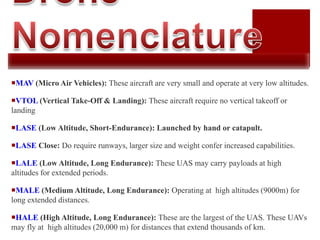
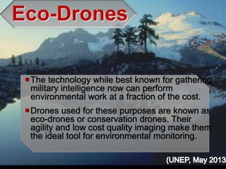
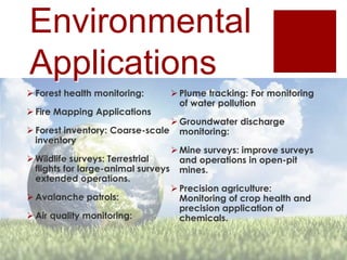
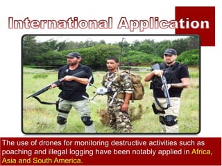
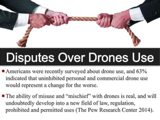
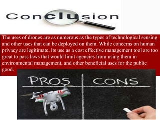
SlideShare a Scribd company logo
1 of 16
Provide an Overview of Drone Technology
Environmental Applications of Drone Technology
Other Considerations
Questions, Comments, Discussion
An aircraft with the capacity to fly
autonomously due to the support
of on board computers and
sensors.
The US military has poured
billions of dollars of research into
these high tech tools, and now
provide a low-cost option to the
commercial market.
(Source: Cielmap2012)
Anyone Can Afford Them
High quality
drones now reach
down to a price of
as little as $1,000
Drones can now
be a part of nearly
any enterprise that
can use them.
MAV (Micro Air Vehicles): These aircraft are very small and operate at very low altitudes.
VTOL (Vertical Take-Off & Landing): These aircraft require no vertical takeoff or
landing
LASE (Low Altitude, Short-Endurance): Launched by hand or catapult.
LASE Close: Do require runways, larger size and weight confer increased capabilities.
LALE (Low Altitude, Long Endurance): These UAS may carry payloads at high
altitudes for extended periods.
MALE (Medium Altitude, Long Endurance): Operating at high altitudes (9000m) for
long extended distances.
HALE (High Altitude, Long Endurance): These are the largest of the UAS. These UAVs
may fly at high altitudes (20,000 m) for distances that extend thousands of km.
Eco-Drones
The technology while best known for gathering
military intelligence now can perform
environmental work at a fraction of the cost.
Drones used for these purposes are known as
eco-drones or conservation drones. Their
agility and low cost quality imaging make them
the ideal tool for environmental monitoring.
Environmental
Applications
 Forest health monitoring:
 Fire Mapping Applications
 Forest inventory: Coarse-scale
inventory
 Wildlife surveys: Terrestrial
flights for large-animal surveys
extended operations.
 Avalanche patrols:
 Air quality monitoring:
 Plume tracking: For monitoring
of water pollution
 Groundwater discharge
monitoring:
 Mine surveys: improve surveys
and operations in open-pit
mines.
 Precision agriculture:
Monitoring of crop health and
precision application of
chemicals.
Brazil has purchased 14 drones for US$350 million for the Sao
Paul Environmental Police to monitor deforestation in the Amazon,
track poachers and seek out illegal mining operations (Cohen,
The World Wildlife Fund (WWF) has been using drones, to
monitor illicit trade in Africa by tracking poachers and the wildlife
they are pursuing in real time (WWF, 2012).
The use of drones for monitoring destructive activities such as
poaching and illegal logging have been notably applied in Africa,
Asia and South America.
Drones can be used to monitor highways vulnerable to
landslides, using high resolution cameras to detect cracks
that may indicate the onset of a landslide. Data collected from
the drone can be used by authorities to initiate early warning
allowing people to escape and those travelling to the area to
avoid the disaster event before it occurs (Hinkley and
Early Warning Applications
The use of drones for early warning of forest fires has been
tested by the US Forest Service. By collecting data on forest
fires, firefighters can better plan and manage fires. While
manned helicopters and planes could collect similar
information, the flight costs, and risks involved are high.
(Hinkley and Zajkowski, 2011)
Quick and easy deployment ability
Entering hazardous areas make drones a beneficial tool for
collecting real-time data, mapping disaster impacts as they
occur. Drones can provide real time information to
emergency planners, showing where environmental
conditions are worsening (i.e. flood spreading) and contribute
to rescue efforts. (Hinkley and Zajkowski, 2011).
 A developed system, using multispectral and electro-
optical infrared cameras is now being used by the Italian
Coast Guard for detecting illegal and unauthorized sewer
and storm-drain environmental policy violations.
(Watts, Ambrosia, Hinkley, E.A., 2012)
Infrared thermography is an ideal tool to
detect environmental contamination.
Bridge Inspections
Spatially Integrated Small-Format Aerial
Photography (SFAP) is being developed which is a
low-cost solution for bridge surface imaging and is
proposed as a remote bridge inspection technique. It
will Provide top-down views, drones flying at about
1000 feet can allow visualization of sub-inch (large)
cracks and joint openings on bridge decks or highway
pavements (Chen, S. E., Hauser, E. W., Boyle, C. G., &
Natarajan, M. 2013).
The University of Nebraska-Lincoln
and the University of California-
Berkeley were jointly awarded a
nearly $1 million grant from the US
Department of Agriculture for
developing drones that can take
water quality samples from lakes,
rivers and streams). The project is
still in the development stage, but
the helicopter-type drones can
already be deployed to collect small
volume water samples from remote(Abourezk, 2013)
 Many state and federal fish and wildlife agencies include a
law enforcement arm. Some proposed legislation is loosely-
written, and severely limits the use of drones by “law
enforcement agencies” (The Pew Research Center 2014).
 Politicians tend to follow public sentiment, thus increased
awareness of drones has resulted in numerous bills being
introduced in various state legislatures seeking to limit their
use. Between the 2013 and 2014 state legislative sessions,
over 40 states introduced bills addressing drones. Federal
regulations are already in place, with more under review (The
Pew Research Center 2014).
Americans were recently surveyed about drone use, and 63%
indicated that uninhibited personal and commercial drone use
would represent a change for the worse.
The ability of misuse and “mischief” with drones is real, and will
undoubtedly develop into a new field of law, regulation,
prohibited and permitted uses (The Pew Research Center 2014).
The uses of drones are as numerous as the types of technological sensing
and other uses that can be deployed on them. While concerns on human
privacy are legitimate, its use as a cost effective management tool are too
great to pass laws that would limit agencies from using them in
environmental management, and other beneficial uses for the public
good.
Kurt W. Smith
Professor of Environmental
Management
Methodist University
Fayetteville, NC
kusmith@methodist.edu

More Related Content

What's hot (20)

Drone.Mechanism
Drone.MechanismDrone.Mechanism
Drone.Mechanism
 
Drones: Present & Future
Drones: Present & FutureDrones: Present & Future
Drones: Present & Future
 
unmanned aerial vehicle (UAV)
unmanned aerial vehicle (UAV)unmanned aerial vehicle (UAV)
unmanned aerial vehicle (UAV)
 
Drone Technology
Drone TechnologyDrone Technology
Drone Technology
 
bca final year project drone presentation
bca final year project drone presentationbca final year project drone presentation
bca final year project drone presentation
 
Drones
DronesDrones
Drones
 
Drone technology
Drone technologyDrone technology
Drone technology
 
Drones 101
Drones 101Drones 101
Drones 101
 
Drones! what else
Drones! what elseDrones! what else
Drones! what else
 
AI Powered Drones
AI Powered DronesAI Powered Drones
AI Powered Drones
 
Unmanned aerial vehicles
Unmanned aerial vehiclesUnmanned aerial vehicles
Unmanned aerial vehicles
 
UAV(unmanned aerial vehicle) and its application
UAV(unmanned aerial vehicle) and its application UAV(unmanned aerial vehicle) and its application
UAV(unmanned aerial vehicle) and its application
 
Drone
DroneDrone
Drone
 
3. Types and applications of drones
3. Types and applications of drones3. Types and applications of drones
3. Types and applications of drones
 
Drone technology
Drone technologyDrone technology
Drone technology
 
Drone ppt
Drone pptDrone ppt
Drone ppt
 
Pesticides sprinkler drone (syed saif)
Pesticides sprinkler drone (syed saif)Pesticides sprinkler drone (syed saif)
Pesticides sprinkler drone (syed saif)
 
UAV
UAVUAV
UAV
 
7. Scope Of UAV In India
7. Scope Of UAV In India7. Scope Of UAV In India
7. Scope Of UAV In India
 
Unmanned Aerial Vehicle - Aerial Robotics
Unmanned Aerial Vehicle - Aerial RoboticsUnmanned Aerial Vehicle - Aerial Robotics
Unmanned Aerial Vehicle - Aerial Robotics
 

Viewers also liked

How drone technology is revolutionizing the marketplace
How drone technology is revolutionizing the marketplaceHow drone technology is revolutionizing the marketplace
How drone technology is revolutionizing the marketplaceTahoe Silicon Mountain
 
Mitie - Solving problems with drones
Mitie - Solving problems with dronesMitie - Solving problems with drones
Mitie - Solving problems with dronesWill Credicott
 
Introduction privacy and drones130902.pptx (alleen lezen)
Introduction privacy and drones130902.pptx (alleen lezen)Introduction privacy and drones130902.pptx (alleen lezen)
Introduction privacy and drones130902.pptx (alleen lezen)schermerbw
 
Dhruv Drone Thesis FInal PPT
Dhruv Drone Thesis FInal PPTDhruv Drone Thesis FInal PPT
Dhruv Drone Thesis FInal PPTDhruv Tandon
 
From Maps to Apps the Future of Drone Technology
From Maps to Apps the Future of Drone TechnologyFrom Maps to Apps the Future of Drone Technology
From Maps to Apps the Future of Drone TechnologyGodfrey Nolan
 
Apps, Maps and Drones: Technology for the Forest Landowner and Manager
Apps, Maps and Drones: Technology for the Forest Landowner and ManagerApps, Maps and Drones: Technology for the Forest Landowner and Manager
Apps, Maps and Drones: Technology for the Forest Landowner and ManagerArkansas Forestry Association
 
Доступ общественности к экологически значимой информации в Беларуси
Доступ общественности к экологически значимой информации в БеларусиДоступ общественности к экологически значимой информации в Беларуси
Доступ общественности к экологически значимой информации в Беларусиcesbelarus
 
Africa 4 Tech 2016 : AgroTech Workshop Restitution
Africa 4 Tech  2016 : AgroTech Workshop RestitutionAfrica 4 Tech  2016 : AgroTech Workshop Restitution
Africa 4 Tech 2016 : AgroTech Workshop RestitutionStephan - Elo Gras
 
ujava.org Drone Physics
ujava.org Drone Physicsujava.org Drone Physics
ujava.org Drone Physics신동 강
 
Science of flight
Science of flightScience of flight
Science of flightangelagig
 
Seminar on u a-v
Seminar on u a-vSeminar on u a-v
Seminar on u a-vtarunnonmed
 
Drones the future technology
Drones the future technologyDrones the future technology
Drones the future technologyvikram singh
 
Drones and all about it seminar
Drones and all about it seminar Drones and all about it seminar
Drones and all about it seminar Jayaram .P
 
Forestsurveying and engineering
Forestsurveying and engineeringForestsurveying and engineering
Forestsurveying and engineeringiqbalforestry
 
Drones presentation
Drones presentationDrones presentation
Drones presentationAmna Abrar
 
Bennington future technologies
Bennington future technologiesBennington future technologies
Bennington future technologiesrjensenesu3
 
Industrial hydraulic mechanic certification
Industrial hydraulic mechanic certificationIndustrial hydraulic mechanic certification
Industrial hydraulic mechanic certificationazly azmy
 

Viewers also liked (20)

How drone technology is revolutionizing the marketplace
How drone technology is revolutionizing the marketplaceHow drone technology is revolutionizing the marketplace
How drone technology is revolutionizing the marketplace
 
Mitie - Solving problems with drones
Mitie - Solving problems with dronesMitie - Solving problems with drones
Mitie - Solving problems with drones
 
Introduction privacy and drones130902.pptx (alleen lezen)
Introduction privacy and drones130902.pptx (alleen lezen)Introduction privacy and drones130902.pptx (alleen lezen)
Introduction privacy and drones130902.pptx (alleen lezen)
 
Dhruv Drone Thesis FInal PPT
Dhruv Drone Thesis FInal PPTDhruv Drone Thesis FInal PPT
Dhruv Drone Thesis FInal PPT
 
Drones
DronesDrones
Drones
 
From Maps to Apps the Future of Drone Technology
From Maps to Apps the Future of Drone TechnologyFrom Maps to Apps the Future of Drone Technology
From Maps to Apps the Future of Drone Technology
 
Landmines
LandminesLandmines
Landmines
 
Apps, Maps and Drones: Technology for the Forest Landowner and Manager
Apps, Maps and Drones: Technology for the Forest Landowner and ManagerApps, Maps and Drones: Technology for the Forest Landowner and Manager
Apps, Maps and Drones: Technology for the Forest Landowner and Manager
 
Доступ общественности к экологически значимой информации в Беларуси
Доступ общественности к экологически значимой информации в БеларусиДоступ общественности к экологически значимой информации в Беларуси
Доступ общественности к экологически значимой информации в Беларуси
 
Africa 4 Tech 2016 : AgroTech Workshop Restitution
Africa 4 Tech  2016 : AgroTech Workshop RestitutionAfrica 4 Tech  2016 : AgroTech Workshop Restitution
Africa 4 Tech 2016 : AgroTech Workshop Restitution
 
ujava.org Drone Physics
ujava.org Drone Physicsujava.org Drone Physics
ujava.org Drone Physics
 
Science of flight
Science of flightScience of flight
Science of flight
 
Seminar on u a-v
Seminar on u a-vSeminar on u a-v
Seminar on u a-v
 
Drones the future technology
Drones the future technologyDrones the future technology
Drones the future technology
 
Drones and all about it seminar
Drones and all about it seminar Drones and all about it seminar
Drones and all about it seminar
 
Forestsurveying and engineering
Forestsurveying and engineeringForestsurveying and engineering
Forestsurveying and engineering
 
Drones presentation
Drones presentationDrones presentation
Drones presentation
 
Bennington future technologies
Bennington future technologiesBennington future technologies
Bennington future technologies
 
DRI
DRIDRI
DRI
 
Industrial hydraulic mechanic certification
Industrial hydraulic mechanic certificationIndustrial hydraulic mechanic certification
Industrial hydraulic mechanic certification
 

Similar to Drone Presentation Edit

UAS- Unmanned Aircraft Systems Civil & Public Application_ Presentation
UAS- Unmanned Aircraft Systems Civil & Public Application_ PresentationUAS- Unmanned Aircraft Systems Civil & Public Application_ Presentation
UAS- Unmanned Aircraft Systems Civil & Public Application_ PresentationLuis Neto
 
Drone Image LLC | Drone Operators and Inspectors | Washington.pdf
Drone Image LLC | Drone Operators and Inspectors | Washington.pdfDrone Image LLC | Drone Operators and Inspectors | Washington.pdf
Drone Image LLC | Drone Operators and Inspectors | Washington.pdfVograce
 
Military and law enforcement applications of UAVs have been placed u.pdf
Military and law enforcement applications of UAVs have been placed u.pdfMilitary and law enforcement applications of UAVs have been placed u.pdf
Military and law enforcement applications of UAVs have been placed u.pdfakashganga11
 
Use of Drones in Humanitarian Action and Disaster Management
Use of Drones in Humanitarian Action and Disaster ManagementUse of Drones in Humanitarian Action and Disaster Management
Use of Drones in Humanitarian Action and Disaster ManagementNepal Flying Labs
 
Prop For Std UAV in CO EM [03102016]
Prop For Std UAV in CO EM [03102016]Prop For Std UAV in CO EM [03102016]
Prop For Std UAV in CO EM [03102016]Francis Song
 
Creating a buzz
Creating a buzzCreating a buzz
Creating a buzzadel mhiri
 
Creating a buzz
Creating a buzzCreating a buzz
Creating a buzzadel mhiri
 
Autonomous surface vessel for search and rescue operation
Autonomous surface vessel for search and rescue operationAutonomous surface vessel for search and rescue operation
Autonomous surface vessel for search and rescue operationjournalBEEI
 
Small unmanned airships for remote perception
Small unmanned airships for remote perceptionSmall unmanned airships for remote perception
Small unmanned airships for remote perceptionAdrian Peña
 
DRONES.pptx
DRONES.pptxDRONES.pptx
DRONES.pptxgopawita
 
Design of the Stampede Preventing Monitoring and Early Warning System Based o...
Design of the Stampede Preventing Monitoring and Early Warning System Based o...Design of the Stampede Preventing Monitoring and Early Warning System Based o...
Design of the Stampede Preventing Monitoring and Early Warning System Based o...IJRES Journal
 
Uses of drones in general and in agriculture.pptx
Uses of drones in general and in agriculture.pptxUses of drones in general and in agriculture.pptx
Uses of drones in general and in agriculture.pptxHimalaysahu4
 
Drones and the Internet of Things: realising the potential of airborne comput...
Drones and the Internet of Things: realising the potential of airborne comput...Drones and the Internet of Things: realising the potential of airborne comput...
Drones and the Internet of Things: realising the potential of airborne comput...Prayukth K V
 

Similar to Drone Presentation Edit (20)

DRONE ACADEMY.pptx
DRONE ACADEMY.pptxDRONE ACADEMY.pptx
DRONE ACADEMY.pptx
 
drones
dronesdrones
drones
 
UAS- Unmanned Aircraft Systems Civil & Public Application_ Presentation
UAS- Unmanned Aircraft Systems Civil & Public Application_ PresentationUAS- Unmanned Aircraft Systems Civil & Public Application_ Presentation
UAS- Unmanned Aircraft Systems Civil & Public Application_ Presentation
 
Drone Image LLC | Drone Operators and Inspectors | Washington.pdf
Drone Image LLC | Drone Operators and Inspectors | Washington.pdfDrone Image LLC | Drone Operators and Inspectors | Washington.pdf
Drone Image LLC | Drone Operators and Inspectors | Washington.pdf
 
Military and law enforcement applications of UAVs have been placed u.pdf
Military and law enforcement applications of UAVs have been placed u.pdfMilitary and law enforcement applications of UAVs have been placed u.pdf
Military and law enforcement applications of UAVs have been placed u.pdf
 
Thesis
ThesisThesis
Thesis
 
Use of Drones in Humanitarian Action and Disaster Management
Use of Drones in Humanitarian Action and Disaster ManagementUse of Drones in Humanitarian Action and Disaster Management
Use of Drones in Humanitarian Action and Disaster Management
 
Prop For Std UAV in CO EM [03102016]
Prop For Std UAV in CO EM [03102016]Prop For Std UAV in CO EM [03102016]
Prop For Std UAV in CO EM [03102016]
 
Air power essay
Air power essay Air power essay
Air power essay
 
Creating a buzz
Creating a buzzCreating a buzz
Creating a buzz
 
Creating a buzz
Creating a buzzCreating a buzz
Creating a buzz
 
Autonomous surface vessel for search and rescue operation
Autonomous surface vessel for search and rescue operationAutonomous surface vessel for search and rescue operation
Autonomous surface vessel for search and rescue operation
 
Forest fires
Forest firesForest fires
Forest fires
 
Small unmanned airships for remote perception
Small unmanned airships for remote perceptionSmall unmanned airships for remote perception
Small unmanned airships for remote perception
 
counter drone market
counter drone marketcounter drone market
counter drone market
 
DRONES.pptx
DRONES.pptxDRONES.pptx
DRONES.pptx
 
Design of the Stampede Preventing Monitoring and Early Warning System Based o...
Design of the Stampede Preventing Monitoring and Early Warning System Based o...Design of the Stampede Preventing Monitoring and Early Warning System Based o...
Design of the Stampede Preventing Monitoring and Early Warning System Based o...
 
use of drones.pptx
use of drones.pptxuse of drones.pptx
use of drones.pptx
 
Uses of drones in general and in agriculture.pptx
Uses of drones in general and in agriculture.pptxUses of drones in general and in agriculture.pptx
Uses of drones in general and in agriculture.pptx
 
Drones and the Internet of Things: realising the potential of airborne comput...
Drones and the Internet of Things: realising the potential of airborne comput...Drones and the Internet of Things: realising the potential of airborne comput...
Drones and the Internet of Things: realising the potential of airborne comput...
 

Drone Presentation Edit

  • 1.
  • 2. Provide an Overview of Drone Technology Environmental Applications of Drone Technology Other Considerations Questions, Comments, Discussion
  • 3. An aircraft with the capacity to fly autonomously due to the support of on board computers and sensors. The US military has poured billions of dollars of research into these high tech tools, and now provide a low-cost option to the commercial market. (Source: Cielmap2012)
  • 4.
  • 5. Anyone Can Afford Them High quality drones now reach down to a price of as little as $1,000 Drones can now be a part of nearly any enterprise that can use them.
  • 6. MAV (Micro Air Vehicles): These aircraft are very small and operate at very low altitudes. VTOL (Vertical Take-Off & Landing): These aircraft require no vertical takeoff or landing LASE (Low Altitude, Short-Endurance): Launched by hand or catapult. LASE Close: Do require runways, larger size and weight confer increased capabilities. LALE (Low Altitude, Long Endurance): These UAS may carry payloads at high altitudes for extended periods. MALE (Medium Altitude, Long Endurance): Operating at high altitudes (9000m) for long extended distances. HALE (High Altitude, Long Endurance): These are the largest of the UAS. These UAVs may fly at high altitudes (20,000 m) for distances that extend thousands of km.
  • 7. Eco-Drones The technology while best known for gathering military intelligence now can perform environmental work at a fraction of the cost. Drones used for these purposes are known as eco-drones or conservation drones. Their agility and low cost quality imaging make them the ideal tool for environmental monitoring.
  • 8. Environmental Applications  Forest health monitoring:  Fire Mapping Applications  Forest inventory: Coarse-scale inventory  Wildlife surveys: Terrestrial flights for large-animal surveys extended operations.  Avalanche patrols:  Air quality monitoring:  Plume tracking: For monitoring of water pollution  Groundwater discharge monitoring:  Mine surveys: improve surveys and operations in open-pit mines.  Precision agriculture: Monitoring of crop health and precision application of chemicals.
  • 9. Brazil has purchased 14 drones for US$350 million for the Sao Paul Environmental Police to monitor deforestation in the Amazon, track poachers and seek out illegal mining operations (Cohen, The World Wildlife Fund (WWF) has been using drones, to monitor illicit trade in Africa by tracking poachers and the wildlife they are pursuing in real time (WWF, 2012). The use of drones for monitoring destructive activities such as poaching and illegal logging have been notably applied in Africa, Asia and South America.
  • 10. Drones can be used to monitor highways vulnerable to landslides, using high resolution cameras to detect cracks that may indicate the onset of a landslide. Data collected from the drone can be used by authorities to initiate early warning allowing people to escape and those travelling to the area to avoid the disaster event before it occurs (Hinkley and Early Warning Applications The use of drones for early warning of forest fires has been tested by the US Forest Service. By collecting data on forest fires, firefighters can better plan and manage fires. While manned helicopters and planes could collect similar information, the flight costs, and risks involved are high. (Hinkley and Zajkowski, 2011) Quick and easy deployment ability Entering hazardous areas make drones a beneficial tool for collecting real-time data, mapping disaster impacts as they occur. Drones can provide real time information to emergency planners, showing where environmental conditions are worsening (i.e. flood spreading) and contribute to rescue efforts. (Hinkley and Zajkowski, 2011).
  • 11.  A developed system, using multispectral and electro- optical infrared cameras is now being used by the Italian Coast Guard for detecting illegal and unauthorized sewer and storm-drain environmental policy violations. (Watts, Ambrosia, Hinkley, E.A., 2012) Infrared thermography is an ideal tool to detect environmental contamination.
  • 12. Bridge Inspections Spatially Integrated Small-Format Aerial Photography (SFAP) is being developed which is a low-cost solution for bridge surface imaging and is proposed as a remote bridge inspection technique. It will Provide top-down views, drones flying at about 1000 feet can allow visualization of sub-inch (large) cracks and joint openings on bridge decks or highway pavements (Chen, S. E., Hauser, E. W., Boyle, C. G., & Natarajan, M. 2013).
  • 13. The University of Nebraska-Lincoln and the University of California- Berkeley were jointly awarded a nearly $1 million grant from the US Department of Agriculture for developing drones that can take water quality samples from lakes, rivers and streams). The project is still in the development stage, but the helicopter-type drones can already be deployed to collect small volume water samples from remote(Abourezk, 2013)
  • 14.  Many state and federal fish and wildlife agencies include a law enforcement arm. Some proposed legislation is loosely- written, and severely limits the use of drones by “law enforcement agencies” (The Pew Research Center 2014).  Politicians tend to follow public sentiment, thus increased awareness of drones has resulted in numerous bills being introduced in various state legislatures seeking to limit their use. Between the 2013 and 2014 state legislative sessions, over 40 states introduced bills addressing drones. Federal regulations are already in place, with more under review (The Pew Research Center 2014). Americans were recently surveyed about drone use, and 63% indicated that uninhibited personal and commercial drone use would represent a change for the worse. The ability of misuse and “mischief” with drones is real, and will undoubtedly develop into a new field of law, regulation, prohibited and permitted uses (The Pew Research Center 2014).
  • 15. The uses of drones are as numerous as the types of technological sensing and other uses that can be deployed on them. While concerns on human privacy are legitimate, its use as a cost effective management tool are too great to pass laws that would limit agencies from using them in environmental management, and other beneficial uses for the public good.
  • 16. Kurt W. Smith Professor of Environmental Management Methodist University Fayetteville, NC kusmith@methodist.edu

Editor's Notes

  1. I’m just going to point out to you, these are just some of the big ones that we have to deal with. And the list goes on…right here and over 100 others. There are so many environmental rules out there that it would be difficult for you to walk down the street on a given day and not inadvertently break some sort of law.
  2. Once again, we’re going to be talking about things we deal with in the environmental arena throughout the entire project delivery process. While we do the bulk of the work, the environmental arena, during this feasibility phase, you still have certain responsibilities and activities throughout this entire process that you have to deal with. These next three slides or so just simply lays out a whole series of these kinds of laws. We’ve got a slide coming up for each one.
  3. A developed system, using multispectral and electro-optical infrared cameras is now being used by the Italian Coast Guard for detecting illegal and unauthorized sewer and storm-drain environmental policy violations. (Watts, Ambrosia, Hinkley, E.A., 2012)