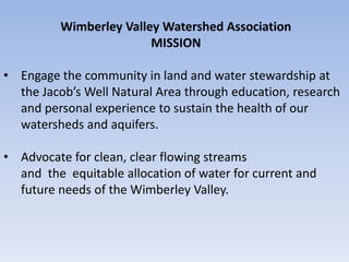
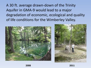
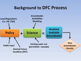
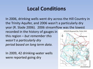
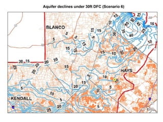
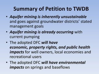
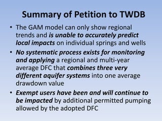
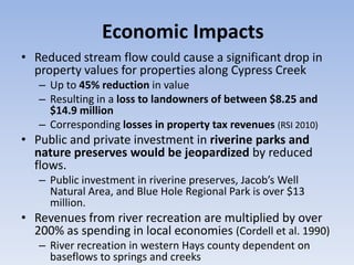
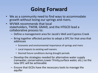
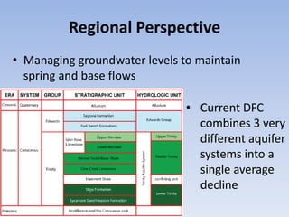
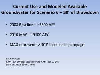
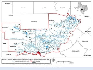
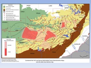
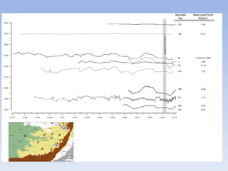
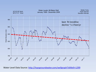
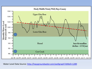
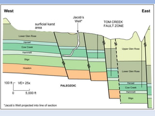
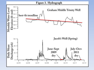
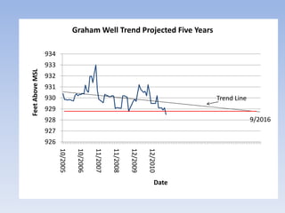
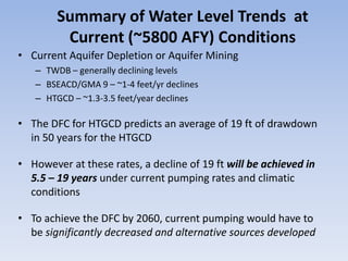
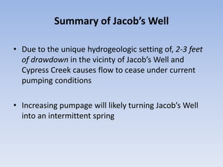
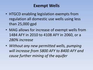
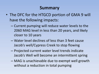
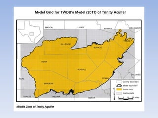
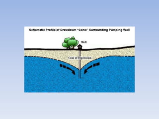
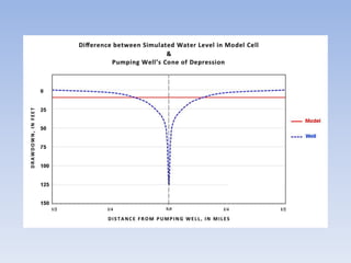
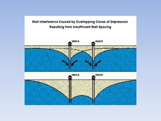
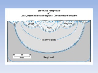
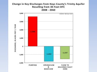
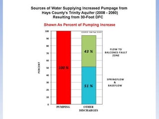
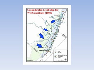
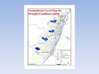
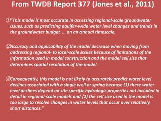
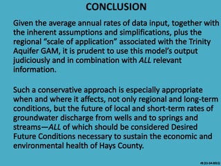
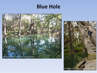
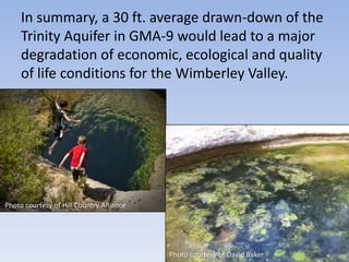
Desired Future Conditions
 Planning for Tomorrow’s
      Water, Today

        November 16th Hearing
           Wimberley, TX
Outline of Today’s Presenters
• Bob Flocke – Mayor, City of Wimberley
• Andy Sansom – Executive Director, Texas State University’s River Systems
  Institute
• David Baker – Executive Director, Wimberley Valley Watershed Association
• John Ashworth – Hydrogeologist, formerly with TWDB
• Doug Wierman – Hydrogeologist, formerly with HTGCD
• Rene Barker – Hydrogeologist, Edwards Aquifer Research & Data Center
• Eric Eskelund – Mayor, City of Woodcreek
• David K. Langford – Kendall County Landowner, retired CEO of the Texas
  Wildlife Association and Hill Country Alliance (HCA) Advisory Board
• Malcolm Harris – Cypress Creek Landowner, Vice President, Wimberley
  Valley Watershed Association
• Steve Klepfer –Executive Director, Friends of Blue Hole, Wimberley
  Business owner and Former Mayor of Wimberley
Bob Flocke
Mayor, City of Wimberley
Andrew Sansom
Executive Director, Texas State University
         River Systems Institute
David Baker
Executive Director, Wimberley Valley
      Watershed Association
WVWA Board of Directors
 Jack Hollon, President
 Malcolm Harris, Vice President
 Pokey Rehmet, Treasurer
 Melinda Gumbert, Secretary
 Dorothy Knight
 Jeff Vasgaard
 DuAnne Redus
Wimberley Valley Watershed Association
                         MISSION

• Engage the community in land and water stewardship at
  the Jacob’s Well Natural Area through education, research
  and personal experience to sustain the health of our
  watersheds and aquifers.

• Advocate for clean, clear flowing streams
  and the equitable allocation of water for current and
  future needs of the Wimberley Valley.
A 30 ft. average drawn-down of the Trinity
Aquifer in GMA-9 would lead to a major
degradation of economic, ecological and quality
of life conditions for the Wimberley Valley.


           2008                      2011
A Desired Future Condition is…

“the
desired, quantified
condition of
groundwater
resources…” (such
as water
levels, water
quality, spring
flows, or volumes)
Background to DFC Process
                               Groundwater
Laws/Regulations                Availability
  (i.e. HB 1763)                 Modeling


                                                 Modeled
    Policy         +      Science          =     Available
                                               Groundwater


                                Existing water use               New
  Public Input                                               Groundwater
                              (permitted + exempt)
            Desired Future                                     Permits
            Condition (DFC)
Public Support for Prudent
          Groundwater Management
• “The most prevalent stakeholder comment received by GMA9 was
  the desire and need to manage the aquifers in such a way as to
  "protect spring flow and base flow to creeks and rivers." This
  sentiment was supported by a diverse group of stakeholders
  including: landowners, state and local government
  representatives, environmental organizations, recreational
  interests, local businesses, and wildlife organizations.
   [http://www.blancocountygroundwater.org/gma9/Background%20Information%20o
   n%20Edwards%20DFC%20Appeal.pdf]

• The second concern most often heard was, in summary, "do not rush
  into setting a DFC, give due consideration to all aspects of the aquifer
  system, and do what is best to provide for sustainable water for those
  who rely on groundwater from GMA 9.”
   [http://www.hillcountryalliance.org/HCA/DecidingFutureCondition]
Local Conditions
In 2006, drinking wells went dry across the Hill Country in
the Trinity Aquifer, and 2006 wasn't a particularly dry
year (R. Slade 2006). 2006 streamflow was the lowest
recorded in the history of gauges in
this region – but remember this
wasn't a particularly dry
period based on long term data.

In 2009, 42 drinking-water wells
were reported going dry
Summary of Petition to TWDB
• Aquifer mining is inherently unsustainable
  and goes against groundwater districts’ stated
  management goals
• Aquifer mining is already occurring with
  current pumping
• The adopted DFC will have
  economic, property rights, and public health
  impacts for well owners, local economies and
  recreational users
• The adopted DFC will have environmental
  impacts on springs and baseflows
Summary of Petition to TWDB
• The GAM model can only show regional
  trends and is unable to accurately predict
  local impacts on individual springs and wells
• No systematic process exists for monitoring
  and applying a regional and multi-year
  average DFC that combines three very
  different aquifer systems into one average
  drawdown value
• Exempt users have been and will continue to
  be impacted by additional permitted pumping
  allowed by the adopted DFC
Economic Impacts
• Reduced stream flow could cause a significant drop in
  property values for properties along Cypress Creek
   – Up to 45% reduction in value
   – Resulting in a loss to landowners of between $8.25 and
     $14.9 million
   – Corresponding losses in property tax revenues (RSI 2010)
• Public and private investment in riverine parks and
  nature preserves would be jeopardized by reduced
  flows.
   – Public investment in riverine preserves, Jacob’s Well
     Natural Area, and Blue Hole Regional Park is over $13
     million.
• Revenues from river recreation are multiplied by over
  200% as spending in local economies (Cordell et al. 1990)
   – River recreation in western Hays county dependent on
     baseflows to springs and creeks
Going Forward
• We as a community need to find ways to accommodate
  growth without losing our springs and rivers.
• WVWA recommends that local
  stakeholders, TWDB, GMA9, and the HTGCD lead a
  collaborative process to:
   – Define a management area for Jacob’s Well and Cypress Creek
   – Bring together affected parties to adopt a DFC for that area that
     addresses
       • Economic and environmental importance of springs and rivers
       • Local impacts to existing well owners
       • Desired future conditions during drought periods
   – Develop the strategies needed for alternative water supply
     (rainwater, conservation,Lower Trinity,surface water, etc.) so the
     new DFC will be achievable
   – Ensure that GCDs have the necessary tools to manage the
     aquifer
John Ashworth
 Hydrogeologist, formerly with
Texas Water Development Board
Regional Perspective
• Managing groundwater levels to maintain
  spring and base flows

                               • Current DFC
                                 combines 3 very
                                 different aquifer
                                 systems into a
                                 single average
                                 decline
Douglas A. Wierman, P.G.
Hydrogeologist, formerly with Hays Trinity
   Groundwater Conservation District
Presentation Topics

• Discussion of regional declines in water levels in the
  Hill County Trinity Aquifer
• Discussion of local Hays County water level
  declines/aquifer mining and impacts on sustainable
  aquifer development
• Quantification of impact of declining water levels on
  flow from Jacob’s Well
• Exempt wells and their impact on sustainable aquifer
  development
Current Use and Modeled Available
Groundwater for Scenario 6 – 30’ of Drawdown

  • 2008 Baseline – ~5800 AFY

  • 2010 MAG - ~9100 AFY

  • MAG represents > 50% increase in pumpage


  Data Sources:
  GAM Task 10-031: Supplement to GAM Task 10-005
  Draft GMA Run 10-050 MAG
GAM Task 10-031: Supplement to GAM Task 10-005 January 25, 2011
Water Level Trend Data Sources
• Texas Water Development Board, Report 379
  Changes in Water Levels in Texas, 1995 to 2005
• BSEACD, Report #2010-0501 Spring 2009
  Potentiometric Map of the Middle Trinity
  Aquifer in Groundwater Management Area
  9, Central Texas
• HTGCD Water Level Monitoring Data
  http://haysgroundwater.com/monitored-
  wells-data
Texas Water Development Board
           Report 379
Changes in Water Levels in Texas,
          1995 to 2005
                   by
            Radu Boghici, P.G.
               July 2011
http://www.twdb.state.tx.us/publications/reports/GroundWaterReports/GWReports/R379_WaterLevels.pdf
SPRING 2009 POTENTIOMETRIC MAP OF THE MIDDLE
TRINITY AQUIFER IN GROUNDWATER MANAGEMENT
             AREA 9, CENTRAL TEXAS
             Brian B. Hunt, P.G., and Brian A. Smith, Ph.D., P.G.,
            Barton Springs/Edwards Aquifer Conservation District


A COLLABORATIVE REPORT WITH:
Ronald G. Fieseler, P.G. Blanco-Pedernales Groundwater Conservation District
Doug Wierman, P.G., and Wesley Schumacher Hays-Trinity Groundwater
   Conservation District
Micah Voulgaris Cow Creek Groundwater Conservation District
George Wissmann Trinity Glen Rose Groundwater Conservation District
Gene Williams Headwaters Groundwater Conservation District
David Jeffery, P.G. Bandera County River Authority & Groundwater District
Paul Tybor, P.G. Hill Country Underground Water Conservation District
David Caldwell Medina County Groundwater Conservation District
Water Level Monitoring Data

Hays Trinity Groundwater Conservation
District Water Level Monitoring Program
Water Levels -Mt Blady Well                       Middle Trinity
                                30º 00' 58'' North                                                     Depth 400 feet
                                98º 07' 01'' West
                                                     January 1999 - December 2009
                                                                                                    Elevation 939 feet


                          880
                                                                                    best fit trendline
                                                                                    decline ~1.3 feet/yr
                          860
  Water Elevation (msl)


                          840


                          820


                          800


                          780


Water Level Data Source: http://haysgroundwater.com/wellgraph?idWell=1299
Water Level Data Source: http://haysgroundwater.com/wellgraph?idWell=1289
Impact of Water Declines on the Flow
          from Jacob’s Well
Graham Well Trend Projected Five Years

                 934
                 933
Feet Above MSL


                 932
                 931
                 930                                                                  Trend Line
                 929
                 928                                                                               9/2016
                 927
                 926
                       10/2005

                                  10/2006

                                            11/2007

                                                      11/2008

                                                                12/2009

                                                                          12/2010


                                                                               Date
Summary of Water Level Trends at
         Current (~5800 AFY) Conditions
• Current Aquifer Depletion or Aquifer Mining
   – TWDB – generally declining levels
   – BSEACD/GMA 9 – ~1-4 feet/yr declines
   – HTGCD – ~1.3-3.5 feet/year declines

• The DFC for HTGCD predicts an average of 19 ft of drawdown
  in 50 years for the HTGCD

• However at these rates, a decline of 19 ft will be achieved in
  5.5 – 19 years under current pumping rates and climatic
  conditions

• To achieve the DFC by 2060, current pumping would have to
  be significantly decreased and alternative sources developed
Summary of Jacob’s Well

• Due to the unique hydrogeologic setting of, 2-3 feet
  of drawdown in the vicinty of Jacob’s Well and
  Cypress Creek causes flow to cease under current
  pumping conditions

• Increasing pumpage will likely turning Jacob’s Well
  into an intermittent spring
Exempt Wells
• HTGCD enabling legislation exempts from
  regulation all domestic use wells using less
  than 25,000 gpd
• MAG allows for increase of exempt wells from
  1484 AFY in 2010 to 4108 AFY in 2060, or a
  280% increase
• Without any new permitted wells, pumping
  will increase from 5800 AFY to 8400 AFY and
  cause further mining of the aquifer
Summary
• The DFC for the HTGCD portion of GMA 9 will
  have the following impacts:
  – Current pumping will reduce water levels to the
    2060 MAG level in less than 20 years, and likely
    closer to 10 years
  – Water level declines of less than 3 feet cause
    Jacob’s well/Cypress Creek to stop flowing
  – Projected current water level trends indicate
    Jacob’s Well will become an intermittent spring
  – MAG is unachievable due to exempt well growth
    without a reduction in total pumping
Rene A. Barker, P.G.
Hydrogeologist, Edwards Aquifer
    Research & Data Center
PRESENTATION TOPICS


– Regional & Average Annual Versus Local & Short Term
– Model’s “Scale of Application”
– Effects of 30-DFC on Surface Water & Edwards Aquifer
From TWDB Report 377 (Jones et al., 2011)
①“This model is most accurate in assessing regional-scale groundwater
  issues, such as predicting aquifer-wide water level changes and trends in
  the groundwater budget … on an annual timescale.

②Accuracy and applicability of the model decrease when moving from
  addressing regional- to local-scale issues because of limitations of the
  information used in model construction and the model cell size that
  determines spatial resolution of the model.

③Consequently, this model is not likely to accurately predict water level
  declines associated with a single well or spring because (1) these water
  level declines depend on site specific hydrologic properties not included in
  detail in regional-scale models and (2) the cell size used in the model is
  too large to resolve changes in water levels that occur over relatively
  short distances.”
CONCLUSION
Eric Eskelund
Mayor, City of Woodcreek
David K. Langford
      Kendall County Landowner,
    Retired CEO of the Texas Wildlife
Association and Hill Country Alliance (HCA)
              Advisory Board
Malcolm Harris
  Vice President, Wimberley Valley
Watershed Association and Landowner
Photo courtesy of David Baker

                                Photo courtesy of David Baker
Steve Klepfer
 Executive Director, Friends of
Blue Hole and Business Owner
Blue Hole


Photo courtesy of Cypress Creek Project


                                                      Courtesy of Austin-American Statesman
Summary of Petition to TWDB
• Aquifer mining is inherently unsustainable
  and goes against groundwater districts’ stated
  management goals
• Aquifer mining is already occurring with
  current pumping
• The adopted DFC will have
  economic, property rights, and public health
  impacts for well owners, local economies and
  recreational users
• The adopted DFC will have environmental
  impacts on springs and baseflows
Summary of Petition to TWDB
• The GAM model can only show regional
  trends and is unable to accurately predict
  local impacts on individual springs and wells
• No systematic process exists for monitoring
  and applying a regional and multi-year
  average DFC that combines three very
  different aquifer systems into one average
  drawdown value
• Exempt users have been and will continue to
  be impacted by additional permitted pumping
  allowed by the adopted DFC
In summary, a 30 ft. average drawn-down of the
     Trinity Aquifer in GMA-9 would lead to a major
     degradation of economic, ecological and quality
     of life conditions for the Wimberley Valley.


Photo courtesy of Hill Country Alliance


                                          Photo courtesy of David Baker
Summary & Conclusions
• We must find a way to accommodate growth while maintaining
  baseflows to springs and rivers.
• Recommend we begin a collaborative process that will
    – Define a special management area for Jacob’s Well and Cypress Creek
    – Bring together affected parties to adopt a DFC for this area that
      addresses economic and environmental importance of springs and
      rivers
• Create a DFC that specifically addresses:
    – Local impacts to existing well owners
    – Drought conditions
    – Springs and baseflows
• Develop the strategies needed for alternative water supply
  (rainwater, conservation, Lower Trinity, surface water, etc.) so the
  new DFC will be achievable
• Ensure GCD’s have the necessary tools to manage the aquifer
We do not inherit the earth from our ancestors,
       we borrow it from our children.
               ~Native American Proverb

Wimberley Valley Watershed Association DFC Petition ppt. 11.16.2011

  • 1.
    Desired Future Conditions Planning for Tomorrow’s Water, Today November 16th Hearing Wimberley, TX
  • 2.
    Outline of Today’sPresenters • Bob Flocke – Mayor, City of Wimberley • Andy Sansom – Executive Director, Texas State University’s River Systems Institute • David Baker – Executive Director, Wimberley Valley Watershed Association • John Ashworth – Hydrogeologist, formerly with TWDB • Doug Wierman – Hydrogeologist, formerly with HTGCD • Rene Barker – Hydrogeologist, Edwards Aquifer Research & Data Center • Eric Eskelund – Mayor, City of Woodcreek • David K. Langford – Kendall County Landowner, retired CEO of the Texas Wildlife Association and Hill Country Alliance (HCA) Advisory Board • Malcolm Harris – Cypress Creek Landowner, Vice President, Wimberley Valley Watershed Association • Steve Klepfer –Executive Director, Friends of Blue Hole, Wimberley Business owner and Former Mayor of Wimberley
  • 3.
  • 4.
    Andrew Sansom Executive Director,Texas State University River Systems Institute
  • 5.
    David Baker Executive Director,Wimberley Valley Watershed Association
  • 6.
    WVWA Board ofDirectors Jack Hollon, President Malcolm Harris, Vice President Pokey Rehmet, Treasurer Melinda Gumbert, Secretary Dorothy Knight Jeff Vasgaard DuAnne Redus
  • 7.
    Wimberley Valley WatershedAssociation MISSION • Engage the community in land and water stewardship at the Jacob’s Well Natural Area through education, research and personal experience to sustain the health of our watersheds and aquifers. • Advocate for clean, clear flowing streams and the equitable allocation of water for current and future needs of the Wimberley Valley.
  • 8.
    A 30 ft.average drawn-down of the Trinity Aquifer in GMA-9 would lead to a major degradation of economic, ecological and quality of life conditions for the Wimberley Valley. 2008 2011
  • 10.
    A Desired FutureCondition is… “the desired, quantified condition of groundwater resources…” (such as water levels, water quality, spring flows, or volumes)
  • 11.
    Background to DFCProcess Groundwater Laws/Regulations Availability (i.e. HB 1763) Modeling Modeled Policy + Science = Available Groundwater Existing water use New Public Input Groundwater (permitted + exempt) Desired Future Permits Condition (DFC)
  • 12.
    Public Support forPrudent Groundwater Management • “The most prevalent stakeholder comment received by GMA9 was the desire and need to manage the aquifers in such a way as to "protect spring flow and base flow to creeks and rivers." This sentiment was supported by a diverse group of stakeholders including: landowners, state and local government representatives, environmental organizations, recreational interests, local businesses, and wildlife organizations. [http://www.blancocountygroundwater.org/gma9/Background%20Information%20o n%20Edwards%20DFC%20Appeal.pdf] • The second concern most often heard was, in summary, "do not rush into setting a DFC, give due consideration to all aspects of the aquifer system, and do what is best to provide for sustainable water for those who rely on groundwater from GMA 9.” [http://www.hillcountryalliance.org/HCA/DecidingFutureCondition]
  • 13.
    Local Conditions In 2006,drinking wells went dry across the Hill Country in the Trinity Aquifer, and 2006 wasn't a particularly dry year (R. Slade 2006). 2006 streamflow was the lowest recorded in the history of gauges in this region – but remember this wasn't a particularly dry period based on long term data. In 2009, 42 drinking-water wells were reported going dry
  • 15.
    Summary of Petitionto TWDB • Aquifer mining is inherently unsustainable and goes against groundwater districts’ stated management goals • Aquifer mining is already occurring with current pumping • The adopted DFC will have economic, property rights, and public health impacts for well owners, local economies and recreational users • The adopted DFC will have environmental impacts on springs and baseflows
  • 16.
    Summary of Petitionto TWDB • The GAM model can only show regional trends and is unable to accurately predict local impacts on individual springs and wells • No systematic process exists for monitoring and applying a regional and multi-year average DFC that combines three very different aquifer systems into one average drawdown value • Exempt users have been and will continue to be impacted by additional permitted pumping allowed by the adopted DFC
  • 17.
    Economic Impacts • Reducedstream flow could cause a significant drop in property values for properties along Cypress Creek – Up to 45% reduction in value – Resulting in a loss to landowners of between $8.25 and $14.9 million – Corresponding losses in property tax revenues (RSI 2010) • Public and private investment in riverine parks and nature preserves would be jeopardized by reduced flows. – Public investment in riverine preserves, Jacob’s Well Natural Area, and Blue Hole Regional Park is over $13 million. • Revenues from river recreation are multiplied by over 200% as spending in local economies (Cordell et al. 1990) – River recreation in western Hays county dependent on baseflows to springs and creeks
  • 18.
    Going Forward • Weas a community need to find ways to accommodate growth without losing our springs and rivers. • WVWA recommends that local stakeholders, TWDB, GMA9, and the HTGCD lead a collaborative process to: – Define a management area for Jacob’s Well and Cypress Creek – Bring together affected parties to adopt a DFC for that area that addresses • Economic and environmental importance of springs and rivers • Local impacts to existing well owners • Desired future conditions during drought periods – Develop the strategies needed for alternative water supply (rainwater, conservation,Lower Trinity,surface water, etc.) so the new DFC will be achievable – Ensure that GCDs have the necessary tools to manage the aquifer
  • 19.
    John Ashworth Hydrogeologist,formerly with Texas Water Development Board
  • 20.
    Regional Perspective • Managinggroundwater levels to maintain spring and base flows • Current DFC combines 3 very different aquifer systems into a single average decline
  • 21.
    Douglas A. Wierman,P.G. Hydrogeologist, formerly with Hays Trinity Groundwater Conservation District
  • 22.
    Presentation Topics • Discussionof regional declines in water levels in the Hill County Trinity Aquifer • Discussion of local Hays County water level declines/aquifer mining and impacts on sustainable aquifer development • Quantification of impact of declining water levels on flow from Jacob’s Well • Exempt wells and their impact on sustainable aquifer development
  • 23.
    Current Use andModeled Available Groundwater for Scenario 6 – 30’ of Drawdown • 2008 Baseline – ~5800 AFY • 2010 MAG - ~9100 AFY • MAG represents > 50% increase in pumpage Data Sources: GAM Task 10-031: Supplement to GAM Task 10-005 Draft GMA Run 10-050 MAG
  • 24.
    GAM Task 10-031:Supplement to GAM Task 10-005 January 25, 2011
  • 25.
    Water Level TrendData Sources • Texas Water Development Board, Report 379 Changes in Water Levels in Texas, 1995 to 2005 • BSEACD, Report #2010-0501 Spring 2009 Potentiometric Map of the Middle Trinity Aquifer in Groundwater Management Area 9, Central Texas • HTGCD Water Level Monitoring Data http://haysgroundwater.com/monitored- wells-data
  • 26.
    Texas Water DevelopmentBoard Report 379 Changes in Water Levels in Texas, 1995 to 2005 by Radu Boghici, P.G. July 2011
  • 27.
  • 28.
    SPRING 2009 POTENTIOMETRICMAP OF THE MIDDLE TRINITY AQUIFER IN GROUNDWATER MANAGEMENT AREA 9, CENTRAL TEXAS Brian B. Hunt, P.G., and Brian A. Smith, Ph.D., P.G., Barton Springs/Edwards Aquifer Conservation District A COLLABORATIVE REPORT WITH: Ronald G. Fieseler, P.G. Blanco-Pedernales Groundwater Conservation District Doug Wierman, P.G., and Wesley Schumacher Hays-Trinity Groundwater Conservation District Micah Voulgaris Cow Creek Groundwater Conservation District George Wissmann Trinity Glen Rose Groundwater Conservation District Gene Williams Headwaters Groundwater Conservation District David Jeffery, P.G. Bandera County River Authority & Groundwater District Paul Tybor, P.G. Hill Country Underground Water Conservation District David Caldwell Medina County Groundwater Conservation District
  • 31.
    Water Level MonitoringData Hays Trinity Groundwater Conservation District Water Level Monitoring Program
  • 32.
    Water Levels -MtBlady Well Middle Trinity 30º 00' 58'' North Depth 400 feet 98º 07' 01'' West January 1999 - December 2009 Elevation 939 feet 880 best fit trendline decline ~1.3 feet/yr 860 Water Elevation (msl) 840 820 800 780 Water Level Data Source: http://haysgroundwater.com/wellgraph?idWell=1299
  • 33.
    Water Level DataSource: http://haysgroundwater.com/wellgraph?idWell=1289
  • 34.
    Impact of WaterDeclines on the Flow from Jacob’s Well
  • 37.
    Graham Well TrendProjected Five Years 934 933 Feet Above MSL 932 931 930 Trend Line 929 928 9/2016 927 926 10/2005 10/2006 11/2007 11/2008 12/2009 12/2010 Date
  • 38.
    Summary of WaterLevel Trends at Current (~5800 AFY) Conditions • Current Aquifer Depletion or Aquifer Mining – TWDB – generally declining levels – BSEACD/GMA 9 – ~1-4 feet/yr declines – HTGCD – ~1.3-3.5 feet/year declines • The DFC for HTGCD predicts an average of 19 ft of drawdown in 50 years for the HTGCD • However at these rates, a decline of 19 ft will be achieved in 5.5 – 19 years under current pumping rates and climatic conditions • To achieve the DFC by 2060, current pumping would have to be significantly decreased and alternative sources developed
  • 39.
    Summary of Jacob’sWell • Due to the unique hydrogeologic setting of, 2-3 feet of drawdown in the vicinty of Jacob’s Well and Cypress Creek causes flow to cease under current pumping conditions • Increasing pumpage will likely turning Jacob’s Well into an intermittent spring
  • 40.
    Exempt Wells • HTGCDenabling legislation exempts from regulation all domestic use wells using less than 25,000 gpd • MAG allows for increase of exempt wells from 1484 AFY in 2010 to 4108 AFY in 2060, or a 280% increase • Without any new permitted wells, pumping will increase from 5800 AFY to 8400 AFY and cause further mining of the aquifer
  • 41.
    Summary • The DFCfor the HTGCD portion of GMA 9 will have the following impacts: – Current pumping will reduce water levels to the 2060 MAG level in less than 20 years, and likely closer to 10 years – Water level declines of less than 3 feet cause Jacob’s well/Cypress Creek to stop flowing – Projected current water level trends indicate Jacob’s Well will become an intermittent spring – MAG is unachievable due to exempt well growth without a reduction in total pumping
  • 42.
    Rene A. Barker,P.G. Hydrogeologist, Edwards Aquifer Research & Data Center
  • 43.
    PRESENTATION TOPICS – Regional& Average Annual Versus Local & Short Term – Model’s “Scale of Application” – Effects of 30-DFC on Surface Water & Edwards Aquifer
  • 61.
    From TWDB Report377 (Jones et al., 2011) ①“This model is most accurate in assessing regional-scale groundwater issues, such as predicting aquifer-wide water level changes and trends in the groundwater budget … on an annual timescale. ②Accuracy and applicability of the model decrease when moving from addressing regional- to local-scale issues because of limitations of the information used in model construction and the model cell size that determines spatial resolution of the model. ③Consequently, this model is not likely to accurately predict water level declines associated with a single well or spring because (1) these water level declines depend on site specific hydrologic properties not included in detail in regional-scale models and (2) the cell size used in the model is too large to resolve changes in water levels that occur over relatively short distances.”
  • 62.
  • 64.
  • 65.
    David K. Langford Kendall County Landowner, Retired CEO of the Texas Wildlife Association and Hill Country Alliance (HCA) Advisory Board
  • 67.
    Malcolm Harris Vice President, Wimberley Valley Watershed Association and Landowner
  • 68.
    Photo courtesy ofDavid Baker Photo courtesy of David Baker
  • 69.
    Steve Klepfer ExecutiveDirector, Friends of Blue Hole and Business Owner
  • 70.
    Blue Hole Photo courtesyof Cypress Creek Project Courtesy of Austin-American Statesman
  • 71.
    Summary of Petitionto TWDB • Aquifer mining is inherently unsustainable and goes against groundwater districts’ stated management goals • Aquifer mining is already occurring with current pumping • The adopted DFC will have economic, property rights, and public health impacts for well owners, local economies and recreational users • The adopted DFC will have environmental impacts on springs and baseflows
  • 72.
    Summary of Petitionto TWDB • The GAM model can only show regional trends and is unable to accurately predict local impacts on individual springs and wells • No systematic process exists for monitoring and applying a regional and multi-year average DFC that combines three very different aquifer systems into one average drawdown value • Exempt users have been and will continue to be impacted by additional permitted pumping allowed by the adopted DFC
  • 73.
    In summary, a30 ft. average drawn-down of the Trinity Aquifer in GMA-9 would lead to a major degradation of economic, ecological and quality of life conditions for the Wimberley Valley. Photo courtesy of Hill Country Alliance Photo courtesy of David Baker
  • 74.
    Summary & Conclusions •We must find a way to accommodate growth while maintaining baseflows to springs and rivers. • Recommend we begin a collaborative process that will – Define a special management area for Jacob’s Well and Cypress Creek – Bring together affected parties to adopt a DFC for this area that addresses economic and environmental importance of springs and rivers • Create a DFC that specifically addresses: – Local impacts to existing well owners – Drought conditions – Springs and baseflows • Develop the strategies needed for alternative water supply (rainwater, conservation, Lower Trinity, surface water, etc.) so the new DFC will be achievable • Ensure GCD’s have the necessary tools to manage the aquifer
  • 75.
    We do notinherit the earth from our ancestors, we borrow it from our children. ~Native American Proverb

Editor's Notes

  • #12 The DFC process is the first time in groundwater planning in Texas  that stakeholders have been asked across an entire aquifer system what they want the future of their aquifer to look like.A lot more goes into both the Policy and Science boxes than what is shown here, it is a very complex process.To summarize:Regional planning meetings (9 total) have taken place of groundwater districts, with research and discussion to answer what scenarios are Achievable, Acceptable, Desirable, and ReasonableTWDB, primarily through the use of groundwater models, helps regions determine maximum amount of water which can be pumped and still achieve a DFC -- this volume of water is known as the Modeled Available Groundwater, or MAG. With public input, individual local GCDs then develop management policies to permit groundwater withdrawal up to the MAG.
  • #15 30 ft average overall, but this map shows how the drawdowns in certain areas will be much higher (Rene will elaborate)91% of platted lots are 10 acres or less90% of lots in western Hays County are still undeveloped
  • #16 AQUIFER MINING IS INHERENTLY UNSUSTAINABLE “Drawdown” is not the issue. The problem is long-term water level DECLINE—indicative of permanent dewatering of the Trinity Aquifer. One of the earliest threats to sustainable yield is groundwater mining, as indicated by long-term water-level decline. A continuation of unabated extraction of groundwater from Trinity Aquifer storage will eventually deplete the aquifer to the extent it is incapable of supplying water in any reasonable economical or physical sense. i.e. there will be no recovering groundwater levels from a permanent decline.AQUIFER MINING IS OCCURRING UNDER CURRENT PUMPING Aquifer level declines of up to 150 feet have been recorded in western Hays and Blanco Counties from 1975 to 2009. Rates of decline are estimated between 1 and 3.5 feet per year. At these rates, an average 19 ft of drawdown (projected in 50 years with >50% increase in pumping) will actually be achieved in 5.5 – 19 years under current pumping rates and climatic conditions.The effects of historical and current rates of pumping have already tapped the threshold of what most scientific literature considers aquifer dewatering or groundwater mining—in other words: unsustainable development. TWDB’s GAM results indicate that the 30-foot DFC will only exacerbate existing problems. In addition to the expense of having to deepen wells and pump water from deeper depths, such problems include the likelihood of wells, springs, and baseflow drying up—conditions observed during recent (post-1987) droughts that were caused by events far less severe than several droughts known to have occurred before 1960.IMPACTS ON WELL OWNERS/PROPERTY RIGHTS HOLDERS The GAM model underestimates the actual, site-specific drawdown that results from the pumping of individual wells within the actual aquifer. Therefore, in heavily pumped areas, it is likely that individual wells and springs will pump dry or cease flowing under conditions far less severe than those simulated for the same area. For this reason, it is highly likely that the adopted regional DFC will negatively affect the reliability of private wells with locally impacted groundwater levels. The fact that it is impossible for anyone or any agency to predict with any degree of assurance the actual number, location, and longevity of these dried up wells and springs makes the 30-foot DFC inconsistent with sound water-resource management, given the sheer number of environmental and economic concerns and unknowns it creates.Dry drinking wells and groundwater declines are a public health and safety threat The drying up of springs and rivers also jeopardizes the substantial public and private investment in riverine property parks and nature preserves such as Blue Hole Regional Park and Jacob’s Well Natural Area. A dry creek would reduce property values by 25%-45%.
  • #17 COARSE RESOLUTION OF MODEL/IT IS INAPPROPRIATE TO USE A REGIONAL AVERAGE GOAL TO DICTATE LOCAL POLICYthe TWDB modelers characterize the GAM model’s use as limited to a “regional scale of application.” In other words, the simulated conditions used to formulate the 30-foot DFC are not necessarily consistent with desired local and short-term conditions. Although the Hill Country GAM is calibrated to reproduce observed historical conditions, this fact alone does not insure that the model is verified—in other words: capable of projecting future water level, springflow and water-budget conditions within an appropriate degree of expectation.It appears unwise and inconsistent within the concept of sustainable groundwater development to use such large-scale model output to justify pumping increases that are simulated to cause an additional 30 feet of regionalized, average-annual rates of water-level decline.We need to determine how the effects of groundwater development can be most effectively monitored, analyzed, and controlled to maximize the efficiency of future water production
  • #72 AQUIFER MINING IS INHERENTLY UNSUSTAINABLE “Drawdown” is not the issue. The problem is long-term water level DECLINE—indicative of permanent dewatering of the Trinity Aquifer. One of the earliest threats to sustainable yield is groundwater mining, as indicated by long-term water-level decline. A continuation of unabated extraction of groundwater from Trinity Aquifer storage will eventually deplete the aquifer to the extent it is incapable of supplying water in any reasonable economical or physical sense. i.e. there will be no recovering groundwater levels from a permanent decline.AQUIFER MINING IS OCCURRING UNDER CURRENT PUMPING Aquifer level declines of up to 150 feet have been recorded in western Hays and Blanco Counties from 1975 to 2009. Rates of decline are estimated between 1 and 3.5 feet per year. At these rates, an average 19 ft of drawdown (projected in 50 years with >50% increase in pumping) will actually be achieved in 5.5 – 19 years under current pumping rates and climatic conditions.The effects of historical and current rates of pumping have already tapped the threshold of what most scientific literature considers aquifer dewatering or groundwater mining—in other words: unsustainable development. TWDB’s GAM results indicate that the 30-foot DFC will only exacerbate existing problems. In addition to the expense of having to deepen wells and pump water from deeper depths, such problems include the likelihood of wells, springs, and baseflow drying up—conditions observed during recent (post-1987) droughts that were caused by events far less severe than several droughts known to have occurred before 1960.IMPACTS ON WELL OWNERS/PROPERTY RIGHTS HOLDERS The GAM model underestimates the actual, site-specific drawdown that results from the pumping of individual wells within the actual aquifer. Therefore, in heavily pumped areas, it is likely that individual wells and springs will pump dry or cease flowing under conditions far less severe than those simulated for the same area. For this reason, it is highly likely that the adopted regional DFC will negatively affect the reliability of private wells with locally impacted groundwater levels. The fact that it is impossible for anyone or any agency to predict with any degree of assurance the actual number, location, and longevity of these dried up wells and springs makes the 30-foot DFC inconsistent with sound water-resource management, given the sheer number of environmental and economic concerns and unknowns it creates.Dry drinking wells and groundwater declines are a public health and safety threat The drying up of springs and rivers also jeopardizes the substantial public and private investment in riverine property parks and nature preserves such as Blue Hole Regional Park and Jacob’s Well Natural Area. A dry creek would reduce property values by 25%-45%.
  • #73 COARSE RESOLUTION OF MODEL/IT IS INAPPROPRIATE TO USE A REGIONAL AVERAGE GOAL TO DICTATE LOCAL POLICYthe TWDB modelers characterize the GAM model’s use as limited to a “regional scale of application.” In other words, the simulated conditions used to formulate the 30-foot DFC are not necessarily consistent with desired local and short-term conditions. Although the Hill Country GAM is calibrated to reproduce observed historical conditions, this fact alone does not insure that the model is verified—in other words: capable of projecting future water level, springflow and water-budget conditions within an appropriate degree of expectation.It appears unwise and inconsistent within the concept of sustainable groundwater development to use such large-scale model output to justify pumping increases that are simulated to cause an additional 30 feet of regionalized, average-annual rates of water-level decline.We need to determine how the effects of groundwater development can be most effectively monitored, analyzed, and controlled to maximize the efficiency of future water production