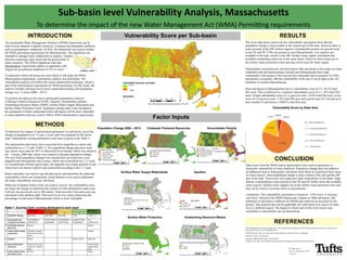
This document summarizes a vulnerability analysis of sub-basins in Massachusetts to determine which are most likely to experience water stress under new regulations. The analysis scored sub-basins based on 7 factors like population change, groundwater permits, and surface water resources. It found the eastern and southwest parts of the state most vulnerable due to high population growth. Over 76% of the state's area had medium vulnerability. The analysis can help identify which sub-basins may need to implement strategies to minimize water use under the new Water Management Act.
CaBALondon 08 Di Hammond, Affinity WaterCaBASupport
Details of Affinity Water's partnership working with volunteers to monitor baseline and hydro-ecological response to abstraction and river restoration.
CaBALondon 08 Di Hammond, Affinity WaterCaBASupport
Details of Affinity Water's partnership working with volunteers to monitor baseline and hydro-ecological response to abstraction and river restoration.
Kevin Carter
The Environmental Protection Agency (EPA) has announced its intent to adopt numeric nutrient criteria for Florida’s water bodies (lakes, streams, canals and estuaries). The criterion is
unprecedented in the nation and has drawn national attention to Florida’s water quality programs. The panel will discuss the
legal genesis of this proposed rule, including the most up to date developments in the state legislature and Congress; its technical
aspects, including the scientific basis for the rule; implementation and relief mechanisms; and the criteria’s impact on Florida’s current permitting programs, as well as its impact on a wide variety of stakeholders in Florida.
Analysis and Characterization of Kainji Reservoir Inflow System_ Crimson Publ...CrimsonpublishersEAES
Analysis and Characterization of Kainji Reservoir Inflow System by Mohammed J Mamman*, Otache Y Matins and Jibril Ibrahim in Environmental Analysis & Ecology Studies
II WORKSHOP INTERNACIONAL: GESTÃO SUSTENTÁVEL DE RECURSOS HÍDRICOS NA AGRICULTURA IRRIGADA:
Pesquisa, Políticas Públicas, Extensão Rural e Participação dos Agricultores do Nebraska, USA e do Oeste da Bahia, Brasil
AUDITÓRIO AIBA - BARREIRAS, BA
Presented by Birhanu Zemadim (IWMI) and Emily Schmidt (IFPRI) at the Nile Basin Development Challenge (NBDC) Science Workshop, Addis Ababa, Ethiopia, 9–10 July 2013
Best Fit and Selection of Probability Distribution Models for Frequency Analy...IJERD Editor
Frequency analysis of extreme low mean annual rainfall events is important to water resource planners at catchment level because mean annual rainfall is an important parameter in determining mean annual runoff. Mean annual runoff is an important input in determining surface water available for water resource infrastructure development. In order to carry out frequency analysis of extreme low mean annual rainfall events, it is necessary to identify the best fit probability distribution models (PDMs) for the frequency analysis. The primary objective of the study was to develop two model identification criteria. The first criterion was developed to identify candidate probability distribution models from which the best fit probability distribution models were identified. The second criterion was applied to select the best fit probability distribution models from the candidate models. The secondary objectives were:
Caroline Plouff Top Ten Water Conservation Tips for FarmersCaroline Plouff
Agriculture uses an estimated 70% of the freshwater withdrawals globally and 40% of freshwater withdrawals in the United States. With severe droughts, shrinking reservoirs, and freshwater shortages in some areas of the US, water conservation is as important as ever for farmers.
If you have another farm water conservation tip, please share it below in the comments.
A GIS-Based Framework to Identify Opportunities to Use Surface Water to Offse...ASADULISLAMSORIF
The state of Louisiana (Fig. 1) is
characterized by a humid subtropical
climate and receives about 150 cm of
rain per year.
Louisiana hosts about 40% of the
freshwater wetlands in the U.S. is a hub
for the petroleum industry and the third
leading producer of rice in the U.S. Louisiana is also a leading exporter of
aquaculture products
Water quality modeling of an agricultural watershed with best management prac...eSAT Publishing House
IJRET : International Journal of Research in Engineering and Technology is an international peer reviewed, online journal published by eSAT Publishing House for the enhancement of research in various disciplines of Engineering and Technology. The aim and scope of the journal is to provide an academic medium and an important reference for the advancement and dissemination of research results that support high-level learning, teaching and research in the fields of Engineering and Technology. We bring together Scientists, Academician, Field Engineers, Scholars and Students of related fields of Engineering and Technology
Water quality modeling of an agricultural watershed with best management prac...eSAT Journals
Abstract Simulation of Best Management Practices (BMPs) affecting water quality is necessary while modeling the water quality of agricultural watersheds with BMPs in place to mitigate pollution of river. Previous studies explored methods to represent some of the water quality BMPs. However, there are still gaps in the research to represent some other BMPs such as constructed wetlands, wastewater reuse, residue management and nutrient management. This paper focuses on modeling of BMPs affecting water quality. The study area is a 1692 Km2 cultivated watershed in South Texas, USA where water quality is impaired for dissolved oxygen (DO). The water quality constituents analyzed for the study are sediment, nitrogen, phosphorus, water temperature and dissolved oxygen. Apart from identification of methodology to simulate BMPs, this study estimated extent of pollution mitigation by each type of BMP. Binomial method of water quality analysis was used to judge the compliance of river reach for meeting DO criterion. This manuscript will discuss modeling of water quality constituents and the BMPs that affect water quality. In addition, the estimation of dissolved oxygen compliance of the watershed is also discussed. The results from the study indicate that the agricultural BMPs implemented in the watershed and establishment of stringer water quality criteria have in fact improved the DO trends in the tidal section of the river, which did not meet the stipulated DO criterion before. Index Terms: Arroyo, BMP, dissolved oxygen, residue management, nutrient management, water quality
Geospatial Condition Analysis: A new tool to assess the condition of northeast terrestrial and aquatic habitats
Mark Anderson, Melissa Clark, Charles Ferree, Alexandra Jospe, and Arlene Olivero Sheldon
The Nature Conservancy
We created a GIS tool to assess the condition of 116 terrestrial and aquatic habitats in the Northeast at state and regional scales. The tool is based on the newly released Northeast Terrestrial Habitat Map and the Northeast Aquatic Habitat Classification and their accompanying datasets. It allows each habitat to be evaluated across its entire range in the region or within a single state for condition factors such as predicted loss to development, securement from development, forest stand age, habitat patch size, amount of core area and others. For aquatic systems, users can summarize the number of dams, length of connected network, impervious surfaces in the watershed and other factors. The talk will illustrate how the tool works and summarize some of the findings for the fourteen ecological condition metrics, and comparative results of the metric as applied to the terrestrial and aquatic habitats across the region.
Presented by Charlotte MacAlister, Birhanu Zemadim, Teklu Erkossa, Amare Haileslassie, Dan Fuka, Tammo Steenhuis, Solomon Seyoum, Holger Hoff, Kinde Getnet, and Nancy Johnson to the Nile Basin Development ChallengeScience and Reflection Workshop, Addis Ababa, 4-6 May 2011
1. Sub-basin level Vulnerability Analysis, Massachusetts
To determine the impact of the new Water Management Act (WMA) Permitting requirements
INTRODUCTION RESULTS
CONCLUSION
METHODS
Surface Water Supply Watersheds
Coldwater Fisheries Resources Groundwater PermitsPopulation Change 2000 – 2013
Aquifers
Surface Water Protection Outstanding Resource Waters
Table 1. Scoring Card: scoring attributed to each layer
The seven data layers used to do the vulnerability assessment show that the
population change is most evident in the eastern part of the state. However there is
some increase in the SW (yellow regions). Groundwater permits are present most
in the NE and SE. CFRs are present in west Massachusetts. Few aquifers are
available in the state, mostly in the SW. Surface water supply watersheds and
available outstanding waters are in the same basins. However those baisns are in
the surface water protection zones and may not be used for water supply.
Vulnerability assessment per sub-basin shows that sub-basins in the center are least
vulnerable and sub-basins present towards east Massachusetts have high
vulnerability. Sub-basins in the west are also vulnerable due to presence of CFRs
and absence of aquifers. But the vulnerability in the east is not as high as the vul-
nerability in western Massachusetts.
Most sub-basins in Massachusetts have a vulnerability score of 2 (~76.2% total
MA area). This is followed by a medium vulnerability score of 3 (~18% total MA
area). A high vulnerability score of 1 is given to only ~4.05% total MA area. A low
score of 4 is given to only ~1.8% total MA area and a good score of 5 was given to
least number of sub-basins (~0.003% total MA area).
Vulnerability Score by State Area
The Sustainable Water Management Initiative (SWMI) framework can be
used to asses impacts to aquatic resources, to natural and manmade conditions
such as groundwater withdrawal. In 2012, the framework was used to outline
the WMA permitting requirements for Massachusetts. The regulations are
intended to manage water withdrawals to ensure a balance
between competing water needs and the preservation of
water resources. The WMA regulations state that
Minimization requirements applies to applicants with
August net groundwater depletion of 25% or more4
.
To determine which sub-basins are most likely to fall under the WMA
Minimization requirement, vulnerability analysis was performed. The
vulnerability analysis will follow the source optimization technique, which is
part of the minimization requirement for WMA permitting. For this study, the
analysis includes sub-basin level source optimization along with population
change over 13 years (2000—2013).
To perform the analysis the source optimization parameters used are:
Coldwater Fisheries Resources (CFR), Aquifers, Groundwater permits,
Outstanding Resource Waters (ORW), Surface Water Supply Watersheds and
Surface Water Protection Zones. Population change data is also included to
the parameters to better understand which sub-basins will be most vulnerable
to water depletion and may need to follow WMA minimization requirements.
To determine the impact of optimization parameters on sub-basins, given the
change in population over 13 year, a score card was prepared for the layers
used. Vulnerability scoring attributed to each layer is given in the Table 1.
The optimization data layers were converted from shapefiles to rasters and
reclassified on a 1-5 scale (Table 1). The population change data layer used
was census tracts data for 2013 in Microsoft Excel format, which was joined to
the Census_2000 data. Query was created to calculate population change.
The new field (population change) was selected and converted into a new
shapefile and subsequently into a raster, which was reclassified on a 1-5 scale.
For Groundwater Permits (point data), the shapefile was joined spatially to sub
-basin layer for density analysis and reclassified according to the 1-5 scale.
Raster calculator was used to sum the data layers and determine the statewide
vulnerability which was reclassified. Zonal Statistics were used to determine
the mean vulnerability score per sub-basin.
Math tool in Spatial Analyst tools was used to convert the vulnerability score
per basin into integer to determine the number of cells attributed to each score.
Cell size was previously set to 300 meters. Total area (km2
) for each score was
calculated in the attribute table. Microsoft Excel was used to determine the
percentage of total area in Massachusetts which is most vulnerable.
Bad Score Good Score
1 2 3 4 5
1 Population Change 2060-3052 1000-2000 500-1000 0-500 -12051 – 0
2 Groundwater dis-
charge permit density
0.023699805 to
0.090200752
0.007074569 to
0.023699805
0.002829828 to
0.007074569
0.000353728 to
0.002829828
0 to
0.000353728
3 Cold Water Fisheries
Resources
Present Absent
4 Surface Water supply
watersheds
Emergency Supply
Watershed/ Rhode
Island
Present
5 Aquifers Absent Medium Yield High Yield
6 Outstanding Water
Resources
Restricted/ Protect-
ed/Scenic / Retired
water
Surface Water
Supply Water-
shed
7 Surface Water Protec-
tion Zones A, B, C
Present Absent
REFERENCES
Data layers from the WMA source optimization were used as parameters to
determine vulnerability to water depletion. Population change data was added as
an additional layer to help predict sub-basins most likely to experience more stress
on water sources. Since population change is most evident in the east and the SW
part of the state. These areas will experience high vulnerability in the future. High
density of groundwater water permits in the NE and SE further stress the available
water sources. Surface water supplies are in the surface water protection zone and
may not be used to overcome stress on groundwater.
Limitations: The vulnerability assessment is based on ~2200 minor or drainage
sub-basins. However the SWMI framework is based on 1400 sub-basins. The
definition of sub-basin is different for SWMI and could not be accessed for the
project. This analysis may not be applicable for a sub-basin if its source of water
lies in a different region. The degree to which each of the seven layers may
contribute to vulnerability was not determined.
Water Management Act Permit Guidance Nov 7,2014 Massachusetts department of environmental protection: http://www.mass.gov/eea/
docs/dep/water/laws/i-thru-z/wmaguide14.doc
SWMI framework: http://www.mass.gov/eea/docs/dep/water/resources/n-thru-y/wmafaq.pdf
Data layers: http://www.mass.gov
Population 2000 data layer: http://www.mass.gov
Population 2013 data: http://factfinder.census.gov/faces/nav/jsf/pages/searchresults.xhtml?refresh=t#
BY: Mehar Kaur
CEE 187_Introduction to GIS
12.10.2015
Vulnerability Score per Sub-basin
Factor Inputs