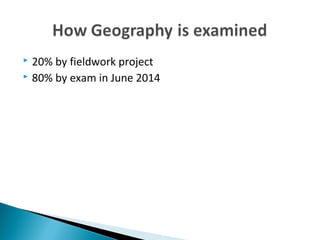
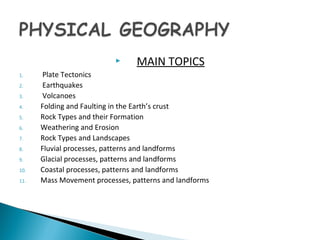
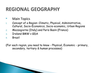
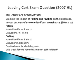
IInnttrroodduuccttiioonn ttoo LLeeaavviinngg 
CCeerrttiiffiiccaattee GGeeooggrraapphhyy
 Town and City Planning, Construction, Civil 
Engineering, Statistical Analysis, Agriculture, Civil 
Service, Teaching, Energy Supplies, Military, Met 
Eireann, Transport etc...
 Physical Geography 
 Methods of Geographical analysis 
 Regional Geography 
 “Elective” Section (either economic or human) 
 Higher level students study an extra section (the 
“option”)
 Textbook: Planet & People 
 Hardback Folder 
 Dividers 
 Ruler, pencil, etc
 20% by fieldwork project 
 80% by exam in June 2014
 MAIN TOPICS 
1. Plate Tectonics 
2. Earthquakes 
3. Volcanoes 
4. Folding and Faulting in the Earth’s crust 
5. Rock Types and their Formation 
6. Weathering and Erosion 
7. Rock Types and Landscapes 
8. Fluvial processes, patterns and landforms 
9. Glacial processes, patterns and landforms 
10. Coastal processes, patterns and landforms 
11. Mass Movement processes, patterns and landforms
 Main Topics 
1. Concept of a Region: Climatic, Physical, Administrative, 
Cultural, Socio-Economics, Socio-economic, Urban Regions 
2. Mezzogiorno (Italy) and Paris Basin (France) 
3. Ireland BMW v GDA 
4. Brazil 
(For each region, you need to know - Physical, Economic - primary, 
secondary, tertiary & human processes)
 The examiners look for the numbers of SRPs in what 
you are writing. 
 SRP stands for Significant Relevant Point 
 A SRP is a single piece of factual information, to which 
an examiner will assign a mark weighting as prescribed 
by the marking scheme outlined by the State 
Examinations Commission. 
 SRP = 2 marks at Higher Level, 3 Marks at Ordinary.
STRUCTURES OF DEFORMATION 
Examine the impact of folding and faulting on the landscape. 
In your answer refer to one landform in each case. (30 marks) 
Folding 
Named landform: 2 marks 
Discussion: 7(6) x SRPs 
Faulting 
Named landform: 2 marks 
Discussion: 6 (7) x SRPs 
Credit relevant labelled diagrams. 
Give credit for one named example of each landform

Courseoutline lc geog

  • 1.
    IInnttrroodduuccttiioonn ttoo LLeeaavviinngg CCeerrttiiffiiccaattee GGeeooggrraapphhyy
  • 2.
     Town andCity Planning, Construction, Civil Engineering, Statistical Analysis, Agriculture, Civil Service, Teaching, Energy Supplies, Military, Met Eireann, Transport etc...
  • 3.
     Physical Geography  Methods of Geographical analysis  Regional Geography  “Elective” Section (either economic or human)  Higher level students study an extra section (the “option”)
  • 4.
     Textbook: Planet& People  Hardback Folder  Dividers  Ruler, pencil, etc
  • 5.
     20% byfieldwork project  80% by exam in June 2014
  • 6.
     MAIN TOPICS 1. Plate Tectonics 2. Earthquakes 3. Volcanoes 4. Folding and Faulting in the Earth’s crust 5. Rock Types and their Formation 6. Weathering and Erosion 7. Rock Types and Landscapes 8. Fluvial processes, patterns and landforms 9. Glacial processes, patterns and landforms 10. Coastal processes, patterns and landforms 11. Mass Movement processes, patterns and landforms
  • 7.
     Main Topics 1. Concept of a Region: Climatic, Physical, Administrative, Cultural, Socio-Economics, Socio-economic, Urban Regions 2. Mezzogiorno (Italy) and Paris Basin (France) 3. Ireland BMW v GDA 4. Brazil (For each region, you need to know - Physical, Economic - primary, secondary, tertiary & human processes)
  • 9.
     The examinerslook for the numbers of SRPs in what you are writing.  SRP stands for Significant Relevant Point  A SRP is a single piece of factual information, to which an examiner will assign a mark weighting as prescribed by the marking scheme outlined by the State Examinations Commission.  SRP = 2 marks at Higher Level, 3 Marks at Ordinary.
  • 10.
    STRUCTURES OF DEFORMATION Examine the impact of folding and faulting on the landscape. In your answer refer to one landform in each case. (30 marks) Folding Named landform: 2 marks Discussion: 7(6) x SRPs Faulting Named landform: 2 marks Discussion: 6 (7) x SRPs Credit relevant labelled diagrams. Give credit for one named example of each landform