Malaysia is a Southeast Asian country located in the South China Sea, bordering Indonesia. It has a tropical climate and terrain that includes rainforests and the Kelanton River. Malaysia has a population of over 27 million and its major industries include electronics and palm oil. The country has a constitutional monarchy form of government and its top trade partners are Australia, Thailand, the US, China and Japan.
GEOGRAPHY YEAR 9: NIGERIA. Presentation suitable for Geography Year 9, which contains: geography, borders, maps, flags, current leaders, etymology, currency, area, early and modern history, governance, foreign relations, military, topography and relief forms, rivers and lakes, climate, biodiversity, economy, natural resources, population and density, capital, largest cities, ethnic groups, language, religion, health system, education system and literacy, culture, personalities.
This is a country report over Nigeria that was done for my International Business course. I presented over the culture, economy, geography, government, and the correct ways to do business in Nigeria.
Canada is going through considerable pressure in terms of achieving economic growth about 2.0%. This presentation will look at areas like real estate, retail sales, business investment, productivity, exports, labour and debt and deficits
This presentation was written in ChatGPT in 45 minutes to prove something.
Zimbabwe is a landlocked country located in Southern Africa, with a rich history and diverse culture. The country has a land area of 390,757 square kilometers, with a climate characterized by a rainy season from November to March and a dry season from April to October. Zimbabwe has a population of over 14 million people, with a diversity of ethnic groups and traditional customs and practices.
The official languages of Zimbabwe are English, Shona, and Ndebele, with many other languages commonly spoken throughout the country. Zimbabwe's main industries include agriculture, mining, and manufacturing, with major exports including tobacco, gold, and platinum.
Agriculture is particularly important to Zimbabwe's economy, with major crops including maize, tobacco, and cotton, and livestock including cattle, goats, and sheep. The country is also rich in mineral resources, with significant deposits of platinum and diamonds.
Zimbabwe has a diverse range of tourist attractions, including wildlife parks, historical sites, and cultural festivals. The country's healthcare and education systems face significant challenges, and the government has implemented various initiatives to address these issues.
Zimbabwe's political system is a presidential republic, with the ruling party being ZANU-PF and the main opposition party being the MDC-A. The country faces a range of challenges, including economic instability, political turmoil, limited access to basic services, and climate change. However, efforts are ongoing to address these challenges and promote sustainable development in Zimbabwe.
If you are interested in learning more about Zimbabwe, there are many resources available online, including government websites, travel guides, and news sources.
single parents, the elderly, refugees, and workers in low-paid ser.docxjennifer822
single parents, the elderly, refugees, and workers in low-paid service-sector jobs are also diminishing the overall ranking of Australia and New Zealand as places where everyone can make a good living. Monetary measures such as gross domestic product (GDP) and PPP are of limited use where many people are living in econ- omies based on exchanges and barter or on subsistence. The con- cept of subsistence affluence has been used to describe Pacific Island societies. In these societies, monetary incomes may be low, but local resources such as coconut and fish provide a rea- sonable diet, and extended family and reciprocal support pre- vent serious deprivation. Adequate diets and relatively effective health and education systems contribute to comparatively high life expectancies and literacy and low infant mortality through- out the Pacific Islands. Literacy is above 90% for both men and women in much of the region. Notably, Papua New Guinea, Kiri- bati, and Vanuatu have higher infant mortality and lower literacy than other parts of Oceania. Territory and Politics Oceania has seen substantial political changes in recent years, including the shift in alignment from Europe to North America and Asia and the challenges of coping with its relative geo- graphic isolation within a global economy. The stability of some independent democracies and dependencies has been threatened by internal tensions. Political and economic inte- gration has been sought through regional cooperation agree- ments. And inequalities within Australia and New Zealand have highlighted the conditions of indigenous groups, while at the same time, these countries have embraced multicultural identities. Regional Cooperation Regional agreements include the South Pacific Commission founded in 1947, which focuses on social and economic development and includes 21 island nations and territories, Australia, New Zealand, the United States, France, and the United Kingdom. The Pacific Islands Forum, established in 1971, promotes discussion and cooperation on trade, fisheries, and tourism among all the independent and self-governing states of Oceania. It has sup- ported maritime territorial rights and a nuclear-free Pacific as well as the independence goals of French Polynesia and New Caledonia. In 2000, the Forum legitimized peacekeeping military operations led by New Zealand and Australia in the Solomon Islands and Nauru, and in 2009 Fiji was suspended until it held democratic elections in 2014. The Pacific Island Countries Trade Agreements remove trade barriers within the region. Australia and New Zealand are members of larger economic and political alliances such as the 21 member Asia-Pacific Eco- nomic Cooperation group (APEC), which also includes Papua New Guinea and focuses on improving transportation links and liberalizing regional trade around the Pacific Rim. Both Australia and New Zealand have been able to take advantage of APEC to increase exports to Asia, especially to Japan. Ind.
2024.06.01 Introducing a competency framework for languag learning materials ...Sandy Millin
http://sandymillin.wordpress.com/iateflwebinar2024
Published classroom materials form the basis of syllabuses, drive teacher professional development, and have a potentially huge influence on learners, teachers and education systems. All teachers also create their own materials, whether a few sentences on a blackboard, a highly-structured fully-realised online course, or anything in between. Despite this, the knowledge and skills needed to create effective language learning materials are rarely part of teacher training, and are mostly learnt by trial and error.
Knowledge and skills frameworks, generally called competency frameworks, for ELT teachers, trainers and managers have existed for a few years now. However, until I created one for my MA dissertation, there wasn’t one drawing together what we need to know and do to be able to effectively produce language learning materials.
This webinar will introduce you to my framework, highlighting the key competencies I identified from my research. It will also show how anybody involved in language teaching (any language, not just English!), teacher training, managing schools or developing language learning materials can benefit from using the framework.
Instructions for Submissions thorugh G- Classroom.pptxJheel Barad
This presentation provides a briefing on how to upload submissions and documents in Google Classroom. It was prepared as part of an orientation for new Sainik School in-service teacher trainees. As a training officer, my goal is to ensure that you are comfortable and proficient with this essential tool for managing assignments and fostering student engagement.
This is a presentation by Dada Robert in a Your Skill Boost masterclass organised by the Excellence Foundation for South Sudan (EFSS) on Saturday, the 25th and Sunday, the 26th of May 2024.
He discussed the concept of quality improvement, emphasizing its applicability to various aspects of life, including personal, project, and program improvements. He defined quality as doing the right thing at the right time in the right way to achieve the best possible results and discussed the concept of the "gap" between what we know and what we do, and how this gap represents the areas we need to improve. He explained the scientific approach to quality improvement, which involves systematic performance analysis, testing and learning, and implementing change ideas. He also highlighted the importance of client focus and a team approach to quality improvement.
How to Make a Field invisible in Odoo 17Celine George
It is possible to hide or invisible some fields in odoo. Commonly using “invisible” attribute in the field definition to invisible the fields. This slide will show how to make a field invisible in odoo 17.
Palestine last event orientationfvgnh .pptxRaedMohamed3
An EFL lesson about the current events in Palestine. It is intended to be for intermediate students who wish to increase their listening skills through a short lesson in power point.
The French Revolution, which began in 1789, was a period of radical social and political upheaval in France. It marked the decline of absolute monarchies, the rise of secular and democratic republics, and the eventual rise of Napoleon Bonaparte. This revolutionary period is crucial in understanding the transition from feudalism to modernity in Europe.
For more information, visit-www.vavaclasses.com
How to Create Map Views in the Odoo 17 ERPCeline George
The map views are useful for providing a geographical representation of data. They allow users to visualize and analyze the data in a more intuitive manner.
The Indian economy is classified into different sectors to simplify the analysis and understanding of economic activities. For Class 10, it's essential to grasp the sectors of the Indian economy, understand their characteristics, and recognize their importance. This guide will provide detailed notes on the Sectors of the Indian Economy Class 10, using specific long-tail keywords to enhance comprehension.
For more information, visit-www.vavaclasses.com
The Art Pastor's Guide to Sabbath | Steve ThomasonSteve Thomason
What is the purpose of the Sabbath Law in the Torah. It is interesting to compare how the context of the law shifts from Exodus to Deuteronomy. Who gets to rest, and why?
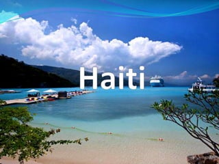
3. Description of Haiti Haiti is a small country; 10,714 sq. mi. The Climate is Tropical. The location is in the Caribbean Sea. On January 12, 2011 the population was 9,719,932. Haiti’s Flag:
4. Geographic Features of Haiti The land regions are Coastal, moutains, and valleys. Major Lakes Lake Azuei Lake of Miragoane Trou Caiman Major Rivers Artibonite Riviere de la Grand’ Anse Riviere de Cavaillon Indigenous Flora and Fauna tall pines Cacti Caiman Flamingos Special Points of Interest Musée de Pantheon the Basilica of Notre Dame Vacation Tour The United States warns travelers of the potential dangers of vacationing here, guided tours are recommended.
5. History The history of Haiti began on December 5, 1492 when Christopher Columbus landed on the island of Hispaniola for Spain Haiti’s major earthquake a few years negatively affected not only Haiti’s economy, but the rest of the world’s. In the past year, Haiti’s exiled Jean-Claude Duvalier returned from his exiled.
6. Political Type of Government republic Government Leaders The President of the Republic is ElieLescot
7. Economy Industry Haiti produced baseballs and other sporting goods. Exports apparel, manufactures, oils, cocoa, mangoes, coffee Imports food, manufactured goods, machinery and transport equipment, fuels, raw materials Economic Status Haiti is a poor country. Major Trade Partners United States, Dominican Republic Trade Associations China, Netherlands Antilles Sanctions The United States threatened Haiti with a sanction
8. Daily Life Standard of living Haiti’s standard of living is extraordinarily low. Literacy The literacy rate in Haiti is about 53%. Clothing People in Haiti don’t have much clothing, just the basics. Internet Usage 10.1% of the Haitian population uses internet.
9. Cultural Traditions Haiti shares some African traditions in culture such as cuisine, music, dance, dress, ritual, and religion Customs In February, Haiti holds Carnival. A musical festival is celebrated before Easter Religions Christianity Voodoo Foods Haiti’s cuisine blends African, French, and Spanish influences Music and Dance The Meringue is a very popular dance here. Interesting facts The official languages of Haiti include French and Haitian Creole.
10. Conclusion on Haiti Haiti is a small, impoverished island. Facts More than 10% of Haitian children die before age five Haiti has the highest percentage of orphans of any country in the Western Hemisphere. Only about 10% of all Haitian children enrolled in elementary school go on to a high school. I learned that only a small amount of Haiti’s people use internet, or go on to high school.
13. Description of Libya The size of Libya is 679,362 sq mi. The climate is Mediterranean along the coast, and has an extreme desert interior It is located in Africa and surrounded by Tusinia, Niger, Algeria, Chad, Sudan, and Egypt. July 2010 est. of population was 6,461,454. Flag:
14. Geographic Features of Libya The main land regions of Libya are dry grasslands and deserts. The coastline of Libya borders the Mediterranean sea, and in Libya there is the Great Man-Made River Indigenous Flora: Tahara Brankbakh Indigenous Fauna: Fennec Fox Long eared Hedgehog Carcal Points of Interest Tripoli’s Jamahiriya Museum Akaku’s desert Vacation Tour Top rated hotel- Attawakfeek hotel Top rated thing to do- Leptis Magna Top rated resturant-Al-Althar
15. History of Libya Early 16th century the Barbary Coast attracted the attention of two powerful Mediterranean states; Spain and Turkey. The Spanish-Turkish rivalry lasted most of he 16thcentury, but in the end the Turks were victorious. Libya’s current unrest is causing international uproar. Recently, air raids have targeted Gadhafi’s stronghold in Libya.
16. Political Type of government Jamahiriya-(a state of the masses) governed by the populace through local councils Government Leaders Leader- Muammar Abu Minyar al-Ghadhafi
17. Economy of Libya Industry oil Exports Oil, Gas , Iron ,Gold ,Phosphate Imports machines, transport equipment, semi finished goods, consumer products and food. Economic status Libya is considered a rich country. Major Trade Partners Italy, Germany, Spain, France, Sudan Trade Associations Italy, Germany, Spain, France, Sudan Sanction United States announced sanctions against the Libyan government recently The UN and EU have applied additional financial sanctions against Libya
18. Daily Life in Libya Standard of Living The living standards are among the highest in Africa Literacy rate 82.6% Clothing traditionally, men wear loose cotton shirts upon trousers and cover themselves with a cloak, and wear flat brimless caps. Traditionally, women wear full length robes. Most of the urban Libyan population is turning towards western clothing styles. Internet usage In a 2008 estimate, 5.1% of the population uses internet.
19. Cultural Traditions arts such as weaving, embroidery, metal engraving, and leatherwork festivals, horse races, and folk dances Customs Men shake hands. A man must wait for a woman to extend her hand first. A bowl of perfumed water may be passed around a table before a meal. Three fingers are dipped into the water as a form of ritual cleansing. Religions Islam Small amount of people are Roman Catholic Foods Libyan food is influenced by traditions of the Mediterranean and North Africa, with an Italian influence Popular dishes include: SharbaLibiya and Bazin. Music and Dance Andalusi music is popular in Libya Hagallah Facts The life expectancy is 76 Arabic, Italian, English are all spoken in Libya.
20. Conclusion Libya is a large, mostly desert African country currently facing an uprising. Facts Poor soil and hot climatic conditions force Libya to import most of their food. Libya has the highest literacy rate of any country in North Africa I learned that the Libyan flag is completely green, with no design.
23. Description of Lesotho The size of Lesotho is 11,720 sq mi. Lesotho has a continental climate, meaning they have hot summers and cold winters. Lesotho is surrounded by South Africa. In a 2009 count, the population of Lesotho was 2,066,919. Flag:
24. Geographic Features of Lesotho The land regions of Lesotho include lowlands, mountain ranges, and foothills. Lesotho is landlocked, but a major river is the Orange river. Indigenous Flora: Cape willows Cheche bush Indigenous Fauna: Bearded vulture Hyrax Leopards Special points of interest Maletsunyane falls Sani Pass Vacation Tour: Best hotel- Malibu Moutain lodge Best restaurant- The Rendezvous Top rated attraction- Lesotho Mountain Kingdom
25. History of Lesotho Lesotho was once ruled under the UK and was originally named Basutoland, but when it gained independence, it was renamed the Kingdom of Lesotho. Constitutional government was restored in 1993 after seven years of military rule. Impact on World Lesotho has the third highest HIV prevalence in the world Current Event Lesotho is considering investments from textile companies that are threatening to close down factories in South Africa due to an increased minimum wage
26. Political Type of Government Parliamentary constitutional monarchy Government Leaders King Letsie III Prime Minister PakalithaBethuelMosisili
27. Economy Industry weaving, tire remodeling, production of textiles and diamond processing. Exports clothing, ceramics, cut diamonds, inedible crude materials, furniture, miscellaneous manufactured wool and goods. Imports corn, clothing, building materials, vehicles, petroleum products, machinery, and medicines Economic Status Lesotho is a poor country Major Trade Partners South Africa, Botswana, Swaziland, Namibia, North America, and Europe. Trade Associations South Africa, Botswana, Swaziland, Namibia, North America, and Europe. Sanctions Lesotho has a sanction on Maseru
28. Daily Life Standard of Living Rural areas in Lesotho are marked by poverty and inadequate access to health care. people with access to land and employment enjoy a reasonable standard of living. Literacy 84.8% of the population are literate Clothing Some of the Population in Libya dress fairly Western, but the most acceptable form of clothing for a woman is still the dress, and her hair is expected to be covered with a scarf, head cloth, or hat. Internet Usage In a 2008 count, 3.6% of Lesotho uses internet
29. Cultural Traditions Sotho cultural performances, where storytellers, dancers, and musicians join with audience chanting, clapping, and singing to retell ancient folktales Hand making instruments Customs Upon marriage, a woman is expected to leave her family to live with the family of her husband. Religions Christianity is the dominant religion in Lesotho Foods Meat such as beef, mutton, goat or chicken is eaten on special occasions. Traditional foods include sugar beans, maize, pumpkin and wild spinach as the staple foods Music and Dance Famo and sub-saharanAfropop styles, jazz, kwaito, and reggae There are mokhibo and litolobonya dances for women, and ntlamo and mohobelo dances for men. Unique Facts The life expectancy is 52 years.
30. Conclusion Lesotho is a small, poor, landlocked country in south Africa. Facts AIDS is the main health problem in Lesotho Lesotho is called by various names like ‘Roof of Africa’, ‘Mountain Kingdom’ and ‘Kingdom in the Sky’. I learned that Lesotho used to be under the control of the United Kingdom
33. Description of Guam The size of Guam is 212 sq. miles. Guam’s climate is warm year-round. Guam is in the Pacific ocean, and is located near China, South Korea, and Indonesia In a 2009 count, the population of Guam was 177,718. Flag:
34. Geographic features of Guam Guam is an Island, with coral reefs and sandy beaches. Guam is surrounded by the Phillipine Sea and the North Pacific Ocean. Indigenous Flora Cycas Fadang tree Indigenous Fauna Cockaroachesare rampant in Guam Points of Interest Latte Stone Park Two lovers point Vacation Tour Top rated hotel- Hyatt Regency Guam Top rated restaurant- Proa restaurant in Tumon Top rated attraction- Two lovers point
35. History In 1898, Guam was surrendered to the United States by Spain. In 1941, Japan captured Guam from the United States , but it was recovered three years later. It impacts the world by giving the United States a military base in the eastern hemisphere, and also acts as a vacation spot Guam recently signed a bill to ban shark finning.
36. Political Type of government NA; territory of the US Government Leaders Barack Obama
37. Economy Industry Tourism Exports refined petroleum products, construction materials, fish, food and beverage products Imports petroleum and petroleum products, food, manufactured goods Economic Status Guam’s status depends on US military spending and tourism Major Trade Partners Japan, Singapore, United Kingdom Trade Associations Japan, Singapore, United Kingdom Sanctions none
38. Daily Life Standard of Living The cost to live on Guam is staggeringly high, but it’s a fair standard of living. Literacy 99% of the country is literate Clothing Spanish influence is apparent in clothing styles Internet Usage 48.4%
39. Cultural Traditions Liberation Day in July Fiestas legends Customs Respect for elders and authority figures Respect is demonstrated by bending over and sniffing an older person's right hand. Religions The major religion is Roman Catholic Foods roast pig, chicken, barbecue fish, seafood, red rice, potato salad, bananas, taro, fenadeneglota, and vegetable salad. Music and Dance BailanLina’la’, BailanUritao Modern music includes elements of American, Spanish, Filipino, and Polynesian music. Unique Facts Mariana Trench, the deepest part of the ocean in the world, is in the area surrounding Guam.
40. Conclusion Guam is a small Asian Island under the control of the United States Facts Guam is one of the most strategically important placed US military bases. The official name of Guam is the ‘Territory of Guam’. I leaned that Guam is one of the most important US military bases,
43. Description of Malaysia The size of Malaysia is 128000 sq.miles The climate of Malaysia is normally warm and humid. Malaysia borders Indonesia, and is in the South China Sea. In a 2009 count, the population of Malaysia was 27,467,837. Flag:
44. Geographic features of Malaysia Malaysia has tropical rainforests. The Kelanton river is the major river in Malaysia. It is surrounded by the South China Sea. Indigenous Flora Rafflesia Hibiscus Indigenous Fauna Tigers Elephants 150 species of snakes, 16 of which are venomous including the King Cobra Vacation Tour Top rated hotel- Swiss-Garden DamaiLaut Top rated restaurant- Mahan Kitchen Top rated attraction- Petronas twin towers
45. History During the late 18th and 19th centuries, Great Britain established colonies and protectorates in the area of current Malaysia, which were occupied by Japan from 1942 to 1945. Malaysia lends itself to the world as a wonderful vacation spot with natural beauty and wildlife Malaysia is turning to science in order to train athletes in hopes of gaining Malaysia’s first Olympic gold medal in London next year.
46. Political Type of Government Constitutional monarchy Government Leaders King- Sultan MIZAN ZainalAbidin Head of government- Prime Minister Mohamed NAJIB bin Abdul Razak
47. Economy Industry electronics, oil and gas, palm oil and rubber Exports Cars, ore, diamonds and clothing. Imports beef and mutton, rice, Japanese food, and apples Economic Status Major Trade Partners Australia, Thailand, America, China, Japan Trade Associations New Zealand, India Sanctions Malaysia has a sanction on Iran.
48. Daily Life Standard of Living Literacy 88.7% of the population is literate Clothing Women Traditionally, women wear a knee length blouse over a long skirt. Traditional clothing for men in Malaysia consists of a silk or cotton skirt and shirt with a scarf like piece of cloth tied around his waist. Internet Usage 55.8% of the population uses internet
49. Cultural Traditions The Bersanding Ceremony is followed by Kenduri, a wedding feast. Customs introduce the ladies first and then move on to introduce men. One should not touch other people’s top portion of the head. Religions Islam Foods Fish are popular in Malaysian cuisine Pork isn’t eaten, because it goes against their religious beliefs Rice is a staple in Malaysian cuisine Music and Dance Music Music in Malaysia is influenced by Indonesian, Thai, Portuguese, Filipino and Chinese music. Dance Zapin, Joget, Silat, Mak Yong Unique Facts the Bintagor trees, found only in Sarawak, is believed to contain properties that could help fight the virus that causes AIDS.
50. Conclusion Malaysia is an Asian country bordering the South China Sea. Facts Malaysia is home to many venomous snakes, including the infamous king cobra. I learned that Pork isn’t eaten in Malaysia, due to religious beliefs.
53. Description of Hungary The size of Hungary is 35919 sq. miles. Hungary has a continental climate meaning hot summers, and cold winters. Hungary is located in eastern Central Europe bordered by Austria, Slovakia, the Ukraine, Romania, Serbia, Croatia, and Slovenia. In a 2009 count, the population of Hungary was 10,022,302. Flag:
54. Geographic Features of Hungary Hungary has plains, hills, mountains, and forests. The Danube river and Tisza river are the two major Hungarian rivers. Lake Balaton, the greatest lake of Central Europe is found here. Indigenous Flora Oak trees Beech tress Indigenous Fauna Fox Deer Hare Vacation Tour Hungary is considered in the list of top 15 tourist destinations in the world Top rated hotel- Best Western hotel Hungaria Top rated restaurant- Café Kor Top rated attraction- Budapest
55. History Hungary was once a part of the Austro-Hungarian empire, which collapsed after World War I. The country fell under Communist rule following World War II. Hungary played a large part in both World Wars Hungary recently declared Elvis Presley an honorary citizen of Budapest.
56. Political Type of government Republic Government Leaders chief of state: President Pal SCHMITT head of government: Prime Minister Viktor ORBAN
57. Economy Industry developing steel, machine tools, buses, diesel engines and locomotives, television sets, radios, electric light bulbs and fluorescent lamps, telecommunications equipment, refrigerators, washing machines, medical apparatus and other precision engineering equipment, pharmaceuticals, and petrochemical products. Exports meat, poultry, grain, and wine Imports electronics, machinery, petroleum products, plastics, vehicles, iron and steel products, chemicals Economic Status Middle income country Major Trade Partners Germany Trade Associations Italy, Romania, Austria Sanctions Hungary has a sanction on Serbia, and the EU is threatening Hungary with a sanction.
58. Daily Life Standard of Living The standard of living is fairly good. Literacy 99.4% of the population is literate. Clothing Styles vary from jeans and sweaters, to skirts and blouses. Internet usage 58.5% of the population uses internet.
59. Cultural Traditions Nativity plays at Christmas, painting at Easter, and Busojaras Customs Handshakes are the common gesture of greeting, no matter how well you know someone. Religions Roman Catholic Foods goulash, halaszle, and palacsintaare popular dishes. Pork is the meat of choice. Music and Dance Folk and classical music both have major Hungarian contributions. Unique Facts The average life expectancy for women is 8 years longer than men’s.
60. Conclusion Hungary is a landlocked country situated in Central Europe. In 2004, Hungary joined the European Union. Facts Budapest is one of the top tourist destinations in the world. I learned that
63. Description of the Northern Mariana Islands The size of the Northern Mariana Islands is 176.5 sq. miles. The Northern Mariana Islands have a tropical climate tempered by the trade winds. The Northern Mariana Islands are in Asia, bordered by the Phillipine seas and North Pacific Islands In a 2010 estimate, the population was 48300. Flag:
64. Geographic Features of the Northern Mariana Islands The Northern Mariana Islands are home to volcanoes and coral reefs. The islands are surrounded by the Philippine sea and the North Pacific Sea. Indigenous Flora Hibiscus Plumeria Indigenous Fauna Fairy tern Rufousferntail Vacation Tour Top rated hotel- Aqua Resort Club Saipan [geared more towards Asian travelers] Top rated restaurant- Casa Urashima Top rated attraction- Managaha Island
65. History The Northern Mariana islands were sighted by Ferdinand Magellan in 1521 while he was sailing for Spain, but the islands were not settled by Europeans until 1668. The Mariana Islands were ruled consecutively by Spain, Germany, and Japan until they became part of the United States in Nov. 1986. Due to the many different countries that claimed the Northern Mariana Islands at different times, it has many different influences on it’s culture. A company was recently charged with a fine of almost a million dollars for violating the Clean Air Act.
66. Political Type of government commonwealth; self-governing with locally elected governor, lieutenant governor, and legislature Government leaders Government leaders chief of state: President Barack H. Obama head of government: Governor Benigno R. Fitial
67. Economy Industry banking, construction, fishing, garment, tourism, handicrafts Exports garments Imports food, construction equipment and materials, petroleum products Economic Status The economic status is heavily influenced by the United States Major Tradepartners U.S., Japan Trade Associations U.S., Japan Sanctions none
68. Daily Life Standard of Living The standard of living is fairly good. Literacy 97% of the population is literate. Clothing Dress in the Northern Mariana islands is very Americanized. Internet Usage In a 2003 estimate about 10,000 people of the population use internet.
69. Cultural Traditions Fiestan Luta Customs Casual hello’s are often nothing more than a eyebrow raise of recognition. Religions Christian Foods rice is a popular food choice Music and Dance folk music of the Chamorro is popular American, German, Spanish and Japanese influence their music. Unique Facts Only 6 of the 16 islands that make up the Northern Mariana Islands are inhabited.
70. Conclusion The Northern Mariana Islands are a commonwealth of the United States, located in Asia, which relies heavily on tourism. Facts Most of the tourism that the island receives is from Japan. The original inhabitants of the Northern Mariana Islands were the Chamorro.
71. Works Cited http://www.everyculture.com/ https://www.cia.gov/library/publications/the-world-factbook/index.html http://www.cbsnews.com/stories/2007/10/03/country_facts/ http://www.britannica.com/