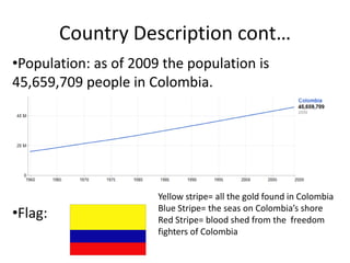
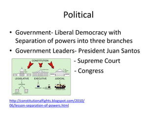
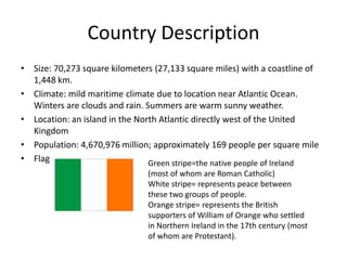
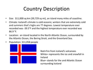
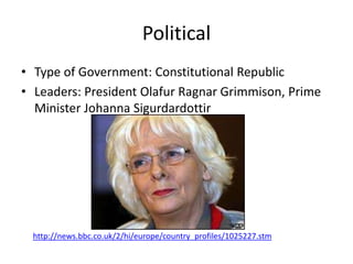
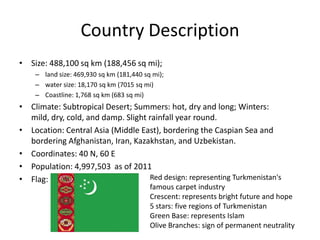
SlideShare a Scribd company logo
7 countries Project


    By: Erich Schill
Erich Schill                   Colombia


http://www.33ff.com/flags/worldflags/Colombia_flag.html same
hyperlink for flag on slide 5
Country Map
                                            Legend:
                                    N       :    = River
                                W       E        = City
                                    S            = Capital
                                                 = Beach
                                                 = Famous Church
                                                 = National Park


http://www.lonelyplanet.com/maps/south-america/colombia/
Country Description
                               •Location: located in
• Size: Area of 1,138,910
                               northwestern corner of
  square kilometers and a      South America. Colombia
  total coastline of 1,993     borders to the west with
  mi.                          Venezuela and Brazil; to the
• Rural and Urban              south with Ecuador and
  residence: 70% of the        Peru; to the North with the
  population lives in cities   Panama, the Atlantic
  and 30% in urban areas.      Ocean, through the
• Climate: tropical and        Caribbean Sea; and to the
  isothermal due to            west with Panama and the
  location near to the         Pacific Ocean.
  equator.
Country Description cont…
•Population: as of 2009 the population is
45,659,709 people in Colombia.


                       Yellow stripe= all the gold found in Colombia
•Flag:                 Blue Stripe= the seas on Colombia’s shore
                       Red Stripe= blood shed from the freedom
                       fighters of Colombia
Geographic Features- Land Regions
• Land Regions: There are
  six major land regions in
  Colombia that include
  the Andean Region, the
  Andean Region, Caribe
  Region (Caribbean
  Region), Pacific
  Region, Amazon
  Region, and the
  Orinoquía Region.
         http://en.wikipedia.org/wiki/Natural_regions_of_Colombia
Geographic Features- Bodies of water
• Rivers: There are around 120 rivers all
  throughout Colombia. Some notable ones
  include the Cacuca and the Magdalena river.
• Lakes: Some notable lakes include Lake Tota,
  Calima Lake, and Lake Guatavita.
• Oceans: the Pacific Ocean to the west.
• Seas: Caribbean sea to the northwest
Geographic Features-Fauna and Flora
• The fauna and flora of Colombia vary greatly
  because of its huge diversity and tropical
  climates.
• Fauna-tigers, deer, sloths, anteaters, bears,
  monkeys, pigs, weasels raccoons, moose,
  tapir, rodents, varieties of feline, etc.
• Flora-could be its variety of green-foliage
  trees. These trees include walnut, cedar, oak,
  ginger, balsam, mahogany, etc.
Geographic Features- Points of Interest
• Special points of interest in Colombia includes
  attractions such as the Gold Museum in Bogota.
Or the Walled City in
Cartagena (below)


                              Link for picture above


    Link for picture above
History
• In 1510 Spaniards founded Darien, a settlement on the American
  mainland
• In 1538 this settlement was brought up to be a colony known as
  New Granada which lasted until 1861.
• Then in 1824 Bolivar won it in the battle of Boyacá in Colombia and
  created the Republic of Greater Colombia.
• Then later in 1840 a small civil war broke out after relative peace
  which sparked these name changes
- 1861 United States of New Granada
- 1863 United States of Colombia
- 1885 Republic of Colombia
• Lastly in 1899 another civil war broke out, the war of a thousand
  days, which lasted until 1902 and gained Colombia’s complete
  independence in 1903.
History cont…
• Colombia contributed anti- efforts such as drug
  trafficking. Colombia set up an anti-drug group
  called Plan Colombia to eliminate cocaine trade.
• Another contribution includes the independence
  for the country of Panama granted by Colombia
  in 1914.
• In WWII Colombia was with the anti-axis or allied
  group.
• Major wars include WWII, war of a thousand
  days, and lastly slightly involved with Spanish
  Conquest.
Current Events
• A couple of the most current events in the
  past year include:
  - Most infamous terrorist group is still existing in
    Colombia known as FARC.
  - Paramilitary Groups are the causes of 70% of
    murders in Colombia when they job is to have self
    defense and protect Colombia.
  - Juan Manuel Santos inaugurated 7th Aug 2010.
Political
• Government- Liberal Democracy with
  Separation of powers into three branches
• Government Leaders- President Juan Santos
                     - Supreme Court
                     - Congress


http://constitutionalfights.blogspot.com/2010/
06/lesson-separation-of-powers.html
Economy
• Free market economy with investment ties to U.S.
• Main industries include textile, oil, sloshing, beverages,
  chemicals, cement, gold, coal, and emeralds.
• Exports: petroleum, coffee, coal, nickels, emeralds
• Imports: fuels, electricity, consumer goods, chemicals,
  paper products, and industrial/transportation equipment.
• Trade Partners: United States, China, and Brazil
• Trade Associations: CAN (Andean Community of Nations)
  and SACN Union of South American Nations.
• Sanctions: Venezuela one of major traders blocks trade
  with Colombia in 2009
Daily Life
• The Colombian standard of living has increased over
  the past three years.
• Labor Force:20.81 million
• Unemployment Rate: 11.1%
• Population below poverty line: 49.2%
• Literacy Rate: 92.7%
• Life expectancy: males 69 years and females 74 years
• Clothing: trousers, sleepwear, shirts, shorts, polo shirts,
  jackets, swim trunks. All according to the weather
• Internet Usage: (1993) 0% to (2008) 38.5% of the
  population
Cultural
• Traditions: This all depends upon the region you live on. An example
  of some notable ones are: December 7th all houses are lit with
  candles, also for Christmas most Columbian families make Bunelos
  with Natilla.
• Customs: The variety of tropical fruit, the way they greet people
  (shaking elbow with their hands), and resentment towards car
  doors being slammed are examples of some customs practiced in
  Bogota
• Religions: Catholicism, Islam, Protestants, and Judaists
• Foods: mostly meat, Arroz con Coco (rice with
  milk), Buneuelos, Quesillos (cream cheese in bananas)
• Music: varied from accordion to rap pretty much included all music
  types, Porro (big band music) and Cumbia
• Dance: Pasillo (waltz), Vallenato (bae guitar dances), Cumbia
  (African dance)
Fun Facts
• There are 32 states in Colombia
• Colombia’s official name is Republic of Congo
• Colombia has 95% of the worlds emeralds in
  the city of Boyacá
• Peso is he currency of Colombia
• Colombia is one of the largest Spanish-
  speaking countries in the world
• Colombia’s capital and largest city is Bogota
Sporting Event
• The Fifa U-20 World Cup will be held in
  Colombia after being postponed from Libya
  due to internal issues.
• Colombia automatically qualifies for this
  World Cup because they are the host country.
• Colombia has been to the World Cup four
  times in the past.
• Event will take place between July 29 and
  August 20.
Wrap-Up
• I fund it interesting that despite the fact that
  Colombia completely gained its independence
  around 100 years ago they are constantly
  excelling in every aspect such as people,
  economy, technologies, balance of trade, and
  with their good government and culture.
Erich Schill                               Ireland


http://www.33ff.com/flags/worldflags/Ireland_flag.html
Country
 Map


          http://geology.com/world/ireland-satellite-image.shtml
Country Description
• Size: 70,273 square kilometers (27,133 square miles) with a coastline of
  1,448 km.
• Climate: mild maritime climate due to location near Atlantic Ocean.
  Winters are clouds and rain. Summers are warm sunny weather.
• Location: an island in the North Atlantic directly west of the United
  Kingdom
• Population: 4,670,976 million; approximately 169 people per square mile
• Flag                          Green stripe=the native people of Ireland
                               (most of whom are Roman Catholic)
                               White stripe= represents peace between
                               these two groups of people.
                               Orange stripe= represents the British
                               supporters of William of Orange who settled
                               in Northern Ireland in the 17th century (most
                               of whom are Protestant).
Geographic Features
• Land Regions: There are two main regions of Ireland Northern Island and The
  Republic of Ireland
• Rivers : 10 major rivers of Ireland include Shannon, Barrow, Suir, Blackwater
  (Munster), Nore, Bann, Liffey, Slaney, Boyne, and Lee.
• Lakes: Lough Neagh, Lough Ree, Lough Derg, Lough Conn, Lough Corrib, Lough
  Mask, and Lough Allen. In Irish “Lough” means “loch” or “lake.”
• Oceans and Seas: Atlantic Ocean, Celtic Sea, and Irish Sea are where Irish
  tributaries lead to and what borders Ireland.
• Fauna: -Land: hedgehogs, Irish hare, pine marten, red fox, and badgers        -
  Coastal: shark, turtle, and dophin
          - Air: over 400 species of birds, most common is swallow
• Flora: -trees: oak, beech, pine, birch, and palm
         - plants: land is mostly covered with pasture, wildflowers, fern, and
                   wild furze,
Geographic Features cont…
• Mountains: Antrim Mts., Sperrin Mts., Blue Stack Mts., Ox Mts., Wicklow
  Mts., Silver Bloom Mts., Silvermine Mts., Galtee Mts., and Blackstairs Mts.
• Points of Interest: some include

St Patrick’s Cathedral       The National Museum       Celtic Crosses(cemetery)


                                                                   Link
                                     Link

       Link
History
• First known settlements of Ireland date all the way back to B.C by
  migrating hunter-gatherers.
• The early history of Ireland spans from the 5th century to the 8th century.
• This span of time involves Ireland when they came out of the protohistoric
  (time between prehistory and history where writing was not established
  period to the Viking Age.
• A lot later in history Ireland’s war of independence (Anglo-Irish War) took
  place of the IRA (Irish Republican Army) against the British Government
• War lasted from Jan 1919 to July 1921 and the Anglo-Irish Treaty in 1922
  resulting in Ireland’s partition.
• After the independence Ireland’s population grew, economy grew, and
  way of government improved
Ireland’s Impact
• Some inventions impacting world: Chemistry (Robert Boyle), first guided
  missile (Louis Brennan), and hypodermic syringe (Francis Rynd)
• Ireland was part of the United Kingdom during WWI and was part of the
  Entente Powers.
• Ireland during WWII held a policy of neutrality while neither joining the
  Axis or Allies. Ireland was led by Eamon de Valera.
• Major Wars by Ireland include the Anglo-Irish War, War in
  Afghanistan, Walliamite War in Ireland, and the Nine Years War.
• Important current events in the past year include: Bishop of Clogher
  Joseph Duffey’s resignation is accepted by Pope Benedict XVI, Dublin was
  named the fourth city of literature, and Galway City Hall exploded.
Political
• Ireland’s type of government is Parliamentary
  Republic
• Government Leaders-                         Link


President Mary McAleese
People of Ireland
• This picture shows that the
People along with the leader
have a say in the government
Economy
•   Knowledge economy focusing on services and high-tech industries
•   Industries: steel, lead, zinc, silver, aluminum, barite, computer
    software, tourism, chemicals, textiles and clothing
•   Exports: machinery and
    equipment, computers, chemicals, pharmaceuticals, animals, and animal
    products
•   Imports: data processing equipment, petroleum, textile, clothing and
    chemicals
•   Economic Status: Ireland is ranked 48th in economy and imports 63.12 billion
    and exports 108.6 billion
•   Ireland trades with the United Kingdom and the United States mostly.
    However they also trade with France and Germany.
•   Ireland’s trade associations include EU (European Union), WTO (World Trade
    Organization), and OECD (Organization for economic and Co-operation
    development).
•   Sanctions include Belarus, Burma, Ivory Coast, Iran, Iraq, and Lebanon
Daily Life
•   Literacy: 99% for men and women; ranked 21 for literacy rates
•   Clothing: jackets, T-Shirts, khaki shorts, jeans
•   Life Expectancy: woman is 80 years and for men 75 years.
•   Internet Usage: around 53% of the population use internet in Ireland as of 2007


                                                                Link
Cultural
• Ireland’s culture is not homogenous or the same through the
  whole country. The cultures are different in the urban and
  rural areas of Ireland.
• Traditions: St. Patrick’s day, decorate Christmas
  tree, Halloween, All Saints Day, and during a wedding the man
  is dressed in a kilt originating from his clan.
• Customs: A custom in Ireland is that a sign of wealth is
  owning cattle on your farm, mass in homes, Mother’s day is
  on Sunday April, 3rd.
• Religion: In 2006 a census stated that 86.8% were Roman
  Catholic, 3% Anglican, 0.8% Islam, 0.6% Presbyterian, less
  than 5% Jewish, about 1.4% other religion, and 4.4%
  answered no religion and 2.2% failed to respond.
Cultural cont…
• Foods: Irish potatoes, cabbage, soda
  bread, bacon, dulse, Boxty, etc.
• Music: songs from
  accordion, bagpipes, flute, banjo, and flutes. These
  songs also include drinking songs and Scottish derived
  music.
• Dance: social dancing (including Ceili and set dancing)
  and performance dancing (including step dancing and
  tap dancing)

          Link                    Link
Fun Facts
• In Ireland punching someone in the face is a friendly way
  to start a fight but by pouring and wasting alcohol is
  grossly insulting.
• The three most common symbols of Ireland are the Celtic
  cross, green shamrock, and a harp.
• Ireland is a country of many rivers and lakes, lakes are
  referred to as loughs ( pronounced as locks)e.g. Lough
  Swilly.
• In 1447 mustaches were illegal in Ireland
• Ireland’s largest city and capital is Dublin.
• Ireland’s language before Irish was Gaelic.
Reaction to Japan
• Irish people helped Japan to rebuild its
  destroyed nation by donating to charities such
  as Red Cross (US) or the Shelterbox (UK)
  charity.
                                             Link


         Link
Wrap-Up
• The thing I found the most interesting about Ireland
  was that of its diverse culture, religion, and the food.
  Personally I enjoy the food because I eat Irish potatoes
  and I really enjoy them. The culture is interesting
  because it is neat how even though the Republic of
  Ireland and Northern Ireland are separated they still
  function as a country. Maybe not as the greatest one
  but a good one. Lastly I found it interesting about how
  diverse the religion is with almost every religion being
  practice and only a 1.4% of “no religion.”
• I have learned that Irish culture is very preserved and
  even though being pushed around a lot by the British
  they still keep their strong culture.
Erich Schill                                    Iceland


               http://flagspot.net/flags/is-hist.html
Country Map
                                                       Legend:
                                               N            = River
                                           W       E        = City
                                               S
                                                            = Capital
                                                            = Tourist Attraction
                                                            = National Park


http://www.lonelyplanet.com/maps/europe/iceland/
Country Description
• Size: 311,000 sq km (39,729 sq mi), an island many miles of coastline.
• Climate: Iceland’s climate is cold oceanic; winters that are extremely cold
  and summers that’s highs are 77 degrees. Lowest temperature ever
  recorded was -39.5°F and the highest temperature ever recorded was
  86.9 °F.
• Location: an island located in the North Atlantic Ocean, surrounded by
  the Atlantic Ocean, the Bering Strait, and the Greenland Sea.
• Population: 311,058 people


                                 Red=Fire from Iceland’s volcanoes
                                 White= represents the ice and snowfall in
                                 Ireland
                                 Blue= stands for the and Atlantic Ocean
                                 surrounding Iceland
Geographic Features-Land Regions
Land Regions:
1.   Höfuðborgarsvæði (capital region)
2.   Suðurnes (Southern Peninsula)
3.   Vesturland (West)
4.   Vestfirðir (Westfjords)
5.   Norðurland vestra (northwest)
6.   Norðurland eystra (northeast)
7.   Austurland (East)
8.   Suðurland (South)


                                         Link
Geographic Features
• Rivers: Most of the large rivers arise in glaciers and their flow volume in
  summer is much greater than in winter. Some of Iceland’s important rivers
  include: Þjórsá, Ölfusáá, Jökulsá á Fjöllum, Skjálfandafljót, Jökulsá á Brú,
  Lagarfljót, Skeiðará and Kuðafljót.
• Lakes: Iceland possesses several lakes those dating back to the tectonic
  age. Some major lakes include Þingvallavatn, Þórisvatn, and Öskjuvatn.
• Oceans and seas: Iceland is surrounded by the Atlantic Ocean, Denmark
  Strait, and the Greenland Sea.
• Fauna: fox, reindeer, whales seals, eiderduck, ptarmigan, and cod. Iceland
  has very few insects and they have no reptiles nor frogs.
• Flora: grass, mosses, and small shrubs.
Points of Interest
Chris Rijk-(photographer)


                            Links for
                            all photos
Early History
• Around 20,000 years ago Iceland formed from eruption of volcanoes.
• For a long time Iceland was one of the world’s largest islands uninhabited
  by humans.
• Naddoddr, according to Landnámabók, officially discovered Iceland and
  named it Snowland in the late 800s.
• In the mid 1200s Iceland signed a treaty with the Norwegian Monarchy
  establishing a union with them.
• Then later around 1380 Iceland became under a union with
  Denmark, Sweden, and Norway, known as the Kalmar Union.
• In 1814 the Kalmar union broke up and Denmark kept Iceland as a
  dependency
• On June 17, 1944, Iceland became and independent country
Impact on World
 • Instant Photography discovered by Erasmus Bartholin (right) using an
   transparent Icelandic crystal. He discovered that looking through the
   crystal doubled the objects.

•Another way Iceland impacted the world was
unfortunately by their volcanoes threatening
widespread damage to occur. This volcano is
actually a mid-ocean ridge that comes above sea
level and threatens to cause massive damage from
its explosion.


                                                             Link


         Link
Wars
• WWI- In WWI Iceland was very poor and ruled by a
  Danish king so they did not participate.
• WWII- In WWII Iceland originally fought with
  Denmark in a personal union, but then Britain and
  the United States said they would protect them and
  they cooperated with Britain and the U.S. So all in all
  Iceland stayed neutral.
• Major war- The Cod War- This war was fought
  between the United Kingdom and Iceland for fishing
  rights in the North Atlantic. This war resulted in
  Britain promising to not fish there anymore.
Current Events
• A current event is one about Mt. Kalmar of
  Iceland could cause widespread damage if
  erupting.
• On March 2nd 2011 they celebrated Beer Day
  which was when beer was legalized in Iceland.
• Currently Iceland is in a cultural season lasting
  from January to May every year.
Political
• Type of Government: Constitutional Republic
• Leaders: President Olafur Ragnar Grimmison, Prime
  Minister Johanna Sigurdardottir


  http://news.bbc.co.uk/2/hi/europe/country_profiles/1025227.stm
Economy
• Ranked 129th economically
• Currency: Icelandic krona (ISK)
• Industry: Fishing, agriculture, metal, tourism, smelting/ aluminum
  smelting
• Exports: Fish, fish products, metal
• Imports: Machinery and equipment, food related items, and petroleum.
• Economic Status: currently declining due to financial crisis in 2007-2010.
• Trade Partners: European countries, United States, United Kingdom,
  Denmark, and Japan.
• Trade associations: WTO (World Trade Organization), EEA (European
  Economic Area), EFTA (European Free Trade Association), and OECD
  (Organization for Economic Co-operation Development)
• Sanctions: Mackerel traded to Iceland and UK anti-terrorism sanction
Daily Life
• Standard of Living: One of the highest in the world because of their
  previously well-developed fishing industry and current banking industry is
  striving.
• Literacy: Ranked 36; male 99% female 99% total population 99% as of
  2010
• Clothing: Hooded Sweaters, Hand-Made Sweaters, Woolen
  caps, scarves, Woolen sweaters, and gloves. These are all due to the cold
  weather there.
• Internet Usage: As of 2008 the Internet Usage is 90% or a total of
  approximately 296,100 people. Internet users as percentage of population
  You can see how it has been rising


                                                       Link
Cultural
• Traditions: greet with kiss on the cheek, no tipping in Iceland, when invited to a
  home it is traditional to bring a gift of some sort, and it is more likely that you
  will invite someone to eat at your house not at a restaurant. Also last name
  adding “son” or “dottir” from the father’s first name.
• Customs: During Christmas there are 13 Santa Clauses. Also during Christmas
  in Iceland, their function is to come to town bearing gifts and candy (and a
  prank or two). The first jólasveinn arrives 13 days before Christmas and then
  the others follow, one each day. After Christmas, they leave one by one. The
  Icelandic Christmas season lasts 26 days. Thorláksmessa (mass day of St
  Þorlákur) is celebrated on 23 December.
• Religion: Lutheran, Baptist, Catholic, Jehovah Witness, Mormon, and Muslim
• Foods: lamb, dairy, fish, and poultry is considered.
• Music: related to the Nordic music, includes mostly folk and pop
• Dance: ballet, and contemporary dance
Fun Facts
• Capital and largest city- Reykjavík
• Half of the population of Iceland live in its capital Reykjavik.
• Life Expectancy is 81.3 for females and 76.4 for males. One
  of the highest life expectancies in the world.
• Iceland’s highest peak, Hvannadalshnjúkur, rises to 2.119 m
  and over 11 per cent of the country is covered by
  glaciers, including Vatnajökull, the largest in Europe.
• 30 post-glacial volcanoes have erupted in the past two
  centuries.
• In Iceland the people traditionally take the last name of
  their father’s first name and add “son” or “dottir” to it to
  make the last name. Example Father is Tom Berger and son
  is Sam Tomson
Reaction to Japan
• “In Iceland the president has sent the nation’s
  condolences to the Japanese emperor, Buddhists
  are meditating for the missing, and the radiation
  safety authority remains busy analyzing the risk
  from Fukushima 1 nuclear power station”

  Read more:
  http://www.icenews.is/index.php/2011/03/14/va
  rious-reactions-in-iceland-to-japan-
  catastrophe/#ixzz1HZo6UEuN
Wrap-Up
• While completing the slides on Iceland I have
  found out that despite their economic rank
  being 129th they still have well-set industries
  such as fishing, agriculture, and medicinal.
  Fishing is their main money-making industry;
  Agriculture helped them make money as well
  when laws were passed restricting some of
  the fishing; Medicinal is good because of the
  capability of maintaining their high life
  expectancy.
Erich Schill                     Turkmenistan


     http://www.worldcountries.info/Flags/Flag-Turkmenistan.htm
Country
 Map


          http://www.travelbbb.com/map-of-turkmenistan/
Country Description
• Size: 488,100 sq km (188,456 sq mi);
    – land size: 469,930 sq km (181,440 sq mi);
    – water size: 18,170 sq km (7015 sq mi)
    – Coastline: 1,768 sq km (683 sq mi)
• Climate: Subtropical Desert; Summers: hot, dry and long; Winters:
  mild, dry, cold, and damp. Slight rainfall year round.
• Location: Central Asia (Middle East), bordering the Caspian Sea and
  bordering Afghanistan, Iran, Kazakhstan, and Uzbekistan.
• Coordinates: 40 N, 60 E
• Population: 4,997,503 as of 2011
• Flag:                             Red design: representing Turkmenistan's
                                          famous carpet industry
                                          Crescent: represents bright future and hope
                                          5 stars: five regions of Turkmenistan
                                          Green Base: represents Islam
                                          Olive Branches: sign of permanent neutrality
Geographic Features-Land Regions
• Land Regions:
  Ahal, Balkan
  Welayaty, Dasho
  guz
  Welayaty, Lebap
  Welayaty, and
  Mary Welayaty.

                      Link
Geographic Features
• Rivers: Turkmenistan lacks a constant water flow and its main rivers are
  located in the southern and eastern borders. Some of these rivers are
  Amu Darya, Tejen, Murgap, and the Atrek.
• Lakes: major lakes include Lake Sarakamysh, Lake Kou-Ata, Lake
  Mollagara, Lake Yuazkhan, Lake Archman, Berzengi, Bakharden, Lake
  Rozoviy Porsyghel, and Kara Bogaz Gol.
• Oceans: borders N/A
• Seas: Borders Caspian Sea
• The Kara Kum or Black Sea desert covers most of the country so there is
  not a lot of vegetation or animal life however these are the ones that are
  there.
• Fauna: goats, camels, and sheep, fishes, diverse birds
• Flora: wild fruits, berries, herbs, spices, and honey-bearing plants
Points of Interest
Nohkur                                    Margush


Link                                         Link


       Dekhistan                   Link
Early History
• Turkmenistan was originally part of the Persian Empire.
• The Turkmen people were nomads who lived in dome-shaped felt
  tents.
• In the 11th century it was conquered by Seljuk Turks
• In the 13th century it was conquered by Mongols (Genghis Khan)
• Then the Khanate of Khiva (Central Asian State) was made part of
  the Russian Empire became known as Transcapia. (Turkmenistan)
  (1868)
• Officially obtained its independence on 27 October 1991
• Turkmenistan was then later formed out of Turkistan Autonomous
  Soviet Socialist Republic in 1922 and became an independent Soviet
  Socialist Republic in 1925. It is the poorest in the Soviet republics.
  AKA USSR
Impact on the World

• Turkmenistan’s impact on the
  world because of it contains the
  fourth largest reserves of natural
  gas within a single national
  boundary.
Wars
• Major War- Cold War- Following the Cold War
  Turkmenistan was at the point in which they
  were able to establish their independence and
  join The Soviet Socialist Republics.
• WWI- part of the Russian empire so they were
  part of the Allied powers.
• WWII- part of the Allied Powers as part of the
  USSR. Turkmenistan suffered 70,000
  casualties.
Current Events
• Turkmenistan opened 2nd gas link with Iran officially
  ending Russian complete dominance of Turkmenistan’s
  energy sector.
• Turkmenistan plans to create an inland desert-sea.
• The gold-plated statue of Turkmenistan's late
  leader, Saparmurat Niyazov, has been removed from
  the capital.
• Turkmenistan has accused Russia of causing an
  explosion on a gas pipeline.
• Turkmenistan adopted a new constitution that
  supporters say will promote multi-party politics and
  the market economy.
Political
• Government: defines itself as a secular
  democracy and a presidential republic; in
  actuality displays authoritarian presidential
  rule, with power concentrated within the
  presidential administration.
• Leaders: Separation of Powers:
   – Judicial (Supreme Court)
   – Legislative (National Assembly)
   – Executive (President Gurbanguly Berdimuhamedow
     and Cabinet of ministers appointed by pres.)
Overview of Economy
• Overview of Economy: largely desert country
  with only economy existing with agriculture in
  irrigated oases and a surplus of gas and oil
  resources.
• GDP (Gross Domestic Product):
  – Purchasing power party- $36.64 billion
  – Official Exchange rate- $27.96 billion
  – Real growth rate- 11%
  – Per Capita (PPP)- $7,400
Economy
• Currency: Turkmen Manat (TMM)
• Industries: Natural Gas, textiles, food processing , carpet, and oil
• Exports: gas, crude oil, petrochemicals, textiles, and cotton fiber
• Imports: machinery and equipment, chemicals, and foodstuffs
• Trade Partners: Turkey, Ukraine, China, Russia, Hungary, United
  Arab Emirates, Germany, Poland, Germany, Afghanistan, United
  States, France, and Iran
• Trade Organizations: CIS (Commonwealth of Independent States)
  and ECO (Economic Corporation Organization)
• Agricultural Products: cotton, grain; livestock
• Debt: $5 billion
Daily Life
• Standard of Living- decent; the small population of Turkmenistan does not
  require extensive state investment for the basic requirements of survival
• Literacy Rate: Total 99.8%, Male 99.3%, Female 98.3%
• Clothing-:long, loose, and tunic style. According to the different level of
  classes in society changes the quality of the clothing.
• Language: Turkmen
• Age Structure:
    – 0-14 Ages: 27.5%
    – 15-64 Ages: 68.4%
    – 65 Ages and older: 4.1%
• Life Expectancy: Male: 65.57, Female 71.63
• Internet Usage:
    – 1.5% of population
    (74,962 people)
Cultural
• Traditions: In               Customs: this is the
  Turkmenistan weddings traditional dress
  As the bride approaches
  her future husband's
  home she must take the
  first step with the right
  foot - otherwise, it is said
  that there will be illness,
  and quarrels troubles
  within the in-laws
                   http://www.silkroadtreasuretours.com/turkmans-culture
Cultural cont…
• Religion: 89% Muslim, 9% Eastern Orthodox , 2% Unknown
• Foods: mutton, carrots, rice, manty (dumplings filled
  ground beef), shurpa (meat and vegetable soup), pilav
  (lamb carrots rice and onions)
• Music: The music of the nomadic and rural Turkmen people
  is closely related to Kyrgyz and Kazakh folk forms.
  Important musical traditions in Turkmen music include
  traveling singers and shamans called bakshy, who act as
  healers and magicians and sing either a cappella or with
  instruments such as the two-stringed lute called dutar.
• Dance: Turkmen Kizi
Fun Facts
• The suffix “–stan” means “land of.” For
  example Afghanistan land of the Afghans.
  Turkmenistan the land of the Turkmens.
• Largest city and capital city Ashgabat.
• Official language of Turkmenistan is Turkmen.
• Turkmenistan ranks 5th in the world terms of
  GDP growth rate.
Reaction to Japan
• No physical action but shocked and felt bad
  for Japan.
• No physical action most likely due to lack of
  money for themselves.
Wrap-Up
• Overall Turkmenistan is very valuable for its
  resources and its gross domestic product is
  very good due to this.
• My favorite thing of Turkmenistan is their
  clothing. Their clothing is very elegant and fit
  for the sun there.
Erich Schill                               Zimbabwe


 http://www.dzimba.com/index.php/what-does-the-zimbabwe-flag-stand-for/
Country Map


http://www.nationsonline.org/oneworld/map/zimbabwe_map2.htm
Country Description
• Size: Total Area: 390, 757 sq km (150,872 sq mi)
   – Land Area: 386, 847 sq km (149,362 sq mi)
   – Water Area: 3,910 sq km (1,509 sq mi)
   – Coastline 0
• Climate: Tropical; Higher altitude areas receive more rainfall and are
  cooler than lower areas and vice versa. Also rainfall decreases from
  east to west.
• Location: Southern Africa; bordering Botswana, Mozambique,
  South Africa, Zambia
• Coordinates: 20 S, 30 E
• Population: 12, 084, 304 ranked 72nd in the world
Flag description

        Green: the agriculture and rural areas of
        Zimbabwe
        Yellow: the wealth of minerals in the country
        Red: the blood shed during the first and
        second Chimurenga (wars)
        Black: the heritage and ethnicity of the native
        Africans of Zimbabwe
        White Triangle: peace
        Zimbabwe Bird: the national symbol of
        Zimbabwe
        Red Star: the nation's hopes and aspirations
        for the future
        •These colors are also used on the flag of the
        ruling Zanu PF party.
Geographic Features
• Land Regions: Mashonaland Central Province, Mashonaland East Province
Matabeleland North Province, Matabeleland South Province, Masvingo
  Province.
• Rivers: Major rivers include Zembezi, Mazoe, Sanyati, Sabi, and Limpopo
• Lakes: Kariba, Bumhururu, Chivero, Manuchi Dam, and Lake Mutirikwe
• The country is mostly savannah but the mountainous east supports
   tropical evergreens and hardwood forests.
• Fauna: elephant
   ,lion, buffalo, gorilla, aardvark, fox, porcupine, badger, sable, anteater, ot
   ter, hare, etc.
• Flora:
    –   Trees: mahogany trees, knobthorn trees, msasa trees, baobab trees
    –   Shrubs & Flowers: hibiscus, spider lily, leonotus, cassia, tree wisteria, and dombeya.
Point of Interest


 Link


Ruins of Great Zimbabwe
Early History
• The Khoisan settle in 200 B.C
• During the Middle Ages the region was controlled by the
  Bantu
• Later in the 10 century “Great Zimbabwe” thrived off of
  gold trade with the Muslims
• Later in the 15th century Zimbabwe is made into a latter
  kingdom one kingdom to the north and one to the south.
• In the 1850s the first British explorers arrived and named
  “The Great Zimbabwe” as Rhodesia after Cecil Rhodes.
• In 1980 Rhodesia was a self-governed government with
  trade restrictions by the British.
• Finally on April 17, 1980 the white minority elected Robert
  Mugabe and gained their independence as “Zimbabwe.”
Impact on the World
• Zimbabwe hasn’t influenced the country to
  much most likely due to the fact of it has only
  existed for 31 years and that it is a pretty poor
  country
Wars
• The Rhodesian Bush War AKA the Second
  Chimurenga- civil war in the foreign country of
  Rhodesia. The Rhodesian Government fought
  against the Zimbabwe African National Union.
  This war ultimately led to universal suffrage.
• WWI- The Rhodesia Native Regiment in the East
  African Campaign fought for the British side or
  the “Allies.”
• WWII- Served on behalf of the United Kingdom
  on the Allies side.
Current Events
• One of the ministers in charge of Zimbabwe's
  police has told the BBC she is in hiding for fear
  she would be arrested as part of a state plot.
• Zimbabwe's Energy Minister Elton Mangoma has
  been detained by police, for unspecified reasons.
• The European Union has eased sanctions on
  Zimbabwe by removing 35 individuals from a list
  of people affected by visa bans and asset freezes.
Political
• Government type: Parliamentary Democracy
• Government Leaders: Separation of Powers:
   – Executive Branch-Chief of State Executive President Robert Gabriel Mugabe, Prime
     Minister Morgan Tsvangirai, Cabinet appointed by the president and prime minister.
   – Legislative Branch-Senate
   – Judicial Branch- Supreme Court; High Court


                        Link
Economy
• Industries: mining
  (coal, gold, platinum, copper, nickel, tin, diamonds, clay, numerous
  metallic and nonmetallic ores), steel; wood
  products, cement, chemicals, fertilizer, clothing and
  footwear, foodstuffs, beverages
• Exports:
  platinum, cotton, tobacco, gold, ferroalloys, textiles/clothing
• Imports: machinery and transport equipment, other
  manufactures, chemicals, fuels, food products
• Economic Status: growing at a brisk pace despite political confusion.
  Problems faced include large external debt burden and insufficient
  formal employment
• Major Trade Partners: Democratic Republic of the Congo, South
  Africa, Botswana , China, Zambia, Netherlands, UK
• Trade Associations: WTO (World Trade Organization
Daily Life
• Standard of Living: Desperate for the basic necessities of life
• Literacy Rate: total country 90.7%; Male 94.2%, and Female 87.2%
• Clothing:
   – Women: traditional dresses of the women of Zimbabwe are decked up
      with beautiful beads and large sized ornaments.
   – Men: The main part of the male attires of Zimbabwe is the
      “breastplate” which is also known as “Iporiyana” which is worn around
      the neck. This is made of animal skin. The animal skin that is used to
      make “Iporiyana” differs with tribes. However, the common are the
      skin of hyena, and civet.
   – Note that the people of Zimbabwe rarely wear the traditional clothing
      and they have adopted the modern style clothing.
• Internet usage: 11.4%
                                   0.114* 12,084, 304= 1,377,610 people


                         Link
Cultural
• Traditions: Use of totems and the use of the mbira (musical instrument) in
  ceremonies.
• Customs: Mashiki Dancers and the mukanda (Circumcision Ceremony)
• Religions: syncretic (part Christian, part indigenous beliefs) 50%, Christian
  25%, indigenous beliefs 24%, Muslim and other 1%
• Foods: Tiny dried fish called kapenta are a common snack. Another food is
  biltong , which is sun-dried, salted meat cut into strips similar to beef
  jerky. Beef or game, such as kudo and springbok (both members of the
  antelope family), may be used.
• Music: folk, pop, rumba, soukuos, and rock and roll based on the mbira
• Dance: Mbira dance(ritual dance with mbira), Dinhe dance (religious
  dance),Jerusarema and Muchongoyo dance (traditional dance with drums)
            Mbira
Fun Facts
• Zimbabwe literally means “great houses of stone” derived
  from the Shona language.
• The official language of Zimbabwe is English but Shona and
  Sindebele are widely spoken.
• Capital city and largest city is Harare
• The armed forces of the country comprise of the Zimbabwe
  National Army and the Air Force of Zimbabwe.
• Ethnic Groups: African 98% (Shona 82%, Ndebele 14%,
  other 2%), mixed and Asian 1%, white less than 1%
• Nationality Zimbabwean
• Currency is Zimbabwe dollar 1 dollar= 100 cents
Reaction to Japan
• No physical action but shocked and felt bad
  for Japan.
• No physical action most likely due to lack of
  resources for themselves.
Wrap-Up
• Overall Zimbabwe is a country of poorness
  suffering from illnesses such as HIV and AIDS ,
  and are suffering economically due to this. They
  do not have a large amount of money nor do they
  have a lot necessities just to survive.
• I found it most interesting that Zimbabwe is
  ranked number one in population growth rate.
  This is most likely due because it is a young
  country with a big area. However receiving a big
  population can hurt the country by having
  shortages on food etc.
Erich Schill               United Arab Emirates


 http://www.globosapiens.net/country/united-arab-emirates_flag.html
Country Map
                                                      Legend:
                N
                                                              = City
            W       E
                S                                             = Capital


                                                                          Link

http://www.lonelyplanet.com/maps/middle-east/united-arab-emirates/
Country Description
• Size:
     – Total- 83,600 sq km (32,278 sq mi)
     – Land- 83,600 sq km (32,278 sq mi)
     – Water- 0 sq km
     – Coastline- 1,318 km (819 mi)
•   Climate: desert; cooler in higher altitudes such as mountains
•   Location: Middle East; bordering Oman and Saudi Arabia
•   Population: 5,148,664
•   Coordinates: 24N and 50E
•   Flag:
                                            Green: Fertility
                                            White: Neutrality
                                            Black: Oil wealth
                                            Red: Unity
Geographic Features-Land Regions
• Sharjah, Aj
  man, Abu
  Dhabi, Um
  m al-
  Quwain, Ra
  s al-
  Khaimah, D
  ubai, and
  Fujairah
                            Link
Geographic Features
• Rivers: there is not any important rivers in Zimbabwe due to it mostly
  being desert. Mostly all of the water is received from Ocean destination
  plants which covert saltwater to freshwater
• Lakes: “      .”
• Does not border any oceans or seas.
• Gulfs: Persian Golf and Golf of Oman
• Fauna: Fox, wolf, jackal, wildcat, lynx, vast
  reptiles, gulls, flamingos, eagles, falcons, kites and owls.
• Flora: salt-loving vegetation of marshes and swamps, dwarf
  mangroves, and desert plants.

   Red Dwarf Mangrove Forest                   Kite (Bird)
Points of Interest
The Abu-Dhabi is a very beautiful place to visit


                      Link
                      For
                      All
                      Pictures


                   More sightseeing
Early History
• Back in 3000 B.C. agriculture in the region started with
  control of the Magan civilization
• In 3rd century A.D. it came under control of the Sassanian
  Empire followed by the Umayyads who introduced Islam in
  the 7th century.
• Later the next documented event was the Portuguese
  arriving in the 17th century A.D. followed by the British
• In 1892 it came under British rule after the Trucial Coast.
• In 1971, six of these states - Abu Zaby, 'Ajman, Al Fujayrah,
  Ash Shariqah, Dubayy, and Umm al Qaywayn - merged to
  form the United Arab Emirates (UAE). They were joined in
  1972 by Ra's al Khaymah
• Independence day is 2 December 1971
Impact on the World
• United Arab Emirates became a founding
  member of the GCC or Gulf Cooperation
  Council. GCC was an economic alliance
  directed against Iran.


                  Link
Wars
• Gulf War- war between the Coalition Forces and
  Iraq/Ba’ath Party Loyalists. In this war United
  Arab Emirates were part of the Coalition Forces.
  They were part of the Arab League in the
  Coalition Forces. Their role was to control the
  Gulf. With this role they created the GCC.
• WWI- Back then, modern day parts of the United
  Arab Emirates joined the Allied Side.
• WWII- back then the Trucial States fought for the
  Allied Powers against the Axis. Also The Trucial
  States were under British rule during that time.
Current Event Monday-
                United Arab Emirates
http://www.uaeinteract.com/docs/UAE_updates_support_to_UN_resolution
   _1973_/44931.htm
UAE updates support to UN resolution 1973
This article is describing how the United Arab Emirates Minister of Foreign
   Affair's highness Sheikh Abdulla bin Zayed Al Nahyan stated that the
   United Arab Emirates is fully engaged with humanitarian operations in
   Libya. Included within the operations is the addition of six F-16 and six
   Mirage aircraft to the impending no fly zone over Libya. Lastly he states
   that these changes will take place in the coming days.
Political
• Government: “federation with specified powers
  delegated to the UAE federal government and
  other powers reserved to member emirates”-
  Link
• Leaders: Separation of Powers:
  – Executive Branch- President KHALIFA bin Zayid Al-
    Nuhayyan , Prime Minister and Vice President
    MUHAMMAD bin Rashid Al-Maktum
  – Legislative Branch- FNC or unicameral Federal
    National Conference
  – Judicial Branch-Union Supreme Court appointed by
    president
Economy
• Industry: textiles, fishing, aluminum, cement, boats and
  boat building materials.
• Exports: crude oil, natural gas, reexports, dried fish, and
  dates
• Imports: machinery and transportation equipment, food,
  and chemicals
• Economic Status: UAE has an open economy with a high per
  capita income.
• Major Trade Partners: Japan, South Korea, India, China, and
  United States
• Trade Organizations: OPEC (Organization of the Petroleum
  Exporting Countries) and WTO (World Trade Organizations)
•
Daily Life
• Standard of Living: United Arab Emirates’ population enjoy
  a high standard of living because of their oil wealth.
• Literacy: total population 77.9%, male 76.1%, and female
  81.7%
• Life Expectancy: total population 76 years, male 74
  years, female 80 years.
• Clothing: Male; regular clothes include
  trousers, shirt, jeans. Traditional clothes include
  Egal, Guthra, Kundura Na-aal, or Woozer etc. Female;
  regular clothes include shirt, trousers, or long skirt.
  Traditional clothes include Abaya, Burqa, Gishwa, Gafaaz.
  Descriptions of clothes
• Internet Usage: 65.2%
3,356,928 people
Cultural
• Traditions: for weddings the finalization of the wedding date marks the
  beginning of the preparations for bride's grooming for her wedding. Also
  during weddings she is not supposed to be seen for forty days other than
  by her family. The marriage is more of contractual in nature rather than
  being religious.
• Customs: shisha pipe smoking, men wear the dishdasha or khandura, a
  white full-length shirt-dress
• Religions: Muslim 96% and others 4%.
• Foods: foods are served with different types of bread and a huge platter of
  fresh salad and vegetables. Arabic Mezze, Kebab Kashkash, matchbous,
  and coffee is very popular in the UAE
• Music: Folk music with drums, strong-beat music, and tambourines.
• Dance: dance accompanied with tambourines, girls dance by swinging
  their black tresses and swaying their bodies to the strong beat of the
  music, men re-enact battles fought or successful hunting expeditions
Fun Facts
• The Trucial states referred to the 19th-century
  truce between the United Kingdom and
  several Arab Sheikhs. Sheikhs is a word or
  honorific term in the Arabic language that
  literally means "Scholar".
• In the United Arab Emirates, firing squad is the
  preferred method of execution.
• UAE’s currency is United Arab Emirates dirham
  (AED)
Reaction to Japan
• No physical action but shocked and felt bad
  for Japan.
• No physical action most likely due to lack of
  resources for themselves.
Wrap-Up
• Overall the United Arab Emirates is a country
  surviving off the foundation of their oil-wealth
  and enjoys a good lifestyle due to it.
• The thing I liked the most about the United
  Arab Emirates is there architecture that they
  currently have as showed in Slide 100
Republic of the
Erich Schill                                        Congo


               http://tofocus.info/flag-of-Republic-of-the-Congo.php
http://www.africa.upenn.edu/Country_Specific/Congo.html
                                                            Erich Schill


                                                          Country Map


                                                      http://www.countryreports.org/Rep
                                                      ublic%20of%20the%20Congo.aspx
Country Description
• Size:
    –   Total Area: 342,000 sq km
    –   Land Area: 341, 500 sq km
    –   Water Area: 500 sq km
    –   Coastline: 169 km
• Climate: “tropical; rainy season (March to June); dry season (June to
  October); persistent high temperatures and humidity; particularly
  enervating climate astride the Equator”- Link
• Location: Western Africa; bordering Angola, Cameroon, Central African
  Republic , Democratic Republic of the Congo , Gabon
• Population: 4,243,929
• Flag:                             Represents the official Pan-Africa colors
Geographic Features
• Land Regions: Bouenza, Brazzaville, Cuvette,
  Kouilou, Lekoumou, Likouala, Niari, Plateaux,
  Pool and Sangha
• Rivers: Aina River, Chiloango or Congo River,
  Kouilou-Niari River, Nyanga River, Sangha
  River, and Ubangi River
• Lakes: Lake Tele
• Oceans or Seas: bordersSouth Atlantic Ocean
Points of Interest
   Temple Mosque                               National Museum of
                                                     Congo


http://www.tripadvisor.com/Attraction_Review     http://www.tripadvisor.com/Loca
-g294189-d481230-Reviews-                        tionPhotos-g294189-d481230-
Musee_National_du_Congo_National_Museu           Musee_National_du_Congo_Nati
m_of_Congo-Brazzaville.html                      onal_Museum_of_Congo-
                                                 Brazzaville.html
Early History
• The early history was based on the
  Kongo, Loango, and the Teke. Kong was in the
  14th century with the Portuguese. The Loango
  lasted up to the 1800s when they prohibited
  slave trade. Teke (Middle Congo) lasted up to the
  1833.
• Then the first European settlers were the
  Portuguese.
• These were the basis of the early history of the
  Republic of the Congo. However the Republic of
  the Congo became independent on April 15,1960.
Impact on the World
• The Congo contributed to the creation of the
  ECOSOC (Economic and Social Council)


        http://www.habitaticingenclik.org.tr/en/uyelikler.asp
Wars
• WWI- In world war I the Congo was affiliated
  with Portuguese causing them to be part of
  the Allied Powers.
• WWII- in WWII The Republic of the Congo was
  the Belgian Congo and was taken under
  German rule early in the war. So the Republic
  of the Congo in WWII were part of the Axis.
Current Events
• “The Mbendjele people of Congo-Brazzaville
  are using the latest satellite mapping
  technology to stake claim to a rainforest, two-
  thirds of which may be gone in 50 years.”
   http://news.bbc.co.uk/2/hi/programmes/from_our_own_correspondent/7028445.stm


• “In the so-called "scramble" by European
  powers for the mineral wealth, the rubber and
  ivory and the territories of Africa at the end of
  the 19th Century, Italy didn't come out terribly
  well.”
  http://news.bbc.co.uk/2/hi/programmes/5370744.stm
Political
• Government: Republic
• Government Leaders:
  – Executive: President Denis Sassou-Nguesso is
    head of gov. and chief of state, Council of
    ministers appointed by President
  – Legislative: bicameral, Senate and National
    Assembly
  – Judicial: Supreme Court
Economy
• Industries: petroleum extraction, cement, lumber,
  brewing, sugar, palm oil, soap, flour, cigarette
• Exports: petroleum, lumber, plywood, sugar,
  cocoa, coffee, diamonds
• Imports: capital equipment, construction
  materials, foodstuffs
• Economic Status: the economy is bad however
  the oil industry is keeping the country alive
• Major Trade Partners: United States, France, and
  China
Daily Life
•   Standard of Living: not great due to low wages and a labor force of only 1.514 million.
•   Literacy Rate: total 83.8%, male 89.6%, female 78.4%
•   Life Expectancy:
     –   Average: 55 years
     –   Male: 54 years
     –   Female: 56 years
•   Clothing: “Whether a person has means or not, people in the street, the market, and in offices can
    be seen in pressed, colorful, hand-made clothing. Bous-Bous, the colorful strips of cotton cloth
    essential to any Central or West African wardrobe, can be dressed up or down. They also are used
    as head wraps and turbans by Congolese women. Office workers and bureaucrats in the cities dress
    much the same as they do in the West. “
    Read more: Congolese - Introduction, Location, Language, Folklore, Religion, Major holidays, Rites
    of passage, Relationships, Living conditions http://www.everyculture.com/wc/Brazil-to-Congo-
    Republic-of/Congolese.html#ixzz1HqeLR5rG

•   Internet Usage:


                                                  Link
Cultural
• Named the Congolese
• Traditions: family members arrange marriages; after a marriage a
  ritual is performed representing the bride’s virginity; After a divorce
  the man can ask for the bride price back.
• Customs: Legal code states that 30% of a husband’s estate must go
  to his widow, average woman bears five children
• Religions: Christian 50%, Animist 48%, and Muslim 2%
• Foods: bananas, cassava, peanuts, coffee, cocoa, taro and
  pineapples.
• Music: instruments such as drums, guitar, sanzi (wooden box with
  metal teeth
• Dance: rooted in ritual dancing; dances celebrate child birth, rites of
  passage, a successful harvest or preparation for war.
Fun Facts
• Capital city and largest city is Brazzaville
• You must be 18 years or older to serve on
  army and woman are allowed to serve also.
• The Internet country code is .cg.
• There are 42 internet hosts in the Congo
• Former names include the Middle
  Congo, Congo/Brazzaville, Congo
Reaction to Japan
• No physical action but shocked and felt bad
  for Japan.
• No physical action most likely due to lack of
  resources for themselves.
Wrap-Up
• Overall the Congo in my opinion is a poor
  country striving to be successful. There are
  not very great economically but they do have
  a good oil supply that makes money for them
  so they can survive economically.
• My favorite part of the Congo is their
  landmarks. Their sights and preservation of
  the culture is very interesting and neat. When
  I grow up I would like to visit these places.
•   Colombia
                                                 Bibliography
      – http://en.wikipedia.org/wiki/Colombia                  •   Turkmenistan
      – https://www.cia.gov/library/publications/the-world-         –   http://news.bbc.co.uk/2/hi/asia-pacific/country_profiles/1298497.stm
            factbook/geos/co.html                                   –   http://lifestyle.iloveindia.com/lounge/facts-about-turkmenistan-2594.html
                                                                    –   https://www.cia.gov/library/publications/the-world-factbook/geos/tx.html
      – http://en.wikipedia.org/wiki/Natural_regions_of_Colo
                                                                    –   http://www.advantour.com/turkmenistan/cuisine.htm
            mbia
                                                                    –   http://www.silkroadtreasuretours.com/turkmans-culture
      – http://www.mapsofworld.com/colombia/geography/fl            –   http://www.turkmenistanembassy.org/turkmen/history/history.html
            ora-fauna.html                                          –   http://www.nationsencyclopedia.com/Asia-and-Oceania/Turkmenistan.html
      – http://www.cartagena-
            accommodation.com/page/cartagena-info              •   Zimbabwe
      – http://www.infoplease.com/ce6/world/A0857443.ht             –   https://www.cia.gov/library/publications/the-world-factbook/geos/zi.html
            ml                                                      –   http://www.funtrivia.com/en/Geography/Zimbabwe-10521.html
      – http://www.mtholyoke.edu/~eklun20s/classweb/curr            –   http://en.wikipedia.org/wiki/Flag_of_Zimbabwe
            entissues.html                                          –   http://en.wikipedia.org/wiki/Geography_of_Zimbabwe
      – http://www.fifa.com/u20worldcup/index.html                  –   http://www.tripadvisor.in/Attractions-g294189-Activities-Brazzaville.html
                                                                    –   http://www.somalipress.com/zimbabwe-overview/early-history-zimbabwe-
      – http://news.bbc.co.uk/2/hi/americas/country_profiles            1140.html
            /1212798.stm                                            –   http://en.wikipedia.org/wiki/Rhodesian_Bush_War
•   Ireland                                                         –   http://www.nationsencyclopedia.com/Africa/Zimbabwe-FLORA-AND-FAUNA.html
      – https://www.cia.gov/library/publications/the-world-         –   http://www.columbia.edu/cu/lweb/indiv/africa/cuvl/music.html
            factbook/geos/ei.html                                   –   http://www.foodbycountry.com/Spain-to-Zimbabwe-Cumulative-
                                                                        Index/Zimbabwe.html
      – http://en.wikipedia.org/wiki/Ireland
                                                                    –   http://www.victoriafalls-guide.net/zimbabwe-traditions.html
      – http://wwp.greenwichmeantime.com/time-
            zone/europe/european-union/ireland/facts-about-
                                                               •   United Arab Emirates
                                                                    –   http://en.wikipedia.org/wiki/Economy_of_the_United_Arab_Emirates
            ireland.htm
                                                                    –   https://www.cia.gov/library/publications/the-world-factbook/geos/ae.html
      – http://www.travelinireland.com/life-and-                    –   http://www.nationsencyclopedia.com/Asia-and-Oceania/United-Arab-Emirates-
            culture/fauna-and-flora/fauna-and-flora-in-                 FLORA-AND-FAUNA.html
            ireland.html                                            –   http://news.bbc.co.uk/2/hi/middle_east/country_profiles/737620.stm
      – http://www.irish-music.net/                                 –   http://www.overseaspropertymall.com/regions/middle-east-property/uae-
                                                                        property/uae-what-are-the-investment-prospects-for-the-smaller-emirates/
      – http://en.wikipedia.org/wiki/Irish_dance
                                                                    –   http://www.eeas.europa.eu/gulf_cooperation/index_en.htm
      – http://www.irishcultureandcustoms.com/                      –   http://www.asiarooms.com/en/travel-guide/united-arab-emirates/uae-
      – http://news.bbc.co.uk/2/hi/europe/country_profiles/             overview/history-of-the-uae.html
            1038581.stm                                             –   http://www.grapeshisha.com/UAE-National-clothing.html
      – http://www.everyculture.com/Ge-It/Ireland.html              –   http://www.google.com/publicdata?ds=wb-
                                                                        wdi&met=it_net_user_p2&idim=country:ARE&dl=en&hl=en&q=uae+internet+usage
Bibliography cont…
     Republic of the Congo                                       Iceland
•   https://www.cia.gov/library/publications/the-     •   http://en.wikipedia.org/wiki/Geography_of_Icel
    world-factbook/geos/cg.html                           and
•   http://www.worldatlas.com/webimage/flags/co       •   http://www.funtrivia.com/en/Geography/Icelan
    untrys/africa/congo.htm                               d-6469.html
                                                      •   https://www.cia.gov/library/publications/the-
•   http://www.worldatlas.com/aatlas/world.htm            world-factbook/geos/ic.html
•   http://en.wikipedia.org/wiki/Category:Rivers_of   •   http://www.iceland.is/country-and-
    _the_Republic_of_the_Congo                            nature/nature/RiversandLakes/
•   http://en.wikipedia.org/wiki/Category:Lakes_of    •   http://landmarks-of-iceland.com/index.html
    _the_Republic_of_the_Congo                        •   http://en.wikipedia.org/wiki/History_of_Iceland
•   http://www.state.gov/g/drl/rls/hrrpt/2006/787     •   http://www.britannica.com/EBchecked/topic/54
    29.htm                                                330/Erasmus-Bartholin
•   Congolese - Introduction, Location, Language,     •   http://www.britains-
    Folklore, Religion, Major holidays, Rites of          smallwars.com/RRGP/CodWar.htm
    passage, Relationships, Living conditions         •   http://news.bbc.co.uk/2/hi/europe/country_pro
    http://www.everyculture.com/wc/Brazil-to-             files/1025227.stm
    Congo-Republic-                                   •   http://en.wikipedia.org/wiki/Icelandic_cuisine
    of/Congolese.html#ixzz1HqeLR5rG                   •   http://www.mapsofworld.com/iceland/culture/i
•   http://www.everyculture.com/Bo-Co/Republic-           celandic-clothing.html
    of-Congo.html

More Related Content

What's hot

Namibia
NamibiaNamibia
Colombia talk
Colombia talkColombia talk
Colombia talk
tjshah
 
Best of namibia vol 1
Best of namibia vol 1Best of namibia vol 1
Best of namibia vol 1
Sven Boermeester
 
Oxford Business Group - Paupa New Guinea 2012
Oxford Business Group - Paupa New Guinea 2012Oxford Business Group - Paupa New Guinea 2012
Oxford Business Group - Paupa New Guinea 2012Oxford Business Group
 
Namibia
NamibiaNamibia
Namibia
KrazieeKru93
 
Chapter 22 Sections 1-3
Chapter 22 Sections 1-3Chapter 22 Sections 1-3
Chapter 22 Sections 1-3summersmn
 
The City of Torrance
The City of TorranceThe City of Torrance
The City of Torrance
Trevor Peitzman
 
Chapter 21 blog notes
Chapter 21 blog notesChapter 21 blog notes
Chapter 21 blog notessummersmn
 
Presentation about my country Nigeria and studying in Holland
Presentation about my country Nigeria and studying in HollandPresentation about my country Nigeria and studying in Holland
Presentation about my country Nigeria and studying in Holland
Camillus Chinaedu Teteh
 
Ch.13 geography
Ch.13 geographyCh.13 geography
Ch.13 geography
dhtaylor3
 
Collage power point presentation of Nigeria
Collage power point presentation of NigeriaCollage power point presentation of Nigeria
Collage power point presentation of Nigeriaaustindaniels3
 
Philippines
PhilippinesPhilippines
Philippines
Ana Arias Castro
 
Country project- Alexa Healy
Country project- Alexa HealyCountry project- Alexa Healy
Country project- Alexa HealyHWH2
 

What's hot (18)

Namibia
NamibiaNamibia
Namibia
 
Colombia talk
Colombia talkColombia talk
Colombia talk
 
Blog notes
Blog notesBlog notes
Blog notes
 
Best of namibia vol 1
Best of namibia vol 1Best of namibia vol 1
Best of namibia vol 1
 
Oxford Business Group - Paupa New Guinea 2012
Oxford Business Group - Paupa New Guinea 2012Oxford Business Group - Paupa New Guinea 2012
Oxford Business Group - Paupa New Guinea 2012
 
Chapter 10
Chapter 10Chapter 10
Chapter 10
 
Chapter 5
Chapter 5Chapter 5
Chapter 5
 
Namibia
NamibiaNamibia
Namibia
 
Chapter 7
Chapter 7Chapter 7
Chapter 7
 
Chapter 22 Sections 1-3
Chapter 22 Sections 1-3Chapter 22 Sections 1-3
Chapter 22 Sections 1-3
 
The City of Torrance
The City of TorranceThe City of Torrance
The City of Torrance
 
Chapter 21 blog notes
Chapter 21 blog notesChapter 21 blog notes
Chapter 21 blog notes
 
Presentation about my country Nigeria and studying in Holland
Presentation about my country Nigeria and studying in HollandPresentation about my country Nigeria and studying in Holland
Presentation about my country Nigeria and studying in Holland
 
Ch.13 geography
Ch.13 geographyCh.13 geography
Ch.13 geography
 
Collage power point presentation of Nigeria
Collage power point presentation of NigeriaCollage power point presentation of Nigeria
Collage power point presentation of Nigeria
 
Philippines
PhilippinesPhilippines
Philippines
 
Top 10 destinations 2010
Top 10 destinations 2010Top 10 destinations 2010
Top 10 destinations 2010
 
Country project- Alexa Healy
Country project- Alexa HealyCountry project- Alexa Healy
Country project- Alexa Healy
 

Similar to 7 countries project Schill

Colombia
ColombiaColombia
Colombia
Aditya Bat
 
tourism
tourismtourism
tourism
fahad961221
 
Chile shiv mirpuri
Chile   shiv mirpuriChile   shiv mirpuri
Chile shiv mirpuri
chives
 
7 Countries Project By: Joy Jamil
7 Countries Project By: Joy Jamil7 Countries Project By: Joy Jamil
7 Countries Project By: Joy Jamil
HWH2
 
01 eng virtue_compressed_1
01 eng virtue_compressed_101 eng virtue_compressed_1
01 eng virtue_compressed_1
ProColombia
 
Nation report part 1 colombia by miguel cardenas
Nation report part  1 colombia by miguel cardenasNation report part  1 colombia by miguel cardenas
Nation report part 1 colombia by miguel cardenasmiiiggg
 
A place to live chap 4
A place to live chap 4A place to live chap 4
A place to live chap 4
JulieVerzilli
 
Nation report part 1 colombia
Nation report part 1   colombiaNation report part 1   colombia
Nation report part 1 colombia008096411
 
History 141 them4 5
History 141 them4 5History 141 them4 5
History 141 them4 5kwag929
 
Region 9 LATIN AMERICA
Region 9 LATIN AMERICARegion 9 LATIN AMERICA
Region 9 LATIN AMERICA
Shadina Shah
 
Work of colombia
Work of colombiaWork of colombia
Work of colombiaSteven.a95
 
Power point colombia
Power point colombia Power point colombia
Power point colombia
AMELIABUITRAGO
 
Ch.6 canada
Ch.6  canadaCh.6  canada
Ch.6 canada
dhtaylor3
 
CENTRAL AMERICA
CENTRAL AMERICACENTRAL AMERICA
CENTRAL AMERICA
Justin Alonzo
 

Similar to 7 countries project Schill (20)

Colombia
ColombiaColombia
Colombia
 
tourism
tourismtourism
tourism
 
Colombia
ColombiaColombia
Colombia
 
Chile shiv mirpuri
Chile   shiv mirpuriChile   shiv mirpuri
Chile shiv mirpuri
 
7 Countries Project By: Joy Jamil
7 Countries Project By: Joy Jamil7 Countries Project By: Joy Jamil
7 Countries Project By: Joy Jamil
 
01 eng virtue_compressed_1
01 eng virtue_compressed_101 eng virtue_compressed_1
01 eng virtue_compressed_1
 
Nation report part 1 colombia by miguel cardenas
Nation report part  1 colombia by miguel cardenasNation report part  1 colombia by miguel cardenas
Nation report part 1 colombia by miguel cardenas
 
A place to live chap 4
A place to live chap 4A place to live chap 4
A place to live chap 4
 
Republica de colombia
Republica de colombiaRepublica de colombia
Republica de colombia
 
Nation report part 1 colombia
Nation report part 1   colombiaNation report part 1   colombia
Nation report part 1 colombia
 
History 141 them4 5
History 141 them4 5History 141 them4 5
History 141 them4 5
 
Region 9 LATIN AMERICA
Region 9 LATIN AMERICARegion 9 LATIN AMERICA
Region 9 LATIN AMERICA
 
Work of colombia
Work of colombiaWork of colombia
Work of colombia
 
Dominican Republic
Dominican RepublicDominican Republic
Dominican Republic
 
Power point colombia
Power point colombia Power point colombia
Power point colombia
 
Colombia Adrian Granell 1 E
Colombia Adrian Granell 1 EColombia Adrian Granell 1 E
Colombia Adrian Granell 1 E
 
Haiti
HaitiHaiti
Haiti
 
Ch.6 canada
Ch.6  canadaCh.6  canada
Ch.6 canada
 
Colombia
ColombiaColombia
Colombia
 
CENTRAL AMERICA
CENTRAL AMERICACENTRAL AMERICA
CENTRAL AMERICA
 

More from HWH2

Country projectjustin
Country projectjustinCountry projectjustin
Country projectjustinHWH2
 
7 countries projectong
7 countries projectong7 countries projectong
7 countries projectongHWH2
 
Seven countries
Seven countriesSeven countries
Seven countriesHWH2
 
Seven countries
Seven countriesSeven countries
Seven countriesHWH2
 
World History Project
World History ProjectWorld History Project
World History ProjectHWH2
 
Country projectDeaysha
Country projectDeayshaCountry projectDeaysha
Country projectDeayshaHWH2
 
Dane 7 Countries
Dane 7 CountriesDane 7 Countries
Dane 7 CountriesHWH2
 
Country Project by Deaysha Hines
Country Project by Deaysha HinesCountry Project by Deaysha Hines
Country Project by Deaysha HinesHWH2
 
7 countries projectMaggie
7 countries projectMaggie7 countries projectMaggie
7 countries projectMaggieHWH2
 
Lino history project
Lino history projectLino history project
Lino history projectHWH2
 
Country projectSteve
Country projectSteveCountry projectSteve
Country projectSteveHWH2
 
Country project-Madeline Avallon
Country project-Madeline AvallonCountry project-Madeline Avallon
Country project-Madeline AvallonHWH2
 
Seven countries projectJake
Seven countries projectJakeSeven countries projectJake
Seven countries projectJakeHWH2
 
Country project jonas
Country project jonasCountry project jonas
Country project jonasHWH2
 
Countries projectNatalie
Countries projectNatalieCountries projectNatalie
Countries projectNatalieHWH2
 
Seven countries project Alena
Seven countries project AlenaSeven countries project Alena
Seven countries project AlenaHWH2
 
Dru history project
Dru history projectDru history project
Dru history project
HWH2
 
7 countries project Gouak
7 countries project Gouak7 countries project Gouak
7 countries project GouakHWH2
 
7 countries project
7 countries project7 countries project
7 countries project
HWH2
 
Countries project
Countries projectCountries project
Countries projectHWH2
 

More from HWH2 (20)

Country projectjustin
Country projectjustinCountry projectjustin
Country projectjustin
 
7 countries projectong
7 countries projectong7 countries projectong
7 countries projectong
 
Seven countries
Seven countriesSeven countries
Seven countries
 
Seven countries
Seven countriesSeven countries
Seven countries
 
World History Project
World History ProjectWorld History Project
World History Project
 
Country projectDeaysha
Country projectDeayshaCountry projectDeaysha
Country projectDeaysha
 
Dane 7 Countries
Dane 7 CountriesDane 7 Countries
Dane 7 Countries
 
Country Project by Deaysha Hines
Country Project by Deaysha HinesCountry Project by Deaysha Hines
Country Project by Deaysha Hines
 
7 countries projectMaggie
7 countries projectMaggie7 countries projectMaggie
7 countries projectMaggie
 
Lino history project
Lino history projectLino history project
Lino history project
 
Country projectSteve
Country projectSteveCountry projectSteve
Country projectSteve
 
Country project-Madeline Avallon
Country project-Madeline AvallonCountry project-Madeline Avallon
Country project-Madeline Avallon
 
Seven countries projectJake
Seven countries projectJakeSeven countries projectJake
Seven countries projectJake
 
Country project jonas
Country project jonasCountry project jonas
Country project jonas
 
Countries projectNatalie
Countries projectNatalieCountries projectNatalie
Countries projectNatalie
 
Seven countries project Alena
Seven countries project AlenaSeven countries project Alena
Seven countries project Alena
 
Dru history project
Dru history projectDru history project
Dru history project
 
7 countries project Gouak
7 countries project Gouak7 countries project Gouak
7 countries project Gouak
 
7 countries project
7 countries project7 countries project
7 countries project
 
Countries project
Countries projectCountries project
Countries project
 

7 countries project Schill

  • 1. 7 countries Project By: Erich Schill
  • 2. Erich Schill Colombia http://www.33ff.com/flags/worldflags/Colombia_flag.html same hyperlink for flag on slide 5
  • 3. Country Map Legend: N : = River W E = City S = Capital = Beach = Famous Church = National Park http://www.lonelyplanet.com/maps/south-america/colombia/
  • 4. Country Description •Location: located in • Size: Area of 1,138,910 northwestern corner of square kilometers and a South America. Colombia total coastline of 1,993 borders to the west with mi. Venezuela and Brazil; to the • Rural and Urban south with Ecuador and residence: 70% of the Peru; to the North with the population lives in cities Panama, the Atlantic and 30% in urban areas. Ocean, through the • Climate: tropical and Caribbean Sea; and to the isothermal due to west with Panama and the location near to the Pacific Ocean. equator.
  • 5. Country Description cont… •Population: as of 2009 the population is 45,659,709 people in Colombia. Yellow stripe= all the gold found in Colombia •Flag: Blue Stripe= the seas on Colombia’s shore Red Stripe= blood shed from the freedom fighters of Colombia
  • 6. Geographic Features- Land Regions • Land Regions: There are six major land regions in Colombia that include the Andean Region, the Andean Region, Caribe Region (Caribbean Region), Pacific Region, Amazon Region, and the Orinoquía Region. http://en.wikipedia.org/wiki/Natural_regions_of_Colombia
  • 7. Geographic Features- Bodies of water • Rivers: There are around 120 rivers all throughout Colombia. Some notable ones include the Cacuca and the Magdalena river. • Lakes: Some notable lakes include Lake Tota, Calima Lake, and Lake Guatavita. • Oceans: the Pacific Ocean to the west. • Seas: Caribbean sea to the northwest
  • 8. Geographic Features-Fauna and Flora • The fauna and flora of Colombia vary greatly because of its huge diversity and tropical climates. • Fauna-tigers, deer, sloths, anteaters, bears, monkeys, pigs, weasels raccoons, moose, tapir, rodents, varieties of feline, etc. • Flora-could be its variety of green-foliage trees. These trees include walnut, cedar, oak, ginger, balsam, mahogany, etc.
  • 9. Geographic Features- Points of Interest • Special points of interest in Colombia includes attractions such as the Gold Museum in Bogota. Or the Walled City in Cartagena (below) Link for picture above Link for picture above
  • 10. History • In 1510 Spaniards founded Darien, a settlement on the American mainland • In 1538 this settlement was brought up to be a colony known as New Granada which lasted until 1861. • Then in 1824 Bolivar won it in the battle of Boyacá in Colombia and created the Republic of Greater Colombia. • Then later in 1840 a small civil war broke out after relative peace which sparked these name changes - 1861 United States of New Granada - 1863 United States of Colombia - 1885 Republic of Colombia • Lastly in 1899 another civil war broke out, the war of a thousand days, which lasted until 1902 and gained Colombia’s complete independence in 1903.
  • 11. History cont… • Colombia contributed anti- efforts such as drug trafficking. Colombia set up an anti-drug group called Plan Colombia to eliminate cocaine trade. • Another contribution includes the independence for the country of Panama granted by Colombia in 1914. • In WWII Colombia was with the anti-axis or allied group. • Major wars include WWII, war of a thousand days, and lastly slightly involved with Spanish Conquest.
  • 12. Current Events • A couple of the most current events in the past year include: - Most infamous terrorist group is still existing in Colombia known as FARC. - Paramilitary Groups are the causes of 70% of murders in Colombia when they job is to have self defense and protect Colombia. - Juan Manuel Santos inaugurated 7th Aug 2010.
  • 13. Political • Government- Liberal Democracy with Separation of powers into three branches • Government Leaders- President Juan Santos - Supreme Court - Congress http://constitutionalfights.blogspot.com/2010/ 06/lesson-separation-of-powers.html
  • 14. Economy • Free market economy with investment ties to U.S. • Main industries include textile, oil, sloshing, beverages, chemicals, cement, gold, coal, and emeralds. • Exports: petroleum, coffee, coal, nickels, emeralds • Imports: fuels, electricity, consumer goods, chemicals, paper products, and industrial/transportation equipment. • Trade Partners: United States, China, and Brazil • Trade Associations: CAN (Andean Community of Nations) and SACN Union of South American Nations. • Sanctions: Venezuela one of major traders blocks trade with Colombia in 2009
  • 15. Daily Life • The Colombian standard of living has increased over the past three years. • Labor Force:20.81 million • Unemployment Rate: 11.1% • Population below poverty line: 49.2% • Literacy Rate: 92.7% • Life expectancy: males 69 years and females 74 years • Clothing: trousers, sleepwear, shirts, shorts, polo shirts, jackets, swim trunks. All according to the weather • Internet Usage: (1993) 0% to (2008) 38.5% of the population
  • 16. Cultural • Traditions: This all depends upon the region you live on. An example of some notable ones are: December 7th all houses are lit with candles, also for Christmas most Columbian families make Bunelos with Natilla. • Customs: The variety of tropical fruit, the way they greet people (shaking elbow with their hands), and resentment towards car doors being slammed are examples of some customs practiced in Bogota • Religions: Catholicism, Islam, Protestants, and Judaists • Foods: mostly meat, Arroz con Coco (rice with milk), Buneuelos, Quesillos (cream cheese in bananas) • Music: varied from accordion to rap pretty much included all music types, Porro (big band music) and Cumbia • Dance: Pasillo (waltz), Vallenato (bae guitar dances), Cumbia (African dance)
  • 17. Fun Facts • There are 32 states in Colombia • Colombia’s official name is Republic of Congo • Colombia has 95% of the worlds emeralds in the city of Boyacá • Peso is he currency of Colombia • Colombia is one of the largest Spanish- speaking countries in the world • Colombia’s capital and largest city is Bogota
  • 18. Sporting Event • The Fifa U-20 World Cup will be held in Colombia after being postponed from Libya due to internal issues. • Colombia automatically qualifies for this World Cup because they are the host country. • Colombia has been to the World Cup four times in the past. • Event will take place between July 29 and August 20.
  • 19. Wrap-Up • I fund it interesting that despite the fact that Colombia completely gained its independence around 100 years ago they are constantly excelling in every aspect such as people, economy, technologies, balance of trade, and with their good government and culture.
  • 20. Erich Schill Ireland http://www.33ff.com/flags/worldflags/Ireland_flag.html
  • 21. Country Map http://geology.com/world/ireland-satellite-image.shtml
  • 22. Country Description • Size: 70,273 square kilometers (27,133 square miles) with a coastline of 1,448 km. • Climate: mild maritime climate due to location near Atlantic Ocean. Winters are clouds and rain. Summers are warm sunny weather. • Location: an island in the North Atlantic directly west of the United Kingdom • Population: 4,670,976 million; approximately 169 people per square mile • Flag Green stripe=the native people of Ireland (most of whom are Roman Catholic) White stripe= represents peace between these two groups of people. Orange stripe= represents the British supporters of William of Orange who settled in Northern Ireland in the 17th century (most of whom are Protestant).
  • 23. Geographic Features • Land Regions: There are two main regions of Ireland Northern Island and The Republic of Ireland • Rivers : 10 major rivers of Ireland include Shannon, Barrow, Suir, Blackwater (Munster), Nore, Bann, Liffey, Slaney, Boyne, and Lee. • Lakes: Lough Neagh, Lough Ree, Lough Derg, Lough Conn, Lough Corrib, Lough Mask, and Lough Allen. In Irish “Lough” means “loch” or “lake.” • Oceans and Seas: Atlantic Ocean, Celtic Sea, and Irish Sea are where Irish tributaries lead to and what borders Ireland. • Fauna: -Land: hedgehogs, Irish hare, pine marten, red fox, and badgers - Coastal: shark, turtle, and dophin - Air: over 400 species of birds, most common is swallow • Flora: -trees: oak, beech, pine, birch, and palm - plants: land is mostly covered with pasture, wildflowers, fern, and wild furze,
  • 24. Geographic Features cont… • Mountains: Antrim Mts., Sperrin Mts., Blue Stack Mts., Ox Mts., Wicklow Mts., Silver Bloom Mts., Silvermine Mts., Galtee Mts., and Blackstairs Mts. • Points of Interest: some include St Patrick’s Cathedral The National Museum Celtic Crosses(cemetery) Link Link Link
  • 25. History • First known settlements of Ireland date all the way back to B.C by migrating hunter-gatherers. • The early history of Ireland spans from the 5th century to the 8th century. • This span of time involves Ireland when they came out of the protohistoric (time between prehistory and history where writing was not established period to the Viking Age. • A lot later in history Ireland’s war of independence (Anglo-Irish War) took place of the IRA (Irish Republican Army) against the British Government • War lasted from Jan 1919 to July 1921 and the Anglo-Irish Treaty in 1922 resulting in Ireland’s partition. • After the independence Ireland’s population grew, economy grew, and way of government improved
  • 26. Ireland’s Impact • Some inventions impacting world: Chemistry (Robert Boyle), first guided missile (Louis Brennan), and hypodermic syringe (Francis Rynd) • Ireland was part of the United Kingdom during WWI and was part of the Entente Powers. • Ireland during WWII held a policy of neutrality while neither joining the Axis or Allies. Ireland was led by Eamon de Valera. • Major Wars by Ireland include the Anglo-Irish War, War in Afghanistan, Walliamite War in Ireland, and the Nine Years War. • Important current events in the past year include: Bishop of Clogher Joseph Duffey’s resignation is accepted by Pope Benedict XVI, Dublin was named the fourth city of literature, and Galway City Hall exploded.
  • 27. Political • Ireland’s type of government is Parliamentary Republic • Government Leaders- Link President Mary McAleese People of Ireland • This picture shows that the People along with the leader have a say in the government
  • 28. Economy • Knowledge economy focusing on services and high-tech industries • Industries: steel, lead, zinc, silver, aluminum, barite, computer software, tourism, chemicals, textiles and clothing • Exports: machinery and equipment, computers, chemicals, pharmaceuticals, animals, and animal products • Imports: data processing equipment, petroleum, textile, clothing and chemicals • Economic Status: Ireland is ranked 48th in economy and imports 63.12 billion and exports 108.6 billion • Ireland trades with the United Kingdom and the United States mostly. However they also trade with France and Germany. • Ireland’s trade associations include EU (European Union), WTO (World Trade Organization), and OECD (Organization for economic and Co-operation development). • Sanctions include Belarus, Burma, Ivory Coast, Iran, Iraq, and Lebanon
  • 29. Daily Life • Literacy: 99% for men and women; ranked 21 for literacy rates • Clothing: jackets, T-Shirts, khaki shorts, jeans • Life Expectancy: woman is 80 years and for men 75 years. • Internet Usage: around 53% of the population use internet in Ireland as of 2007 Link
  • 30. Cultural • Ireland’s culture is not homogenous or the same through the whole country. The cultures are different in the urban and rural areas of Ireland. • Traditions: St. Patrick’s day, decorate Christmas tree, Halloween, All Saints Day, and during a wedding the man is dressed in a kilt originating from his clan. • Customs: A custom in Ireland is that a sign of wealth is owning cattle on your farm, mass in homes, Mother’s day is on Sunday April, 3rd. • Religion: In 2006 a census stated that 86.8% were Roman Catholic, 3% Anglican, 0.8% Islam, 0.6% Presbyterian, less than 5% Jewish, about 1.4% other religion, and 4.4% answered no religion and 2.2% failed to respond.
  • 31. Cultural cont… • Foods: Irish potatoes, cabbage, soda bread, bacon, dulse, Boxty, etc. • Music: songs from accordion, bagpipes, flute, banjo, and flutes. These songs also include drinking songs and Scottish derived music. • Dance: social dancing (including Ceili and set dancing) and performance dancing (including step dancing and tap dancing) Link Link
  • 32. Fun Facts • In Ireland punching someone in the face is a friendly way to start a fight but by pouring and wasting alcohol is grossly insulting. • The three most common symbols of Ireland are the Celtic cross, green shamrock, and a harp. • Ireland is a country of many rivers and lakes, lakes are referred to as loughs ( pronounced as locks)e.g. Lough Swilly. • In 1447 mustaches were illegal in Ireland • Ireland’s largest city and capital is Dublin. • Ireland’s language before Irish was Gaelic.
  • 33. Reaction to Japan • Irish people helped Japan to rebuild its destroyed nation by donating to charities such as Red Cross (US) or the Shelterbox (UK) charity. Link Link
  • 34. Wrap-Up • The thing I found the most interesting about Ireland was that of its diverse culture, religion, and the food. Personally I enjoy the food because I eat Irish potatoes and I really enjoy them. The culture is interesting because it is neat how even though the Republic of Ireland and Northern Ireland are separated they still function as a country. Maybe not as the greatest one but a good one. Lastly I found it interesting about how diverse the religion is with almost every religion being practice and only a 1.4% of “no religion.” • I have learned that Irish culture is very preserved and even though being pushed around a lot by the British they still keep their strong culture.
  • 35. Erich Schill Iceland http://flagspot.net/flags/is-hist.html
  • 36. Country Map Legend: N = River W E = City S = Capital = Tourist Attraction = National Park http://www.lonelyplanet.com/maps/europe/iceland/
  • 37. Country Description • Size: 311,000 sq km (39,729 sq mi), an island many miles of coastline. • Climate: Iceland’s climate is cold oceanic; winters that are extremely cold and summers that’s highs are 77 degrees. Lowest temperature ever recorded was -39.5°F and the highest temperature ever recorded was 86.9 °F. • Location: an island located in the North Atlantic Ocean, surrounded by the Atlantic Ocean, the Bering Strait, and the Greenland Sea. • Population: 311,058 people Red=Fire from Iceland’s volcanoes White= represents the ice and snowfall in Ireland Blue= stands for the and Atlantic Ocean surrounding Iceland
  • 38. Geographic Features-Land Regions Land Regions: 1. Höfuðborgarsvæði (capital region) 2. Suðurnes (Southern Peninsula) 3. Vesturland (West) 4. Vestfirðir (Westfjords) 5. Norðurland vestra (northwest) 6. Norðurland eystra (northeast) 7. Austurland (East) 8. Suðurland (South) Link
  • 39. Geographic Features • Rivers: Most of the large rivers arise in glaciers and their flow volume in summer is much greater than in winter. Some of Iceland’s important rivers include: Þjórsá, Ölfusáá, Jökulsá á Fjöllum, Skjálfandafljót, Jökulsá á Brú, Lagarfljót, Skeiðará and Kuðafljót. • Lakes: Iceland possesses several lakes those dating back to the tectonic age. Some major lakes include Þingvallavatn, Þórisvatn, and Öskjuvatn. • Oceans and seas: Iceland is surrounded by the Atlantic Ocean, Denmark Strait, and the Greenland Sea. • Fauna: fox, reindeer, whales seals, eiderduck, ptarmigan, and cod. Iceland has very few insects and they have no reptiles nor frogs. • Flora: grass, mosses, and small shrubs.
  • 40. Points of Interest Chris Rijk-(photographer) Links for all photos
  • 41. Early History • Around 20,000 years ago Iceland formed from eruption of volcanoes. • For a long time Iceland was one of the world’s largest islands uninhabited by humans. • Naddoddr, according to Landnámabók, officially discovered Iceland and named it Snowland in the late 800s. • In the mid 1200s Iceland signed a treaty with the Norwegian Monarchy establishing a union with them. • Then later around 1380 Iceland became under a union with Denmark, Sweden, and Norway, known as the Kalmar Union. • In 1814 the Kalmar union broke up and Denmark kept Iceland as a dependency • On June 17, 1944, Iceland became and independent country
  • 42. Impact on World • Instant Photography discovered by Erasmus Bartholin (right) using an transparent Icelandic crystal. He discovered that looking through the crystal doubled the objects. •Another way Iceland impacted the world was unfortunately by their volcanoes threatening widespread damage to occur. This volcano is actually a mid-ocean ridge that comes above sea level and threatens to cause massive damage from its explosion. Link Link
  • 43. Wars • WWI- In WWI Iceland was very poor and ruled by a Danish king so they did not participate. • WWII- In WWII Iceland originally fought with Denmark in a personal union, but then Britain and the United States said they would protect them and they cooperated with Britain and the U.S. So all in all Iceland stayed neutral. • Major war- The Cod War- This war was fought between the United Kingdom and Iceland for fishing rights in the North Atlantic. This war resulted in Britain promising to not fish there anymore.
  • 44. Current Events • A current event is one about Mt. Kalmar of Iceland could cause widespread damage if erupting. • On March 2nd 2011 they celebrated Beer Day which was when beer was legalized in Iceland. • Currently Iceland is in a cultural season lasting from January to May every year.
  • 45. Political • Type of Government: Constitutional Republic • Leaders: President Olafur Ragnar Grimmison, Prime Minister Johanna Sigurdardottir http://news.bbc.co.uk/2/hi/europe/country_profiles/1025227.stm
  • 46. Economy • Ranked 129th economically • Currency: Icelandic krona (ISK) • Industry: Fishing, agriculture, metal, tourism, smelting/ aluminum smelting • Exports: Fish, fish products, metal • Imports: Machinery and equipment, food related items, and petroleum. • Economic Status: currently declining due to financial crisis in 2007-2010. • Trade Partners: European countries, United States, United Kingdom, Denmark, and Japan. • Trade associations: WTO (World Trade Organization), EEA (European Economic Area), EFTA (European Free Trade Association), and OECD (Organization for Economic Co-operation Development) • Sanctions: Mackerel traded to Iceland and UK anti-terrorism sanction
  • 47. Daily Life • Standard of Living: One of the highest in the world because of their previously well-developed fishing industry and current banking industry is striving. • Literacy: Ranked 36; male 99% female 99% total population 99% as of 2010 • Clothing: Hooded Sweaters, Hand-Made Sweaters, Woolen caps, scarves, Woolen sweaters, and gloves. These are all due to the cold weather there. • Internet Usage: As of 2008 the Internet Usage is 90% or a total of approximately 296,100 people. Internet users as percentage of population You can see how it has been rising Link
  • 48. Cultural • Traditions: greet with kiss on the cheek, no tipping in Iceland, when invited to a home it is traditional to bring a gift of some sort, and it is more likely that you will invite someone to eat at your house not at a restaurant. Also last name adding “son” or “dottir” from the father’s first name. • Customs: During Christmas there are 13 Santa Clauses. Also during Christmas in Iceland, their function is to come to town bearing gifts and candy (and a prank or two). The first jólasveinn arrives 13 days before Christmas and then the others follow, one each day. After Christmas, they leave one by one. The Icelandic Christmas season lasts 26 days. Thorláksmessa (mass day of St Þorlákur) is celebrated on 23 December. • Religion: Lutheran, Baptist, Catholic, Jehovah Witness, Mormon, and Muslim • Foods: lamb, dairy, fish, and poultry is considered. • Music: related to the Nordic music, includes mostly folk and pop • Dance: ballet, and contemporary dance
  • 49. Fun Facts • Capital and largest city- Reykjavík • Half of the population of Iceland live in its capital Reykjavik. • Life Expectancy is 81.3 for females and 76.4 for males. One of the highest life expectancies in the world. • Iceland’s highest peak, Hvannadalshnjúkur, rises to 2.119 m and over 11 per cent of the country is covered by glaciers, including Vatnajökull, the largest in Europe. • 30 post-glacial volcanoes have erupted in the past two centuries. • In Iceland the people traditionally take the last name of their father’s first name and add “son” or “dottir” to it to make the last name. Example Father is Tom Berger and son is Sam Tomson
  • 50. Reaction to Japan • “In Iceland the president has sent the nation’s condolences to the Japanese emperor, Buddhists are meditating for the missing, and the radiation safety authority remains busy analyzing the risk from Fukushima 1 nuclear power station” Read more: http://www.icenews.is/index.php/2011/03/14/va rious-reactions-in-iceland-to-japan- catastrophe/#ixzz1HZo6UEuN
  • 51. Wrap-Up • While completing the slides on Iceland I have found out that despite their economic rank being 129th they still have well-set industries such as fishing, agriculture, and medicinal. Fishing is their main money-making industry; Agriculture helped them make money as well when laws were passed restricting some of the fishing; Medicinal is good because of the capability of maintaining their high life expectancy.
  • 52. Erich Schill Turkmenistan http://www.worldcountries.info/Flags/Flag-Turkmenistan.htm
  • 53. Country Map http://www.travelbbb.com/map-of-turkmenistan/
  • 54. Country Description • Size: 488,100 sq km (188,456 sq mi); – land size: 469,930 sq km (181,440 sq mi); – water size: 18,170 sq km (7015 sq mi) – Coastline: 1,768 sq km (683 sq mi) • Climate: Subtropical Desert; Summers: hot, dry and long; Winters: mild, dry, cold, and damp. Slight rainfall year round. • Location: Central Asia (Middle East), bordering the Caspian Sea and bordering Afghanistan, Iran, Kazakhstan, and Uzbekistan. • Coordinates: 40 N, 60 E • Population: 4,997,503 as of 2011 • Flag: Red design: representing Turkmenistan's famous carpet industry Crescent: represents bright future and hope 5 stars: five regions of Turkmenistan Green Base: represents Islam Olive Branches: sign of permanent neutrality
  • 55. Geographic Features-Land Regions • Land Regions: Ahal, Balkan Welayaty, Dasho guz Welayaty, Lebap Welayaty, and Mary Welayaty. Link
  • 56. Geographic Features • Rivers: Turkmenistan lacks a constant water flow and its main rivers are located in the southern and eastern borders. Some of these rivers are Amu Darya, Tejen, Murgap, and the Atrek. • Lakes: major lakes include Lake Sarakamysh, Lake Kou-Ata, Lake Mollagara, Lake Yuazkhan, Lake Archman, Berzengi, Bakharden, Lake Rozoviy Porsyghel, and Kara Bogaz Gol. • Oceans: borders N/A • Seas: Borders Caspian Sea • The Kara Kum or Black Sea desert covers most of the country so there is not a lot of vegetation or animal life however these are the ones that are there. • Fauna: goats, camels, and sheep, fishes, diverse birds • Flora: wild fruits, berries, herbs, spices, and honey-bearing plants
  • 57. Points of Interest Nohkur Margush Link Link Dekhistan Link
  • 58. Early History • Turkmenistan was originally part of the Persian Empire. • The Turkmen people were nomads who lived in dome-shaped felt tents. • In the 11th century it was conquered by Seljuk Turks • In the 13th century it was conquered by Mongols (Genghis Khan) • Then the Khanate of Khiva (Central Asian State) was made part of the Russian Empire became known as Transcapia. (Turkmenistan) (1868) • Officially obtained its independence on 27 October 1991 • Turkmenistan was then later formed out of Turkistan Autonomous Soviet Socialist Republic in 1922 and became an independent Soviet Socialist Republic in 1925. It is the poorest in the Soviet republics. AKA USSR
  • 59. Impact on the World • Turkmenistan’s impact on the world because of it contains the fourth largest reserves of natural gas within a single national boundary.
  • 60. Wars • Major War- Cold War- Following the Cold War Turkmenistan was at the point in which they were able to establish their independence and join The Soviet Socialist Republics. • WWI- part of the Russian empire so they were part of the Allied powers. • WWII- part of the Allied Powers as part of the USSR. Turkmenistan suffered 70,000 casualties.
  • 61. Current Events • Turkmenistan opened 2nd gas link with Iran officially ending Russian complete dominance of Turkmenistan’s energy sector. • Turkmenistan plans to create an inland desert-sea. • The gold-plated statue of Turkmenistan's late leader, Saparmurat Niyazov, has been removed from the capital. • Turkmenistan has accused Russia of causing an explosion on a gas pipeline. • Turkmenistan adopted a new constitution that supporters say will promote multi-party politics and the market economy.
  • 62. Political • Government: defines itself as a secular democracy and a presidential republic; in actuality displays authoritarian presidential rule, with power concentrated within the presidential administration. • Leaders: Separation of Powers: – Judicial (Supreme Court) – Legislative (National Assembly) – Executive (President Gurbanguly Berdimuhamedow and Cabinet of ministers appointed by pres.)
  • 63. Overview of Economy • Overview of Economy: largely desert country with only economy existing with agriculture in irrigated oases and a surplus of gas and oil resources. • GDP (Gross Domestic Product): – Purchasing power party- $36.64 billion – Official Exchange rate- $27.96 billion – Real growth rate- 11% – Per Capita (PPP)- $7,400
  • 64. Economy • Currency: Turkmen Manat (TMM) • Industries: Natural Gas, textiles, food processing , carpet, and oil • Exports: gas, crude oil, petrochemicals, textiles, and cotton fiber • Imports: machinery and equipment, chemicals, and foodstuffs • Trade Partners: Turkey, Ukraine, China, Russia, Hungary, United Arab Emirates, Germany, Poland, Germany, Afghanistan, United States, France, and Iran • Trade Organizations: CIS (Commonwealth of Independent States) and ECO (Economic Corporation Organization) • Agricultural Products: cotton, grain; livestock • Debt: $5 billion
  • 65. Daily Life • Standard of Living- decent; the small population of Turkmenistan does not require extensive state investment for the basic requirements of survival • Literacy Rate: Total 99.8%, Male 99.3%, Female 98.3% • Clothing-:long, loose, and tunic style. According to the different level of classes in society changes the quality of the clothing. • Language: Turkmen • Age Structure: – 0-14 Ages: 27.5% – 15-64 Ages: 68.4% – 65 Ages and older: 4.1% • Life Expectancy: Male: 65.57, Female 71.63 • Internet Usage: – 1.5% of population (74,962 people)
  • 66. Cultural • Traditions: In Customs: this is the Turkmenistan weddings traditional dress As the bride approaches her future husband's home she must take the first step with the right foot - otherwise, it is said that there will be illness, and quarrels troubles within the in-laws http://www.silkroadtreasuretours.com/turkmans-culture
  • 67. Cultural cont… • Religion: 89% Muslim, 9% Eastern Orthodox , 2% Unknown • Foods: mutton, carrots, rice, manty (dumplings filled ground beef), shurpa (meat and vegetable soup), pilav (lamb carrots rice and onions) • Music: The music of the nomadic and rural Turkmen people is closely related to Kyrgyz and Kazakh folk forms. Important musical traditions in Turkmen music include traveling singers and shamans called bakshy, who act as healers and magicians and sing either a cappella or with instruments such as the two-stringed lute called dutar. • Dance: Turkmen Kizi
  • 68. Fun Facts • The suffix “–stan” means “land of.” For example Afghanistan land of the Afghans. Turkmenistan the land of the Turkmens. • Largest city and capital city Ashgabat. • Official language of Turkmenistan is Turkmen. • Turkmenistan ranks 5th in the world terms of GDP growth rate.
  • 69. Reaction to Japan • No physical action but shocked and felt bad for Japan. • No physical action most likely due to lack of money for themselves.
  • 70. Wrap-Up • Overall Turkmenistan is very valuable for its resources and its gross domestic product is very good due to this. • My favorite thing of Turkmenistan is their clothing. Their clothing is very elegant and fit for the sun there.
  • 71. Erich Schill Zimbabwe http://www.dzimba.com/index.php/what-does-the-zimbabwe-flag-stand-for/
  • 73. Country Description • Size: Total Area: 390, 757 sq km (150,872 sq mi) – Land Area: 386, 847 sq km (149,362 sq mi) – Water Area: 3,910 sq km (1,509 sq mi) – Coastline 0 • Climate: Tropical; Higher altitude areas receive more rainfall and are cooler than lower areas and vice versa. Also rainfall decreases from east to west. • Location: Southern Africa; bordering Botswana, Mozambique, South Africa, Zambia • Coordinates: 20 S, 30 E • Population: 12, 084, 304 ranked 72nd in the world
  • 74. Flag description Green: the agriculture and rural areas of Zimbabwe Yellow: the wealth of minerals in the country Red: the blood shed during the first and second Chimurenga (wars) Black: the heritage and ethnicity of the native Africans of Zimbabwe White Triangle: peace Zimbabwe Bird: the national symbol of Zimbabwe Red Star: the nation's hopes and aspirations for the future •These colors are also used on the flag of the ruling Zanu PF party.
  • 75. Geographic Features • Land Regions: Mashonaland Central Province, Mashonaland East Province Matabeleland North Province, Matabeleland South Province, Masvingo Province. • Rivers: Major rivers include Zembezi, Mazoe, Sanyati, Sabi, and Limpopo • Lakes: Kariba, Bumhururu, Chivero, Manuchi Dam, and Lake Mutirikwe • The country is mostly savannah but the mountainous east supports tropical evergreens and hardwood forests. • Fauna: elephant ,lion, buffalo, gorilla, aardvark, fox, porcupine, badger, sable, anteater, ot ter, hare, etc. • Flora: – Trees: mahogany trees, knobthorn trees, msasa trees, baobab trees – Shrubs & Flowers: hibiscus, spider lily, leonotus, cassia, tree wisteria, and dombeya.
  • 76. Point of Interest Link Ruins of Great Zimbabwe
  • 77. Early History • The Khoisan settle in 200 B.C • During the Middle Ages the region was controlled by the Bantu • Later in the 10 century “Great Zimbabwe” thrived off of gold trade with the Muslims • Later in the 15th century Zimbabwe is made into a latter kingdom one kingdom to the north and one to the south. • In the 1850s the first British explorers arrived and named “The Great Zimbabwe” as Rhodesia after Cecil Rhodes. • In 1980 Rhodesia was a self-governed government with trade restrictions by the British. • Finally on April 17, 1980 the white minority elected Robert Mugabe and gained their independence as “Zimbabwe.”
  • 78. Impact on the World • Zimbabwe hasn’t influenced the country to much most likely due to the fact of it has only existed for 31 years and that it is a pretty poor country
  • 79. Wars • The Rhodesian Bush War AKA the Second Chimurenga- civil war in the foreign country of Rhodesia. The Rhodesian Government fought against the Zimbabwe African National Union. This war ultimately led to universal suffrage. • WWI- The Rhodesia Native Regiment in the East African Campaign fought for the British side or the “Allies.” • WWII- Served on behalf of the United Kingdom on the Allies side.
  • 80. Current Events • One of the ministers in charge of Zimbabwe's police has told the BBC she is in hiding for fear she would be arrested as part of a state plot. • Zimbabwe's Energy Minister Elton Mangoma has been detained by police, for unspecified reasons. • The European Union has eased sanctions on Zimbabwe by removing 35 individuals from a list of people affected by visa bans and asset freezes.
  • 81. Political • Government type: Parliamentary Democracy • Government Leaders: Separation of Powers: – Executive Branch-Chief of State Executive President Robert Gabriel Mugabe, Prime Minister Morgan Tsvangirai, Cabinet appointed by the president and prime minister. – Legislative Branch-Senate – Judicial Branch- Supreme Court; High Court Link
  • 82. Economy • Industries: mining (coal, gold, platinum, copper, nickel, tin, diamonds, clay, numerous metallic and nonmetallic ores), steel; wood products, cement, chemicals, fertilizer, clothing and footwear, foodstuffs, beverages • Exports: platinum, cotton, tobacco, gold, ferroalloys, textiles/clothing • Imports: machinery and transport equipment, other manufactures, chemicals, fuels, food products • Economic Status: growing at a brisk pace despite political confusion. Problems faced include large external debt burden and insufficient formal employment • Major Trade Partners: Democratic Republic of the Congo, South Africa, Botswana , China, Zambia, Netherlands, UK • Trade Associations: WTO (World Trade Organization
  • 83. Daily Life • Standard of Living: Desperate for the basic necessities of life • Literacy Rate: total country 90.7%; Male 94.2%, and Female 87.2% • Clothing: – Women: traditional dresses of the women of Zimbabwe are decked up with beautiful beads and large sized ornaments. – Men: The main part of the male attires of Zimbabwe is the “breastplate” which is also known as “Iporiyana” which is worn around the neck. This is made of animal skin. The animal skin that is used to make “Iporiyana” differs with tribes. However, the common are the skin of hyena, and civet. – Note that the people of Zimbabwe rarely wear the traditional clothing and they have adopted the modern style clothing. • Internet usage: 11.4% 0.114* 12,084, 304= 1,377,610 people Link
  • 84. Cultural • Traditions: Use of totems and the use of the mbira (musical instrument) in ceremonies. • Customs: Mashiki Dancers and the mukanda (Circumcision Ceremony) • Religions: syncretic (part Christian, part indigenous beliefs) 50%, Christian 25%, indigenous beliefs 24%, Muslim and other 1% • Foods: Tiny dried fish called kapenta are a common snack. Another food is biltong , which is sun-dried, salted meat cut into strips similar to beef jerky. Beef or game, such as kudo and springbok (both members of the antelope family), may be used. • Music: folk, pop, rumba, soukuos, and rock and roll based on the mbira • Dance: Mbira dance(ritual dance with mbira), Dinhe dance (religious dance),Jerusarema and Muchongoyo dance (traditional dance with drums) Mbira
  • 85. Fun Facts • Zimbabwe literally means “great houses of stone” derived from the Shona language. • The official language of Zimbabwe is English but Shona and Sindebele are widely spoken. • Capital city and largest city is Harare • The armed forces of the country comprise of the Zimbabwe National Army and the Air Force of Zimbabwe. • Ethnic Groups: African 98% (Shona 82%, Ndebele 14%, other 2%), mixed and Asian 1%, white less than 1% • Nationality Zimbabwean • Currency is Zimbabwe dollar 1 dollar= 100 cents
  • 86. Reaction to Japan • No physical action but shocked and felt bad for Japan. • No physical action most likely due to lack of resources for themselves.
  • 87. Wrap-Up • Overall Zimbabwe is a country of poorness suffering from illnesses such as HIV and AIDS , and are suffering economically due to this. They do not have a large amount of money nor do they have a lot necessities just to survive. • I found it most interesting that Zimbabwe is ranked number one in population growth rate. This is most likely due because it is a young country with a big area. However receiving a big population can hurt the country by having shortages on food etc.
  • 88. Erich Schill United Arab Emirates http://www.globosapiens.net/country/united-arab-emirates_flag.html
  • 89. Country Map Legend: N = City W E S = Capital Link http://www.lonelyplanet.com/maps/middle-east/united-arab-emirates/
  • 90. Country Description • Size: – Total- 83,600 sq km (32,278 sq mi) – Land- 83,600 sq km (32,278 sq mi) – Water- 0 sq km – Coastline- 1,318 km (819 mi) • Climate: desert; cooler in higher altitudes such as mountains • Location: Middle East; bordering Oman and Saudi Arabia • Population: 5,148,664 • Coordinates: 24N and 50E • Flag: Green: Fertility White: Neutrality Black: Oil wealth Red: Unity
  • 91. Geographic Features-Land Regions • Sharjah, Aj man, Abu Dhabi, Um m al- Quwain, Ra s al- Khaimah, D ubai, and Fujairah Link
  • 92. Geographic Features • Rivers: there is not any important rivers in Zimbabwe due to it mostly being desert. Mostly all of the water is received from Ocean destination plants which covert saltwater to freshwater • Lakes: “ .” • Does not border any oceans or seas. • Gulfs: Persian Golf and Golf of Oman • Fauna: Fox, wolf, jackal, wildcat, lynx, vast reptiles, gulls, flamingos, eagles, falcons, kites and owls. • Flora: salt-loving vegetation of marshes and swamps, dwarf mangroves, and desert plants. Red Dwarf Mangrove Forest Kite (Bird)
  • 93. Points of Interest The Abu-Dhabi is a very beautiful place to visit Link For All Pictures More sightseeing
  • 94. Early History • Back in 3000 B.C. agriculture in the region started with control of the Magan civilization • In 3rd century A.D. it came under control of the Sassanian Empire followed by the Umayyads who introduced Islam in the 7th century. • Later the next documented event was the Portuguese arriving in the 17th century A.D. followed by the British • In 1892 it came under British rule after the Trucial Coast. • In 1971, six of these states - Abu Zaby, 'Ajman, Al Fujayrah, Ash Shariqah, Dubayy, and Umm al Qaywayn - merged to form the United Arab Emirates (UAE). They were joined in 1972 by Ra's al Khaymah • Independence day is 2 December 1971
  • 95. Impact on the World • United Arab Emirates became a founding member of the GCC or Gulf Cooperation Council. GCC was an economic alliance directed against Iran. Link
  • 96. Wars • Gulf War- war between the Coalition Forces and Iraq/Ba’ath Party Loyalists. In this war United Arab Emirates were part of the Coalition Forces. They were part of the Arab League in the Coalition Forces. Their role was to control the Gulf. With this role they created the GCC. • WWI- Back then, modern day parts of the United Arab Emirates joined the Allied Side. • WWII- back then the Trucial States fought for the Allied Powers against the Axis. Also The Trucial States were under British rule during that time.
  • 97. Current Event Monday- United Arab Emirates http://www.uaeinteract.com/docs/UAE_updates_support_to_UN_resolution _1973_/44931.htm UAE updates support to UN resolution 1973 This article is describing how the United Arab Emirates Minister of Foreign Affair's highness Sheikh Abdulla bin Zayed Al Nahyan stated that the United Arab Emirates is fully engaged with humanitarian operations in Libya. Included within the operations is the addition of six F-16 and six Mirage aircraft to the impending no fly zone over Libya. Lastly he states that these changes will take place in the coming days.
  • 98. Political • Government: “federation with specified powers delegated to the UAE federal government and other powers reserved to member emirates”- Link • Leaders: Separation of Powers: – Executive Branch- President KHALIFA bin Zayid Al- Nuhayyan , Prime Minister and Vice President MUHAMMAD bin Rashid Al-Maktum – Legislative Branch- FNC or unicameral Federal National Conference – Judicial Branch-Union Supreme Court appointed by president
  • 99. Economy • Industry: textiles, fishing, aluminum, cement, boats and boat building materials. • Exports: crude oil, natural gas, reexports, dried fish, and dates • Imports: machinery and transportation equipment, food, and chemicals • Economic Status: UAE has an open economy with a high per capita income. • Major Trade Partners: Japan, South Korea, India, China, and United States • Trade Organizations: OPEC (Organization of the Petroleum Exporting Countries) and WTO (World Trade Organizations) •
  • 100. Daily Life • Standard of Living: United Arab Emirates’ population enjoy a high standard of living because of their oil wealth. • Literacy: total population 77.9%, male 76.1%, and female 81.7% • Life Expectancy: total population 76 years, male 74 years, female 80 years. • Clothing: Male; regular clothes include trousers, shirt, jeans. Traditional clothes include Egal, Guthra, Kundura Na-aal, or Woozer etc. Female; regular clothes include shirt, trousers, or long skirt. Traditional clothes include Abaya, Burqa, Gishwa, Gafaaz. Descriptions of clothes • Internet Usage: 65.2% 3,356,928 people
  • 101. Cultural • Traditions: for weddings the finalization of the wedding date marks the beginning of the preparations for bride's grooming for her wedding. Also during weddings she is not supposed to be seen for forty days other than by her family. The marriage is more of contractual in nature rather than being religious. • Customs: shisha pipe smoking, men wear the dishdasha or khandura, a white full-length shirt-dress • Religions: Muslim 96% and others 4%. • Foods: foods are served with different types of bread and a huge platter of fresh salad and vegetables. Arabic Mezze, Kebab Kashkash, matchbous, and coffee is very popular in the UAE • Music: Folk music with drums, strong-beat music, and tambourines. • Dance: dance accompanied with tambourines, girls dance by swinging their black tresses and swaying their bodies to the strong beat of the music, men re-enact battles fought or successful hunting expeditions
  • 102. Fun Facts • The Trucial states referred to the 19th-century truce between the United Kingdom and several Arab Sheikhs. Sheikhs is a word or honorific term in the Arabic language that literally means "Scholar". • In the United Arab Emirates, firing squad is the preferred method of execution. • UAE’s currency is United Arab Emirates dirham (AED)
  • 103. Reaction to Japan • No physical action but shocked and felt bad for Japan. • No physical action most likely due to lack of resources for themselves.
  • 104. Wrap-Up • Overall the United Arab Emirates is a country surviving off the foundation of their oil-wealth and enjoys a good lifestyle due to it. • The thing I liked the most about the United Arab Emirates is there architecture that they currently have as showed in Slide 100
  • 105. Republic of the Erich Schill Congo http://tofocus.info/flag-of-Republic-of-the-Congo.php
  • 106. http://www.africa.upenn.edu/Country_Specific/Congo.html Erich Schill Country Map http://www.countryreports.org/Rep ublic%20of%20the%20Congo.aspx
  • 107. Country Description • Size: – Total Area: 342,000 sq km – Land Area: 341, 500 sq km – Water Area: 500 sq km – Coastline: 169 km • Climate: “tropical; rainy season (March to June); dry season (June to October); persistent high temperatures and humidity; particularly enervating climate astride the Equator”- Link • Location: Western Africa; bordering Angola, Cameroon, Central African Republic , Democratic Republic of the Congo , Gabon • Population: 4,243,929 • Flag: Represents the official Pan-Africa colors
  • 108. Geographic Features • Land Regions: Bouenza, Brazzaville, Cuvette, Kouilou, Lekoumou, Likouala, Niari, Plateaux, Pool and Sangha • Rivers: Aina River, Chiloango or Congo River, Kouilou-Niari River, Nyanga River, Sangha River, and Ubangi River • Lakes: Lake Tele • Oceans or Seas: bordersSouth Atlantic Ocean
  • 109. Points of Interest Temple Mosque National Museum of Congo http://www.tripadvisor.com/Attraction_Review http://www.tripadvisor.com/Loca -g294189-d481230-Reviews- tionPhotos-g294189-d481230- Musee_National_du_Congo_National_Museu Musee_National_du_Congo_Nati m_of_Congo-Brazzaville.html onal_Museum_of_Congo- Brazzaville.html
  • 110. Early History • The early history was based on the Kongo, Loango, and the Teke. Kong was in the 14th century with the Portuguese. The Loango lasted up to the 1800s when they prohibited slave trade. Teke (Middle Congo) lasted up to the 1833. • Then the first European settlers were the Portuguese. • These were the basis of the early history of the Republic of the Congo. However the Republic of the Congo became independent on April 15,1960.
  • 111. Impact on the World • The Congo contributed to the creation of the ECOSOC (Economic and Social Council) http://www.habitaticingenclik.org.tr/en/uyelikler.asp
  • 112. Wars • WWI- In world war I the Congo was affiliated with Portuguese causing them to be part of the Allied Powers. • WWII- in WWII The Republic of the Congo was the Belgian Congo and was taken under German rule early in the war. So the Republic of the Congo in WWII were part of the Axis.
  • 113. Current Events • “The Mbendjele people of Congo-Brazzaville are using the latest satellite mapping technology to stake claim to a rainforest, two- thirds of which may be gone in 50 years.” http://news.bbc.co.uk/2/hi/programmes/from_our_own_correspondent/7028445.stm • “In the so-called "scramble" by European powers for the mineral wealth, the rubber and ivory and the territories of Africa at the end of the 19th Century, Italy didn't come out terribly well.” http://news.bbc.co.uk/2/hi/programmes/5370744.stm
  • 114. Political • Government: Republic • Government Leaders: – Executive: President Denis Sassou-Nguesso is head of gov. and chief of state, Council of ministers appointed by President – Legislative: bicameral, Senate and National Assembly – Judicial: Supreme Court
  • 115. Economy • Industries: petroleum extraction, cement, lumber, brewing, sugar, palm oil, soap, flour, cigarette • Exports: petroleum, lumber, plywood, sugar, cocoa, coffee, diamonds • Imports: capital equipment, construction materials, foodstuffs • Economic Status: the economy is bad however the oil industry is keeping the country alive • Major Trade Partners: United States, France, and China
  • 116. Daily Life • Standard of Living: not great due to low wages and a labor force of only 1.514 million. • Literacy Rate: total 83.8%, male 89.6%, female 78.4% • Life Expectancy: – Average: 55 years – Male: 54 years – Female: 56 years • Clothing: “Whether a person has means or not, people in the street, the market, and in offices can be seen in pressed, colorful, hand-made clothing. Bous-Bous, the colorful strips of cotton cloth essential to any Central or West African wardrobe, can be dressed up or down. They also are used as head wraps and turbans by Congolese women. Office workers and bureaucrats in the cities dress much the same as they do in the West. “ Read more: Congolese - Introduction, Location, Language, Folklore, Religion, Major holidays, Rites of passage, Relationships, Living conditions http://www.everyculture.com/wc/Brazil-to-Congo- Republic-of/Congolese.html#ixzz1HqeLR5rG • Internet Usage: Link
  • 117. Cultural • Named the Congolese • Traditions: family members arrange marriages; after a marriage a ritual is performed representing the bride’s virginity; After a divorce the man can ask for the bride price back. • Customs: Legal code states that 30% of a husband’s estate must go to his widow, average woman bears five children • Religions: Christian 50%, Animist 48%, and Muslim 2% • Foods: bananas, cassava, peanuts, coffee, cocoa, taro and pineapples. • Music: instruments such as drums, guitar, sanzi (wooden box with metal teeth • Dance: rooted in ritual dancing; dances celebrate child birth, rites of passage, a successful harvest or preparation for war.
  • 118. Fun Facts • Capital city and largest city is Brazzaville • You must be 18 years or older to serve on army and woman are allowed to serve also. • The Internet country code is .cg. • There are 42 internet hosts in the Congo • Former names include the Middle Congo, Congo/Brazzaville, Congo
  • 119. Reaction to Japan • No physical action but shocked and felt bad for Japan. • No physical action most likely due to lack of resources for themselves.
  • 120. Wrap-Up • Overall the Congo in my opinion is a poor country striving to be successful. There are not very great economically but they do have a good oil supply that makes money for them so they can survive economically. • My favorite part of the Congo is their landmarks. Their sights and preservation of the culture is very interesting and neat. When I grow up I would like to visit these places.
  • 121. Colombia Bibliography – http://en.wikipedia.org/wiki/Colombia • Turkmenistan – https://www.cia.gov/library/publications/the-world- – http://news.bbc.co.uk/2/hi/asia-pacific/country_profiles/1298497.stm factbook/geos/co.html – http://lifestyle.iloveindia.com/lounge/facts-about-turkmenistan-2594.html – https://www.cia.gov/library/publications/the-world-factbook/geos/tx.html – http://en.wikipedia.org/wiki/Natural_regions_of_Colo – http://www.advantour.com/turkmenistan/cuisine.htm mbia – http://www.silkroadtreasuretours.com/turkmans-culture – http://www.mapsofworld.com/colombia/geography/fl – http://www.turkmenistanembassy.org/turkmen/history/history.html ora-fauna.html – http://www.nationsencyclopedia.com/Asia-and-Oceania/Turkmenistan.html – http://www.cartagena- accommodation.com/page/cartagena-info • Zimbabwe – http://www.infoplease.com/ce6/world/A0857443.ht – https://www.cia.gov/library/publications/the-world-factbook/geos/zi.html ml – http://www.funtrivia.com/en/Geography/Zimbabwe-10521.html – http://www.mtholyoke.edu/~eklun20s/classweb/curr – http://en.wikipedia.org/wiki/Flag_of_Zimbabwe entissues.html – http://en.wikipedia.org/wiki/Geography_of_Zimbabwe – http://www.fifa.com/u20worldcup/index.html – http://www.tripadvisor.in/Attractions-g294189-Activities-Brazzaville.html – http://www.somalipress.com/zimbabwe-overview/early-history-zimbabwe- – http://news.bbc.co.uk/2/hi/americas/country_profiles 1140.html /1212798.stm – http://en.wikipedia.org/wiki/Rhodesian_Bush_War • Ireland – http://www.nationsencyclopedia.com/Africa/Zimbabwe-FLORA-AND-FAUNA.html – https://www.cia.gov/library/publications/the-world- – http://www.columbia.edu/cu/lweb/indiv/africa/cuvl/music.html factbook/geos/ei.html – http://www.foodbycountry.com/Spain-to-Zimbabwe-Cumulative- Index/Zimbabwe.html – http://en.wikipedia.org/wiki/Ireland – http://www.victoriafalls-guide.net/zimbabwe-traditions.html – http://wwp.greenwichmeantime.com/time- zone/europe/european-union/ireland/facts-about- • United Arab Emirates – http://en.wikipedia.org/wiki/Economy_of_the_United_Arab_Emirates ireland.htm – https://www.cia.gov/library/publications/the-world-factbook/geos/ae.html – http://www.travelinireland.com/life-and- – http://www.nationsencyclopedia.com/Asia-and-Oceania/United-Arab-Emirates- culture/fauna-and-flora/fauna-and-flora-in- FLORA-AND-FAUNA.html ireland.html – http://news.bbc.co.uk/2/hi/middle_east/country_profiles/737620.stm – http://www.irish-music.net/ – http://www.overseaspropertymall.com/regions/middle-east-property/uae- property/uae-what-are-the-investment-prospects-for-the-smaller-emirates/ – http://en.wikipedia.org/wiki/Irish_dance – http://www.eeas.europa.eu/gulf_cooperation/index_en.htm – http://www.irishcultureandcustoms.com/ – http://www.asiarooms.com/en/travel-guide/united-arab-emirates/uae- – http://news.bbc.co.uk/2/hi/europe/country_profiles/ overview/history-of-the-uae.html 1038581.stm – http://www.grapeshisha.com/UAE-National-clothing.html – http://www.everyculture.com/Ge-It/Ireland.html – http://www.google.com/publicdata?ds=wb- wdi&met=it_net_user_p2&idim=country:ARE&dl=en&hl=en&q=uae+internet+usage
  • 122. Bibliography cont… Republic of the Congo Iceland • https://www.cia.gov/library/publications/the- • http://en.wikipedia.org/wiki/Geography_of_Icel world-factbook/geos/cg.html and • http://www.worldatlas.com/webimage/flags/co • http://www.funtrivia.com/en/Geography/Icelan untrys/africa/congo.htm d-6469.html • https://www.cia.gov/library/publications/the- • http://www.worldatlas.com/aatlas/world.htm world-factbook/geos/ic.html • http://en.wikipedia.org/wiki/Category:Rivers_of • http://www.iceland.is/country-and- _the_Republic_of_the_Congo nature/nature/RiversandLakes/ • http://en.wikipedia.org/wiki/Category:Lakes_of • http://landmarks-of-iceland.com/index.html _the_Republic_of_the_Congo • http://en.wikipedia.org/wiki/History_of_Iceland • http://www.state.gov/g/drl/rls/hrrpt/2006/787 • http://www.britannica.com/EBchecked/topic/54 29.htm 330/Erasmus-Bartholin • Congolese - Introduction, Location, Language, • http://www.britains- Folklore, Religion, Major holidays, Rites of smallwars.com/RRGP/CodWar.htm passage, Relationships, Living conditions • http://news.bbc.co.uk/2/hi/europe/country_pro http://www.everyculture.com/wc/Brazil-to- files/1025227.stm Congo-Republic- • http://en.wikipedia.org/wiki/Icelandic_cuisine of/Congolese.html#ixzz1HqeLR5rG • http://www.mapsofworld.com/iceland/culture/i • http://www.everyculture.com/Bo-Co/Republic- celandic-clothing.html of-Congo.html