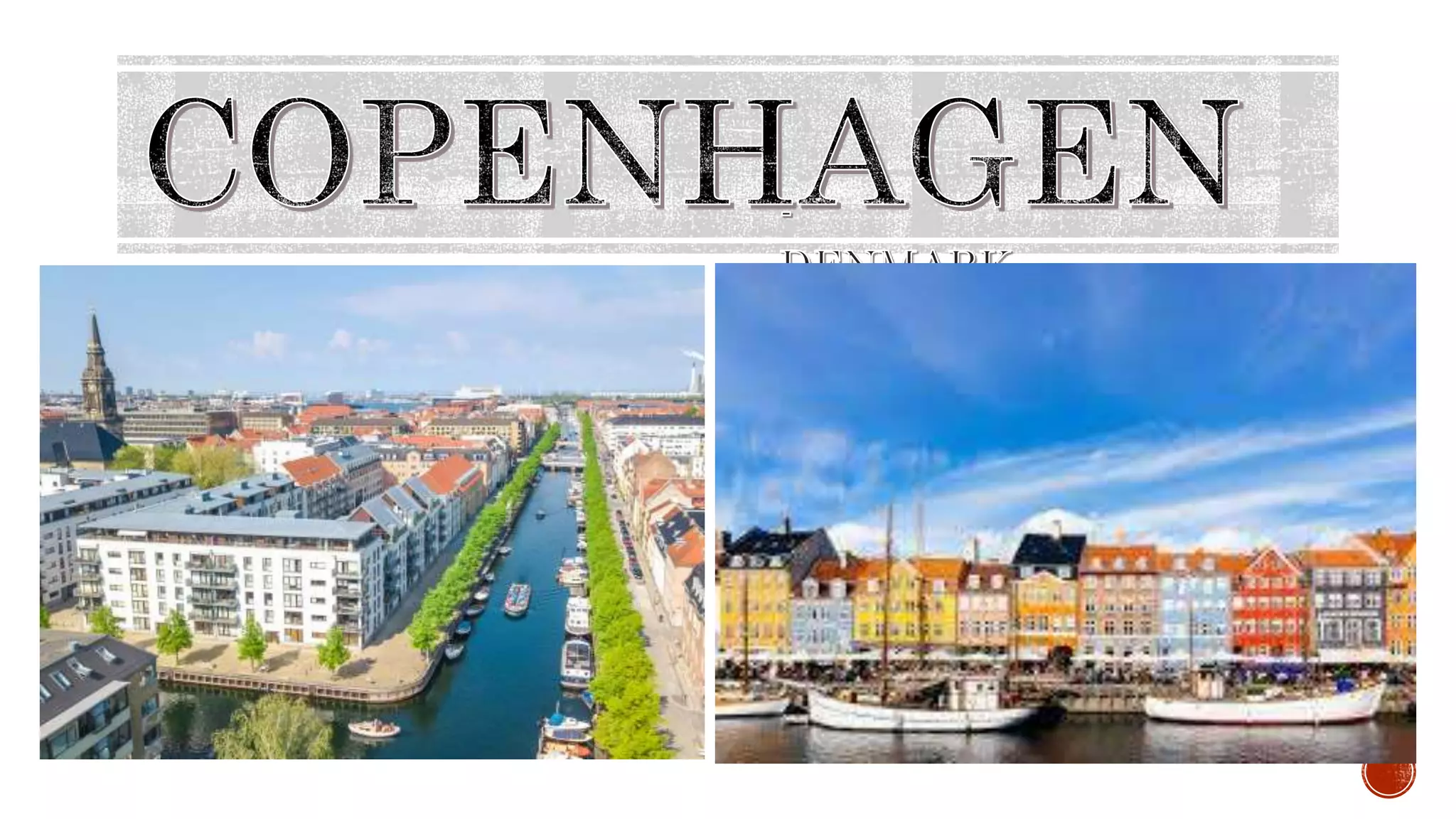
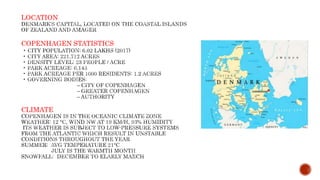
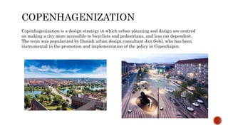
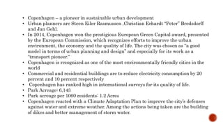
iginally a Viking fishing village founded in the 10th century then became the capital of Denmark in the early 15th century. Beginning in the 17th century it consolidated its position as a regional center of power with its institutions, defences and armed forces. After suffering from the effects of plague and fire in the 18th century, the city underwent a period of redevelopment. This included construction of the prestigious district of Frederiksstaden and founding of such cultural institutions as the Royal Theatre and the Royal Academy of Fine Arts. After further disasters in the early 19th century when Nelson attacked the Dano-Norwegian fleet and bombarded the city, rebuilding during the Danish Golden Age brought a Neoclassical look to Copenhagen's architecture. Later, following the Second World War, the Finger Plan fostered the development of housing and businesses along the five urban railway routes stretching out from the city centre.
Copenhagen – a pioneer in sustainable urban development
Urban planners are Steen Eiler Rasmussen ,Christian Erhardt “Peter” Bredsdorff and Jan Gehl.
In 2014, Copenhagen won the prestigious European Green Capital award, presented by the European Commission, which recognizes efforts to improve the urban environment, the economy and the quality of life. The city was chosen as “a good model in terms of urban planning and design” and especially for its work as a “transport pioneer.”
Copenhagen is recognized as one of the most environmentally friendly cities in the world
Commercial and residential buildings are to reduce electricity consumption by 20 percent and 10 percent respectively
Copenhagen has ranked high in international surveys for its quality of life.
Park Acreage: 6,143
Park acreage per 1000 residents: 1.2 Acres
Copenhagen reacted with a Climate Adaptation Plan to improve the city’s defenses against water and extreme weather. Among the actions being taken are the building of dikes and better management of storm water.
3. Originally a Viking fishing village founded in the 10th
century then became the capital of Denmark in the early
15th century. Beginning in the 17th century it
consolidated its position as a regional center of power
with its institutions, defences and armed forces. After
suffering from the effects of plague and fire in the 18th
century, the city underwent a period of redevelopment.
This included construction of the prestigious district of
Frederiksstaden and founding of such cultural
institutions as the Royal Theatre and the Royal Academy
of Fine Arts. After further disasters in the early 19th
century when Nelson attacked the Dano-Norwegian fleet
and bombarded the city, rebuilding during the Danish
Golden Age brought a Neoclassical look to Copenhagen's
architecture. Later, following the Second World War, the
Finger Plan fostered the development of housing and
businesses along the five urban railway routes stretching
out from the city centre.
4. COPENHAGENIZATION
Copenhagenization is a design strategy in which urban planning and design are centred
on making a city more accessible to bicyclists and pedestrians, and less car dependent.
The term was popularized by Danish urban design consultant Jan Gehl, who has been
instrumental in the promotion and implementation of the policy in Copenhagen.
5. • Copenhagen – a pioneer in sustainable urban development
• Urban planners are Steen Eiler Rasmussen ,Christian Erhardt “Peter” Bredsdorff
and Jan Gehl.
• In 2014, Copenhagen won the prestigious European Green Capital award, presented
by the European Commission, which recognizes efforts to improve the urban
environment, the economy and the quality of life. The city was chosen as “a good
model in terms of urban planning and design” and especially for its work as a
“transport pioneer.”
• Copenhagen is recognized as one of the most environmentally friendly cities in the
world
• Commercial and residential buildings are to reduce electricity consumption by 20
percent and 10 percent respectively
• Copenhagen has ranked high in international surveys for its quality of life.
• Park Acreage: 6,143
• Park acreage per 1000 residents: 1.2 Acres
• Copenhagen reacted with a Climate Adaptation Plan to improve the city’s defenses
against water and extreme weather. Among the actions being taken are the building
of dikes and better management of storm water.
7. 1: The medieval city
Until mid 19th century the city was surrounded by ramparts and 130,000 inhabitants
were living on just 3 Km2 in the fortifi ed city.
2: The Tram City
In the beginning of the 20th century Copenhagen incorporated some of its neighbouring
towns and the working and middle class areas that was developing there was subsequently
served by an extended network of trams.
3: The pre-WW2 city served by S-trains
In the 1930s the population of the capital passed one million making further layer-bylayer
growths impossible.
4: The post-WW2 radial, suburban development
The Fingerplan-city.
8.
9. In 1947, the Danish architects and town
planners Peter Bredsdorff and Sten Eiler
Rasmussen and their team presented a new
vision for the urban development of greater
Copenhagen The front page of the plan
visualised the future urban areas as a hand –
the palm resting on the existing compact city
centre, and the fingers pointing along future
cities, draped on infrastructural corridors that
radiated in five directions from the centre The
plan was logically nicknamed “The Finger
Plan”.
10. THE FIVE
FINGER PLAN
AND PUBLIC
TRANSPORTATI
ON
The Five Finger Plan, developed in 1947 through
Urban Planning Labratory in collaboration with urban
planners Steen Eiler Rasmussen and Christian
Erhardt “Peter” Bredsdorff, is an urban development
plan that focuses on both metropolitan train lines and
the green spaces in between. As you can see from the
graphic, the idea is that the train lines (s-tog) spread
like fingers on a hand from the “palm” of central
Copenhagen. At the time of it’s inception, the Five
Finger Plan did not go into Amager, which did not
have the infrastructure to support its inclusion. Now,
Amager is a much more developed area of Copenhagen
and is considered to be the “extra finger.”
The 170 km s-tog lines of the Five Finger Plan, along
with an extensive bus system, four lines of waterbuses
and a small but efficient metro (2002-2007), make up
Copenhagen’s city public transportation system.
11. 1. The public should have easy access to infrastructural facilities such as green spaces, bike paths, commuter
trains and motorways.
2. People should have the possibility to enjoy forests and lakes, agricultural landscapes, rivers, streams and
fjords and still benefit from the close proximity to the city centre.
3. The form of the Five Finger Plan makes traffic and transportation of people and goods a much easier task.
4. The Five Finger Plan has steered growth for almost 60 years
i) The Plan is still the basis of all regional planning - almost 60 years old. expecting
ii) growth of inhabitants >10.000 people/year in next 20 years.
iii) add 75,000 homes
iv) extend or thicken “fingers “– w/ same degree of infrastructural facilities. PRINCIPLES OF FINGER
PLANPRINCIPLES OF FINGER PLAN
12. CARS VS
BICYCLES
Widespread are cycles and cycle lanes
throughout the city that the term
“Copenhagenize” has come to meet adding
bicycle infrastructure to a city. In fact, when
New York City decided to make their city
more cycle-friendly, they hired Copenhagen
urban designer Jan Gehl.
Nearly 40% of people in Copenhagen cycle
daily, with that number expected to continue
rising. But it wasn’t always this way in
Copenhagen; if you see photos of the 20th
century, up until the late 1960’s, there were
cars everywhere.Copenhagen isn’t just an
example of how cycling infrastructure can
work, it’s an example of how fast it can be
adopted by a city and its people. Just try
imagining CPH without the bikes.
According to the Cycling Embassy of Denmark,
41% of all trips to work and study to/from
Copenhagen in 2017 were by bicycle and 62% of
Copenhageners chose to cycle to work and study
in Copenhagen. Copenhagen is targeting that
half of all its residents should cycle to work.
13. Everywhere you find spacious bike
lanes parallel to streets,
convenient cycle parking spaces,
and free-cycle repair shops. Quite
rightly, Copenhagen has been
ranked No. 1 as the most bicycle-
friendly city in the world.
The city was chosen as
“a good model in
terms of urban
planning and design”
and especially for its
work as a “transport
pioneer.”
Principle of providing people
accessibility rather than car
mobility, the city is also
famous for its cycling culture.
principle of providing people
accessibility rather than car
mobility, the city is also
famous for its cycling culture.
There is now an
extensive cycle
lane network of
about 411 km in
an area of about
90 km2.
15. Until 1962, all the streets and squares of central Copenhagen were
used intensively for vehicle traffic and parking and were under
pressure from the rapidly growing fleet of private vehicles.
The pedestrianization of Copenhagen began with the city’s main
street, Stroget, which was converted in 1962 as an experiment. The
conversion of the 1.15 km-long main street into a pedestrian street was
seen as a pioneering effort, which gave rise to much public debate
before the street was converted.
Soon, Stroget proved to be a huge success, with businesses realizing
that traffic-free environments provide increased financial revenue.
While there are a number of health advantages to walking, there are
additional benefits to having a walkable city: economically, shopping
areas that are pedestrian-accessible make sense because people can
easily get from store to store.
Infrastructure-wise, you don’t need to worry about parking, traffic, and
all the problems that must be addressed therein. Aesthetically, it’s
simply more beautiful.
BEFORE
AFTER
16. • Stroget has been renewed and upgraded several times during its 53 years as a pedestrian street, by
using progressively better-quality materials, repurposing public spaces and plazas to increase
pedestrian comfort, and adding outdoor uses.
17. According to the latest developments in Urban Design suggest
that all residences in a city should be no more than 300 meters
from a green space. This has lead to an interest in creating small
green spaces, rather than larger parks and open areas. While
these are often less popular with politicians, the intimate nature
of these spaces often means that they are used more frequently by
more people than big green spaces. Copenhagen’s urban design
has taken on the idea of creating urban gathering spaces all over
the city, including the now-world famous Superkilen by Bjarke
Ingels Group.
Scandinavia has been on the cutting edge of playground
development for years, moving away from conventional structures
and using more imagination-based play for children. The beloved
Rebskoven (Forest of Ropes) was created as part of a competition
to promote use of public space. Made up of 3,500 lengths of
vertical hanging rope, this temporary installation that moves
around the country is a magical and surreal playing experience for
children and adults alike.
18. • Copenhagen is a green city well endowed with open spaces. It has an extensive and well-distributed
system of parks that act as venues for a wide array of events and urban life. As a supplement to the
regular parks, there are a number of congenial public gardens and some cemeteries doubling as parks.
• They had a massive investments to reroute wastewater, build overflow-barriers, and create
underground water storage vessels, the water in the harbor is so clean that residents can enjoy a
swim. Mobile saunas at the riverside add to the pleasure. The city plans to add more public spaces
such as parks and community sport facilities to strengthen the urban social cohesion.
19. Copenhagen is expanding their public
transportation system. Specifically,
they’re expanding the metro by 17
stops with a circular line (that’s a big
jump for a metro that currently only
has 22 stops). Many places will see
huge accessibility improvements. In
the meantime, the construction sites
are being used for art exhibitions and
displays – a great way to utilize spaces
that would otherwise be eyesores.
20. The city sometimes referred to as
"the City of Spires", Copenhagen is
known for its horizontal skyline, broken
only by the spires and towers of its
churches and castles. Most
characteristic of all is the Baroque spire
of the Church of Our Saviour with its
narrowing external spiral stairway that
visitors can climb to the top. The city's
appearance today is shaped by the key
role it has played as a regional centre
for centuries. Copenhagen has a
multitude of districts, each with its
distinctive character and representing
its own period. Other distinctive
features of Copenhagen include the
abundance of water, its many parks,
and the bicycle paths that line most
streets.
21. Copenhagen has a large network of toll-free motorways and public roads connecting
different municipalities of the city together and to Northern Europe. As in many other cities
in Europe traffic is increasing . The radial arterial roads leading to Copenhagen city centre
are critically congested during peak hours. In October 2011, heated, political talks of plans
about road tolls around Copenhagen in order to combat the car congestion and improve the
air quality arose. Discussions were abandoned in February 2012 due to disagreement of the
physical locations of the toll road boundaries and political deadlock.
PUBLIC TRANSPORTATION OF
COPENHAGEN
S TRAINS AIRPORT HARBOUR
22. The S-train network is a metro like urban rapid transit
network mainly serving the urban Copenhagen area. It
connects the city centre and inner boroughs with the outer
boroughs of Copenhagen. As of January 2009 there are 170 km
of dual track and 84 S-train stations, of which eight are in
neighbouring towns outside greater Copenhagen. The system
has four main lines, and their tracks are fully separated from
all other traffic. Parts are underground, other parts elevated,
and some parts run in cuttings. Each line operates at a
frequency of six trains per hour throughout the day. Through
the city centre, however, where three of the four lines converge,
trains can be as often as every two or three minutes. The
fourth line, takes another path through the city and has an
operating frequency of 12 trains per hour. The S-Train system
is the main rail transport in Copenhagen. In the 1990s it was
decided to complement the S-Trains with a Metro system.
23. AIRPORT
Copenhagen Airport is the main airport serving Copenhagen. It is the largest in Scandinavia and the
17th largest in Europe. Located in Kastrup on the island of Amager, it has efficient connections to
downtown Copenhagen via metro and regional trains. Its location also makes it the most important
international airport for large parts of southern Sweden. Copenhagen Airport is a major hub for SAS
and Norwegian, and along with around 60 other airlines.
HARBOUR
Copenhagen has four lines of waterbuses, known as the Copenhagen Harbour Buses, serving ten
water bus stops The harbour of Copenhagen has largely lost its industrial importance. In 2001,
Copenhagen Harbour as an organisation merged with the harbour in Malmö to create Copenhagen-
Malmö Port. It has several functions, the most important being as a major cruise destination.