COPENHAGEN
CITY
ABSTRACT
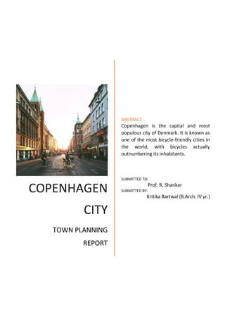
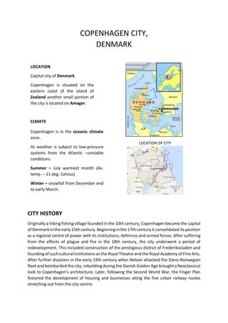
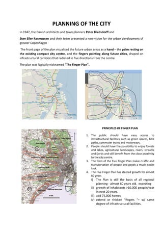
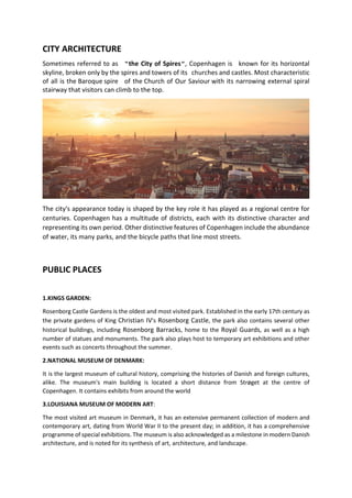
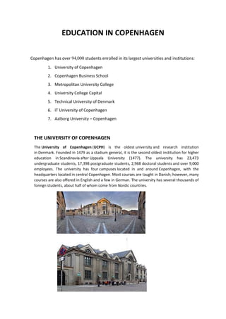
Copenhagen is the capital and most
populous city of Denmark. It is known as
one of the most bicycle-friendly cities in
the world, with bicycles actually
outnumbering its inhabitants.
SUBMITTED TO:
Prof. R. Shankar
SUBMITTED BY:
Kritika Bartwal (B.Arch. IV yr.)
TOWN PLANNING
REPORT
COPENHAGEN CITY,
DENMARK
LOCATION OF CITY
CITY HISTORY
Originally a Viking fishing village founded in the 10th century, Copenhagen became the capital
of Denmark in the early 15th century. Beginning in the 17th century it consolidated its position
as a regional centre of power with its institutions, defences and armed forces. After suffering
from the effects of plague and fire in the 18th century, the city underwent a period of
redevelopment. This included construction of the prestigious district of Frederiksstaden and
founding of such cultural institutions as the Royal Theatre and the Royal Academy of Fine Arts.
After further disasters in the early 19th century when Nelson attacked the Dano-Norwegian
fleet and bombarded the city, rebuilding during the Danish Golden Age brought a Neoclassical
look to Copenhagen's architecture. Later, following the Second World War, the Finger Plan
fostered the development of housing and businesses along the five urban railway routes
stretching out from the city centre.
LOCATION
Capital city of Denmark.
Copenhagen is situated on the
eastern coast of the island of
Zealand another small portion of
the city is located on Amager.
CLMATE
Copenhagen is in the oceanic climate
zone.
Its weather is subject to low-pressure
systems from the Atlantic –unstable
conditions.
Summer – July warmest month (Av.
temp. – 21 deg. Celsius)
Winter – snowfall from December end
to early March.
STREET SAFETY FOR BICYCLIST
COPENHAGENIZATION
Copenhagenization is a design strategy in which urban planning and design are centred on
making a city more accessible to bicyclists and pedestrians, and less car dependent.
The term was popularized by Danish urban design consultant Jan Gehl, who has been
instrumental in the promotion and implementation of the policy in Copenhagen.
NIGHT LIFE AND FESTIVALS
Copenhagen has one of the highest number of restaurants and bars per capita in the world.
The nightclubs and bars stay open until 5 or 6 in the morning, some even longer. Denmark
has a very liberal alcohol culture and a strong tradition for beer breweries, although binge
drinking is frowned upon and the Danish Police take driving under the influence very
seriously. Inner city areas such as Istedgade and Enghave Plads in Vesterbro, Sankt Hans Torv
in Nørrebro and certain places in Frederiksberg are especially noted for their nightlife.
COPENHAGEN STATISTICS
• City Population: 502,362 (2004)
• City Area: 221,712 acres
• Density Level: 23 people / acre
• Park Acreage: 6,143
• Park acreage per 1000 residents: 1.2
Acres
• Governing bodies:
– City of Copenhagen
– Greater Copenhagen
– Authority
PLANNING OF THE CITY
In 1947, the Danish architects and town planners Peter Bredsdorff and
Sten Eiler Rasmussen and their team presented a new vision for the urban development of
greater Copenhagen
The front page of the plan visualised the future urban areas as a hand – the palm resting on
the existing compact city centre, and the fingers pointing along future cities, draped on
infrastructural corridors that radiated in five directions from the centre
The plan was logically nicknamed “The Finger Plan”.
1. The public should have easy access to
infrastructural facilities such as green spaces, bike
paths, commuter trains and motorways.
2. People should have the possibility to enjoy forests
and lakes, agricultural landscapes, rivers, streams
and fjords and still benefit from the close proximity
to the city centre.
3. The form of the Five Finger Plan makes traffic and
transportation of people and goods a much easier
task.
4. The Five Finger Plan has steered growth for almost
60 years
i) The Plan is still the basis of all regional
planning - almost 60 years old. expecting
ii) growth of inhabitants >10.000 people/year
in next 20 years.
iii) add 75,000 homes
iv) extend or thicken “fingers “– w/ same
degree of infrastructural facilities.
PRINCIPLES OF FINGER PLANPRINCIPLES OF FINGER PLAN
FINGER PLAN ROAD NETWORK
LAND USE PLAN DISTRICT PLAN
MAP
CITY ARCHITECTURE
Sometimes referred to as "the City of Spires", Copenhagen is known for its horizontal
skyline, broken only by the spires and towers of its churches and castles. Most characteristic
of all is the Baroque spire of the Church of Our Saviour with its narrowing external spiral
stairway that visitors can climb to the top.
The city's appearance today is shaped by the key role it has played as a regional centre for
centuries. Copenhagen has a multitude of districts, each with its distinctive character and
representing its own period. Other distinctive features of Copenhagen include the abundance
of water, its many parks, and the bicycle paths that line most streets.
PUBLIC PLACES
1.KINGS GARDEN:
Rosenborg Castle Gardens is the oldest and most visited park. Established in the early 17th century as
the private gardens of King Christian IV's Rosenborg Castle, the park also contains several other
historical buildings, including Rosenborg Barracks, home to the Royal Guards, as well as a high
number of statues and monuments. The park also plays host to temporary art exhibitions and other
events such as concerts throughout the summer.
2.NATIONAL MUSEUM OF DENMARK:
It is the largest museum of cultural history, comprising the histories of Danish and foreign cultures,
alike. The museum's main building is located a short distance from Strøget at the centre of
Copenhagen. It contains exhibits from around the world
3.LOUISIANA MUSEUM OF MODERN ART:
The most visited art museum in Denmark, it has an extensive permanent collection of modern and
contemporary art, dating from World War II to the present day; in addition, it has a comprehensive
programme of special exhibitions. The museum is also acknowledged as a milestone in modern Danish
architecture, and is noted for its synthesis of art, architecture, and landscape.
TRANSPORTATION IN COPENHAGEN
ROAD NETWORK
Copenhagen has a large network of toll-free motorways and public roads connecting different
municipalities of the city together and to Northern Europe. As in many other cities in Europe
traffic is increasing in Copenhagen. The radial arterial roads leading to Copenhagen city centre
are critically congested during peak hours.
In October 2011, heated, political talks of plans about road tolls around Copenhagen in order
to combat the car congestion and improve the air quality arose. Discussions were abandoned
in February 2012 due to disagreement of the physical locations of the toll road boundaries
and political deadlock.
ROAD MAP BICYCLING TRACK
BICYCLING TRACKS
Copenhagen is known as one of the most bicycle-friendly cities in the world. Every day
1.1 million km are bicycled in Copenhagen.
The city's bicycle paths and cycle tracks are extensive and well used. Bicycle paths are often
separated from the main traffic lanes and sometimes have their own signal systems, giving
the cyclists a lead of a couple of seconds to accelerate.
The municipality is also developing a system of interconnected green bicycle
routes, greenways, the aim being to facilitate fast, safe, and pleasant bicycle transport from
one end of the city to the other. The network will cover more than 100 km (62 mi) and will
have 22 routes when finished. The city provides public bicycles which can be found
throughout the downtown area.
PUBLIC BICYCLES: The bicycle sharing system was launched in 1995 with 1,000 cycles, the project was
the world's first organized large-scale urban bike-sharing scheme, featured what are now considered
basic elements such as coin deposit, fixed stands and specially designed bikes with parts that cannot
be used on other bikes.
PUBLIC TRANSPORTATION
S-TRAIN
S-TRAIN CHART
(COPENHAGEN)
AIRPORT
Copenhagen Airport is the main airport serving Copenhagen. It is the largest
in Scandinavia and the 17th largest in Europe. Located in Kastrup on the island of Amager, it
has efficient connections to downtown Copenhagen via metro and regional trains. Its location
also makes it the most important international airport for large parts of southern Sweden.
Copenhagen Airport is a major hub for SAS and Norwegian, and along with around 60 other
airlines.
HARBOUR
Copenhagen has four lines of waterbuses, known as the Copenhagen Harbour Buses, serving
ten water bus stops
The harbour of Copenhagen has largely lost its industrial importance. In 2001, Copenhagen
Harbour as an organisation merged with the harbour in Malmö to create Copenhagen-Malmö
Port. It has several functions, the most important being as a major cruise destination.
The S-train network is a metro like urban rapid
transit network mainly serving the urban
Copenhagen area. It connects the city centre
and inner boroughs with the outer boroughs of
Copenhagen. As of January 2009 there are
170 km of dual track and 84 S-train stations, of
which eight are in neighbouring towns outside
greater Copenhagen. The system has four main
lines, and their tracks are fully separated from
all other traffic. Parts are underground, other
parts elevated, and some parts run in cuttings.
Each line operates at a frequency of six trains
per hour throughout the day. Through the city
centre, however, where three of the four lines
converge, trains can be as often as every two or
three minutes. The fourth line, takes another
path through the city and has an operating
frequency of 12 trains per hour. The S-Train
system is the main rail transport in Copenhagen.
In the 1990s it was decided to complement the
S-Trains with a Metro system.
EDUCATION IN COPENHAGEN
Copenhagen has over 94,000 students enrolled in its largest universities and institutions:
1. University of Copenhagen
2. Copenhagen Business School
3. Metropolitan University College
4. University College Capital
5. Technical University of Denmark
6. IT University of Copenhagen
7. Aalborg University – Copenhagen
THE UNIVERSITY OF COPENHAGEN
The University of Copenhagen (UCPH) is the oldest university and research institution
in Denmark. Founded in 1479 as a stadium general, it is the second oldest institution for higher
education in Scandinavia after Uppsala University (1477). The university has 23,473
undergraduate students, 17,398 postgraduate students, 2,968 doctoral students and over 9,000
employees. The university has four campuses located in and around Copenhagen, with the
headquarters located in central Copenhagen. Most courses are taught in Danish; however, many
courses are also offered in English and a few in German. The university has several thousands of
foreign students, about half of whom come from Nordic countries.

Copenhagen city

  • 1.
    COPENHAGEN CITY ABSTRACT Copenhagen is thecapital and most populous city of Denmark. It is known as one of the most bicycle-friendly cities in the world, with bicycles actually outnumbering its inhabitants. SUBMITTED TO: Prof. R. Shankar SUBMITTED BY: Kritika Bartwal (B.Arch. IV yr.) TOWN PLANNING REPORT
  • 2.
    COPENHAGEN CITY, DENMARK LOCATION OFCITY CITY HISTORY Originally a Viking fishing village founded in the 10th century, Copenhagen became the capital of Denmark in the early 15th century. Beginning in the 17th century it consolidated its position as a regional centre of power with its institutions, defences and armed forces. After suffering from the effects of plague and fire in the 18th century, the city underwent a period of redevelopment. This included construction of the prestigious district of Frederiksstaden and founding of such cultural institutions as the Royal Theatre and the Royal Academy of Fine Arts. After further disasters in the early 19th century when Nelson attacked the Dano-Norwegian fleet and bombarded the city, rebuilding during the Danish Golden Age brought a Neoclassical look to Copenhagen's architecture. Later, following the Second World War, the Finger Plan fostered the development of housing and businesses along the five urban railway routes stretching out from the city centre. LOCATION Capital city of Denmark. Copenhagen is situated on the eastern coast of the island of Zealand another small portion of the city is located on Amager. CLMATE Copenhagen is in the oceanic climate zone. Its weather is subject to low-pressure systems from the Atlantic –unstable conditions. Summer – July warmest month (Av. temp. – 21 deg. Celsius) Winter – snowfall from December end to early March.
  • 3.
    STREET SAFETY FORBICYCLIST COPENHAGENIZATION Copenhagenization is a design strategy in which urban planning and design are centred on making a city more accessible to bicyclists and pedestrians, and less car dependent. The term was popularized by Danish urban design consultant Jan Gehl, who has been instrumental in the promotion and implementation of the policy in Copenhagen. NIGHT LIFE AND FESTIVALS Copenhagen has one of the highest number of restaurants and bars per capita in the world. The nightclubs and bars stay open until 5 or 6 in the morning, some even longer. Denmark has a very liberal alcohol culture and a strong tradition for beer breweries, although binge drinking is frowned upon and the Danish Police take driving under the influence very seriously. Inner city areas such as Istedgade and Enghave Plads in Vesterbro, Sankt Hans Torv in Nørrebro and certain places in Frederiksberg are especially noted for their nightlife. COPENHAGEN STATISTICS • City Population: 502,362 (2004) • City Area: 221,712 acres • Density Level: 23 people / acre • Park Acreage: 6,143 • Park acreage per 1000 residents: 1.2 Acres • Governing bodies: – City of Copenhagen – Greater Copenhagen – Authority
  • 4.
    PLANNING OF THECITY In 1947, the Danish architects and town planners Peter Bredsdorff and Sten Eiler Rasmussen and their team presented a new vision for the urban development of greater Copenhagen The front page of the plan visualised the future urban areas as a hand – the palm resting on the existing compact city centre, and the fingers pointing along future cities, draped on infrastructural corridors that radiated in five directions from the centre The plan was logically nicknamed “The Finger Plan”. 1. The public should have easy access to infrastructural facilities such as green spaces, bike paths, commuter trains and motorways. 2. People should have the possibility to enjoy forests and lakes, agricultural landscapes, rivers, streams and fjords and still benefit from the close proximity to the city centre. 3. The form of the Five Finger Plan makes traffic and transportation of people and goods a much easier task. 4. The Five Finger Plan has steered growth for almost 60 years i) The Plan is still the basis of all regional planning - almost 60 years old. expecting ii) growth of inhabitants >10.000 people/year in next 20 years. iii) add 75,000 homes iv) extend or thicken “fingers “– w/ same degree of infrastructural facilities. PRINCIPLES OF FINGER PLANPRINCIPLES OF FINGER PLAN
  • 5.
    FINGER PLAN ROADNETWORK LAND USE PLAN DISTRICT PLAN MAP
  • 6.
    CITY ARCHITECTURE Sometimes referredto as "the City of Spires", Copenhagen is known for its horizontal skyline, broken only by the spires and towers of its churches and castles. Most characteristic of all is the Baroque spire of the Church of Our Saviour with its narrowing external spiral stairway that visitors can climb to the top. The city's appearance today is shaped by the key role it has played as a regional centre for centuries. Copenhagen has a multitude of districts, each with its distinctive character and representing its own period. Other distinctive features of Copenhagen include the abundance of water, its many parks, and the bicycle paths that line most streets. PUBLIC PLACES 1.KINGS GARDEN: Rosenborg Castle Gardens is the oldest and most visited park. Established in the early 17th century as the private gardens of King Christian IV's Rosenborg Castle, the park also contains several other historical buildings, including Rosenborg Barracks, home to the Royal Guards, as well as a high number of statues and monuments. The park also plays host to temporary art exhibitions and other events such as concerts throughout the summer. 2.NATIONAL MUSEUM OF DENMARK: It is the largest museum of cultural history, comprising the histories of Danish and foreign cultures, alike. The museum's main building is located a short distance from Strøget at the centre of Copenhagen. It contains exhibits from around the world 3.LOUISIANA MUSEUM OF MODERN ART: The most visited art museum in Denmark, it has an extensive permanent collection of modern and contemporary art, dating from World War II to the present day; in addition, it has a comprehensive programme of special exhibitions. The museum is also acknowledged as a milestone in modern Danish architecture, and is noted for its synthesis of art, architecture, and landscape.
  • 7.
    TRANSPORTATION IN COPENHAGEN ROADNETWORK Copenhagen has a large network of toll-free motorways and public roads connecting different municipalities of the city together and to Northern Europe. As in many other cities in Europe traffic is increasing in Copenhagen. The radial arterial roads leading to Copenhagen city centre are critically congested during peak hours. In October 2011, heated, political talks of plans about road tolls around Copenhagen in order to combat the car congestion and improve the air quality arose. Discussions were abandoned in February 2012 due to disagreement of the physical locations of the toll road boundaries and political deadlock. ROAD MAP BICYCLING TRACK BICYCLING TRACKS Copenhagen is known as one of the most bicycle-friendly cities in the world. Every day 1.1 million km are bicycled in Copenhagen. The city's bicycle paths and cycle tracks are extensive and well used. Bicycle paths are often separated from the main traffic lanes and sometimes have their own signal systems, giving the cyclists a lead of a couple of seconds to accelerate. The municipality is also developing a system of interconnected green bicycle routes, greenways, the aim being to facilitate fast, safe, and pleasant bicycle transport from one end of the city to the other. The network will cover more than 100 km (62 mi) and will have 22 routes when finished. The city provides public bicycles which can be found throughout the downtown area. PUBLIC BICYCLES: The bicycle sharing system was launched in 1995 with 1,000 cycles, the project was the world's first organized large-scale urban bike-sharing scheme, featured what are now considered basic elements such as coin deposit, fixed stands and specially designed bikes with parts that cannot be used on other bikes.
  • 8.
    PUBLIC TRANSPORTATION S-TRAIN S-TRAIN CHART (COPENHAGEN) AIRPORT CopenhagenAirport is the main airport serving Copenhagen. It is the largest in Scandinavia and the 17th largest in Europe. Located in Kastrup on the island of Amager, it has efficient connections to downtown Copenhagen via metro and regional trains. Its location also makes it the most important international airport for large parts of southern Sweden. Copenhagen Airport is a major hub for SAS and Norwegian, and along with around 60 other airlines. HARBOUR Copenhagen has four lines of waterbuses, known as the Copenhagen Harbour Buses, serving ten water bus stops The harbour of Copenhagen has largely lost its industrial importance. In 2001, Copenhagen Harbour as an organisation merged with the harbour in Malmö to create Copenhagen-Malmö Port. It has several functions, the most important being as a major cruise destination. The S-train network is a metro like urban rapid transit network mainly serving the urban Copenhagen area. It connects the city centre and inner boroughs with the outer boroughs of Copenhagen. As of January 2009 there are 170 km of dual track and 84 S-train stations, of which eight are in neighbouring towns outside greater Copenhagen. The system has four main lines, and their tracks are fully separated from all other traffic. Parts are underground, other parts elevated, and some parts run in cuttings. Each line operates at a frequency of six trains per hour throughout the day. Through the city centre, however, where three of the four lines converge, trains can be as often as every two or three minutes. The fourth line, takes another path through the city and has an operating frequency of 12 trains per hour. The S-Train system is the main rail transport in Copenhagen. In the 1990s it was decided to complement the S-Trains with a Metro system.
  • 9.
    EDUCATION IN COPENHAGEN Copenhagenhas over 94,000 students enrolled in its largest universities and institutions: 1. University of Copenhagen 2. Copenhagen Business School 3. Metropolitan University College 4. University College Capital 5. Technical University of Denmark 6. IT University of Copenhagen 7. Aalborg University – Copenhagen THE UNIVERSITY OF COPENHAGEN The University of Copenhagen (UCPH) is the oldest university and research institution in Denmark. Founded in 1479 as a stadium general, it is the second oldest institution for higher education in Scandinavia after Uppsala University (1477). The university has 23,473 undergraduate students, 17,398 postgraduate students, 2,968 doctoral students and over 9,000 employees. The university has four campuses located in and around Copenhagen, with the headquarters located in central Copenhagen. Most courses are taught in Danish; however, many courses are also offered in English and a few in German. The university has several thousands of foreign students, about half of whom come from Nordic countries.