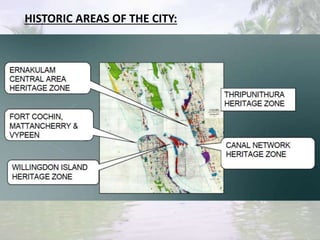
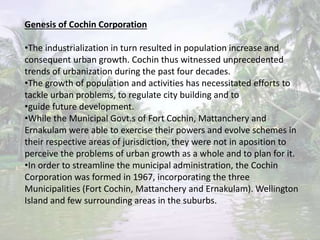
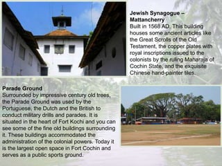
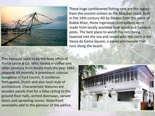
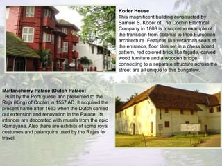
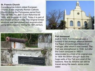
VERNACULAR ARCHITECTURE
PLANNING OF COCHIN CITY
Cochin – Biggest urban
conglomeration in Kerala.
Location – 9deg 55’ N & 76deg 15’
East.
Characteristic physical feature –
expanse of backwaters and low
lying wetlands.
Typical soil strata – alluvial soil
laden with fine silt & clay to depths
up to 50m.
Hot humid climate with max. temp
of 34 deg & min of 22 deg.
Average annual rain fall – 3000 mm
from two monsoons.
Relative Humidity – 70 – 87 %
LOCATION, GEOGRAPHIC AND CLIMATIC CONDITIONS:
IMAGE OF PORT OF COCHIN
HISTORIC AREAS OF THE CITY:
Early History:
•Cochin Port was formed in 1341, when the heavy floods of that
year silted up the mouths of the Musiris harbor and the surging
waters forced a channel past the present inlet into the sea. The old
merchants of Musiris shifted to Cochin as soon as the new outlet
became more or less stable.
•As the harbour gained prominence, the then ruler of the region
shifted his capital also to Cochin, giving impetus to the growth of
the town.
•The early settlement of Cochin was at Mattanchery, facing the
protected lagoons in the east, which provided safe anchorage to
country crafts in all seasons. Mattanchery was linked to the entire
coastal stretch of Kerala through this inland waters. Thus gradually
it grew into a busy settlement.
•Nicolo Conti recorded that, by 1440, Cochin was a city 5 miles in
circumference and that Chinese and Arabs carried on brisk trade
with the natives of this town.
Colonial settlement in Fort Cochin:
•From 16th Century, Cochin witnessed the rapid changes through
the trading and colonizing attempts of European powers.
Portuguese were the first to arrive in Cochin. They founded Fort
Cochin
•established factories and warehouses, schools and hospitals and
extended their domain in the political and religious fronts. The fall
of the Portuguese in Cochin came with take over of the Fort by
Dutch in 1663.
•The Dutch East India Company tried to persuade the local rulers
into giving them monopoly in pepper trade. In this attempt, they
came across varied interests of other forces viz. English, French and
the Dutch.
•For hundred years therefore Cochin became the center of political
and commercial battle. In 1795, The British took over Cochin from
the Dutch. Fort Cochin thus became British Cochin. It became a
•Municipality in 1866.
Maps–showinggrowthof
settlementsinCochin
Market Town- Mattanchery
•Mattanchery, meanwhile, had developed as a typical oriental market town, with
commercial
•activities distributed along the waterfronts.
•The agricultural produce from the vast hinterland flowed to its markets to be sold or
exchanged for textiles, metals, and other products of European Countries. Jews and
Muslims had their settlements here.
•The trading communities from Gujarat and the emigrants from Goa too established
themselves in Mattanchery along with the native Hindus and early Christians. As far as
the rulers were concerned, this helped to strike a balance of economic power with the
European traders.
Administrative Centre – Ernakulam
•By 1840, Mattanchery was so much crowded that the Cochin rulers shifted their
capital to
•Ernakulam on the eastern side of the backwaters. Public buildings and educational
institutions were set up in Ernakulam befitting the splendor of Maharajas. Roads were
laid out. Markets were established. Temples were renovated.
• Railways came to Ernakulam in 1905. Ernakulam thus gradually started developing as
an administrative town. Mattanchery rose to the status of Municipality in 1912 and
was followed by Ernakulam in 1913.
Development of Cochin Port
•In those decades the existence of a sand bar in the sea mouth prevented large ships from
entering safely into the backwaters of Cochin. With industrialization in the west there
came the revolution in overseas trade with the wrought iron ships of greater draught and
the consequent need for deeper and safer harbours and stronger moorings. The opening
of Suez Canal in 1869 further emphasized the importance of this port as a coaling station
for this route. The idea of making great harbour, out of the unique lagoons in
•Cochin was thus originated as early as 1870. But Cochin presented a case for dredged
channel leading to the inland harbour, unfortunately the science and art of dredging was
not fully developed in this period.
•Hence it was only in 1920 that the port works were initiated. Under the direction of Sir
Robert Bristo, the sand bar at sea mouth was cut open and a deep shipping channel was
dredged to the backwaters.
• The spoils of the dredging was used to the reclaim Wellington Island from the
backwaters. Road connection to the main land on the west and road-rail connection to the
east from the island was completed in 1940 when Cochin was declared as a major port by
the Government of India. Wellington Island developed with its
wharfs, quays and other infrastructure as terminal complex of transportation.
•Cochin port gradually became the focus of the city. Centered around the port facility grew
large number of business and commercial establishments providing the economic base to
the city and the environs.
Genesis of Cochin Corporation
•The industrialization in turn resulted in population increase and
consequent urban growth. Cochin thus witnessed unprecedented
trends of urbanization during the past four decades.
•The growth of population and activities has necessitated efforts to
tackle urban problems, to regulate city building and to
•guide future development.
•While the Municipal Govt.s of Fort Cochin, Mattanchery and
Ernakulam were able to exercise their powers and evolve schemes in
their respective areas of jurisdiction, they were not in aposition to
perceive the problems of urban growth as a whole and to plan for it.
•In order to streamline the municipal administration, the Cochin
Corporation was formed in 1967, incorporating the three
Municipalities (Fort Cochin, Mattanchery and Ernakulam). Wellington
Island and few surrounding areas in the suburbs.
Jewish Synagogue –
Mattancherry
Built in 1568 AD. This building
houses some ancient articles like
the Great Scrolls of the Old
Testament, the copper plates with
royal inscriptions issued to the
colonists by the ruling Maharaja of
Cochin State, and the exquisite
Chinese hand-painter tiles.
Parade Ground
Surrounded by impressive century old trees,
the Parade Ground was used by the
Portuguese, the Dutch and the British to
conduct military drills and parades. It is
situated in the heart of Fort Kochi and you can
see some of the fine old buildings surrounding
it. These buildings accommodated the
administration of the colonial powers. Today it
is the largest open space in Fort Cochin and
serves as a public sports ground.
These huge cantilevered fishing nets are the legacy
from the ancient visitors to the Malabar coast. Built
in the 14th century AD by traders from the court of
Kublai Khan, these ingenious contraptions were
made from locally available teak wood and bamboo
poles. The best place to watch the nets being
lowered into the sea and raised with the catch is the
Vasco da Gama Square, a paved promenade that
runs along the beach.
This mansion used to be the busy office of
Pierce Leslie & Co. Who traded in coffee and
other produce from Kerala from the year 1862
onwards till recently. A prominent colonial
bungalow in Fort Cochin, it combines
Portuguese, Dutch and also local style of
architecture. Characteristic features are
wooden panels that for a false ceiling to the
ground floor halls, arched doorways, carved
doors and sprawling rooms. Waterfront
verandahs add to the glamour of the edifice.
Koder House
This magnificent building constructed by
Samuel S. Koder of The Cochin Electrical
Company in 1808 is a supreme example of
the transition from colonial to Indo European
architecture. Features like verandah seats at
the entrance, floor tiles set in a chess board
pattern, red colored brick like façade, carved
wood furniture and a wooden bridge
connecting to a separate structure across the
street are all unique to this bungalow.
Mattancherry Palace (Dutch Palace)
Built by the Portuguese and presented to the
Raja (King) of Cochin in 1557 AD, it acquired the
present name after 1663 when the Dutch carried
out extension and renovation in the Palace. Its
interiors are decorated with murals from the epic
Ramayana. Also there are exhibits of some royal
costumes and palanquins used by the Rajas for
travel.
Indo-Portuguese Museum / Bishop’s House
Standing on a gentle hillock near the Parade Ground, the Bishop’s House boasts a facade
having large gothic arches. Originally build in 1506 AD for the residence of the Portuguese
Governor; it was the turn of the Dutch to occupy it from 1663 AD. After the British conquest
in 1795 the property came into the possession of the Vernedes family. From them it moved
into the hands of Dom Jose Gomes Ferreira, the 27th Bishop of Cochin, whose jurisdiction
extended over to Burma, Malaya and Ceylon, in addition to the whole of Southern and
Eastern India.
Today, a Museum depicting Indo-Portuguese history is functioning in a newly built hall.
St. Francis Church
Considered as India’s oldest European
Church, it was originally Roman Catholic
Church during the Portuguese period from
1503 till 1663 Ad, then Dutch Reformist till
1804, and Anglican till 1947. Today it is part of
the Church of South India. The Original timber
structure was demolished and reconstructed
using stone masonry during the 16th century.
Fort Immanuel
Built in 1503, Fort Immanuel was a
symbol of the strategic alliance between
the Rajah of Cochin and Monarch of
Portugal, after whom it was named. The
Fort was strengthened in 1538, but after
the Dutch conquest in 1663 it
deteriorated to a third of its original size.
In 1806 the British brought down the
huge walls of the Fort and most of the
bastions. Now its remains can still be
traced along the beach, some under
water.

Cochin vernacular architecture

  • 1.
  • 2.
    Cochin – Biggesturban conglomeration in Kerala. Location – 9deg 55’ N & 76deg 15’ East. Characteristic physical feature – expanse of backwaters and low lying wetlands. Typical soil strata – alluvial soil laden with fine silt & clay to depths up to 50m. Hot humid climate with max. temp of 34 deg & min of 22 deg. Average annual rain fall – 3000 mm from two monsoons. Relative Humidity – 70 – 87 % LOCATION, GEOGRAPHIC AND CLIMATIC CONDITIONS:
  • 3.
    IMAGE OF PORTOF COCHIN
  • 4.
  • 5.
    Early History: •Cochin Portwas formed in 1341, when the heavy floods of that year silted up the mouths of the Musiris harbor and the surging waters forced a channel past the present inlet into the sea. The old merchants of Musiris shifted to Cochin as soon as the new outlet became more or less stable. •As the harbour gained prominence, the then ruler of the region shifted his capital also to Cochin, giving impetus to the growth of the town. •The early settlement of Cochin was at Mattanchery, facing the protected lagoons in the east, which provided safe anchorage to country crafts in all seasons. Mattanchery was linked to the entire coastal stretch of Kerala through this inland waters. Thus gradually it grew into a busy settlement. •Nicolo Conti recorded that, by 1440, Cochin was a city 5 miles in circumference and that Chinese and Arabs carried on brisk trade with the natives of this town.
  • 6.
    Colonial settlement inFort Cochin: •From 16th Century, Cochin witnessed the rapid changes through the trading and colonizing attempts of European powers. Portuguese were the first to arrive in Cochin. They founded Fort Cochin •established factories and warehouses, schools and hospitals and extended their domain in the political and religious fronts. The fall of the Portuguese in Cochin came with take over of the Fort by Dutch in 1663. •The Dutch East India Company tried to persuade the local rulers into giving them monopoly in pepper trade. In this attempt, they came across varied interests of other forces viz. English, French and the Dutch. •For hundred years therefore Cochin became the center of political and commercial battle. In 1795, The British took over Cochin from the Dutch. Fort Cochin thus became British Cochin. It became a •Municipality in 1866.
  • 7.
  • 8.
    Market Town- Mattanchery •Mattanchery,meanwhile, had developed as a typical oriental market town, with commercial •activities distributed along the waterfronts. •The agricultural produce from the vast hinterland flowed to its markets to be sold or exchanged for textiles, metals, and other products of European Countries. Jews and Muslims had their settlements here. •The trading communities from Gujarat and the emigrants from Goa too established themselves in Mattanchery along with the native Hindus and early Christians. As far as the rulers were concerned, this helped to strike a balance of economic power with the European traders. Administrative Centre – Ernakulam •By 1840, Mattanchery was so much crowded that the Cochin rulers shifted their capital to •Ernakulam on the eastern side of the backwaters. Public buildings and educational institutions were set up in Ernakulam befitting the splendor of Maharajas. Roads were laid out. Markets were established. Temples were renovated. • Railways came to Ernakulam in 1905. Ernakulam thus gradually started developing as an administrative town. Mattanchery rose to the status of Municipality in 1912 and was followed by Ernakulam in 1913.
  • 9.
    Development of CochinPort •In those decades the existence of a sand bar in the sea mouth prevented large ships from entering safely into the backwaters of Cochin. With industrialization in the west there came the revolution in overseas trade with the wrought iron ships of greater draught and the consequent need for deeper and safer harbours and stronger moorings. The opening of Suez Canal in 1869 further emphasized the importance of this port as a coaling station for this route. The idea of making great harbour, out of the unique lagoons in •Cochin was thus originated as early as 1870. But Cochin presented a case for dredged channel leading to the inland harbour, unfortunately the science and art of dredging was not fully developed in this period. •Hence it was only in 1920 that the port works were initiated. Under the direction of Sir Robert Bristo, the sand bar at sea mouth was cut open and a deep shipping channel was dredged to the backwaters. • The spoils of the dredging was used to the reclaim Wellington Island from the backwaters. Road connection to the main land on the west and road-rail connection to the east from the island was completed in 1940 when Cochin was declared as a major port by the Government of India. Wellington Island developed with its wharfs, quays and other infrastructure as terminal complex of transportation. •Cochin port gradually became the focus of the city. Centered around the port facility grew large number of business and commercial establishments providing the economic base to the city and the environs.
  • 10.
    Genesis of CochinCorporation •The industrialization in turn resulted in population increase and consequent urban growth. Cochin thus witnessed unprecedented trends of urbanization during the past four decades. •The growth of population and activities has necessitated efforts to tackle urban problems, to regulate city building and to •guide future development. •While the Municipal Govt.s of Fort Cochin, Mattanchery and Ernakulam were able to exercise their powers and evolve schemes in their respective areas of jurisdiction, they were not in aposition to perceive the problems of urban growth as a whole and to plan for it. •In order to streamline the municipal administration, the Cochin Corporation was formed in 1967, incorporating the three Municipalities (Fort Cochin, Mattanchery and Ernakulam). Wellington Island and few surrounding areas in the suburbs.
  • 11.
    Jewish Synagogue – Mattancherry Builtin 1568 AD. This building houses some ancient articles like the Great Scrolls of the Old Testament, the copper plates with royal inscriptions issued to the colonists by the ruling Maharaja of Cochin State, and the exquisite Chinese hand-painter tiles. Parade Ground Surrounded by impressive century old trees, the Parade Ground was used by the Portuguese, the Dutch and the British to conduct military drills and parades. It is situated in the heart of Fort Kochi and you can see some of the fine old buildings surrounding it. These buildings accommodated the administration of the colonial powers. Today it is the largest open space in Fort Cochin and serves as a public sports ground.
  • 12.
    These huge cantileveredfishing nets are the legacy from the ancient visitors to the Malabar coast. Built in the 14th century AD by traders from the court of Kublai Khan, these ingenious contraptions were made from locally available teak wood and bamboo poles. The best place to watch the nets being lowered into the sea and raised with the catch is the Vasco da Gama Square, a paved promenade that runs along the beach. This mansion used to be the busy office of Pierce Leslie & Co. Who traded in coffee and other produce from Kerala from the year 1862 onwards till recently. A prominent colonial bungalow in Fort Cochin, it combines Portuguese, Dutch and also local style of architecture. Characteristic features are wooden panels that for a false ceiling to the ground floor halls, arched doorways, carved doors and sprawling rooms. Waterfront verandahs add to the glamour of the edifice.
  • 13.
    Koder House This magnificentbuilding constructed by Samuel S. Koder of The Cochin Electrical Company in 1808 is a supreme example of the transition from colonial to Indo European architecture. Features like verandah seats at the entrance, floor tiles set in a chess board pattern, red colored brick like façade, carved wood furniture and a wooden bridge connecting to a separate structure across the street are all unique to this bungalow. Mattancherry Palace (Dutch Palace) Built by the Portuguese and presented to the Raja (King) of Cochin in 1557 AD, it acquired the present name after 1663 when the Dutch carried out extension and renovation in the Palace. Its interiors are decorated with murals from the epic Ramayana. Also there are exhibits of some royal costumes and palanquins used by the Rajas for travel.
  • 14.
    Indo-Portuguese Museum /Bishop’s House Standing on a gentle hillock near the Parade Ground, the Bishop’s House boasts a facade having large gothic arches. Originally build in 1506 AD for the residence of the Portuguese Governor; it was the turn of the Dutch to occupy it from 1663 AD. After the British conquest in 1795 the property came into the possession of the Vernedes family. From them it moved into the hands of Dom Jose Gomes Ferreira, the 27th Bishop of Cochin, whose jurisdiction extended over to Burma, Malaya and Ceylon, in addition to the whole of Southern and Eastern India. Today, a Museum depicting Indo-Portuguese history is functioning in a newly built hall.
  • 15.
    St. Francis Church Consideredas India’s oldest European Church, it was originally Roman Catholic Church during the Portuguese period from 1503 till 1663 Ad, then Dutch Reformist till 1804, and Anglican till 1947. Today it is part of the Church of South India. The Original timber structure was demolished and reconstructed using stone masonry during the 16th century. Fort Immanuel Built in 1503, Fort Immanuel was a symbol of the strategic alliance between the Rajah of Cochin and Monarch of Portugal, after whom it was named. The Fort was strengthened in 1538, but after the Dutch conquest in 1663 it deteriorated to a third of its original size. In 1806 the British brought down the huge walls of the Fort and most of the bastions. Now its remains can still be traced along the beach, some under water.