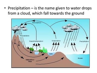
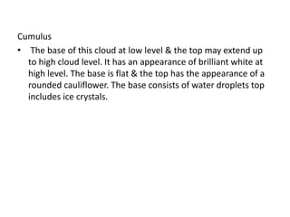
2. 4.3.1 Hydrological cycle
i. Explains the Hydrological cycle on the earth
• Evaporation – is the transformation of water into water
vapor. During evaporation, latent heat is absorbed from
the surrounding air and from the water surface.
• Condensation – is the transformation of water-vapor
into water. During condensation, latent heat is given off
to the surrounding air. It occurs if air is cooled below its
dew point.
This cooling is usually the result of;
• 1. Contact with cold surface of land or sea.
• 2. Adiabatic cooling when air rises.
• 3. Contact with the colder masses of air.
• 4. Radiation of heat into space from upper layers of air.
3. • Precipitation – is the name given to water drops
from a cloud, which fall towards the ground
4. 4.3.2 Formation of Clouds
i. Defines the clouds
• Clouds are defined as minute particles of water, Ice
crystals or both hanging in the atmosphere above
the ground level.
When air is cooled below its Dew point due to
• 1. Adiabatic cooling during ascent or
• 2. Contact with cold air mass or
• 3. Contact with cold surface of land or sea.
• 4. Radiation of heat into space by upper layers of air.
The excess water vapor condense into minute particles
of water which remains suspended in air. When
millions of such particles are close together visible as a
cloud.
5. ii. Explain the content of a cloud
• The liquid water content of clouds is usually given
in units of mass of liquid per volume of air
(gm−3).
• The liquid water content varies geographically,
and also with the type of cloud.
• Clouds contain hydrocarbons and all manner of
organic chemicals. Plus, as we all know, clouds
can carry tremendous electrical charges.
6. iii. Describe cloud formation.
• Note is available under 4.2.7 – V
iv. Classifies the clouds according to height and
appearance
• Clouds are grouped according to their heights;
• Low Clouds- consist entirely of water droplets and
have bases between 0km-2km.
• Medium clouds- have the prefix “Alto” and consist of
water droplets and ice particles. Their bases between
2km – 6km above s/l.
• High Clouds- have the prefix “Cirro” and consist
entirely of ice crystals. Their bases between 6km
above s/l and the tropopause.
7. Clouds are of 4 main types, classified according to
their appearance;
• a) Cirrus: A silvery cloud in the form of feathers
or fibers seen high up in a blue sky.
• b) Cumulus: A white cloud, shaped like a
cauliflower, which can have great vertical extent.
• c) Stratus: An even layer of grey cloud, not giving
rain.
• d) Nimbostratus: An even layer of grey cloud
giving rain.
8. 4.3.3 Ten Basic Cloud types
• i. Name and describes the ten basic cloud types
Cloud’s types & Height
Cirrus(Ci),Cirrostratus(Cs),Cirro
cumulus(Cc)
Base between 6Km &
Trapopause
Altostratus(As),
Altocumuls(Ac)
Base between 2km & 6Km
Stratus(St),Stratocumulus(Sc),
Nimbostratus(Ns),
Cumulus(Cu),
Cumulonimbus(Cb)
(Also called as Special
clouds)Base between sea level
& 2Km
9. • 4.3.4 Base heights of clouds types
Low Clouds consist entirely of water droplets
and have bases between 0km-2km.
10. • Medium clouds have the prefix “Alto” and consist
of water droplets and ice particles. Their bases
between 2km – 6km above sea level.
11. • High Clouds have the prefix “Cirro” and consist
entirely of ice crystals. Their bases between 6km
above sea level and the tropopause
12. i. States the Probable base heights of the ten principal cloud Types.
Cirrus
• A High cloud base may extends from 6Km to Tropopause. Color
silvery white & appearing like feathers it consist of ice crystals.
During twilight it appears bright red or yellow
Cirrostratus
• Base may extend from 6Km to tropopause colour is white and
layer type cloud also consist of ice crystals
Cirro cumulus
• Another type of high cloud base may extend from 6Km to
trapopause. White in colour and appear like cauliflower.
Alto stratus
• A medium cloud of layer type. The base may extend from 2Km –
6Km. Color is in grey and consist of water droplets and ice
crystals.
Alto cumulus
• A medium cloud base may extend from about 2km – 6km the
base is grey. It consist of water droplets and ice crystals
13. Stratus
• A low cloud of layer type consists of water droplets color is grey. It
has a dry look & does not cause precipitation. It forms at a worm
front or in high ground due to mixing and turbulence.
Strato cumulus
• A low cloud of cumulo form it consist of water droplets color is grey.
Nimbo stratus
• A low even layer of cloud of dark grey. It has a wet look & can
obstear the sky completely to give an overcast appearance. If
precipitation starts it will last for long time
Cumulo Nimbus
• The base is at low level top part can extend up to high cloud level.
The base appears a mass of grey and the top white. It has a
threatening appearance also called as thunder cloud as it create
thunder and lightning.
14. Cumulus
• The base of this cloud at low level & the top may extend up
to high cloud level. It has an appearance of brilliant white at
high level. The base is flat & the top has the appearance of a
rounded cauliflower. The base consists of water droplets top
includes ice crystals.
15. 4.3.5 Precipitation
• There are three main stages in the hydrological cycle
• Evaporation
• Condensation
• Precipitation
i. Definition of precipitation, rain, drizzle, hail, snow and
Sleet.
• Precipitation is the deposit of water in liquid, solid
state or both to the earth surface
16. Types of precipitation
Rain
• Rain is the name given to water drops of more than o.5mm
Diameter. It can be term as heavy or light rain depending on the
intensity of the precipitation. (Ns,As,Sc,Ac,Cu,Cb)
Drizzle
• Drizzle is the name given to fine drops of water falling from cloud
which the diameter is less then 0.5mm (St,Cu)
Hail
• It is the falling of hard ice which the diameter is 0.5mm to 50mm
or more. (Cb)
Snow
• It’s the name given to soft ice falling from a cloud in the form of
flakes. (Ns,As,Sc,Cb)
Sleet
• It’s the name given to partially melted snow, which fall’s together
as rain and snow. (Ns,As,Sc,Cb)