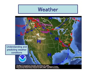
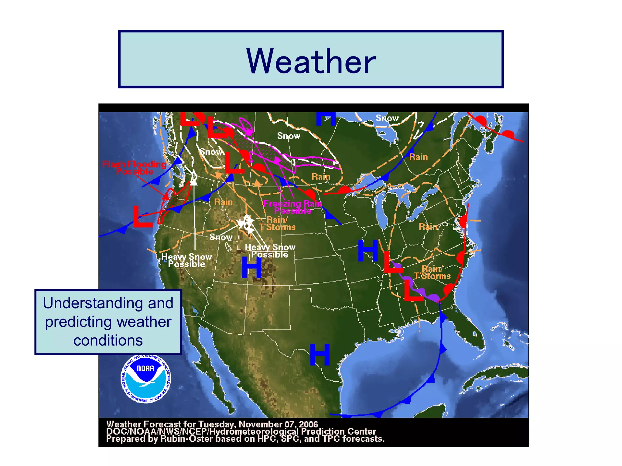
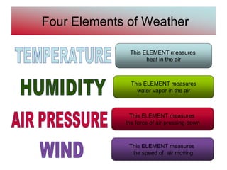
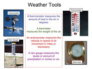
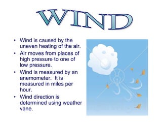
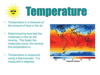
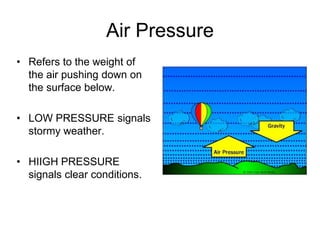
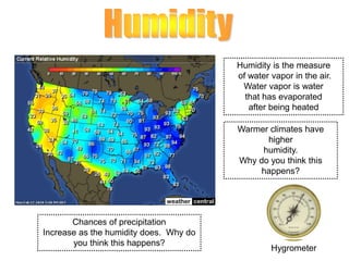
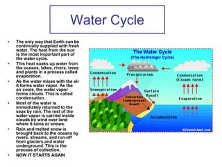
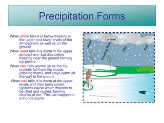
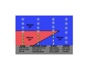
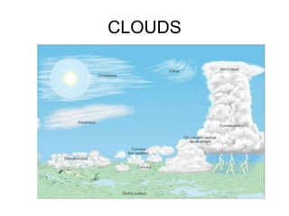
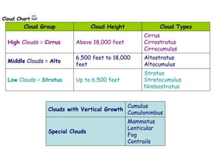
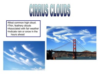
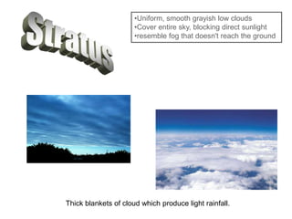
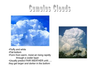
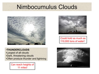
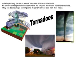
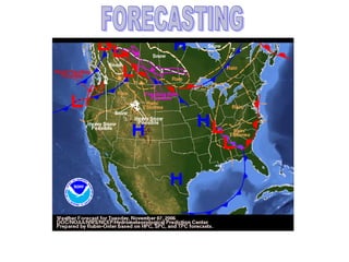
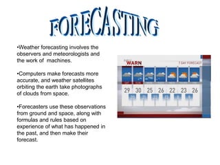
Weather
Understanding
& Predicting
Weather Conditions
Understanding and
predicting weather
conditions
Four Elements of Weather
This ELEMENT measures
heat in the air
This ELEMENT measures
water vapor in the air
This ELEMENT measures
the speed of air moving
This ELEMENT measures
the force of air pressing down
Weather Tools
Anemometer
Barometer
Thermometer
Rain Gauge
A thermometer measures the
amount of heat in the air in
degrees
A barometer
measures the weight of the air
An anemometer measures the
velocity or speed of air
movement in miles or
kilometers
A rain gauge measures the
levels or amount of
precipitation in inches or cm.
• Wind is caused by the
uneven heating of the air.
• Air moves from places of
high pressure to one of
low pressure.
• Wind is measured by an
anemometer. It is
measured in miles per
hour.
• Wind direction is
determined using weather
vane.
• Temperature is a measure of
the amount of heat in the air.
• Determined by how fast the
molecules in the air are
moving. The faster the
molecules move, the warmer
the temperature is.
• Temperature is measured
using a thermometer. It is
measured in degrees.
Air Pressure
• Refers to the weight of
the air pushing down on
the surface below.
• LOW PRESSURE signals
stormy weather.
• HIIGH PRESSURE
signals clear conditions.
Humidity is the measure
of water vapor in the air.
Water vapor is water
that has evaporated
after being heated
Chances of precipitation
Increase as the humidity does. Why do
you think this happens?
Warmer climates have
higher
humidity.
Why do you think this
happens?
Hygrometer
Water Cycle
• The only way that Earth can be
continually supplied with fresh
water. The heat from the sun
is the most important part of
the water cycle.
• This heat soaks up water from
the oceans, lakes, rivers, trees
and plants in a process called
evaporation.
• As the water mixes with the air
it forms water vapor. As the
air cools, the water vapor
forms clouds. This is called
condensation.
• Most of the water is
immediately returned to the
seas by rain. The rest of the
water vapor is carried inside
clouds by wind over land
where it rains or snows.
• Rain and melted snow is
brought back to the oceans by
rivers, streams, and run-off
from glaciers and water
underground. This is the
process of collection.
• NOW IT STARTS AGAIN
• Evaporation: Evaporation is when the sun heats up
water in rivers or lakes or the ocean and turns it into
vapor or steam. The water vapor or steam leaves the
river, lake or ocean and goes into the air.
• Do plants sweat?
• Well, sort of.... people perspire (sweat) and plants
transpire. Transpiration is the process by which plants
lose water out of their leaves. Transpiration gives
evaporation a bit of a hand in getting the water vapor
back up into the air.
•Precipitation: Precipitation occurs when so much water has
condensed that the air cannot hold it anymore. The clouds get
heavy and water falls back to the earth in the form of rain, hail,
sleet or snow.
•Condensation: Water vapor in the air
•gets cold and changes back into liquid.
•This is called condensation.
• Collection: When water falls back to earth as
precipitation, it may fall back in the oceans,
lakes or rivers or it may end up on land. When it
ends up on land, it will either soak into the earth
and become part of the “ground water” that
plants and animals use to drink or it may run
over the soil and collect in the oceans, lakes or
rivers where the cycle starts
all over again.
Precipitation Forms
When snow falls it is below freezing in
the upper and lower levels of the
atmosphere as well as on the
ground
When sleet falls it is warm in the upper
atmosphere, but dips below
freezing near the ground forming
icy pellets
When rain falls warms up as the icy
crystals fall from the clouds
(melting them), and stays warm all
the way to the ground
When hail falls, it is warm at the upper
levels and then turns colder.
Updrafts cause water droplets to
be lifted and cooled, forming
chunks of ice. This can happen in
a thunderstorm.
or sleet
CLOUDS
Cloud Chart
Cloud Group Cloud Height Cloud Types
High Clouds = Cirrus Above 18,000 feet
Cirrus
Cirrostratus
Cirrocumulus
Middle Clouds = Alto
6,500 feet to 18,000
feet
Altostratus
Altocumulus
Low Clouds = Stratus Up to 6,500 feet
Stratus
Stratocumulus
Nimbostratus
Clouds with Vertical Growth
Cumulus
Cumulonimbus
Special Clouds
Mammatus
Lenticular
Fog
Contrails
•Most common high cloud.
•Thin, feathery clouds
•Associated with fair weather
•Indicate rain or snow in the
hours ahead
•Uniform, smooth grayish low clouds
•Cover entire sky, blocking direct sunlight
•resemble fog that doesn't reach the ground
Thick blankets of cloud which produce light rainfall.
•Fluffy and white
•Flat bottom
•Form from warm, moist air rising rapidly
through a cooler layer
•Usually predict FAIR WEATHER until…..
they get larger and darker in the bottom
Nimbocumulus Clouds
•THUNDERCLOUDS
•Largest of all clouds
•Dark, threatening clouds
•Often produce thunder and lightning
Could hold as much as
110,000 tons of water!
Can reach heights of
11 miles!
FIRST
NEXT
THIRD
LAST
FRONTS and changing weather
Boundary between two air
masses of different
temperature and humidity.
•storm with lightning and thunder.
•produced by a cumulonimbus cloud,
•usually gusty winds,
•heavy rain and
•sometimes hail.
Needs moisture,
unstable air and lift.
moisture to form clouds
and rain,
unstable warm air
that can rise rapidly.
Finally… lift.
from fronts,
sea breezes
or mountains.
Violently rotating column of air that descends from a thunderstorm.
No other weather phenomenon can match the fury and destructive power of tornadoes.
They can destroy large buildings and lift 20-ton railroad cars from their tracks.
•Weather forecasting involves the
observers and meteorologists and
the work of machines.
•Computers make forecasts more
accurate, and weather satellites
orbiting the earth take photographs
of clouds from space.
•Forecasters use these observations
from ground and space, along with
formulas and rules based on
experience of what has happened in
the past, and then make their
forecast.

Weather slides

  • 1.
  • 2.
    Four Elements ofWeather This ELEMENT measures heat in the air This ELEMENT measures water vapor in the air This ELEMENT measures the speed of air moving This ELEMENT measures the force of air pressing down
  • 3.
    Weather Tools Anemometer Barometer Thermometer Rain Gauge Athermometer measures the amount of heat in the air in degrees A barometer measures the weight of the air An anemometer measures the velocity or speed of air movement in miles or kilometers A rain gauge measures the levels or amount of precipitation in inches or cm.
  • 4.
    • Wind iscaused by the uneven heating of the air. • Air moves from places of high pressure to one of low pressure. • Wind is measured by an anemometer. It is measured in miles per hour. • Wind direction is determined using weather vane.
  • 5.
    • Temperature isa measure of the amount of heat in the air. • Determined by how fast the molecules in the air are moving. The faster the molecules move, the warmer the temperature is. • Temperature is measured using a thermometer. It is measured in degrees.
  • 6.
    Air Pressure • Refersto the weight of the air pushing down on the surface below. • LOW PRESSURE signals stormy weather. • HIIGH PRESSURE signals clear conditions.
  • 7.
    Humidity is themeasure of water vapor in the air. Water vapor is water that has evaporated after being heated Chances of precipitation Increase as the humidity does. Why do you think this happens? Warmer climates have higher humidity. Why do you think this happens? Hygrometer
  • 8.
    Water Cycle • Theonly way that Earth can be continually supplied with fresh water. The heat from the sun is the most important part of the water cycle. • This heat soaks up water from the oceans, lakes, rivers, trees and plants in a process called evaporation. • As the water mixes with the air it forms water vapor. As the air cools, the water vapor forms clouds. This is called condensation. • Most of the water is immediately returned to the seas by rain. The rest of the water vapor is carried inside clouds by wind over land where it rains or snows. • Rain and melted snow is brought back to the oceans by rivers, streams, and run-off from glaciers and water underground. This is the process of collection. • NOW IT STARTS AGAIN
  • 9.
    • Evaporation: Evaporationis when the sun heats up water in rivers or lakes or the ocean and turns it into vapor or steam. The water vapor or steam leaves the river, lake or ocean and goes into the air. • Do plants sweat? • Well, sort of.... people perspire (sweat) and plants transpire. Transpiration is the process by which plants lose water out of their leaves. Transpiration gives evaporation a bit of a hand in getting the water vapor back up into the air.
  • 10.
    •Precipitation: Precipitation occurswhen so much water has condensed that the air cannot hold it anymore. The clouds get heavy and water falls back to the earth in the form of rain, hail, sleet or snow. •Condensation: Water vapor in the air •gets cold and changes back into liquid. •This is called condensation.
  • 11.
    • Collection: Whenwater falls back to earth as precipitation, it may fall back in the oceans, lakes or rivers or it may end up on land. When it ends up on land, it will either soak into the earth and become part of the “ground water” that plants and animals use to drink or it may run over the soil and collect in the oceans, lakes or rivers where the cycle starts all over again.
  • 12.
    Precipitation Forms When snowfalls it is below freezing in the upper and lower levels of the atmosphere as well as on the ground When sleet falls it is warm in the upper atmosphere, but dips below freezing near the ground forming icy pellets When rain falls warms up as the icy crystals fall from the clouds (melting them), and stays warm all the way to the ground When hail falls, it is warm at the upper levels and then turns colder. Updrafts cause water droplets to be lifted and cooled, forming chunks of ice. This can happen in a thunderstorm. or sleet
  • 14.
  • 15.
    Cloud Chart Cloud GroupCloud Height Cloud Types High Clouds = Cirrus Above 18,000 feet Cirrus Cirrostratus Cirrocumulus Middle Clouds = Alto 6,500 feet to 18,000 feet Altostratus Altocumulus Low Clouds = Stratus Up to 6,500 feet Stratus Stratocumulus Nimbostratus Clouds with Vertical Growth Cumulus Cumulonimbus Special Clouds Mammatus Lenticular Fog Contrails
  • 16.
    •Most common highcloud. •Thin, feathery clouds •Associated with fair weather •Indicate rain or snow in the hours ahead
  • 17.
    •Uniform, smooth grayishlow clouds •Cover entire sky, blocking direct sunlight •resemble fog that doesn't reach the ground Thick blankets of cloud which produce light rainfall.
  • 18.
    •Fluffy and white •Flatbottom •Form from warm, moist air rising rapidly through a cooler layer •Usually predict FAIR WEATHER until….. they get larger and darker in the bottom
  • 19.
    Nimbocumulus Clouds •THUNDERCLOUDS •Largest ofall clouds •Dark, threatening clouds •Often produce thunder and lightning Could hold as much as 110,000 tons of water! Can reach heights of 11 miles!
  • 20.
  • 21.
    FRONTS and changingweather Boundary between two air masses of different temperature and humidity.
  • 22.
    •storm with lightningand thunder. •produced by a cumulonimbus cloud, •usually gusty winds, •heavy rain and •sometimes hail. Needs moisture, unstable air and lift. moisture to form clouds and rain, unstable warm air that can rise rapidly. Finally… lift. from fronts, sea breezes or mountains.
  • 24.
    Violently rotating columnof air that descends from a thunderstorm. No other weather phenomenon can match the fury and destructive power of tornadoes. They can destroy large buildings and lift 20-ton railroad cars from their tracks.
  • 26.
    •Weather forecasting involvesthe observers and meteorologists and the work of machines. •Computers make forecasts more accurate, and weather satellites orbiting the earth take photographs of clouds from space. •Forecasters use these observations from ground and space, along with formulas and rules based on experience of what has happened in the past, and then make their forecast.