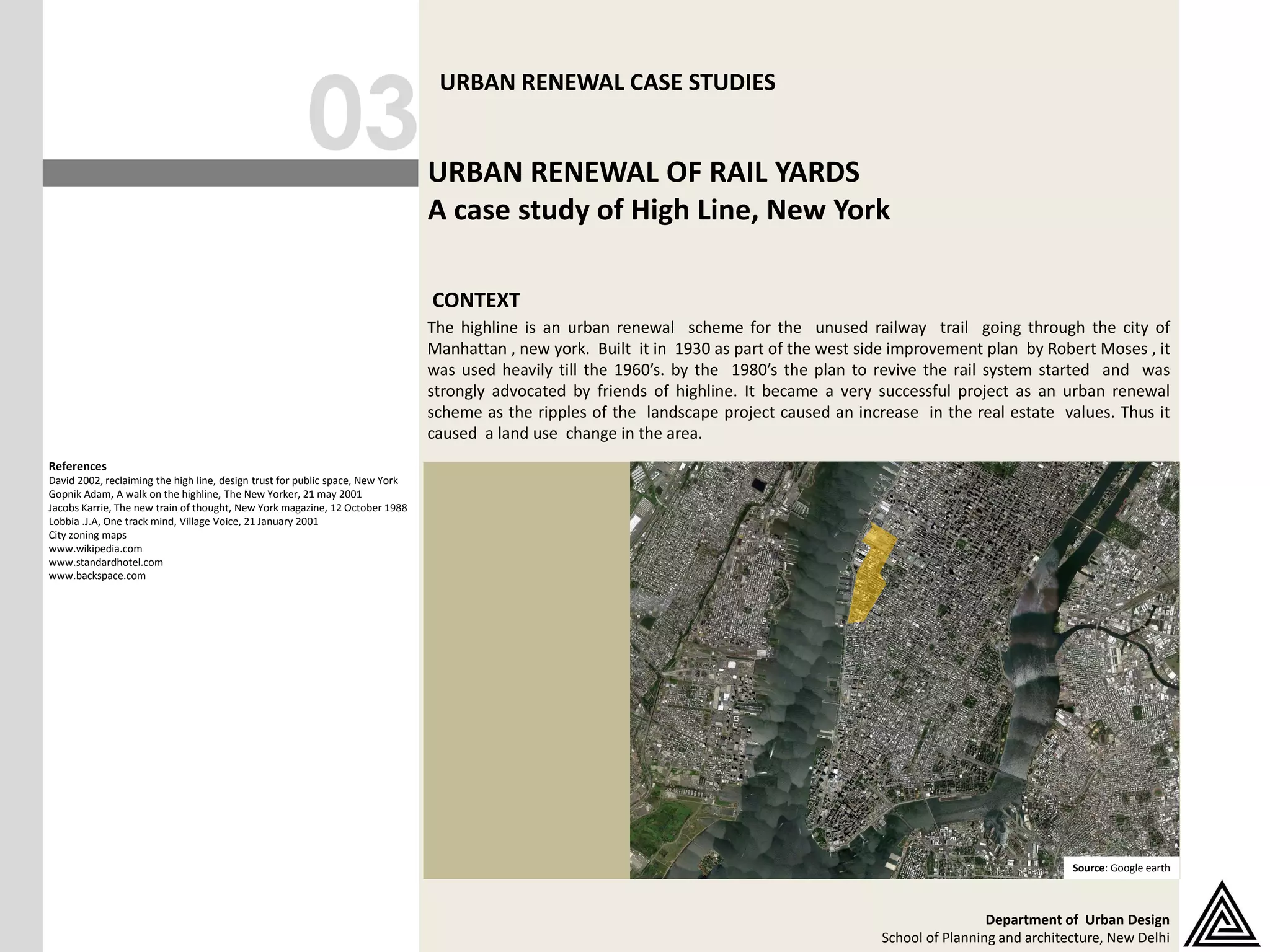
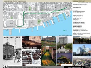
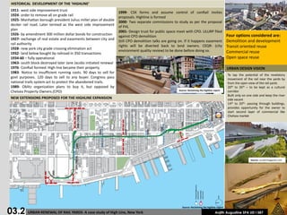
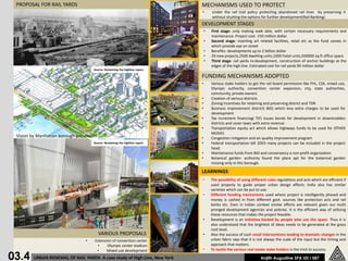
The High Line in Manhattan was an abandoned elevated railway that was reused as an urban renewal project. Built in the 1930s, it fell into disuse by the 1980s. In the 2000s, Friends of the High Line advocated to preserve and reuse the structure as a public park. The project transformed the area, increasing property values and catalyzing new development. It proved successful by using various funding mechanisms and zoning incentives to develop in stages while protecting the rail infrastructure under federal rail banking policies.
Street Design Workshop
Council of Architecture Training & Research centre, Pune
29.06.18
Case: Fergusson College Road, Pune
(FC college junction to Lalit mahal chowk)
Team: Sandeep Paul, Maitri Shah, Taha Padrawala ,Praveen Suthar
Mentors: Darpana Athale, Rahul Kadam, Jayshree Deshpande, Prasanna Desai, Rajiv Raje and Khushru Irani
12 Case Studies: Adaptive Reuse of Industrial BuildingsSeventh Hill
Graduate students at Kent State University's Cleveland Urban Design Collaborative researched case studies on adaptive reuse of industrial buildings. The document includes an edited version of each case study presentation created by the students. The 12 projects are located in cities from around the world and include a range of new uses. The case studies served as inspiration for the students' Spring 2016 Urban Design Studio focused on redevelopment proposals for Cleveland's Lake Shore Power Plant. For more information on Kent State University's Cleveland Urban Design Collaborative, please visit: www.cudc.kent.edu
As the flagship project for the next downtown Boston neighborhood slated for growth, Atlantic Wharf will be the city of Boston’s first LEED Gold mixed-use development. CBT Architects presents a case study on this new one million square foot project that includes approximately 65 residential units, ground-level retail and public spaces, six stories of below-grade parking, and 31 floors of office space that will bring urban activity directly to the Fort Point Channel water’s edge.
The new sustainable development is at the base of a series of restored and renovated historic structures that preserve the texture and streetscape of this site, integrated with a modern highrise glass tower. By preserving the south and east façades of the historic warehouses, using a very energy-efficient curtainwall, and employing green roof technologies, Atlantic Wharf will be the a centerpiece of Boston's green development.
Sabarmati riverfront case study for development of yamuna riverfront agradeeksha sharma
the
the Sabarmati riverfront ahmedabad is a huge successful project. this presentation is about the case study of that riverfront to take the features similar to the the Yamuna riverfront Agra for urban design development project.
Singapore, officially the Republic of Singapore, is a sovereign island city-state in Southeast Asia.
It is located at the end of the Malayan Peninsula between Malaysia and Indonesia.
Singapore has a total land area of 724.2 square kilometers.
Singapore's territory consists of one main island along with 58 other islets.
Since independence[1965], extensive land reclamation has increased its total size by 23%.
Singapore is very small in size and confined. so, there every sq. meter matters.
Now, 90% of citizens in Singapore own their houses.
Urban planning in Singapore has formulated and guided its physical development from the day Singapore was founded in 1819 as a British colony to the developed, independent country it is today.
Urban planning is especially important due to land constraints and its high density.
The Urban Redevelopment Authority (URA) is Singapore's national land-use planning authority.
URA prepares long term strategic plans, as well as detailed local area plans, for physical development, and then co-ordinates and guides efforts to bring these plans to reality.
Prudent land use planning has enabled Singapore to enjoy strong economic growth and social cohesion, and ensures that sufficient land is safeguarded to support continued economic progress and future development
In 1822, Raffles initiated a comprehensive town plan called land use plan.
This plan to guide the allocation of land in the principal town to ensure that its physical growth followed an orderly pattern.
This became known as the Raffles Town Plan, or the Jackson Plan, drawn up by Lieutenant Philip Jackson and published in 1828.
Among its key features were a GRID LAYOUT for the road network and a clear segregation of residential communities by ethnic group (European, Chinese, Indian, Malay and Arab).
A separate area called Commercial Square (later renamed Raffles Place) was designated for commercial activities and another area was zoned for government functions.
Raffles Place and the street pattern of the city Centre
today are evidence of this colonial legacy.
Urban Design-Literature study St. Marks Road, BangaloreAnsh Agarwal
Urban Planning
Literature study of St. Marks Road, Bangalore.
Includes:
1. Road Details
2. Survey Details & Analysis
3. Action Needed
4. Proposals
5. Action Made
6. Before & After Scenerio
7. Anatomy of Changes
It is an assignment on urban design basic factors, whereas a designer should keep in mind in urban designing.
Here I tried to describe factors by pointing as anyone could find a basic concept o urban design. Hope it'll be helpful.
INTRODUCTION
COORDINATES - 23.22 ON 72.680 E ELEVATION - 265 feet (81 m)*
LOCATED 23 KM NORTH OF AHEMDABAD (FIN CAP. OF GUJARAT)
PLANNED IN 1960S BY, PRAKASH M APTE & H. K. MEWADA,
AFTER PARTITION OF BOMBAY * STATE : AHEMDABAD WAS MADE AS THE CAPTAL OFGUJARAT
AREA TOTAL 177KM2 ELEVATION : 8IM ( 266 FT)
POPULATION (2011)
TOTAL: 206,167 DENSITY : 1,200/KM2
CLIMATE*
TROPICAL WET AND DRY CLIMATE•
SUMMER MAXIMUM - 36 to 42 °C MINIMUM - 19 to 27 C
WINTER MAXIMUM - 29 C MINIMUM - 14°C
MONSOON: THE AVERAGE ANNUAL RAINFALL IS AROUND 803.4 MM
LANGUAGES
GUJARATI, HINDI, AND ENGLISH• 54% GREEN COVER ON ITS LAND AREA
• THE CITY SITS ON THE BANKS OF THE SABARMATI RIVER, IN NORTH-CENTRALEAST GUJARAT
HISTORY
IN 1960, THE INDIAN STATE OF BOMBAY WAS SPLIT INTO TWO STATES, MAHARASHTRA AND GUJARAT LEAVING GUJARAT WITHOUT A CAPITAL CITY.
AT THE TIME AHMEDABAD WAS SELECTED TO BE THE FIRST CAPITAL OF THE NEWLY CREATED STATE.
• IT WAS LATER PROPOSED THAT A NEW CAPITAL CITY BE CONSTRUCTED FOR THE STATE.
• GANDHINAGAR GOT AN IDENTITY OF ITS OWN WHEN THE STATE OF MUMBAI WAS DIVIDED INTO TWO SEPARATE STATES OF GUJARAT AND MAHARASHTRA.
• IN THE BEGINNING, AHMEDABAD - A COMMERCIAL HUB OF GUJARAT WAS CHOSEN AS THE STATE CAPITAL AND IT WAS PROPOSED THAT A NEW CAPITAL SHOULD BE CONSTRUCTED ALONG THE LINE OF OTHER NEW STATE CAPITALS, PARTICULARLY CHANDIGARH
• THEREFORE TWO WELL-KNOWN INDIAN ARCHITECTS, H.K. MEWADA AND PRAKASH M. APTE (WHO WORKED AS BEGINNER FOR THE CHANDIGARH CITY) DESIGNED THE NEW STATE CAPITAL*
NAMED AFTER MAHATMA GANDHI THE FOUNDATION STONE OF THIS CITY WAS LAID ON 1965 AND IN 1971 THE CAPITAL WAS SHIFTED FROM AHMEDABAD TO GANDHINAGAR
PLANNING
• PLANNED AND IMPLEMENTED BETWEEN 1965-1970
• DETERMINATION TO MAKE GANDHINAGAR A PURELY INDIAN ENTERPRISE, PARTLY BECAUSE GUJARAT WAS THE BIRTHPLACE OF GANDHI.
• TO ESTABLISH AND MAINTAIN A SEPARATE IDENTITY FOR THE NEW CITY THE SURROUNDING AREA OF ABOUT 39 VILLAGES WAS BROUGHT UNDER A PERIPHERY CONTROL ACT (AS IN CHANDIGARH)
• THE AREA LATER CONSTITUTED A SEPARATE ADMINISTRATIVE DISTRICT OF GANDHINAGAR.
• THE CITY WAS PLANNED FOR A POPULATION OF 150,000 BUT CAN ACCOMMODATE DOUBLE THAT POPULATION WITH INCREASE IN THE FLOOR SPACE RATIO FROM 1 TO 2 IN THE AREAS RESERVED FOR PRIVATE DEVELOPMENT.
• THE RIVER BEING THE BORDER ON THE EAST, AND THE INDUSTRIAL AREA TO THE NORTH, THE MOST LOGICAL FUTURE PHYSICAL EXPANSION OF THE CITY WAS ENVISAGED TOWARDS THE NORTH-WEST
A Report on Urban Redevelopment which covers Introduction, Indicators of Redevelopment(Construction, Rehabilitation & Relocation), Local Study(Bangladesh), International Study of Redevelopment, Preservation aspect, and most important part of Redevelopment i.e. Methodology.
A complete case study on group housing project,
sustainable environment.
Housing society studied are
1) Amrapali Vananchal City, Bhilai
2) Amrapali Silicon City, Noida
3) Interlace Housing, Singapore
The High Line — Exploring New York’s raised linear parkInleaf
Exploring the living plants and features of New York's High Line. Explore the raised linear park in pictures.
Resources and links of interest
The High Line website
http://www.thehighline.org/
Support The High Line
https://www.thehighline.org/shop
The High Line blog
https://www.thehighline.org/blog
Inleaf — Office plant displays
https://inleaf.co.uk/
High resolution versions of the images in this presentation available for download, free for all uses with credit & link
https://inleaf.co.uk/exploring-new-yorks-high-line/
Making and Unmaking of Chandigarh - - making public spaces [Autosaved] - Copy...JIT KUMAR GUPTA
Chandigrah is known as a city of crisis. It was conceptulised, planned, designed, constructed in crisis.Even after 72 years of its launch, It continues to be in crisis. It faces crisis of population, development, prosperity, poverty, haphazard and unplanned development. It presents a crisis of travel and traffic. Despite all challenges, cities remains a role model of development, planning of town and cities. It has many messages for professionals. City remains a working lab for the professional architects, planners, engineers and urban managers. City needs to studies, evaluated and analysed as to how one can plan and design a neat , clean and sustainable city. Despite the fact Chandigarh remains a designed city, it holds all the values and principles of planned development. Chandigarh needs to be valued in terms of its role and importance in urban planning, architecture and development. Credit for all this goes to the first team of professionals led by American Architet Albert Mayer; Second team led by Le-Corbusier,P Jenneret; Maxwell Fry; Jane B Drew; Chief Engineer P L Verma; Project Chief Sh P N Thapar ICS; Planner Sh N S Lmba, Young Indian team of young architects including; Architects Prabhawalkar; Aditya Prakash; Jeet Malhotra; Bhanu Mathur.
Making and Unmaking of Chandigarh - A City of Two Plans2-4-24.pptJIT KUMAR GUPTA
Presentation is a narrative of a
capital city- known for its innovative planning, designing, construction and management of a new capital . It briefs about the principles used in the planning and designing of city -by the first team of planners led by Albert Mayer and Mathew Nowicki-- followed by the second team led by Le- Corbusier, P Jenerette, Jane B Drew , Maxwell Fry. It also details about the various aspects of the city planning, planning of the sector as a neighbourhood, typologies of
various developmental controls used for regulating the construction of buildings. Innovations used for regulating the growth and development of periphery; redensification of city in case city exceeds its planned population of half a million, creating a narrative of city and periphery, innovative landscaping, defining an edict for the city to educate the future citizens of the capital city to safeguard the future growth and development besides lessons learnt from planning and designing the new cities.
Representative academic work from my first year of study in architecture, plus a sprinkling of personal freehand, illustration, and manual arts projects.
This presentation describes the history of public transit, automobile, and pedestrian/cycling transport in Canberra, Australia's capital, over the past 100 years with some thoughts about what the past implies about the future trends in Canberra and in other cities around the world like it. This presentation was made as part of a conference celebrating Canberra's Centenary in 2013.
Though 100 smart cities is being talked around many times, common people still doesn't clearly know what exactly the project is. This presentation will help to orient yourselves to the 100 smart cities project. This is in no way the ideas of the author or is influenced by the authors opinions. The presentation is purely based on the vision, mission and strategies of India Govt guidelines.
Unleash Your Inner Demon with the "Let's Summon Demons" T-Shirt. Calling all fans of dark humor and edgy fashion! The "Let's Summon Demons" t-shirt is a unique way to express yourself and turn heads.
https://dribbble.com/shots/24253051-Let-s-Summon-Demons-Shirt
Hello everyone! I am thrilled to present my latest portfolio on LinkedIn, marking the culmination of my architectural journey thus far. Over the span of five years, I've been fortunate to acquire a wealth of knowledge under the guidance of esteemed professors and industry mentors. From rigorous academic pursuits to practical engagements, each experience has contributed to my growth and refinement as an architecture student. This portfolio not only showcases my projects but also underscores my attention to detail and to innovative architecture as a profession.
Book Formatting: Quality Control Checks for DesignersConfidence Ago
This presentation was made to help designers who work in publishing houses or format books for printing ensure quality.
Quality control is vital to every industry. This is why every department in a company need create a method they use in ensuring quality. This, perhaps, will not only improve the quality of products and bring errors to the barest minimum, but take it to a near perfect finish.
It is beyond a moot point that a good book will somewhat be judged by its cover, but the content of the book remains king. No matter how beautiful the cover, if the quality of writing or presentation is off, that will be a reason for readers not to come back to the book or recommend it.
So, this presentation points designers to some important things that may be missed by an editor that they could eventually discover and call the attention of the editor.
7 Alternatives to Bullet Points in PowerPointAlvis Oh
So you tried all the ways to beautify your bullet points on your pitch deck but it just got way uglier. These points are supposed to be memorable and leave a lasting impression on your audience. With these tips, you'll no longer have to spend so much time thinking how you should present your pointers.
1. 03
URBAN RENEWAL CASE STUDIES
URBAN RENEWAL OF RAIL YARDS
A case study of High Line, New York
CONTEXT
The highline is an urban renewal scheme for the unused railway trail going through the city of
Manhattan , new york. Built it in 1930 as part of the west side improvement plan by Robert Moses , it
was used heavily till the 1960’s. by the 1980’s the plan to revive the rail system started and was
strongly advocated by friends of highline. It became a very successful project as an urban renewal
scheme as the ripples of the landscape project caused an increase in the real estate values. Thus it
caused a land use change in the area.
References
David 2002, reclaiming the high line, design trust for public space, New York
Gopnik Adam, A walk on the highline, The New Yorker, 21 may 2001
Jacobs Karrie, The new train of thought, New York magazine, 12 October 1988
Lobbia .J.A, One track mind, Village Voice, 21 January 2001
City zoning maps
www.wikipedia.com
www.standardhotel.com
www.backspace.com
CONTEXT MAP
Source: Google earth
Department of Urban Design
School of Planning and architecture, New Delhi
2. HIGHLINE, WEST MANHATTAN, NEW YORK HIGH LINE FACT SHEET
Source: Reclaiming the highline report
’ Source:architecturelab.net
’
Source: Reclaiming the highline report Source: freetoursbyfoot.com
03.1 URBAN RENEWAL OF RAIL YARDS- A case study of High Line, New York Anjith Augustine SPA UD I 587
3. HISTORICAL DEVELOPMENT OF THE ‘HIGHLINE’
1911- west side improvement trust
1999- CSX forms and assume control of conRail invites
1924- order to remove all on grade rail
proposals. Highline is formed
1925- Manhattan borough president Julius miller plan of double
2000- Two separate commissions to study as per the proposal
decker rail road. Later termed as the west side improvement
of FHL
plan
2001- Design trust for public space meet with CPO. ULURP filed
1926- by amendment 300 million dollar bonds for construction Four options considered are:
against CPO demolition
1927- exchange of real estate and easements between city and
Still CPO demolition talks are going on. If it happens easement Demolition and development
rail authority
rights will be diverted back to land owners. CEQR- (city Transit oriented reuse
1928- new york city grade crossing elimination act
environment quality review) to be done before doing so. Commercial reuse
1932- land below bought by railroad in 350 transactions
1934-60 – fully operational Open space reuse
1963- south block destroyed later Jane Jacobs initiated renewal
1976- ConRail formed. High line became their property URBAN DESIGN VISION
1983- Notice to insufficient running costs. 90 days to sell for
To tap the potential of the revelatory
govt purposes. 120 days to sell to any buyer. Congress pass movement of the rail near the yards by
national trails system act to protect the abandoned trails. from the open view of the rail yards
1989- Oblitz organization plans to buy it, but opposed by 20th to 26th – to be kept as a cultural
Source: Reclaiming the highline report
Chelsea Property Owners.(CPO) corridor
Built only on one side and keep the river
NEW EXTENSIONS PROPOSED FOR THE HIGHLINE EXPANSION side vacant
14th to 20th- passing through buildings,
provides opportunity for the owner to
start second layer of commercial like
Chelsea market
Source: curatormagazine.com
03.2 URBAN RENEWAL OF RAIL YARDS- A case study of High Line, New York
Source: Reclaiming the highline report
Anjith Augustine SPA UD I 587
4. EXISTING LAND USE
• Mi-5 landu se less intense manufacturing
and other land uses like housing and
community facilities max far-5
• Community facilities 6.5
• Mi-2 and m1-3 heavy manufacturing
• Art uses line the highline
• Pressure from land owners adjacent to
change the land use predominantly
manufacturing
Source: Reclaiming the highline report
Source: curatormagazine.com
PROPOSED LAND USE
• Allowed residential mix on the lower areas
• 11th street night clubs boon and bane in
disguise- hence controlled land use
modifications
• Glaesvroot to be preserved as heritage
03.3
Source: Reclaiming the highline report
URBAN RENEWAL OF RAIL YARDS- A case study of High Line, New York Anjith Augustine SPA UD I 587
5. PROPOSAL FOR RAIL YARDS MECHANISMS USED TO PROTECT
• Under the rail trail policy protecting abandoned rail lines by preserving it
without shutting the options for further development(Rail Banking)
DEVELOPMENT STAGES
• First stage- only making walk able, with certain necessary requirements and
maintenance. Project cost- 150 million dollar
• Second stage- inserting art related facilities, retail etc as the fund comes in
which provide eye on street
• Benefits- developments up to 2 billion dollar
• 29 new projects,2500 dwelling units,1000 hotel units,500000 sq.ft office space
• Third stage- rail yards re-development, construction of anchor buildings at the
edges of the high line. Estimated cost for rail yards 90 million dollar
Source: Reclaiming the highline report
FUNDING MECHANISMS ADOPTED
• Various stake holders to get the rail board permission like FHL, CSX, mixed use,
Olympic authority, convention center expansion, city, state authorities,
community, private owners
• Creation of various districts
• Zoning incentives for retaining and preserving district and TDR.
• Business improvement district( BID) which levy extra charges to be used for
development
• Tax increment financing( TIF) issues bonds for development in downtrodden
districts and cover taxes with extra revenue
• Transportation equity act which allows highways funds to be used for OTHER
MODES
Vision by Manhattan borough president • Congestion mitigation and air quality improvement program
Source: Reclaiming the highline report • Federal transportation bill 2003 many projects can be included in the project
head.
• Maintenance funds from BID and conservancy a non profit organization
• Botanical garden- authority found the place apt for the botanical garden
missing only in this borough.
LEARNINGS
• The possibility of using different rules regulations and acts which are efficient if
used properly to guide proper urban design efforts. India also has similar
varieties which can be put to use.
• Different funding mechanisms used where project is intelligently phased and
money is cashed in from different govt. sources like protection acts and rail
banks etc. Even in Indian context similar efforts are relevant given our multi
pronged development agencies and policies. It is the efficient way of utilizing
these resources that makes the project feasible.
• Development is an initiative backed by people who use the space. Thus it is
also understood that the brightest of ideas needs to be generated at the grass
root level.
VARIOUS PROPOSALS • Also the success of such small interventions leading to dramatic changes in the
• Extension of convention center urban fabric says that it is not always the scale of the input but the timing and
• Olympic center stadium approach that matters.
• • To tackle the various real estate stake holders is the trick to success.
03.4
Mixed use development
URBAN RENEWAL OF RAIL YARDS- A case study of High Line, New York Anjith Augustine SPA UD I 587