Capella Week 1 H4D Stanford 2016
•
1 like•29,526 views

agile, business model, corporate innovation, customer development, h4d, hacking for defense, lean, lean launchpad, lean startup, stanford, steve blank, bmnt, diux

Recommended
More Related Content
What's hot
What's hot (20)
Viewers also liked
Viewers also liked (20)
Similar to Capella Week 1 H4D Stanford 2016
Similar to Capella Week 1 H4D Stanford 2016 (20)
More from Stanford University
More from Stanford University (20)
Recently uploaded
Recently uploaded (20)
Capella Week 1 H4D Stanford 2016
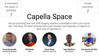
- 1. Capella Space We are providing low-cost SAR imagery satellite constellation with a low revisit rate. The Navy 7th Fleet will know the exact location and trajectory of objects in their area of operations. Payam Banazadeh Aerospace/Business Timon Ruban Machine Learning Isaac Matthews Aerospace Jose Ignacio del Villar Business Will Woods SAR # interviews this week (3 pending): 7 # total interviews: 7 Redacted Redacted
- 2. Contacts Sponsor: ● Col. Steve Butow, DIUx, USAF Mentors: ● Maj. Ryan Space, DIUx, USAF ● Tim Newell, BMNT Capital ● Dave Slayton, Hoover Research Institute ● Pete Stevenson, Intel ● Michael Calabro - Booze Allen Hamilton ● Laura Yu - Booze Allen Hamilton ● Col. Darren Halford - USAF Military Liaisons: ● LtC Ryan Blake, Stanford Military Fellow, USAF ● LtC Steve Behmer, Stanford Military Fellow, USAF Redacted Redacted
- 5. Redacted
- 6. Redacted
- 8. Experiment #1 - Satellite constellation IS the product Hypothesis Experiment Result Action Our product consists of providing a satellite constellation so that the users have access to the raw images whenever they want Several interviews with stakeholders and mentors Instead of selling the constellations, sell the data extracted from the images with data analytics and machine learning algorithms. Focus our conversations for future interviews on the value of the data extracted from the images and not our technology. Redacted Redacted Redacted Redacted Redact ed Redac ted Redacted
- 9. Experiment #2 - SAR resolution necessity Hypothesis Experiment Result Action Using high-resolution (1m/pixel) SAR imagery to track targets is useful for the US military Interviewing Lt. Col. Ryan Blake of the US Air Force SAR Imagery can be used for targeting fixed structures in the US Air Force => 5-10m/pixel resolution is sufficient This data point helps us refine our thinking, but we need to interview more stakeholders before we know what is the required resolution Redacted Redacted Redacted Redacted Redacted
- 10. • Deploy 1 to 3 satellites and sell the images by September 2017. • Finish the deployment of 40 satellites by 2020. • Construction of payload for testing • Development of image analysis algorithms • Construction of satellite under required constraints • Data Analytics providers (Orbital Insight, Omni Earth, etc) • Sponsors (military and commercial) • Satellite structure providers • Satellite component providers • Orbital communication providers • Satellite launch providers • Get a customer in a country in the Equatorial orbit (Government) • Get commercial customers interested enough in our tech • The DHS and other government departments adopt our technology: • - USCG: to thwart drug trafficking from Ecuador and Colombia • Summer ground demonstration: $50k • First satellite: $6 million (including operations) • Subsequent satellites: $3 million each • Final constellation: $150 million total over 3 years • Funding to perform payload test during Summer 2016 • Government advocacy for our technology: DHS • Contacts in the Equatorial countries’ government agencies. Beneficiaries Mission AchievementMission Budget/Costs Buy-In/Support Deployment Value PropositionKey Activities Key Resources Commercial Satellite imagery resellers Illegal fishing in Indonesia Oil tankering in Nigeria Stop pirating at sea in Somalia Key Partners USCG Law Enforcement DO Information Watch Officer USCG - Stop more boats carrying drugs from Ecuador/Colombia - Reduce the cost of drug intervention operations NGA Provide better intelligence to other agencies/services Commercial Satellite Imagery Resellers: they can offer better and more diverse products Illegal fishing: tracking of ships that are doing suspicious activities at sea. Better law enforcement. NGA Intelligence Analysts Services in the DoD?? SOCOM Government sector driving demand (Indonesia, Nigeria, Ecuador, Colombia) Coast Guard Deputy Commandant for Operations (CG-DCO) Redacted Redacted Redacted Redacted Redacted Redacted Redacted Redacted Redacted
- 11. Here’s What We’re Doing Next… 1)Get granular with key stakeholders to try to understand WHO needs WHICH intelligence WHEN and HOW to get it in their hands 2)Test what the actionable insight from our image analysis would look like for the customer in a mock-up 3)Gain insights of current U.S. regulatory frameworks regarding the handling of high resolution geographical imaging and data. 4)Populate a list of competitors/ collaborators in space-based and high-altitude SAR applications (private and public sector). Redacted Redacted RedactedRedacted Redacted Redacted Redacted Redacted
Editor's Notes
- We have reached out to our assigned mentors, sponsors, and military liaisons and are leveraging the connections of this network to provide critical insights to open doors to contacts in the Navy 7th Fleet, and the military at large. Through our conversations, we have discovered that the US Navy and Coast Guard is interested in employing state of the art imaging platforms for wide area and continuous monitoring, specifically in the Arctic - SAR is a unique technology that affords the Navy and Coast Guard this capability. We have additionally discovered that the private sector, particularly companies in the Arctic region involved with the commerce, transportation, and exploitation of natural resources, may have an interest in the technology.