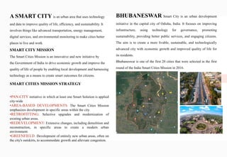
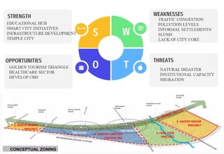
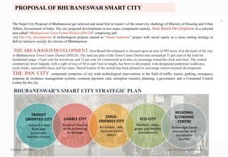
Bhubaneswar Smart City is an urban development initiative aimed at enhancing infrastructure, governance, sustainability, and public services through technology in the capital city of Odisha, India. It was one of the first cities selected in India's Smart Cities Mission in 2016 and emphasizes area-based development and pan-city technological solutions to foster economic growth and improve residents' quality of life. Challenges such as rising air pollution and traffic congestion are identified, highlighting the need for a strategic shift towards technology in future planning.
![TOWN PLANNING SMART CITY BHUBNESWAR
6
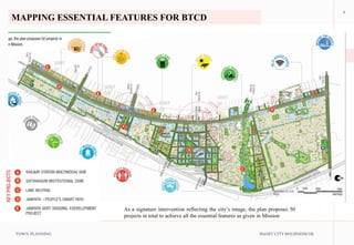
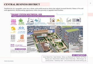
PROPOSED AREA BASED DEVELOPMENT [ BHUBNESWAR TOWN CENTRE
DISTRICT]](https://image.slidesharecdn.com/smartcitybyjashan-231109151241-461ac82d/85/SMART-CITY-CASE-STUDY-6-320.jpg)
![TOWN PLANNING SMART CITY BHUBNESWAR
7
PROPOSED AREA BASED DEVELOPMENT [ BHUBNESWAR TOWN CENTRE
DISTRICT]](https://image.slidesharecdn.com/smartcitybyjashan-231109151241-461ac82d/85/SMART-CITY-CASE-STUDY-7-320.jpg)


![Smart.city.VSIT.Vasad.April.6.21 [Autosaved] (1).pptx](https://cdn.slidesharecdn.com/ss_thumbnails/smart-250417130949-fe17247c-thumbnail.jpg?width=640&height=640&fit=bounds)