Urban study of Adyar
•
11 likes•6,603 views

The document provides a history of the development of Chennai city from its establishment in 1637. It details how the city grew from a small fishing village called Madraspatnam due to establishment of St. George fort by the British. The city's growth was supported by development of trade activities in the port and construction of roads connecting the coast to surrounding areas. Major institutions, housing developments, and infrastructure projects over the 20th century further accelerated the expansion of Chennai. The study area saw tremendous growth due to establishment of educational institutes and implementation of development plans after independence.

Recommended
Recommended
More Related Content
What's hot
What's hot (20)
Similar to Urban study of Adyar
Similar to Urban study of Adyar (20)
More from Geeva Chandana
More from Geeva Chandana (20)
Recently uploaded
Recently uploaded (20)
Urban study of Adyar
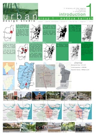
- 1. introduction / / h i s t o r y o f t h e r e g i o n / / l o c a t i o n / / p r o x i m i t i e s 1633 1733 1798 1875 1923 1965 1975 / / growth o f chennai city st arte d with the estab- l i shme nt o f St.George f ort by B ristish company / / t his la id the founda- t i on of th e city in the ol d fish er man village cal l ed ma da rasapattinam // due to the trade activi - ties in the port, the need for tansport made way fo r the finger like road net- work from the coast to the periphery and surroun d - ing villages at that tim e // the british govern - ment started to develop the indo-saracenic styl e building along the coas t / /// the establishemt of fort in turn favoured the trade around the area // so the port started to develop with paral- lel devolpment of small agraharams like tripli- cane, mylapore area with temple as the nuleus // th e i n c r e a s e i n d e n s i ty a t th e c e n tr a l c o r e ma d e th e p e o p l e to s h i ft a n d s e ttl e a l o n g th e r o a d - wa y s // ti l l th i s p e r i o d th e d e - v e l o p me n t wa s h a p p e n - i n g ma i n l y b e twe e n th e c o o v u m a n d a d y a r r i v e r // th e d e n s i ty o f th e c e n - tr a l b u i s n e s s d i s tr i c t ( CB D) wa s g e tti n g d e n s e r // a fte r i n d e p e n d e n c e , th e u r b a n a g g l o me r a - ti o n h a p p e n d a s a r e - s u l t o f fi v e y e a r p l a n s a n d c h a n g e i n p o l i - c i e s b y th e g o v e r n me n t // city started to grow i n a radial way with the r i n g road connection th ose m ain roads // south and west side o f the city is facing tr e m endous growth com - p a red to other parts of th e city india tamil nadu health care proximity insitutional proximity transport proximity chennai kasthuribhai nagar indira nagar gandhi nagar pallipattu ward no : 175 zone : Adyar area : 1.8sq.km area : 2.6sq.km area : 0.2sq.km area : 1.1sq.km ward no : 174 zone : Adyar area : 2.8sq.km zone : Adyar ward no : 180 area : 2.8sq.km kottur adyar chennai Me tr o p o l i to n A r e a : 9 ,121,477 Cu r r e n t p o p u l a ti o n : 4 ,828,858 P o p u l a ti o n d e n s i ty : 2 6903per sq.km 1u r b a nd e s i g n s t u d i o g r o u p 1 : m a d h y a k a i l a s h c a y s e r | g e e v a c h a n d a n a | h a r s h i n i | k a v i p r i y a | r a a g h a v i | r o h i t Adyar Can cer Institute Malar fortis Hospital Anna University K e n d i r a Vi d y a l a y a G u i n d y Me tr o Ma d h y a K a i lash Junction V HS Hosp ita l Menangudy Hospital IIT Chennai Hi n d u S e n i o r S c h o o l G u i n d y P a r k L a tti c e B r i d g e road
- 2. p h y s i c a l / / b u i l d i n g u s e / / h e i g h t s / / f i g u r e g r o u n d 2 1800 1900 / / estab lishment of Chennai in 1637 / / bucking ha m canal of 107m was fromed by connecting Coovu m r ive r and adyar river / / t his favo ur ed the deveopment the farmlands, residen- t i al s pa ces a nd garage // St.Patrices edu c a ti o n a l i n s ti tu te wa s s ta r te d i n 1 8 7 4 // this favoured th e r e s i d e n ti a l d e v o l o p me n t a l o n g th e northen streach o f B u c k i n g h a m c a n a l // th e i n c r e a s e i n th e r e s i d e n ti a l u n its near the educa- ti o n a l i n s ti tu te // th e c o mme r c i a l a r e a s th a t wa s a l so developing arong th e c a n a l a r e a s wa s a l s o i n c r e a s i n g 1914 1934 1974 2004 / / t he institute s like CLRI , centre polytechnic college were star ted / / t he r oa d th at connecting the beach and those institutes st arte d to rece ive residential settements to meet the needs // five-year plan o f Mr.J a wa h a r l a l Ne h r u b r o u g h t tr e me n - dous change to th i s a r e a // Inira Nagar, Ga n d h i n a g a r a n d K a s h th u r i b h a i n a g a r areas are designe d b y Ta mi l Na d u Ho u s i n g B o a r d to a c - comodate IAS, IPS a n d o th e r g o o v e r n me n t o ffi c e r s // this have made th e n a ti v e s e ttl e r s to ma k e to K o ttu r and pallpatu in s e a r c h o f p l a c e a n d th e y fo r me d th o s e s sqatter settlemen ts i n th o s e a r e s // i n 2 0 0 0 , Ch e n n a i Me tr o De v e l o p ment Authority pro- p o s e d th e r o a d th a t c o n n e c ts to S h o linganallur as IT Co r r i d o r // th i s g a v e tr e me n d o u s g r o wth to this area // p r o p e r l y p l a n n e d r o a d s we r e l a i d // mr ts p l a n n e d a l o n g th e b u c k i n g h a m canal, encroached th e s p a c e a n d s o o mu c h p o p u l a ti o n were m igrated during th e c o n s tr u c ti o n o f mr ts 0 150m 0 150m 0 150m 0 150m 0 150m 0 150m 0 150m 0 150m 0 150m 0 150m 0 150m 0 150m u r b a nd e s i g n s t u d i o g r o u p 1 : m a d h y a k a i l a s h c a y s e r | g e e v a c h a n d a n a | h a r s h i n i | k a v i p r i y a | r a a g h a v i | r o h i t
- 3. 3p h y s i c a l / / b u i l d i n g u s e / / h e i g h t s / / f i g u r e g r o u n d u r b a nd e s i g n s t u d i o g r o u p 1 : m a d h y a k a i l a s h c a y s e r | g e e v a c h a n d a n a | h a r s h i n i | k a v i p r i y a | r a a g h a v i | r o h i t b uild in g line carriage way carriage way path way n ar row lanes carriage way service lane path way s i x l a n e + s e r v i c e l a n e p a th wa y kottur // sq u a tter s ettlements // u n a rtic ulated pathway s // u n p l anned res idenc e w i th p o or s anitation gandhi nagar // planned lay outs // defined c arriage way s and pathway s // dens e greenery a d y a r r i v e r // rich heritage of flora and fauna // good vista from the site indira nagar // green canopy // surrounded by resi- dence // isolated from vehicular traffic pallipattu // d e n sl y p o p u l a te d // h i g h fl o a ti n g p o p u l a ti o n // n a r r o w l a n e s // h i g h ve h i cu l a r tr a ffi c s a r d a r p a te l r d . // six lane road + service lane on either side // take heavy traffic from guindy and adyar // with commercial activity on either sides r a j i v g andhi rd. // six lane road + service lane on either side // buckingham canal in east // institutions in the west
- 4. p h y s i c a l / / r o a d n e t w o r k 4 towards Sholinganallur towards e.c.r towards santhome towards guindy towards lighthouse kottur MRTS Kasthuribhai MRTS LB Road // There are five major access points in the study area. There are three MRTS stations ,Kasturibai nagar station, Indranagar and Kotturpuram station, Madhyakailash Bus stop , Adyar bus stop which is a strength to this area. // All the major roads connect to Central Building District of Chennai. towards Besant Nagar u r b a nd e s i g n s t u d i o g r o u p 1 : m a d h y a k a i l a s h c a y s e r | g e e v a c h a n d a n a | h a r s h i n i | k a v i p r i y a | r a a g h a v i | r o h i t towards IndraNagar tank
- 5. socio-economic / / p o p u l a t i o n d e n s i t y / / i n c o m e / / v i s u a l c h a r a c t e r 5 Built forms are observed to be denser in Pallipattu where the road widths are found to be only 2m. Along with population pallipattu seems to be the densest area in the given site with floating population. Kasturib- ai nagar and Indira nagar are in fair ratio in terms of both built forms and human density. Gandhi nagar is loosely packed in built forms density along with the human population comparatively. LIG areas of Kottur are much denser than other areas of Kottur in terms of built form density. The major occupation sectors falls in the given site are IT, Business/Corporate, daily wages and others which includes teaching and other professionals. Among these business/corporate sectors are ma- jorly concentrated in Kasturibai nagar and Gandhi nagar. Pallipattu has majority of IT sector and stu- dents, and daily wages and other professionals in less numbers. Kottur is vastly filled by daily wages and others category. As Kasturibai nagar and Gandhi nagar has major Officials/Business/corporate sectors it has major of High Income Group whereas Indira nagar has Mid- dle Income group and HIG in equal numbers. Kottur shares equal numbers of MIG and LIG and pallipat- tu has predominantly MIG and LIG in few numbers. gandhi nagar sardar patel road pallipattu residence institute residence residence residencelane lanecommercialservice lane sqatters settlement sqatters settlement narrow lane tamilnadu slum clerence board Housig service lane road way road set-back residence kottur low high low high HIG MIG LIG u r b a nd e s i g n s t u d i o g r o u p 1 : m a d h y a k a i l a s h c a y s e r | g e e v a c h a n d a n a | h a r s h i n i | k a v i p r i y a | r a a g h a v i | r o h i t population density income group
- 6. / / t r a f f i c d e n s i t y / / p e d e s t r i a n d e n s i t y / / o p e n s p a c e a n a l y s i s6 low lowhigh high lowhigh public open space private open space traffic density at peak hours traffic density at non peak hours pedestrian density open spaces u r b a nd e s i g n s t u d i o g r o u p 1 : m a d h y a k a i l a s h c a y s e r | g e e v a c h a n d a n a | h a r s h i n i | k a v i p r i y a | r a a g h a v i | r o h i t
- 7. a n a l y s i s7/ / c o n t e x t u a l a p p r a i s a l / / p e d e s t r i a n p r o x i m i t y According to URDPFI Guidelines Space standardsfor road types are 1.Urban Expressway 50-60 m 2.Arterial Road 50-80 m 3.Sub Arterial Road 30-50 m 4.Distributor/Collector Roads 12-30 m 5.Local Street 12-20 m 6.Access Street 6-15m The Rajiv Gandhi Road which is the major road in the study area has a road width of 38m which comes under sub-Arterial road. The other roads were identified as collector, local and cul-de-sac which had 10m to 12m, 7.5m and 3m widths re- spectively. Passenger Car Unit main connections area with strong frontages areas of oppurtunity poorly defined areas barriers to movement and links vistas potential nodes pedestrian routes important buildings u r b a nd e s i g n s t u d i o g r o u p 1 : m a d h y a k a i l a s h c a y s e r | g e e v a c h a n d a n a | h a r s h i n i | k a v i p r i y a | r a a g h a v i | r o h i t road network contextual appraisal
- 8. u r b a n s w o t / / s t r e n g t h / / w e a k n e s s / / o p p u r t u n i t y / / t h r e a d d e s i g n s t u d i o g r o u p 1 : m a d h y a k a i l a s h c a y s e r | g e e v a c h a n d a n a | h a r s h i n i | k a v i p r i y a | r a a g h a v i | r o h i t 8 Ss t r e n g t h opportunity t h r e a d w e a k n e s s O W T Architectural Issues: • Improper place making in and around MRTS. • Lack of Pedestrian walkways. • Narrow roads in Pallipattu – Inadequate Parking Areas. • Dense built environment in Pallipattu – lack of ventilation. Social issues: • Ground water salinity. • Contamination of Ground Water because of Buckingham Ca- nal • Lack in maintenance of MRTS stations. • Garbage dumps in streets and along Buckingham canal. • Floating Population in Pallipattu • Buckingham Canal can be revitalised for Recreation and Potable water. • Adaptive reuse of MRTS stations • Encroachments along Buckingham Canal • Increasing Floating Population in Pallipattu areas URDPFI Guidelines: TRANSIT ORIENTED DEVELOPMENT • Highly intensive Residential Develop- ment – Need for Bicycle lanes • Maximum Land area by use: RESIDENTIAL AREA: Analysis based on proportion of total built up area used for dwelling units. The value should be 80% or more. Inference from Study: 86% of our study area is Primarily Residential. RESIDENTIAL AREAS FOR EWS: 10% of land under residential develop- ment to be allocated. Inference: 15% of the community belongs to EWS. COMMERCIAL AREA: 10% of developed land area should be for commercial purposes. Inference: 10% of Land Area is used as com- mercial areas. COMMERCIAL AREA FOR EWS: 5% of land under commercial development to be allocated. Inference: Only 2% of the land is allocated INSTITUTIONAL AREA: 5% of developed land area. Inference: 5% is allocated for Institutions. ROAD: 10% of developed land area. Inference: 12% of land is used as roads. FUNCTIONAL OPEN SPACES: 10% of developed land area. Inference: 20% of Land area allocated. THRESHOLD ANALYSIS: Limitation encountered by towns to their ex- pansion due to physiographic fea tures, existing land use and technology of in- frastructure. Inference from study: Encroachments along Buckingham canal – In- dira Nagar Floating population in Pallipattu areas. Squatter development in Kottur area • Proximity to amenities. Eg. Institutions, Hospitals etc., • Madhya Kailash Temple – Heritage asset to the location • Dense green cover along roads. • Transport nodes at nearest proximity.
- 9. u r b a n p r o p o s a l / / o b j e c t i v e s / / g u i d e l i n e s / / s i t e j u s t i f i c a t i o n d e s i g n s t u d i o g r o u p 1 : m a d h y a k a i l a s h c a y s e r | g e e v a c h a n d a n a | h a r s h i n i | k a v i p r i y a | r a a g h a v i | r o h i t 9 // To create a pedestrian oriented design by prioriting walking, cycling and public transport, and minimise the need to use cars in residential zones // To refine the dead spaces by sculpting an attractive, well-maintained appear- ance, with a distinct sense of place and a quality public realm that is easily maintained // To consign connectivity and permeability by providing conve- nient access between and within areas, particularly to larger communi- ty and commercial facilities and to places of work and recreational spaces // To enhance and protect the natural resources of the site, the design process should consider what levels of permeability are appropriate for different street users, with per- meability for pedestrians and cyclists taking precedence over permeability for vehicles. // To reduce transport density the greater consideration should be giv- en to pedestrians, cyclists and public transport users. In many instances, all users can comfortably share the same street network. // Promote Mass Transport and make our study area a pedestri- an friendly and integrate different modes of transport viz. road and rail. // Adding to the existing green spaces addtional green ar- eas has to be interconnected with the pedestrian walkways // Activities of the informal sector shall be accommodated at specif- ic designated areas within the planning areas. The scattered green de- velopment in the site and the water front development can be integrat- ed by connecting it through areas of access, thus can be used efficiently. // Buckingham canal can be restored, widened and the encroachment can be evacuated. Thus making it potential site for recreational activities. // Kasturiba Nagar and Indira Nagar MRTS stations being poten- tial transport nodes of the study area can be adequately used by pro- moting commercial activities within the stations, thereby attracts people. // Kasturiba Nagar and Indira Nagar shall exploit its vast potential for wa- ter front development. Quality urban spaces and landmarks shall be developed // Planned efforts shall be adopted to address the requirements of the float- ing population in the city, which shall include reduction in the need for the com- muting population to commute daily for work and services within the city region. // Pallipattu which is the major area with floating population shall be given im- petus for further growth to arrest the influx of floating population to the city and also to provide opportunities for the other areas in the region to develop. // Flyovers , subways, underground bicycle tracks , Moving walk ways could be in- troduced to reduce the traffic density resulted due to improper provison of lanes. objectives guide lines pedestrian oriented design place making and public realm built-form and transport density Pedestrian Oriented Development Public realm place making built form building line path way cycle way carriage way median built forms green nodes promenade b u c k i n g h a m canal commercial spaces parking spaces lanscaped areas recreational activities walking track recreational activities recreational activities
- 10. u r b a n p r o p o s a l / / p r o p o s a l s / / d e s i g n i n t e n t / / s p a t i a l p r o g r a m s d e s i g n s t u d i o g r o u p 1 : m a d h y a k a i l a s h c a y s e r | g e e v a c h a n d a n a | h a r s h i n i | k a v i p r i y a | r a a g h a v i | r o h i t 10 The design intent is to restore the buckingham canal and revitalise the present MRTS stations along with the fringe by providing community facilities. This decentralisation of activity will help us to reduce the transport density. This also result in the conservation of the built and the natural forms. The design intent is to integrate the open spaces with the pedestrian pathways with dif- ferent activities in each zone to accomdate the facility of that particular area. This help us to create public realm with different place making concepts. Site : Present Kottur, Kasthuribhai and Indira Nagar MRTS stations Site Area : 2.1 Km stretch Requirements : MRTS - Ticket counter - Admin office - Primary commercial shops - Temporary stalls - Multi-use hall - Screens - Parking - Public toilets - Exhibition halls Along Canal - Cafe - Amphitheatre - Cycle track - Parking - Jogging track - Meditation space - Banquet halls - Admin office - Seating - Semiopen library - Children play area Requirements - Cafe - Amphitheatre - Cycle track - Parking - Jogging track - Meditation/yoga/exercise space - Banquet halls - Admin office - Seating - Semiopen library - Children play area - Public toilets proposal 1 proposal 2