TRANSPORTATION EXISTING SCENARIO AND PROPOSALS FOR UJJAIN CITY
•
0 likes•299 views

DEVELOPMENT PLAN GROUP PROJECT MADE BY - 3RD YEAR TRANSPORTATION GROUP, SHRIKRISHNA KESHARWANI HARSHITA BAMNE ARJITA SINGH RIZWAN ALAM SHREYASHI RANI

Recommended
Recommended
More Related Content
What's hot
What's hot (20)
Similar to TRANSPORTATION EXISTING SCENARIO AND PROPOSALS FOR UJJAIN CITY
Similar to TRANSPORTATION EXISTING SCENARIO AND PROPOSALS FOR UJJAIN CITY (20)
More from shrikrishna kesharwani
More from shrikrishna kesharwani (20)
Recently uploaded
Recently uploaded (20)
TRANSPORTATION EXISTING SCENARIO AND PROPOSALS FOR UJJAIN CITY
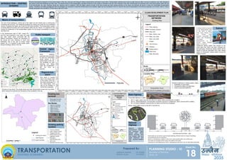
- 1. 4.0000 4.0000 4.0000 4.0000 2.0000 INTRODUCTION – EXISTING SCINARIO Physical development depends on the transit system of the city. Land use and transport related requirements connected to each other. Transportation infrastructure works as rigid structure after it comes in existence even with changes in the nearby constructed buildings and their uses. The present study of the transportation resulted increment in the number of vehicles in the city. Auto rickshaw is the main vehicle plays an important role in the transit system within the city. in the last decade, car, auto, rickshaw, tempo etc. became more in existence. With the higher rational number of the fast running and slow running vehicles on the same rout became the barrier in safe and comfortable transportation system. Therefore, the traffic management with the strategies are required to make this infrastructure more suitable. Ujjain city has considered 1510 hc. Area for the use of transportation in the future proposals, out of which, 825 hc. Area is already developed and rest 685 hc. Of the area is still not in uses. Railway State Highway National Highway Existing bus terminal Public transport Means of transportation 17 A railway station proposed in the development plan of the 2021, in which, Kothi road, Dewas road and Vikram nagar properly connected with station and Pingleshwar sub-station. The development of the Vikram nagar Railway station is required. Three state highway in Ujjain- SH-17, Ujjain Jawra road, join from SH-31 to Jawra, which connects NH-3 at Mahu SH-18 – Dewas-Badnavar, connects NH-3 at Dewas and SH-31 to Badnavar, which connects NH-3 at Mahu. SH -27 Indore Jhalawad, connects NH-3 at Indore and NH-52 at Jhalawad. Mostly, Heavy traffic occurs on the SH-27 and SH-18, The size of the buildings in central part of the Ujjain city and nearby area is continuously increasing with the time. The residential buildings are majorly use under the non-residential activity. It resulting the higher use of land for the transit activities. The transportation system is directly affects economic and social activities within the city. Hence, it is required to look forward for betterment of the transportation system for the proper accessibility in present and future too. In the development plan of 1991, mainly RI-1, and RI-2 has proposed in the major city roads and other roads, which connected with the different workplaces. People are dependent on the tempo and auto rickshaw to reach their destination due to the lack of proper transit system. So, it is required to give proper public transport strategy criteria in the city. National Highway Development Authority has proposed Ujjain Garoth part, which affects planning area from Eastern side and Ujjain Badnavar part from Southern-western side. EXISTING ROAD SECTIONS – 18M Some roads are can not be a part of road widening, informal sector or shops or buildings encroached the part of road lanes. Section is showing the condition of the main roads located within the market area, The roads are occupied, which reduce the width of the roads, Proposals for road widening are there in development plan but it can not take place practically, • Dewas gate bus stop • Nankhede bus stop Bus Routes • Ujjain to mandsaur • Ujjain to neemuch • Ujjain to jaora • Ujjain to Indore • Ujjain to bhilwara Dushhara Maidan Ujjain railways station Freeganj CBD area Makshi Road near by vegetable market Bharatpuri Administrative area Kothi Area Mahakal restriction area Existing parking location of buses on bus stand. The private buses and state transportation buses use to go there, which reduces the pollution and frequency of the accidents in the city. Central region Framework Road widening proposals have provided for fast and comfortable transit system in the central region of the city. The proposals for road widening are taking under the consideration with the time as required. Regional bus stand Bus stand is located near to the Dewas Gate In the center of the city. Bus stand developed on the Indore-Ujjain road with all the facilities to reduce the congestion Chintaman railway station was located on the meter gaze line, which has been changed into the brad gaze. Chintaman railway station will be helpful to shift the population from main railway station to Chintaman railway station during the religious events. Problems observed on railway station, Ujjain – Availability of clean water, Unorganized sitting arrangements, Under constructed platforms TRANSPORTATION PLANNING STUDIO - VI Bachelor of Planning 2018 - 22 18 Sheet No. EXISTING SCENARIO Prepared By: 2035 HARSHITA BAMNE RIZWAN ALAM 181109004 181109037 mTtSu fodkl ifj;kstuk