1) The Pacific Islands Fisheries Science Center is mapping benthic habitats around 55 islands and atolls in the U.S.-Affiliated Pacific Islands using multibeam sonar and optical groundtruthing to characterize coral reef ecosystems.
2) From 2002-2007, multibeam mapping was conducted around the Northwestern Hawaiian Islands, Main Hawaiian Islands, Commonwealth of the Northern Mariana Islands, American Samoa, and Pacific Remote Island Areas.
3) In 2008-2009, priority areas for additional mapping include French Frigate Shoals and Pearl and Hermes Reef in the Northwestern Hawaiian Islands to fill gaps in existing data.
The Challenges for the Palawan Biosphere Reserve in Dealing with Climate ChangeNo to mining in Palawan
The Challenges for the Palawan Biosphere Reserve in Dealing with Climate Change
Forum on Climate Change for the Province of Palawan
The Legend Hotel, Puerto Princesa City
19 June 2009
Romeo B. Dorado
OIC-Executive Director
Palawan Council for Sustainable Development Staff
The extension of the CS may be considered as a legal polar challenge. Legal, because it directly involves the rights recognized by UNCLOS, from coast to open sea. Challenge, because its exploitation could be related to discussion regarding the definition of a balance in the management of these marine areas and the will to improve protection. However, its specific assessment varies depending on institutional development that Polar Regions are subject to, evolution that marks the analysis and interpretation of the Polar Submissions....
Presentation by Tony Kimmet from the USDA Natural Resource Conservation Service (NRCS); review and update of orthoimagery resources available for Hawaii and the Pacific
From the Arctic to the Tropics: The U.S. UNCLOS Bathymetric Mapping ProgramLarry Mayer
Since CHC2006, the University of New Hampshire’s Center for Coastal & Ocean Mapping/Joint Hydrographic Center has mapped with multibeam, the bathymetry of an additional ~220,000 km2 of seafloor in areas as diverse as the Arctic, the Northern Marianas of the western Pacific and the Gulf of Mexico. The mapping supports any potential U.S. submission for of extended continental shelves under Article 76 of the United Nations Convention of the Law of the Sea. Consequently, the mapping has concentrated on capturing the complete extent of the 2500-m isobath and the zone where the Article 76-defined foot of the slope exists. In practice, the complete area between ~1500 and ~4500 m water depths is mapped in each region (with the exception of the Arctic Ocean). The data have been collected in conditions that range from harsh Arctic sea ice to the calms of the Philippine Sea tropics. Although, some of the conditions have limited the quality of some of the data, the data quality is generally quite good and geological surprises have been uncovered on each of the cruises.
CLIMATE CHANGE, SEA-LEVEL RISE and COASTAL GEOLOGIC HAZARDSriseagrant
CLIMATE CHANGE, SEA-LEVEL RISE
and
COASTAL GEOLOGIC HAZARDS
URI Climate Change Symposium
5 May 2011
Jon C. Boothroyd
Rhode Island State Geologist,
Research Professor Emeritus – Quaternary Geology
-------------
Rhode Island Geological Survey and Department of Geosciences
College of the Environment and Life Sciences
University of Rhode Island
jon_boothroyd@uri.edu
Pushing the limits of ePRTC: 100ns holdover for 100 daysAdtran
At WSTS 2024, Alon Stern explored the topic of parametric holdover and explained how recent research findings can be implemented in real-world PNT networks to achieve 100 nanoseconds of accuracy for up to 100 days.
Threats to mobile devices are more prevalent and increasing in scope and complexity. Users of mobile devices desire to take full advantage of the features
available on those devices, but many of the features provide convenience and capability but sacrifice security. This best practices guide outlines steps the users can take to better protect personal devices and information.
Encryption in Microsoft 365 - ExpertsLive Netherlands 2024Albert Hoitingh
In this session I delve into the encryption technology used in Microsoft 365 and Microsoft Purview. Including the concepts of Customer Key and Double Key Encryption.
Enchancing adoption of Open Source Libraries. A case study on Albumentations.AIVladimir Iglovikov, Ph.D.
Presented by Vladimir Iglovikov:
- https://www.linkedin.com/in/iglovikov/
- https://x.com/viglovikov
- https://www.instagram.com/ternaus/
This presentation delves into the journey of Albumentations.ai, a highly successful open-source library for data augmentation.
Created out of a necessity for superior performance in Kaggle competitions, Albumentations has grown to become a widely used tool among data scientists and machine learning practitioners.
This case study covers various aspects, including:
People: The contributors and community that have supported Albumentations.
Metrics: The success indicators such as downloads, daily active users, GitHub stars, and financial contributions.
Challenges: The hurdles in monetizing open-source projects and measuring user engagement.
Development Practices: Best practices for creating, maintaining, and scaling open-source libraries, including code hygiene, CI/CD, and fast iteration.
Community Building: Strategies for making adoption easy, iterating quickly, and fostering a vibrant, engaged community.
Marketing: Both online and offline marketing tactics, focusing on real, impactful interactions and collaborations.
Mental Health: Maintaining balance and not feeling pressured by user demands.
Key insights include the importance of automation, making the adoption process seamless, and leveraging offline interactions for marketing. The presentation also emphasizes the need for continuous small improvements and building a friendly, inclusive community that contributes to the project's growth.
Vladimir Iglovikov brings his extensive experience as a Kaggle Grandmaster, ex-Staff ML Engineer at Lyft, sharing valuable lessons and practical advice for anyone looking to enhance the adoption of their open-source projects.
Explore more about Albumentations and join the community at:
GitHub: https://github.com/albumentations-team/albumentations
Website: https://albumentations.ai/
LinkedIn: https://www.linkedin.com/company/100504475
Twitter: https://x.com/albumentations
Essentials of Automations: The Art of Triggers and Actions in FMESafe Software
In this second installment of our Essentials of Automations webinar series, we’ll explore the landscape of triggers and actions, guiding you through the nuances of authoring and adapting workspaces for seamless automations. Gain an understanding of the full spectrum of triggers and actions available in FME, empowering you to enhance your workspaces for efficient automation.
We’ll kick things off by showcasing the most commonly used event-based triggers, introducing you to various automation workflows like manual triggers, schedules, directory watchers, and more. Plus, see how these elements play out in real scenarios.
Whether you’re tweaking your current setup or building from the ground up, this session will arm you with the tools and insights needed to transform your FME usage into a powerhouse of productivity. Join us to discover effective strategies that simplify complex processes, enhancing your productivity and transforming your data management practices with FME. Let’s turn complexity into clarity and make your workspaces work wonders!
UiPath Test Automation using UiPath Test Suite series, part 5DianaGray10
Welcome to UiPath Test Automation using UiPath Test Suite series part 5. In this session, we will cover CI/CD with devops.
Topics covered:
CI/CD with in UiPath
End-to-end overview of CI/CD pipeline with Azure devops
Speaker:
Lyndsey Byblow, Test Suite Sales Engineer @ UiPath, Inc.
Goodbye Windows 11: Make Way for Nitrux Linux 3.5.0!SOFTTECHHUB
As the digital landscape continually evolves, operating systems play a critical role in shaping user experiences and productivity. The launch of Nitrux Linux 3.5.0 marks a significant milestone, offering a robust alternative to traditional systems such as Windows 11. This article delves into the essence of Nitrux Linux 3.5.0, exploring its unique features, advantages, and how it stands as a compelling choice for both casual users and tech enthusiasts.
The Art of the Pitch: WordPress Relationships and SalesLaura Byrne
Clients don’t know what they don’t know. What web solutions are right for them? How does WordPress come into the picture? How do you make sure you understand scope and timeline? What do you do if sometime changes?
All these questions and more will be explored as we talk about matching clients’ needs with what your agency offers without pulling teeth or pulling your hair out. Practical tips, and strategies for successful relationship building that leads to closing the deal.
GraphSummit Singapore | The Future of Agility: Supercharging Digital Transfor...Neo4j
Leonard Jayamohan, Partner & Generative AI Lead, Deloitte
This keynote will reveal how Deloitte leverages Neo4j’s graph power for groundbreaking digital twin solutions, achieving a staggering 100x performance boost. Discover the essential role knowledge graphs play in successful generative AI implementations. Plus, get an exclusive look at an innovative Neo4j + Generative AI solution Deloitte is developing in-house.
Unlocking Productivity: Leveraging the Potential of Copilot in Microsoft 365, a presentation by Christoforos Vlachos, Senior Solutions Manager – Modern Workplace, Uni Systems
GraphRAG is All You need? LLM & Knowledge GraphGuy Korland
Guy Korland, CEO and Co-founder of FalkorDB, will review two articles on the integration of language models with knowledge graphs.
1. Unifying Large Language Models and Knowledge Graphs: A Roadmap.
https://arxiv.org/abs/2306.08302
2. Microsoft Research's GraphRAG paper and a review paper on various uses of knowledge graphs:
https://www.microsoft.com/en-us/research/blog/graphrag-unlocking-llm-discovery-on-narrative-private-data/
DevOps and Testing slides at DASA ConnectKari Kakkonen
My and Rik Marselis slides at 30.5.2024 DASA Connect conference. We discuss about what is testing, then what is agile testing and finally what is Testing in DevOps. Finally we had lovely workshop with the participants trying to find out different ways to think about quality and testing in different parts of the DevOps infinity loop.
zkStudyClub - Reef: Fast Succinct Non-Interactive Zero-Knowledge Regex ProofsAlex Pruden
This paper presents Reef, a system for generating publicly verifiable succinct non-interactive zero-knowledge proofs that a committed document matches or does not match a regular expression. We describe applications such as proving the strength of passwords, the provenance of email despite redactions, the validity of oblivious DNS queries, and the existence of mutations in DNA. Reef supports the Perl Compatible Regular Expression syntax, including wildcards, alternation, ranges, capture groups, Kleene star, negations, and lookarounds. Reef introduces a new type of automata, Skipping Alternating Finite Automata (SAFA), that skips irrelevant parts of a document when producing proofs without undermining soundness, and instantiates SAFA with a lookup argument. Our experimental evaluation confirms that Reef can generate proofs for documents with 32M characters; the proofs are small and cheap to verify (under a second).
Paper: https://eprint.iacr.org/2023/1886
Removing Uninteresting Bytes in Software FuzzingAftab Hussain
Imagine a world where software fuzzing, the process of mutating bytes in test seeds to uncover hidden and erroneous program behaviors, becomes faster and more effective. A lot depends on the initial seeds, which can significantly dictate the trajectory of a fuzzing campaign, particularly in terms of how long it takes to uncover interesting behaviour in your code. We introduce DIAR, a technique designed to speedup fuzzing campaigns by pinpointing and eliminating those uninteresting bytes in the seeds. Picture this: instead of wasting valuable resources on meaningless mutations in large, bloated seeds, DIAR removes the unnecessary bytes, streamlining the entire process.
In this work, we equipped AFL, a popular fuzzer, with DIAR and examined two critical Linux libraries -- Libxml's xmllint, a tool for parsing xml documents, and Binutil's readelf, an essential debugging and security analysis command-line tool used to display detailed information about ELF (Executable and Linkable Format). Our preliminary results show that AFL+DIAR does not only discover new paths more quickly but also achieves higher coverage overall. This work thus showcases how starting with lean and optimized seeds can lead to faster, more comprehensive fuzzing campaigns -- and DIAR helps you find such seeds.
- These are slides of the talk given at IEEE International Conference on Software Testing Verification and Validation Workshop, ICSTW 2022.
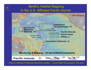
1. Benthic Habitat Mapping
1
In the U.S.-Affiliated Pacific Islands
U.S.-Affiliated
* Tide Gauges
* (18)
***
*
Wake Island **
* (24) Pacific Remote
Island Areas
(PRIA) (7)
*
*
* (6)
Monitoring & Mapping ~55 Island/Atoll Ecosystems
Pacific Islands Fisheries Science Center – Coral Reef Ecosystem Division
2. 2
U.S. Coral Reef Task Force Goal
Produce comprehensive digital
maps of all shallow (<30m)
coral reef ecosystems in the
United States and characterize
priority moderate-depth reef
systems by 2009.
5. 5 PIFSC-CRED Mapping in American Samoa – 2004 & 2006
Tutuila Ofu and Olosega
Ta′u
Rose
Atoll
Swains
Island
6. 6 MHI Data Synthesis
PIFSC/CRED and Univ. of Hawaii
Shallow (15-300 m)
Shallow (15-300 m) Unmapped areas include
high resolution
high resolution harbor surveys and gaps
NOAA surveys
NOAA surveys between LIDAR and
2005-2006:
2005-2006: multibeam bathymetry
Ni′ihau, Kohala,
Ni′ihau, Kohala, Ni′ihau
Penguin Bank,
Penguin Bank, N. Shore
N. Shore Moloka′i
N. Shore Moloka′i Moloka′i
Kohala
Penguin Big Island
Bank
50-m grid available at http://www.soest.hawaii.edu/hmrg/Multibeam/explorer.php
50- grid available at http://www.soest.hawaii.edu/hmrg/Multibeam/explorer.php
50-m http://www.soest.hawaii.edu/hmrg/Multibeam/explorer.php
7. 7
PIFSC/CRED
Multibeam Data Collected
in NWHI 2002-2006
Gaps include ~ 9,000 km2 of banktop
(15-100 m) areas and most of the deep water
(15-
seafloor (> 100 m) within the boundaries of the
Papahā naumokuā
Papahānaumokuākea Marine National Monument
8. 8 Multibeam Data Collected in CNMI and Guam: 2003-2007
Maug Pagan
Saipan, Tinian
and Rota Harbors
surveyed to
IHO standards in
2007 using R/V AHI Guam
in collaboration
with OCS,
U.S. Navy and
CNMI Port
Authority.
Tinian
Aguijan
Areas that still need multibeam
surveys are circled in black
9. Bathymetry
Bathymetry
9 gaps
gaps
Baker Jarvis
Pacific Remote
Pacific Remote
Island Areas
Island Areas
2006
2006
10. 10 PIFSC-CRED Multibeam Mapping
PIFSC-CRED
at Wake Island -- 2007
11. 11 Bathymetric Mapping Completion
• Many areas completely mapped in 20-1000 m.
20-1000
• Guam, Rota, and Aguijan 15-300 m ~ 1 month
15-300
• Kingman & Johnston 15-50 m ~ 1 week
15-50
• MHI
– Harbor surveys using R/V AHI are currently under
discussion with NOAA Office of Coast Survey (OCS)
– Areas between LIDAR and deeper multibeam
coverage could be mapped with R/V AHI ~ 3-6 mos.
3-6
Need mandate and support from other mgmt. groups.
• NWHI
– ~9,000 km2 of bank tops (15-100 m) remain
2 (15-100
~ 10-20 years at 15-30 days/yr.
10-20 15-30
– Deep (> 100 m) mapping in MNM ~ 2 mos.
• LIDAR could be used in most areas in < 30 m
12. 12 Key Mapping •
• Pacific Consortium of Undersea
Pacific Consortium of Undersea
Habitat Centers (proposed)
Partnerships •
• CNMI and Guam
CNMI and Guam
–
– U.S. Navy
U.S. Navy
–
– NOAA Office of Coast Survey
NOAA Office of Coast Survey
–
– CNMI Port Authority
CNMI Port Authority
–
– National Park Service
National Park Service
–
– U.S. Geological Survey
U.S. Geological Survey
–
– Guam Fisherman’s Co-op
Guam Fisherman’ Co-
Fisherman’s Co-op
–
– University of Guam
University of Guam
•
• Hawaiian Archipelago
Hawaiian Archipelago
–
– Papahānaumokuā
Papahānaumokuākea MNM
–
– Div. of Land & Natural Resources
Div. of Land & Natural Resources
–
– U.S. Fish and Wildlife Service
U.S. Fish and Wildlife Service
–
– University of Hawaii – HMRG, HURL
University of Hawaii – HMRG, HURL
–
– NOAA Office of Coast Survey
NOAA Office of Coast Survey
–
– NOAA Pacific Services Center
NOAA Pacific Services Center
•
• American Samoa
American Samoa
– National Park Service
– NOAA National Marine Sanctuaries
•
• PRIA
PRIA
– U.S. Fish and Wildlife Service
Saipan Anchorage Habitat
– U.S. Air Force
– U.S. Air Force
Survey for U.S. Navy in 2004
13. 2008 - 2009 Mapping Priorities and Acitivities
13 Pacific Islands Fisheries Science Center
Coral Reef Ecosystem Division (CRED)
30-day April/May cruise aboard Hi’ialakai using 25’ R/V AHI survey launch is the only
scheduled mapping cruise in the Papahānaumokuākea Marine National Monument
(PMNM) in three field seasons (2007-2009). Multibeam and optical validation data
will be collected at French Frigate Shoals and Pearl and Hermes Reef as first priority.
If time allows, surveys may also be done at St. Rogatien bank or Nihoa Island.
14. 14 French Frigate Shoals
Existing Multibeam, IKONOS, and Optical Validation Data
Yellow circles indicate
areas scheduled for
multibeam mapping
on May 2008 cruise.
Optical validation data
will also be collected.
15. Pearl and Hermes Reef
Existing Multibeam, IKONOS, and Optical Validation Data
Yellow circles indicate
15 areas scheduled for
multibeam mapping
on May 2008 cruise.
Optical validation data
will also be collected.
collected.
16. IKONOS or Land Sat Imagery
A Layered
Multibeam Bathymetry GIS Approach
& Estimated Depths
Multibeam
to Benthic
Backscatter Habitat Mapping
Slope
Rugosity
Bathymetric
Appropriate Position Index
layers used for
supervised and
unsupervised Integrated
classifications: Arc GIS
e.g. hard/soft
Projects
Optical Data
and Linked
Positions
16
17. 17 Multibeam Data Products,
Standards and Issues
•
• Data collected using standard hydrographic techniques and equipment with
Data collected using standard hydrographic techniques and equipment with
documented calibrations
–
– Few tide stations
Few tide stations
–
– No DGPS in most areas until 2007 (NavCom)
No DGPS in most areas until 2007 (NavCom)
(NavCom)
–
– Much more (10-20 x) expensive to collect all data to IHO standards because of
Much more (10-
(10-20 x) expensive to collect all data to IHO standards because of
bottom coverage requirements and documentation required to meet IHO standards
•
• Multibeam swath data in generic sensor format submitted to NGDC within one
Multibeam swath data in generic sensor format submitted to NGDC within one
year of collection
year of collection
– Request from State of Hawaii to not make Main Hawaiian Island data in 100-500 m
– Request from State of Hawaii to not make Main Hawaiian Island data in 100-
data 100-500 m
depths available to public because of Essential Fish Habitat concerns
concerns
– Metadata creation very time consuming and as yet no “standard” for multibeam
standard”
– Metadata creation very time consuming and as yet no “standard” for multibeam
format – this needs to be automated
– Much of data is in areas with pre-WWII soundings, but is not being or will not be
– Much of data is in areas with pre-
pre-WWII soundings, but is not being or will not be
used for nautical chart updates
•
• Gridded bathymetric and backscatter data products (with metadata) available
Gridded bathymetric and backscatter data products (with metadata) available
on web at www.soest.hawaii.edu/pibhmc within one year
– Metadata produced for all products, time consuming & needs automation
automation
– Metadata sent to Coral Reef Information System (CoRIS) site
(CoRIS)
18. 18
Moderate Depth Optical Data
• Existing coverage is limited
• Need much more data
• Data collection
–
– Time consuming
Time consuming
–
– Inaccurate positioning
Inaccurate positioning
–
– Difficult in rugged coral areas
Difficult in rugged coral areas
–
– Need to use more sophisticated
Need to use more sophisticated
technique (e.g., terrain-
following AUV)
following AUV)
• Data processing
– Interpretation techniques
– Integration with other data
compromised because of
positioning issues
positioning issues
– Metadata, no standards
– Time intensive, automation?
19. 19 Habitat Mapping Challenges
Shallow water habitats (<~15 m)
Need bathymetry and backscatter
LIDAR works well, but not accessible in remote areas
Moderate depth habitats (~15 – 400 m)
Very sparse biological cover information
Terrain-following AUV for optical validation needed
Terrain-following
Integration of shallow and deep mapping
Shallow maps based on optical imagery, lack structure
Moderate maps based on acoustic mapping, lack biology
Need seamless mapping products
Need Habitat Utilization Maps
Which organisms utilize which habitats