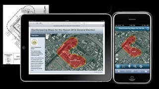
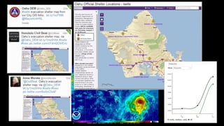
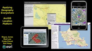
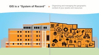
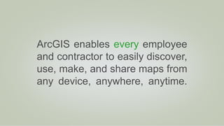
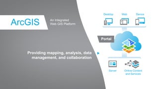
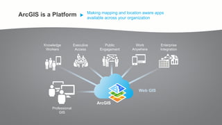
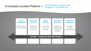
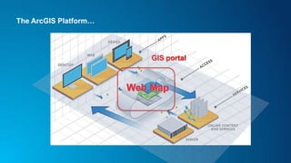
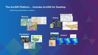
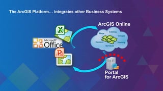
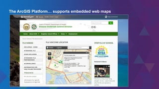
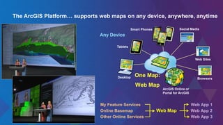
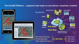
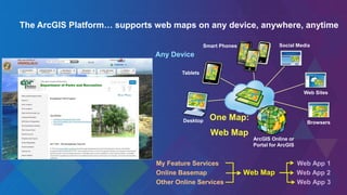
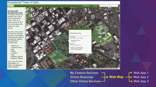
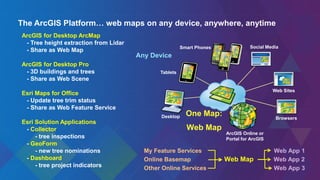
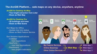
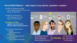
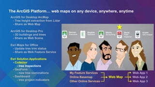
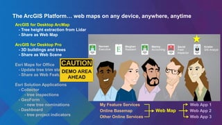
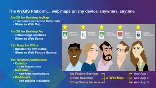
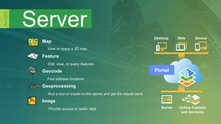
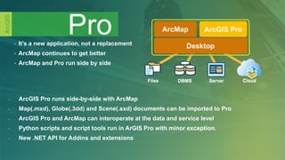
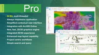
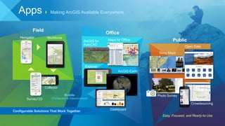
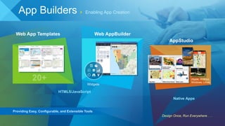
SlideShare a Scribd company logo
1 of 57
Download to read offline
Applying
Geography
Everywhere
ArcGIS
Location
Platform
Royce Jones
Rod Low
Craig Clouet
Dan Haag
Facility Networks
Roads
Property Records
Land Use
Environmental
Considerations
Imagery
Social Factors
Applying
Geography
Everywhere
ArcGIS
Location
Platform
Royce Jones
Rod Low
Craig Clouet
Dan Haag
GIS is a “System of Record” Organizing and managing the geographic
context of your assets and resources
Is that authoritative knowledge
reaching the entire workforce?
Increased Demand For authoritative mapping and location-aware apps at work
Pew Research Center
74% of adults use their smartphone to get directions or other information based on their current location
At Work People Want…
one
corporate
system
no user
limitations
3-clicks
or less
uniformity
in all
their maps
as easy
to use as
their iPhone
Applying Geography Everywhere
Vision
DevicesSocial Apps
58%
Own a
Smartphone
2.8
Devices Owned by
Knowledge Workers
87%
Using the
Internet
ArcGIS enables every employee
and contractor to easily discover,
use, make, and share maps from
any device, anywhere, anytime.
Providing mapping, analysis, data
management, and collaboration
An Integrated
Web GIS PlatformArcGIS
Desktop Web Device
Server Online Content
and Services
Portal
ArcGIS is a Platform Making mapping and location aware apps
available across your organization
ArcGIS
Knowledge
Workers
Professional
GIS
Work
Anywhere
Public
Engagement
Executive
Access
Enterprise
Integration
Web GIS
Kristin
Human Resources
Identity Your “key” to accessing the ArcGIS Platform wherever you are
Naveen
Executive
Meghan
IT
Manny
Accounting
David
Field
Ops
Kristin
Human
Resources
Collaboration Enable people to work together by securely
sharing data, apps, and knowledge
Providing mapping, analysis, data
management, and collaboration
Asset
Management
ArcGIS — Integrated Web GIS Platform
Planning &
Analysis
Field
Mobility
Operational
Awareness
Constituent
Engagement
Transform data
into actionable
information
Collect, organize,
and exchange data
Get information
into and out
of the field
Disseminate
information where
and when it
is needed
Get feedback
and make
informed decisions
A Complete Location Platform
The ArcGIS Platform…
GIS portaln
The ArcGIS Platform… includes ArcGIS for Desktop
Authoring authoritative content…
Editor
Tom
Bill
Joe
Editing
Analysis
Mapping
½ Mile¼ Mile 1 Mile
Visualization
ArcGIS Online
Content
Catalog
Groups
Hosting
Maps
Services
Portal
for ArcGIS
The ArcGIS Platform… integrates other Business Systems
The ArcGIS Platform… supports embedded web maps
One Map:
Web Map
Desktop
Tablets
Smart Phones
Web Sites
ArcGIS Online or
Portal for ArcGIS
Any Device
Browsers
Social Media
The ArcGIS Platform… supports web maps on any device, anywhere, anytime
My Feature Services Web App 1
Online Basemap Web Map Web App 2
Other Online Services Web App 3
INTERNATIONAL SCIENCE AND ENGINEERING FAIR
One Map:
Web Map
Desktop
Tablets
Smart Phones
Web Sites
ArcGIS Online or
Portal for ArcGIS
Any Device
Browsers
Social Media
The ArcGIS Platform… supports web maps on any device, anywhere, anytime
My Feature Services Web App 1
Online Basemap Web Map Web App 2
Other Online Services Web App 3
The ArcGIS Platform… supports web maps on any device, anywhere, anytime
One Map:
Web Map
Desktop
Tablets
Smart Phones
Web Sites
ArcGIS Online or
Portal for ArcGIS
Any Device
Browsers
Social Media
My Feature Services Web App 1
Online Basemap Web Map Web App 2
Other Online Services Web App 3
The ArcGIS Platform… supports web maps on any device, anywhere, anytime
One Map:
Web Map
Desktop
Tablets
Smart Phones
Web Sites
ArcGIS Online or
Portal for ArcGIS
Any Device
Browsers
Social Media
My Feature Services Web App 1
Online Basemap Web Map Web App 2
Other Online Services Web App 3
My Feature Services Web App 1
Online Basemap Web Map Web App 2
Other Online Services Web App 3
One Map:
Web Map
Desktop
Tablets
Smart Phones
Web Sites
ArcGIS Online or
Portal for ArcGIS
Any Device
Browsers
Social Media
The ArcGIS Platform… web maps on any device, anywhere, anytime
ArcGIS for Desktop ArcMap
- Tree height extraction from Lidar
- Share as Web Map
ArcGIS for Desktop Pro
- 3D buildings and trees
- Share as Web Scene
Esri Maps for Office
- Update tree trim status
- Share as Web Feature Service
Esri Solution Applications
- Collector
- tree inspections
- GeoForm
- new tree nominations
- Dashboard
- tree project indicators
My Feature Services Web App 1
Online Basemap Web Map Web App 2
Other Online Services Web App 3
The ArcGIS Platform… web maps on any device, anywhere, anytime
ArcGIS for Desktop ArcMap
- Tree height extraction from Lidar
- Publish Web Map
ArcGIS for Desktop Pro
- 3D buildings and trees
- Publish Web Scene
Esri Maps for Office
- Update tree trim status
- Share as Web Feature Service
Esri Solution Applications
- Collector
- tree inspections
- GeoForm
- new tree nominations
- Dashboard
- tree project indicators
My Feature Services Web App 1
Online Basemap Web Map Web App 2
Other Online Services Web App 3
The ArcGIS Platform… web maps on any device, anywhere, anytime
ArcGIS for Desktop ArcMap
- Tree height extraction from Lidar
- Share as Web Map
ArcGIS for Desktop Pro
- 3D buildings and trees
- Share as Web Scene
Esri Maps for Office
- Update tree trim status
- Share as Web Feature Service
Esri Solution Applications
- Collector
- tree inspections
- GeoForm
- new tree nominations
- Dashboard
- tree project indicators
My Feature Services Web App 1
Online Basemap Web Map Web App 2
Other Online Services Web App 3
The ArcGIS Platform… web maps on any device, anywhere, anytime
ArcGIS for Desktop ArcMap
- Tree height extraction from Lidar
- Share as Web Map
ArcGIS for Desktop Pro
- 3D buildings and trees
- Share as Web Scene
Esri Maps for Office
- Update tree trim status
- Share as Web Feature Service
Esri Solution Applications
- Collector
- tree inspections
- GeoForm
- new tree nominations
- Dashboard
- tree project indicators
One Map:
Web Map
Desktop
Tablets
Smart Phones
Web Sites
ArcGIS Online or
Portal for ArcGIS
Any Device
Browsers
Social Media
My Feature Services Web App 1
Online Basemap Web Map Web App 2
Other Online Services Web App 3
Applying
Geography
Everywhere
ArcGIS
Location
Platform
Questions?
Royce Jones
Rod Low
Craig Clouet
Dan Haag My Feature Services Web App 1
Online Basemap Web Map Web App 2
Other Online Services Web App 3
Server
ArcGIS
Map
View or query a 2D map
Feature
Edit, view, or query features
Geocode
Find address locations
Geoprocessing
Run a tool or model on the server and get the results back
Image
Provide access to raster data
Desktop Web Device
Server Online Content
and Services
Portal
Pro
ArcGIS
• It’s a new application, not a replacement
• ArcMap continues to get better
• ArcMap and Pro run side by side
Cloud
ArcGIS Pro
Desktop
ArcMap
Desktop
Files DBMS ServerFiles DBMS Server Cloud
Desktop
ArcMap
Desktop
- ArcGIS Pro runs side-by-side with ArcMap
- Map(.mxd), Globe(.3dd) and Scene(.sxd) documents can be imported to Pro
- ArcGIS Pro and ArcMap can interoperate at the data and service level
- Python scripts and script tools run in ArGIS Pro with minor exception.
- New .NET API for Addins and extensions
• 64 Bit, multi-threaded
• Always responsive application
• Simplified contextual user interface
• Integration with ArcGIS Online
• New, fast, 2D/3D graphics engine
• Integrated 2D/3D experience
• Enhanced map layout capability
• Project centric workflows
• Simple search and query
Pro
ArcGIS
Training in Honolulu March 21-22, 2016
• ArcGIS Pro: Instructor-Led Classroom
Pro
ArcGIS
Field
Office
Public
Easy, Focused, and Ready-to-Use
Apps Making ArcGIS Available Everywhere
Story Maps
Open Data
Crowdsourcing
Photo Survey
Maps for OfficeArcGIS for
AutoCAD
Configurable Solutions That Work Together
Mobile
(Connected & Disconnected)
Navigator
Collector
Survey123
Workforce
Explorer
ArcGIS Earth
Dashboard
Enabling App Creation
Design Once, Run Everywhere . . .
Widgets
Web AppBuilder
AppStudio
(Apple, Android,
Windows, Linux)
Web App Templates
HTML5/JavaScript
Native Apps
Providing Easy, Configurable, and Extensible Tools
App Builders
Instructor-Led and Self-Paced
Classroom and Online
Learn Online
Honolulu Classroom
Instructor-Led and Self-Paced
Classroom and Online
Learn Online
Honolulu Classroom
My Feature Services Web App 1
Online Basemap Web Map Web App 2
Other Online Services Web App 3
Applying
Geography
Everywhere
ArcGIS
Location
Platform
Royce Jones
Rod Low
Craig Clouet
Dan Haag

More Related Content

What's hot

Esriuk_track5_pro_launch
Esriuk_track5_pro_launchEsriuk_track5_pro_launch
Esriuk_track5_pro_launchEsri UK
 
Architecting the ArcGIS Platform
Architecting the ArcGIS PlatformArchitecting the ArcGIS Platform
Architecting the ArcGIS PlatformEsri UK
 
Introduction to ArcGIS for Developers, Esri, Charles van der Put, Jim Barry
Introduction toArcGIS for Developers, Esri, Charles van der Put, Jim BarryIntroduction toArcGIS for Developers, Esri, Charles van der Put, Jim Barry
Introduction to ArcGIS for Developers, Esri, Charles van der Put, Jim BarryEsri Nederland
 
Esri Ireland "ArcGIS - The Platform Story" Roadmap Session - Eamonn Doyle, Es...
Esri Ireland "ArcGIS - The Platform Story" Roadmap Session - Eamonn Doyle, Es...Esri Ireland "ArcGIS - The Platform Story" Roadmap Session - Eamonn Doyle, Es...
Esri Ireland "ArcGIS - The Platform Story" Roadmap Session - Eamonn Doyle, Es...Esri Ireland
 
NDGeospatialSummit2019 - ArcGIS Pro – Next-Generation Desktop GIS
NDGeospatialSummit2019 - ArcGIS Pro – Next-Generation Desktop GISNDGeospatialSummit2019 - ArcGIS Pro – Next-Generation Desktop GIS
NDGeospatialSummit2019 - ArcGIS Pro – Next-Generation Desktop GISNorth Dakota GIS Hub
 
Getting Started with the ArcGIS API for JavaScript, Esri, Julie Powell, Antoo...
Getting Started with the ArcGIS API for JavaScript, Esri, Julie Powell, Antoo...Getting Started with the ArcGIS API for JavaScript, Esri, Julie Powell, Antoo...
Getting Started with the ArcGIS API for JavaScript, Esri, Julie Powell, Antoo...Esri Nederland
 
NDGeospatialSummit2019 - ArcGIS Enterprise – Power Your Location Intelligence
NDGeospatialSummit2019 - ArcGIS Enterprise – Power Your Location IntelligenceNDGeospatialSummit2019 - ArcGIS Enterprise – Power Your Location Intelligence
NDGeospatialSummit2019 - ArcGIS Enterprise – Power Your Location IntelligenceNorth Dakota GIS Hub
 
NDGeospatialSummit2019 - What’s New with ArcGIS – Highlights From the 2019 UC
NDGeospatialSummit2019 - What’s New with ArcGIS – Highlights From the 2019 UC NDGeospatialSummit2019 - What’s New with ArcGIS – Highlights From the 2019 UC
NDGeospatialSummit2019 - What’s New with ArcGIS – Highlights From the 2019 UC North Dakota GIS Hub
 
Esri 2016 User Conference - ArcGIS Online steps for success
Esri 2016 User Conference - ArcGIS Online steps for successEsri 2016 User Conference - ArcGIS Online steps for success
Esri 2016 User Conference - ArcGIS Online steps for successBern Szukalski
 
Esriuk_track5_mobile_solutions
Esriuk_track5_mobile_solutionsEsriuk_track5_mobile_solutions
Esriuk_track5_mobile_solutionsEsri UK
 
ArcGIS API for Javascript Tutorial
ArcGIS API for Javascript TutorialArcGIS API for Javascript Tutorial
ArcGIS API for Javascript TutorialMohammed Mahmoud
 
Licensing in ArcGIS 10.0 and 10.1
Licensing in ArcGIS 10.0 and 10.1Licensing in ArcGIS 10.0 and 10.1
Licensing in ArcGIS 10.0 and 10.1Esri South Africa
 
Enterprise Audit Tracking at CenterPoint Energy, Show Me the Edits!
Enterprise Audit Tracking at CenterPoint Energy, Show Me the Edits!Enterprise Audit Tracking at CenterPoint Energy, Show Me the Edits!
Enterprise Audit Tracking at CenterPoint Energy, Show Me the Edits!SSP Innovations
 
Developing a Weather Forecasting Web-Service using ArcGIS API for JavaScript
Developing a Weather Forecasting Web-Service using ArcGIS API for JavaScriptDeveloping a Weather Forecasting Web-Service using ArcGIS API for JavaScript
Developing a Weather Forecasting Web-Service using ArcGIS API for JavaScriptAlexa Guertin
 
Esri South Africa ArcGIS 10.2 Rollout
Esri South Africa ArcGIS 10.2 Rollout Esri South Africa ArcGIS 10.2 Rollout
Esri South Africa ArcGIS 10.2 Rollout Esri South Africa
 
NDGISUC2017 - Introducing ArcGIS Pro
NDGISUC2017 - Introducing ArcGIS ProNDGISUC2017 - Introducing ArcGIS Pro
NDGISUC2017 - Introducing ArcGIS ProNorth Dakota GIS Hub
 
Web Editing in ArcGIS Server
Web Editing in ArcGIS ServerWeb Editing in ArcGIS Server
Web Editing in ArcGIS ServerEsri
 
Taking Advantage of ArcGIS Online to Push a Mobile Agenda
Taking Advantage of ArcGIS Online to Push a Mobile AgendaTaking Advantage of ArcGIS Online to Push a Mobile Agenda
Taking Advantage of ArcGIS Online to Push a Mobile AgendaMichael Olkin
 
ArcGIS JavaScript API (build a web layer-based map application with html5 and...
ArcGIS JavaScript API (build a web layer-based map application with html5 and...ArcGIS JavaScript API (build a web layer-based map application with html5 and...
ArcGIS JavaScript API (build a web layer-based map application with html5 and...Stefano Marchisio
 

What's hot (20)

Esriuk_track5_pro_launch
Esriuk_track5_pro_launchEsriuk_track5_pro_launch
Esriuk_track5_pro_launch
 
Architecting the ArcGIS Platform
Architecting the ArcGIS PlatformArchitecting the ArcGIS Platform
Architecting the ArcGIS Platform
 
Introduction to ArcGIS for Developers, Esri, Charles van der Put, Jim Barry
Introduction toArcGIS for Developers, Esri, Charles van der Put, Jim BarryIntroduction toArcGIS for Developers, Esri, Charles van der Put, Jim Barry
Introduction to ArcGIS for Developers, Esri, Charles van der Put, Jim Barry
 
Esri Ireland "ArcGIS - The Platform Story" Roadmap Session - Eamonn Doyle, Es...
Esri Ireland "ArcGIS - The Platform Story" Roadmap Session - Eamonn Doyle, Es...Esri Ireland "ArcGIS - The Platform Story" Roadmap Session - Eamonn Doyle, Es...
Esri Ireland "ArcGIS - The Platform Story" Roadmap Session - Eamonn Doyle, Es...
 
NDGeospatialSummit2019 - ArcGIS Pro – Next-Generation Desktop GIS
NDGeospatialSummit2019 - ArcGIS Pro – Next-Generation Desktop GISNDGeospatialSummit2019 - ArcGIS Pro – Next-Generation Desktop GIS
NDGeospatialSummit2019 - ArcGIS Pro – Next-Generation Desktop GIS
 
Getting Started with the ArcGIS API for JavaScript, Esri, Julie Powell, Antoo...
Getting Started with the ArcGIS API for JavaScript, Esri, Julie Powell, Antoo...Getting Started with the ArcGIS API for JavaScript, Esri, Julie Powell, Antoo...
Getting Started with the ArcGIS API for JavaScript, Esri, Julie Powell, Antoo...
 
High Accuracy Data Collection with Esri's Collector App
High Accuracy Data Collection with Esri's Collector AppHigh Accuracy Data Collection with Esri's Collector App
High Accuracy Data Collection with Esri's Collector App
 
NDGeospatialSummit2019 - ArcGIS Enterprise – Power Your Location Intelligence
NDGeospatialSummit2019 - ArcGIS Enterprise – Power Your Location IntelligenceNDGeospatialSummit2019 - ArcGIS Enterprise – Power Your Location Intelligence
NDGeospatialSummit2019 - ArcGIS Enterprise – Power Your Location Intelligence
 
NDGeospatialSummit2019 - What’s New with ArcGIS – Highlights From the 2019 UC
NDGeospatialSummit2019 - What’s New with ArcGIS – Highlights From the 2019 UC NDGeospatialSummit2019 - What’s New with ArcGIS – Highlights From the 2019 UC
NDGeospatialSummit2019 - What’s New with ArcGIS – Highlights From the 2019 UC
 
Esri 2016 User Conference - ArcGIS Online steps for success
Esri 2016 User Conference - ArcGIS Online steps for successEsri 2016 User Conference - ArcGIS Online steps for success
Esri 2016 User Conference - ArcGIS Online steps for success
 
Esriuk_track5_mobile_solutions
Esriuk_track5_mobile_solutionsEsriuk_track5_mobile_solutions
Esriuk_track5_mobile_solutions
 
ArcGIS API for Javascript Tutorial
ArcGIS API for Javascript TutorialArcGIS API for Javascript Tutorial
ArcGIS API for Javascript Tutorial
 
Licensing in ArcGIS 10.0 and 10.1
Licensing in ArcGIS 10.0 and 10.1Licensing in ArcGIS 10.0 and 10.1
Licensing in ArcGIS 10.0 and 10.1
 
Enterprise Audit Tracking at CenterPoint Energy, Show Me the Edits!
Enterprise Audit Tracking at CenterPoint Energy, Show Me the Edits!Enterprise Audit Tracking at CenterPoint Energy, Show Me the Edits!
Enterprise Audit Tracking at CenterPoint Energy, Show Me the Edits!
 
Developing a Weather Forecasting Web-Service using ArcGIS API for JavaScript
Developing a Weather Forecasting Web-Service using ArcGIS API for JavaScriptDeveloping a Weather Forecasting Web-Service using ArcGIS API for JavaScript
Developing a Weather Forecasting Web-Service using ArcGIS API for JavaScript
 
Esri South Africa ArcGIS 10.2 Rollout
Esri South Africa ArcGIS 10.2 Rollout Esri South Africa ArcGIS 10.2 Rollout
Esri South Africa ArcGIS 10.2 Rollout
 
NDGISUC2017 - Introducing ArcGIS Pro
NDGISUC2017 - Introducing ArcGIS ProNDGISUC2017 - Introducing ArcGIS Pro
NDGISUC2017 - Introducing ArcGIS Pro
 
Web Editing in ArcGIS Server
Web Editing in ArcGIS ServerWeb Editing in ArcGIS Server
Web Editing in ArcGIS Server
 
Taking Advantage of ArcGIS Online to Push a Mobile Agenda
Taking Advantage of ArcGIS Online to Push a Mobile AgendaTaking Advantage of ArcGIS Online to Push a Mobile Agenda
Taking Advantage of ArcGIS Online to Push a Mobile Agenda
 
ArcGIS JavaScript API (build a web layer-based map application with html5 and...
ArcGIS JavaScript API (build a web layer-based map application with html5 and...ArcGIS JavaScript API (build a web layer-based map application with html5 and...
ArcGIS JavaScript API (build a web layer-based map application with html5 and...
 

Similar to The ArcGIS Platform: Appyling Geography Everywhere

ArcGIS por
ArcGIS porArcGIS por
ArcGIS porWizoAli
 
Imagery and beyond - BK 2016
Imagery and beyond - BK 2016Imagery and beyond - BK 2016
Imagery and beyond - BK 2016Geodata AS
 
ArcGIS for Desktop
ArcGIS for DesktopArcGIS for Desktop
ArcGIS for DesktopEsri
 
Staging the Enterprise on ArcGIS Online
Staging the Enterprise on ArcGIS OnlineStaging the Enterprise on ArcGIS Online
Staging the Enterprise on ArcGIS OnlineMichael Olkin
 
Esri Mobility Basics 2013
Esri Mobility Basics 2013Esri Mobility Basics 2013
Esri Mobility Basics 2013Esri South Africa
 
0 supermapproductsintroduction
0 supermapproductsintroduction0 supermapproductsintroduction
0 supermapproductsintroductionGeoMedeelel
 
GIS and the Cloud
GIS and the CloudGIS and the Cloud
GIS and the CloudBern Szukalski
 
Argis manual gratuito
Argis manual gratuitoArgis manual gratuito
Argis manual gratuitoluismate
 
ArcGIS Extensions
ArcGIS ExtensionsArcGIS Extensions
ArcGIS ExtensionsEsri
 
Esri user conference highlights v0.2 15072020_hah
Esri user conference highlights v0.2 15072020_hahEsri user conference highlights v0.2 15072020_hah
Esri user conference highlights v0.2 15072020_hahHaitham A.Hamdan
 
GIS as a Platform by Sam Viana (Esri Inc)
GIS as a Platform by Sam Viana (Esri Inc)GIS as a Platform by Sam Viana (Esri Inc)
GIS as a Platform by Sam Viana (Esri Inc)Esri South Africa
 
Esri Location Analytics: Four Implementation Models
Esri Location Analytics: Four Implementation ModelsEsri Location Analytics: Four Implementation Models
Esri Location Analytics: Four Implementation ModelsEsri
 
GeoPlanner for ArcGIS
GeoPlanner for ArcGISGeoPlanner for ArcGIS
GeoPlanner for ArcGISEsri
 
Navteq Developer Days - ArcGIS + POI
Navteq Developer Days - ArcGIS + POINavteq Developer Days - ArcGIS + POI
Navteq Developer Days - ArcGIS + POIAllan Laframboise
 
Virtual Earth And ESRI
Virtual Earth And ESRIVirtual Earth And ESRI
Virtual Earth And ESRITim Warr
 
Scalable Data Analytics and Visualization with Cloud Optimized Services
Scalable Data Analytics and Visualization with Cloud Optimized ServicesScalable Data Analytics and Visualization with Cloud Optimized Services
Scalable Data Analytics and Visualization with Cloud Optimized ServicesGlobus
 

Similar to The ArcGIS Platform: Appyling Geography Everywhere (20)

ArcGIS por
ArcGIS porArcGIS por
ArcGIS por
 
Imagery and beyond - BK 2016
Imagery and beyond - BK 2016Imagery and beyond - BK 2016
Imagery and beyond - BK 2016
 
ArcGIS for Desktop
ArcGIS for DesktopArcGIS for Desktop
ArcGIS for Desktop
 
Day4_WebGIS
Day4_WebGISDay4_WebGIS
Day4_WebGIS
 
Esri Map App Builders
Esri Map App BuildersEsri Map App Builders
Esri Map App Builders
 
Staging the Enterprise on ArcGIS Online
Staging the Enterprise on ArcGIS OnlineStaging the Enterprise on ArcGIS Online
Staging the Enterprise on ArcGIS Online
 
Extension arc gis
Extension arc gisExtension arc gis
Extension arc gis
 
Esri Mobility Basics 2013
Esri Mobility Basics 2013Esri Mobility Basics 2013
Esri Mobility Basics 2013
 
0 supermapproductsintroduction
0 supermapproductsintroduction0 supermapproductsintroduction
0 supermapproductsintroduction
 
GIS and the Cloud
GIS and the CloudGIS and the Cloud
GIS and the Cloud
 
Argis manual gratuito
Argis manual gratuitoArgis manual gratuito
Argis manual gratuito
 
Argis manual gratuito
Argis manual gratuitoArgis manual gratuito
Argis manual gratuito
 
ArcGIS Extensions
ArcGIS ExtensionsArcGIS Extensions
ArcGIS Extensions
 
Esri user conference highlights v0.2 15072020_hah
Esri user conference highlights v0.2 15072020_hahEsri user conference highlights v0.2 15072020_hah
Esri user conference highlights v0.2 15072020_hah
 
GIS as a Platform by Sam Viana (Esri Inc)
GIS as a Platform by Sam Viana (Esri Inc)GIS as a Platform by Sam Viana (Esri Inc)
GIS as a Platform by Sam Viana (Esri Inc)
 
Esri Location Analytics: Four Implementation Models
Esri Location Analytics: Four Implementation ModelsEsri Location Analytics: Four Implementation Models
Esri Location Analytics: Four Implementation Models
 
GeoPlanner for ArcGIS
GeoPlanner for ArcGISGeoPlanner for ArcGIS
GeoPlanner for ArcGIS
 
Navteq Developer Days - ArcGIS + POI
Navteq Developer Days - ArcGIS + POINavteq Developer Days - ArcGIS + POI
Navteq Developer Days - ArcGIS + POI
 
Virtual Earth And ESRI
Virtual Earth And ESRIVirtual Earth And ESRI
Virtual Earth And ESRI
 
Scalable Data Analytics and Visualization with Cloud Optimized Services
Scalable Data Analytics and Visualization with Cloud Optimized ServicesScalable Data Analytics and Visualization with Cloud Optimized Services
Scalable Data Analytics and Visualization with Cloud Optimized Services
 

More from Hawaii Geographic Information Coordinating Council

More from Hawaii Geographic Information Coordinating Council (20)

Taking 3D to the next Level with 3D Streaming Maps
Taking 3D to the next Level with 3D Streaming MapsTaking 3D to the next Level with 3D Streaming Maps
Taking 3D to the next Level with 3D Streaming Maps
 
US Army Real Estate Holdings in Hawaii
US Army Real Estate Holdings in HawaiiUS Army Real Estate Holdings in Hawaii
US Army Real Estate Holdings in Hawaii
 
NOAA's Coastal Change Analysis Program
NOAA's Coastal Change Analysis ProgramNOAA's Coastal Change Analysis Program
NOAA's Coastal Change Analysis Program
 
Hawaii and US Pacific Basin Orthoimagery Update
Hawaii and US Pacific Basin Orthoimagery UpdateHawaii and US Pacific Basin Orthoimagery Update
Hawaii and US Pacific Basin Orthoimagery Update
 
Web based Data and Tools for Coastal Management
Web based Data and Tools for Coastal ManagementWeb based Data and Tools for Coastal Management
Web based Data and Tools for Coastal Management
 
Ecosystem Vulnerability and Cumulative Impacts on th eOceans of hawaii
Ecosystem Vulnerability and Cumulative Impacts on th eOceans of hawaiiEcosystem Vulnerability and Cumulative Impacts on th eOceans of hawaii
Ecosystem Vulnerability and Cumulative Impacts on th eOceans of hawaii
 
Using GIS to Connect Communities
Using GIS to Connect CommunitiesUsing GIS to Connect Communities
Using GIS to Connect Communities
 
Assessing Reef Health Using a Low Altitude Sensing Platform
Assessing Reef Health Using a Low Altitude Sensing PlatformAssessing Reef Health Using a Low Altitude Sensing Platform
Assessing Reef Health Using a Low Altitude Sensing Platform
 
Hawaii DOT Monitoring Stations Versus National Performance Measurement Resear...
Hawaii DOT Monitoring Stations Versus National Performance Measurement Resear...Hawaii DOT Monitoring Stations Versus National Performance Measurement Resear...
Hawaii DOT Monitoring Stations Versus National Performance Measurement Resear...
 
Use of GIS Technology to Inform Planning Efforts Through Visualization of Com...
Use of GIS Technology to Inform Planning Efforts Through Visualization of Com...Use of GIS Technology to Inform Planning Efforts Through Visualization of Com...
Use of GIS Technology to Inform Planning Efforts Through Visualization of Com...
 
Expanding GIS Access to Technical and Non-Technical Users to Enhance Project ...
Expanding GIS Access to Technical and Non-Technical Users to Enhance Project ...Expanding GIS Access to Technical and Non-Technical Users to Enhance Project ...
Expanding GIS Access to Technical and Non-Technical Users to Enhance Project ...
 
STEMworks: K12 Education in Hawaii in Science Technology Engineering and Math
STEMworks: K12 Education in Hawaii in Science Technology Engineering and MathSTEMworks: K12 Education in Hawaii in Science Technology Engineering and Math
STEMworks: K12 Education in Hawaii in Science Technology Engineering and Math
 
Planning for Technological Change
Planning for Technological ChangePlanning for Technological Change
Planning for Technological Change
 
Now & the Future of geodesy in Hawaii for the GIS Users
Now & the Future of geodesy in Hawaii for the GIS UsersNow & the Future of geodesy in Hawaii for the GIS Users
Now & the Future of geodesy in Hawaii for the GIS Users
 
314 woods- uav mapping history
314   woods- uav mapping history314   woods- uav mapping history
314 woods- uav mapping history
 
314 smith 2015 higicc-final
314  smith 2015 higicc-final314  smith 2015 higicc-final
314 smith 2015 higicc-final
 
Real Time Corrections for GNSS Receivers
Real Time Corrections for GNSS ReceiversReal Time Corrections for GNSS Receivers
Real Time Corrections for GNSS Receivers
 
Honolulu Board of Water Supply: Enterprise GIS
Honolulu Board of Water Supply: Enterprise GISHonolulu Board of Water Supply: Enterprise GIS
Honolulu Board of Water Supply: Enterprise GIS
 
State of Hawaii Digital Leveling Project
State of Hawaii Digital Leveling ProjectState of Hawaii Digital Leveling Project
State of Hawaii Digital Leveling Project
 
Urban Tree Canopy Change Assessment for Southern Oahu
Urban Tree Canopy Change Assessment for Southern OahuUrban Tree Canopy Change Assessment for Southern Oahu
Urban Tree Canopy Change Assessment for Southern Oahu
 

Recently uploaded

TrustArc Webinar - Unlock the Power of AI-Driven Data Discovery
TrustArc Webinar - Unlock the Power of AI-Driven Data DiscoveryTrustArc Webinar - Unlock the Power of AI-Driven Data Discovery
TrustArc Webinar - Unlock the Power of AI-Driven Data DiscoveryTrustArc
 
DEV meet-up UiPath Document Understanding May 7 2024 Amsterdam
DEV meet-up UiPath Document Understanding May 7 2024 AmsterdamDEV meet-up UiPath Document Understanding May 7 2024 Amsterdam
DEV meet-up UiPath Document Understanding May 7 2024 AmsterdamUiPathCommunity
 
Polkadot JAM Slides - Token2049 - By Dr. Gavin Wood
Polkadot JAM Slides - Token2049 - By Dr. Gavin WoodPolkadot JAM Slides - Token2049 - By Dr. Gavin Wood
Polkadot JAM Slides - Token2049 - By Dr. Gavin WoodJuan lago vázquez
 
Web Form Automation for Bonterra Impact Management (fka Social Solutions Apri...
Web Form Automation for Bonterra Impact Management (fka Social Solutions Apri...Web Form Automation for Bonterra Impact Management (fka Social Solutions Apri...
Web Form Automation for Bonterra Impact Management (fka Social Solutions Apri...Jeffrey Haguewood
 
Finding Java's Hidden Performance Traps @ DevoxxUK 2024
Finding Java's Hidden Performance Traps @ DevoxxUK 2024Finding Java's Hidden Performance Traps @ DevoxxUK 2024
Finding Java's Hidden Performance Traps @ DevoxxUK 2024Victor Rentea
 
JavaScript Usage Statistics 2024 - The Ultimate Guide
JavaScript Usage Statistics 2024 - The Ultimate GuideJavaScript Usage Statistics 2024 - The Ultimate Guide
JavaScript Usage Statistics 2024 - The Ultimate GuidePixlogix Infotech
 
Platformless Horizons for Digital Adaptability
Platformless Horizons for Digital AdaptabilityPlatformless Horizons for Digital Adaptability
Platformless Horizons for Digital AdaptabilityWSO2
 
"I see eyes in my soup": How Delivery Hero implemented the safety system for ...
"I see eyes in my soup": How Delivery Hero implemented the safety system for ..."I see eyes in my soup": How Delivery Hero implemented the safety system for ...
"I see eyes in my soup": How Delivery Hero implemented the safety system for ...Zilliz
 
Understanding the FAA Part 107 License ..
Understanding the FAA Part 107 License ..Understanding the FAA Part 107 License ..
Understanding the FAA Part 107 License ..Christopher Logan Kennedy
 
AI in Action: Real World Use Cases by Anitaraj
AI in Action: Real World Use Cases by AnitarajAI in Action: Real World Use Cases by Anitaraj
AI in Action: Real World Use Cases by AnitarajAnitaRaj43
 
Less Is More: Utilizing Ballerina to Architect a Cloud Data Platform
Less Is More: Utilizing Ballerina to Architect a Cloud Data PlatformLess Is More: Utilizing Ballerina to Architect a Cloud Data Platform
Less Is More: Utilizing Ballerina to Architect a Cloud Data PlatformWSO2
 
Introduction to use of FHIR Documents in ABDM
Introduction to use of FHIR Documents in ABDMIntroduction to use of FHIR Documents in ABDM
Introduction to use of FHIR Documents in ABDMKumar Satyam
 
Modular Monolith - a Practical Alternative to Microservices @ Devoxx UK 2024
Modular Monolith - a Practical Alternative to Microservices @ Devoxx UK 2024Modular Monolith - a Practical Alternative to Microservices @ Devoxx UK 2024
Modular Monolith - a Practical Alternative to Microservices @ Devoxx UK 2024Victor Rentea
 
Quantum Leap in Next-Generation Computing
Quantum Leap in Next-Generation ComputingQuantum Leap in Next-Generation Computing
Quantum Leap in Next-Generation ComputingWSO2
 
Rising Above_ Dubai Floods and the Fortitude of Dubai International Airport.pdf
Rising Above_ Dubai Floods and the Fortitude of Dubai International Airport.pdfRising Above_ Dubai Floods and the Fortitude of Dubai International Airport.pdf
Rising Above_ Dubai Floods and the Fortitude of Dubai International Airport.pdfOrbitshub
 
WSO2's API Vision: Unifying Control, Empowering Developers
WSO2's API Vision: Unifying Control, Empowering DevelopersWSO2's API Vision: Unifying Control, Empowering Developers
WSO2's API Vision: Unifying Control, Empowering DevelopersWSO2
 
How to Check CNIC Information Online with Pakdata cf
How to Check CNIC Information Online with Pakdata cfHow to Check CNIC Information Online with Pakdata cf
How to Check CNIC Information Online with Pakdata cfdanishmna97
 
Cloud Frontiers: A Deep Dive into Serverless Spatial Data and FME
Cloud Frontiers:  A Deep Dive into Serverless Spatial Data and FMECloud Frontiers:  A Deep Dive into Serverless Spatial Data and FME
Cloud Frontiers: A Deep Dive into Serverless Spatial Data and FMESafe Software
 
Exploring Multimodal Embeddings with Milvus
Exploring Multimodal Embeddings with MilvusExploring Multimodal Embeddings with Milvus
Exploring Multimodal Embeddings with MilvusZilliz
 
ChatGPT and Beyond - Elevating DevOps Productivity
ChatGPT and Beyond - Elevating DevOps ProductivityChatGPT and Beyond - Elevating DevOps Productivity
ChatGPT and Beyond - Elevating DevOps ProductivityVictorSzoltysek
 

Recently uploaded (20)

TrustArc Webinar - Unlock the Power of AI-Driven Data Discovery
TrustArc Webinar - Unlock the Power of AI-Driven Data DiscoveryTrustArc Webinar - Unlock the Power of AI-Driven Data Discovery
TrustArc Webinar - Unlock the Power of AI-Driven Data Discovery
 
DEV meet-up UiPath Document Understanding May 7 2024 Amsterdam
DEV meet-up UiPath Document Understanding May 7 2024 AmsterdamDEV meet-up UiPath Document Understanding May 7 2024 Amsterdam
DEV meet-up UiPath Document Understanding May 7 2024 Amsterdam
 
Polkadot JAM Slides - Token2049 - By Dr. Gavin Wood
Polkadot JAM Slides - Token2049 - By Dr. Gavin WoodPolkadot JAM Slides - Token2049 - By Dr. Gavin Wood
Polkadot JAM Slides - Token2049 - By Dr. Gavin Wood
 
Web Form Automation for Bonterra Impact Management (fka Social Solutions Apri...
Web Form Automation for Bonterra Impact Management (fka Social Solutions Apri...Web Form Automation for Bonterra Impact Management (fka Social Solutions Apri...
Web Form Automation for Bonterra Impact Management (fka Social Solutions Apri...
 
Finding Java's Hidden Performance Traps @ DevoxxUK 2024
Finding Java's Hidden Performance Traps @ DevoxxUK 2024Finding Java's Hidden Performance Traps @ DevoxxUK 2024
Finding Java's Hidden Performance Traps @ DevoxxUK 2024
 
JavaScript Usage Statistics 2024 - The Ultimate Guide
JavaScript Usage Statistics 2024 - The Ultimate GuideJavaScript Usage Statistics 2024 - The Ultimate Guide
JavaScript Usage Statistics 2024 - The Ultimate Guide
 
Platformless Horizons for Digital Adaptability
Platformless Horizons for Digital AdaptabilityPlatformless Horizons for Digital Adaptability
Platformless Horizons for Digital Adaptability
 
"I see eyes in my soup": How Delivery Hero implemented the safety system for ...
"I see eyes in my soup": How Delivery Hero implemented the safety system for ..."I see eyes in my soup": How Delivery Hero implemented the safety system for ...
"I see eyes in my soup": How Delivery Hero implemented the safety system for ...
 
Understanding the FAA Part 107 License ..
Understanding the FAA Part 107 License ..Understanding the FAA Part 107 License ..
Understanding the FAA Part 107 License ..
 
AI in Action: Real World Use Cases by Anitaraj
AI in Action: Real World Use Cases by AnitarajAI in Action: Real World Use Cases by Anitaraj
AI in Action: Real World Use Cases by Anitaraj
 
Less Is More: Utilizing Ballerina to Architect a Cloud Data Platform
Less Is More: Utilizing Ballerina to Architect a Cloud Data PlatformLess Is More: Utilizing Ballerina to Architect a Cloud Data Platform
Less Is More: Utilizing Ballerina to Architect a Cloud Data Platform
 
Introduction to use of FHIR Documents in ABDM
Introduction to use of FHIR Documents in ABDMIntroduction to use of FHIR Documents in ABDM
Introduction to use of FHIR Documents in ABDM
 
Modular Monolith - a Practical Alternative to Microservices @ Devoxx UK 2024
Modular Monolith - a Practical Alternative to Microservices @ Devoxx UK 2024Modular Monolith - a Practical Alternative to Microservices @ Devoxx UK 2024
Modular Monolith - a Practical Alternative to Microservices @ Devoxx UK 2024
 
Quantum Leap in Next-Generation Computing
Quantum Leap in Next-Generation ComputingQuantum Leap in Next-Generation Computing
Quantum Leap in Next-Generation Computing
 
Rising Above_ Dubai Floods and the Fortitude of Dubai International Airport.pdf
Rising Above_ Dubai Floods and the Fortitude of Dubai International Airport.pdfRising Above_ Dubai Floods and the Fortitude of Dubai International Airport.pdf
Rising Above_ Dubai Floods and the Fortitude of Dubai International Airport.pdf
 
WSO2's API Vision: Unifying Control, Empowering Developers
WSO2's API Vision: Unifying Control, Empowering DevelopersWSO2's API Vision: Unifying Control, Empowering Developers
WSO2's API Vision: Unifying Control, Empowering Developers
 
How to Check CNIC Information Online with Pakdata cf
How to Check CNIC Information Online with Pakdata cfHow to Check CNIC Information Online with Pakdata cf
How to Check CNIC Information Online with Pakdata cf
 
Cloud Frontiers: A Deep Dive into Serverless Spatial Data and FME
Cloud Frontiers:  A Deep Dive into Serverless Spatial Data and FMECloud Frontiers:  A Deep Dive into Serverless Spatial Data and FME
Cloud Frontiers: A Deep Dive into Serverless Spatial Data and FME
 
Exploring Multimodal Embeddings with Milvus
Exploring Multimodal Embeddings with MilvusExploring Multimodal Embeddings with Milvus
Exploring Multimodal Embeddings with Milvus
 
ChatGPT and Beyond - Elevating DevOps Productivity
ChatGPT and Beyond - Elevating DevOps ProductivityChatGPT and Beyond - Elevating DevOps Productivity
ChatGPT and Beyond - Elevating DevOps Productivity
 

The ArcGIS Platform: Appyling Geography Everywhere

  • 2.
  • 3. Facility Networks Roads Property Records Land Use Environmental Considerations Imagery Social Factors
  • 4.
  • 5.
  • 6.
  • 7.
  • 8.
  • 9.
  • 10.
  • 12. GIS is a “System of Record” Organizing and managing the geographic context of your assets and resources
  • 13. Is that authoritative knowledge reaching the entire workforce?
  • 14. Increased Demand For authoritative mapping and location-aware apps at work Pew Research Center 74% of adults use their smartphone to get directions or other information based on their current location
  • 15. At Work People Want… one corporate system no user limitations 3-clicks or less uniformity in all their maps as easy to use as their iPhone
  • 18. 58% Own a Smartphone 2.8 Devices Owned by Knowledge Workers 87% Using the Internet
  • 19. ArcGIS enables every employee and contractor to easily discover, use, make, and share maps from any device, anywhere, anytime.
  • 20. Providing mapping, analysis, data management, and collaboration An Integrated Web GIS PlatformArcGIS Desktop Web Device Server Online Content and Services Portal
  • 21. ArcGIS is a Platform Making mapping and location aware apps available across your organization ArcGIS Knowledge Workers Professional GIS Work Anywhere Public Engagement Executive Access Enterprise Integration Web GIS
  • 22. Kristin Human Resources Identity Your “key” to accessing the ArcGIS Platform wherever you are
  • 24. Providing mapping, analysis, data management, and collaboration Asset Management ArcGIS — Integrated Web GIS Platform Planning & Analysis Field Mobility Operational Awareness Constituent Engagement Transform data into actionable information Collect, organize, and exchange data Get information into and out of the field Disseminate information where and when it is needed Get feedback and make informed decisions A Complete Location Platform
  • 26. The ArcGIS Platform… includes ArcGIS for Desktop Authoring authoritative content… Editor Tom Bill Joe Editing Analysis Mapping ½ MileÂĽ Mile 1 Mile Visualization
  • 27. ArcGIS Online Content Catalog Groups Hosting Maps Services Portal for ArcGIS The ArcGIS Platform… integrates other Business Systems
  • 28. The ArcGIS Platform… supports embedded web maps
  • 29. One Map: Web Map Desktop Tablets Smart Phones Web Sites ArcGIS Online or Portal for ArcGIS Any Device Browsers Social Media The ArcGIS Platform… supports web maps on any device, anywhere, anytime My Feature Services Web App 1 Online Basemap Web Map Web App 2 Other Online Services Web App 3
  • 30. INTERNATIONAL SCIENCE AND ENGINEERING FAIR
  • 31.
  • 32.
  • 33. One Map: Web Map Desktop Tablets Smart Phones Web Sites ArcGIS Online or Portal for ArcGIS Any Device Browsers Social Media The ArcGIS Platform… supports web maps on any device, anywhere, anytime My Feature Services Web App 1 Online Basemap Web Map Web App 2 Other Online Services Web App 3
  • 34. The ArcGIS Platform… supports web maps on any device, anywhere, anytime One Map: Web Map Desktop Tablets Smart Phones Web Sites ArcGIS Online or Portal for ArcGIS Any Device Browsers Social Media My Feature Services Web App 1 Online Basemap Web Map Web App 2 Other Online Services Web App 3
  • 35. The ArcGIS Platform… supports web maps on any device, anywhere, anytime One Map: Web Map Desktop Tablets Smart Phones Web Sites ArcGIS Online or Portal for ArcGIS Any Device Browsers Social Media My Feature Services Web App 1 Online Basemap Web Map Web App 2 Other Online Services Web App 3
  • 36.
  • 37.
  • 38. My Feature Services Web App 1 Online Basemap Web Map Web App 2 Other Online Services Web App 3
  • 39. One Map: Web Map Desktop Tablets Smart Phones Web Sites ArcGIS Online or Portal for ArcGIS Any Device Browsers Social Media The ArcGIS Platform… web maps on any device, anywhere, anytime ArcGIS for Desktop ArcMap - Tree height extraction from Lidar - Share as Web Map ArcGIS for Desktop Pro - 3D buildings and trees - Share as Web Scene Esri Maps for Office - Update tree trim status - Share as Web Feature Service Esri Solution Applications - Collector - tree inspections - GeoForm - new tree nominations - Dashboard - tree project indicators My Feature Services Web App 1 Online Basemap Web Map Web App 2 Other Online Services Web App 3
  • 40. The ArcGIS Platform… web maps on any device, anywhere, anytime ArcGIS for Desktop ArcMap - Tree height extraction from Lidar - Share as Web Map ArcGIS for Desktop Pro - 3D buildings and trees - Share as Web Scene Esri Maps for Office - Update tree trim status - Share as Web Feature Service Esri Solution Applications - Collector - tree inspections - GeoForm - new tree nominations - Dashboard - tree project indicators My Feature Services Web App 1 Online Basemap Web Map Web App 2 Other Online Services Web App 3
  • 41. The ArcGIS Platform… web maps on any device, anywhere, anytime ArcGIS for Desktop ArcMap - Tree height extraction from Lidar - Share as Web Map ArcGIS for Desktop Pro - 3D buildings and trees - Share as Web Scene Esri Maps for Office - Update tree trim status - Share as Web Feature Service Esri Solution Applications - Collector - tree inspections - GeoForm - new tree nominations - Dashboard - tree project indicators My Feature Services Web App 1 Online Basemap Web Map Web App 2 Other Online Services Web App 3
  • 42. The ArcGIS Platform… web maps on any device, anywhere, anytime ArcGIS for Desktop ArcMap - Tree height extraction from Lidar - Share as Web Map ArcGIS for Desktop Pro - 3D buildings and trees - Share as Web Scene Esri Maps for Office - Update tree trim status - Share as Web Feature Service Esri Solution Applications - Collector - tree inspections - GeoForm - new tree nominations - Dashboard - tree project indicators My Feature Services Web App 1 Online Basemap Web Map Web App 2 Other Online Services Web App 3
  • 43. The ArcGIS Platform… web maps on any device, anywhere, anytime ArcGIS for Desktop ArcMap - Tree height extraction from Lidar - Share as Web Map ArcGIS for Desktop Pro - 3D buildings and trees - Share as Web Scene Esri Maps for Office - Update tree trim status - Share as Web Feature Service Esri Solution Applications - Collector - tree inspections - GeoForm - new tree nominations - Dashboard - tree project indicators My Feature Services Web App 1 Online Basemap Web Map Web App 2 Other Online Services Web App 3
  • 44. The ArcGIS Platform… web maps on any device, anywhere, anytime ArcGIS for Desktop ArcMap - Tree height extraction from Lidar - Publish Web Map ArcGIS for Desktop Pro - 3D buildings and trees - Publish Web Scene Esri Maps for Office - Update tree trim status - Share as Web Feature Service Esri Solution Applications - Collector - tree inspections - GeoForm - new tree nominations - Dashboard - tree project indicators My Feature Services Web App 1 Online Basemap Web Map Web App 2 Other Online Services Web App 3
  • 45. The ArcGIS Platform… web maps on any device, anywhere, anytime ArcGIS for Desktop ArcMap - Tree height extraction from Lidar - Share as Web Map ArcGIS for Desktop Pro - 3D buildings and trees - Share as Web Scene Esri Maps for Office - Update tree trim status - Share as Web Feature Service Esri Solution Applications - Collector - tree inspections - GeoForm - new tree nominations - Dashboard - tree project indicators My Feature Services Web App 1 Online Basemap Web Map Web App 2 Other Online Services Web App 3
  • 46. The ArcGIS Platform… web maps on any device, anywhere, anytime ArcGIS for Desktop ArcMap - Tree height extraction from Lidar - Share as Web Map ArcGIS for Desktop Pro - 3D buildings and trees - Share as Web Scene Esri Maps for Office - Update tree trim status - Share as Web Feature Service Esri Solution Applications - Collector - tree inspections - GeoForm - new tree nominations - Dashboard - tree project indicators My Feature Services Web App 1 Online Basemap Web Map Web App 2 Other Online Services Web App 3
  • 47. The ArcGIS Platform… web maps on any device, anywhere, anytime ArcGIS for Desktop ArcMap - Tree height extraction from Lidar - Share as Web Map ArcGIS for Desktop Pro - 3D buildings and trees - Share as Web Scene Esri Maps for Office - Update tree trim status - Share as Web Feature Service Esri Solution Applications - Collector - tree inspections - GeoForm - new tree nominations - Dashboard - tree project indicators One Map: Web Map Desktop Tablets Smart Phones Web Sites ArcGIS Online or Portal for ArcGIS Any Device Browsers Social Media My Feature Services Web App 1 Online Basemap Web Map Web App 2 Other Online Services Web App 3
  • 48. Applying Geography Everywhere ArcGIS Location Platform Questions? Royce Jones Rod Low Craig Clouet Dan Haag My Feature Services Web App 1 Online Basemap Web Map Web App 2 Other Online Services Web App 3
  • 49. Server ArcGIS Map View or query a 2D map Feature Edit, view, or query features Geocode Find address locations Geoprocessing Run a tool or model on the server and get the results back Image Provide access to raster data Desktop Web Device Server Online Content and Services Portal
  • 50. Pro ArcGIS • It’s a new application, not a replacement • ArcMap continues to get better • ArcMap and Pro run side by side Cloud ArcGIS Pro Desktop ArcMap Desktop Files DBMS ServerFiles DBMS Server Cloud Desktop ArcMap Desktop - ArcGIS Pro runs side-by-side with ArcMap - Map(.mxd), Globe(.3dd) and Scene(.sxd) documents can be imported to Pro - ArcGIS Pro and ArcMap can interoperate at the data and service level - Python scripts and script tools run in ArGIS Pro with minor exception. - New .NET API for Addins and extensions
  • 51. • 64 Bit, multi-threaded • Always responsive application • Simplified contextual user interface • Integration with ArcGIS Online • New, fast, 2D/3D graphics engine • Integrated 2D/3D experience • Enhanced map layout capability • Project centric workflows • Simple search and query Pro ArcGIS
  • 52. Training in Honolulu March 21-22, 2016 • ArcGIS Pro: Instructor-Led Classroom Pro ArcGIS
  • 53. Field Office Public Easy, Focused, and Ready-to-Use Apps Making ArcGIS Available Everywhere Story Maps Open Data Crowdsourcing Photo Survey Maps for OfficeArcGIS for AutoCAD Configurable Solutions That Work Together Mobile (Connected & Disconnected) Navigator Collector Survey123 Workforce Explorer ArcGIS Earth Dashboard
  • 54. Enabling App Creation Design Once, Run Everywhere . . . Widgets Web AppBuilder AppStudio (Apple, Android, Windows, Linux) Web App Templates HTML5/JavaScript Native Apps Providing Easy, Configurable, and Extensible Tools App Builders
  • 55. Instructor-Led and Self-Paced Classroom and Online Learn Online Honolulu Classroom
  • 56. Instructor-Led and Self-Paced Classroom and Online Learn Online Honolulu Classroom My Feature Services Web App 1 Online Basemap Web Map Web App 2 Other Online Services Web App 3