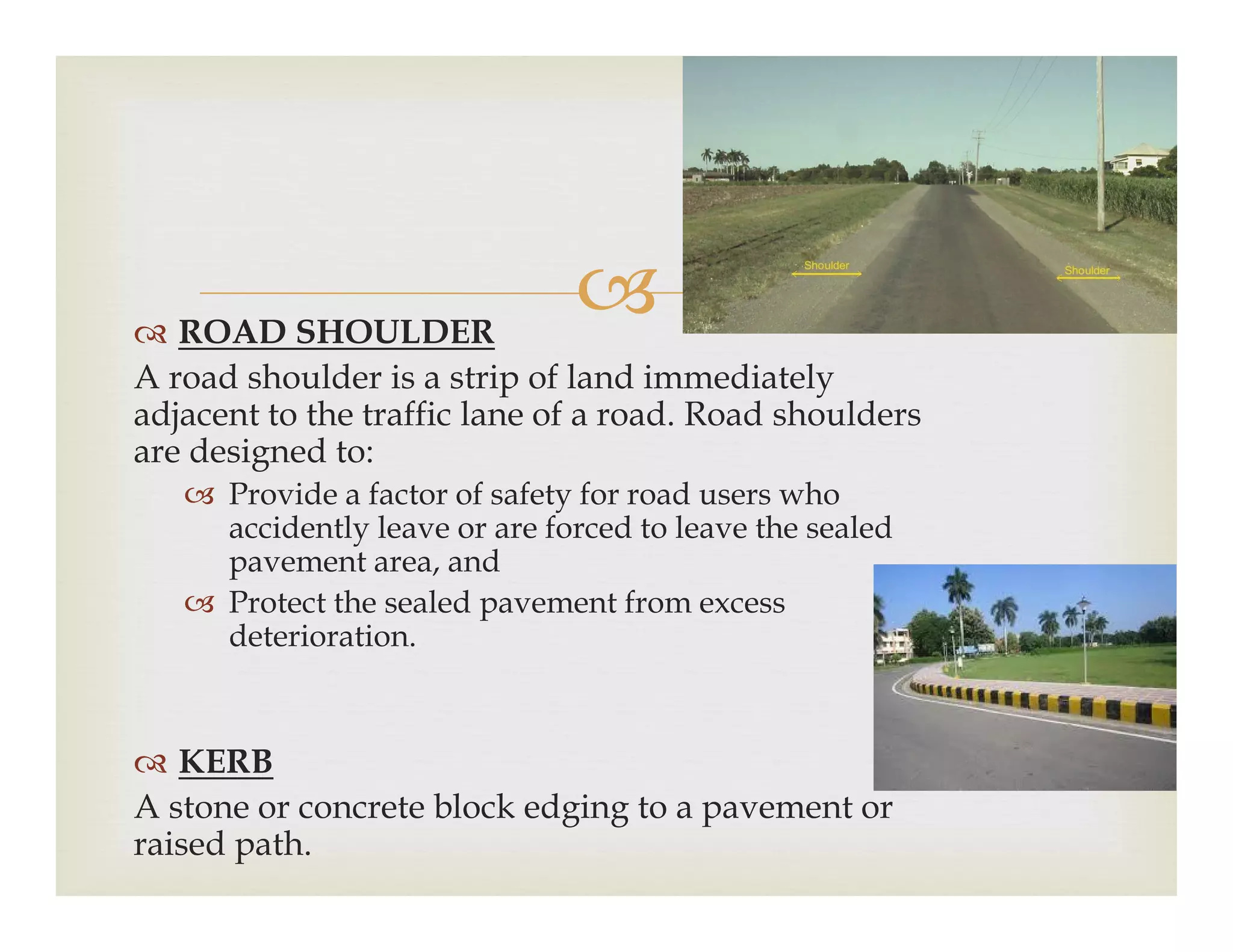
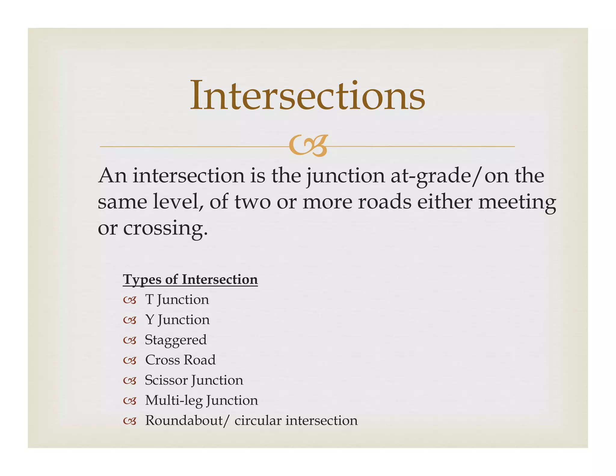
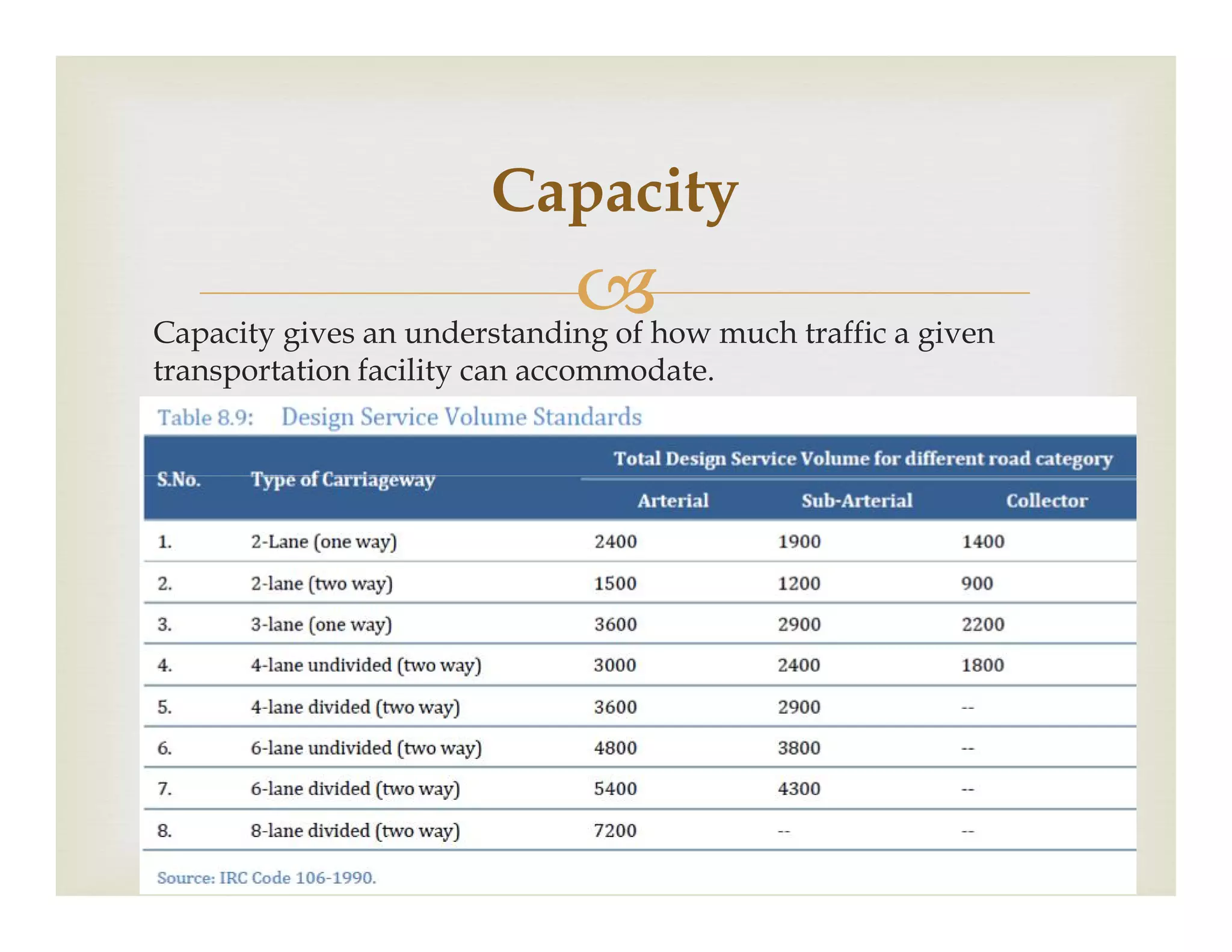
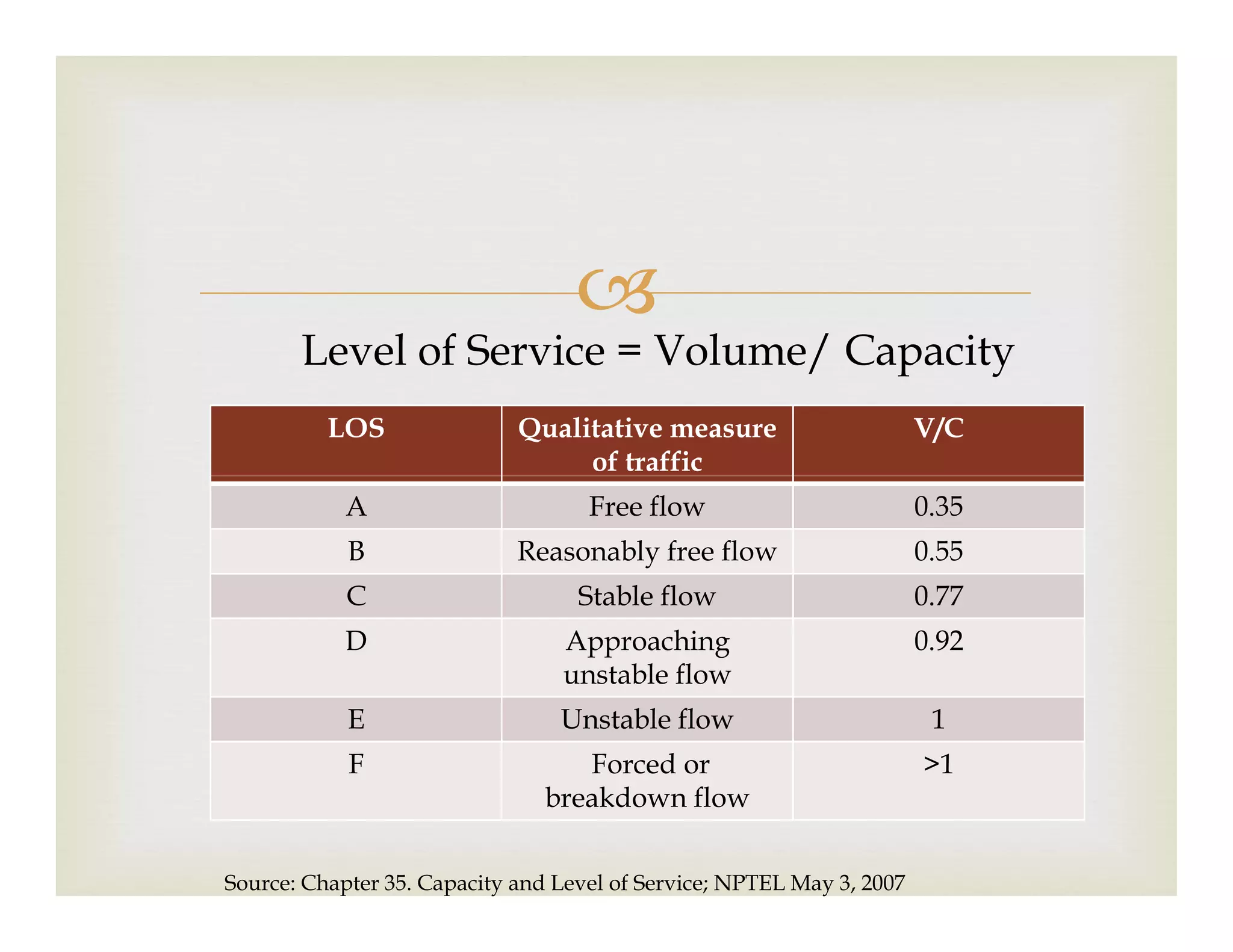
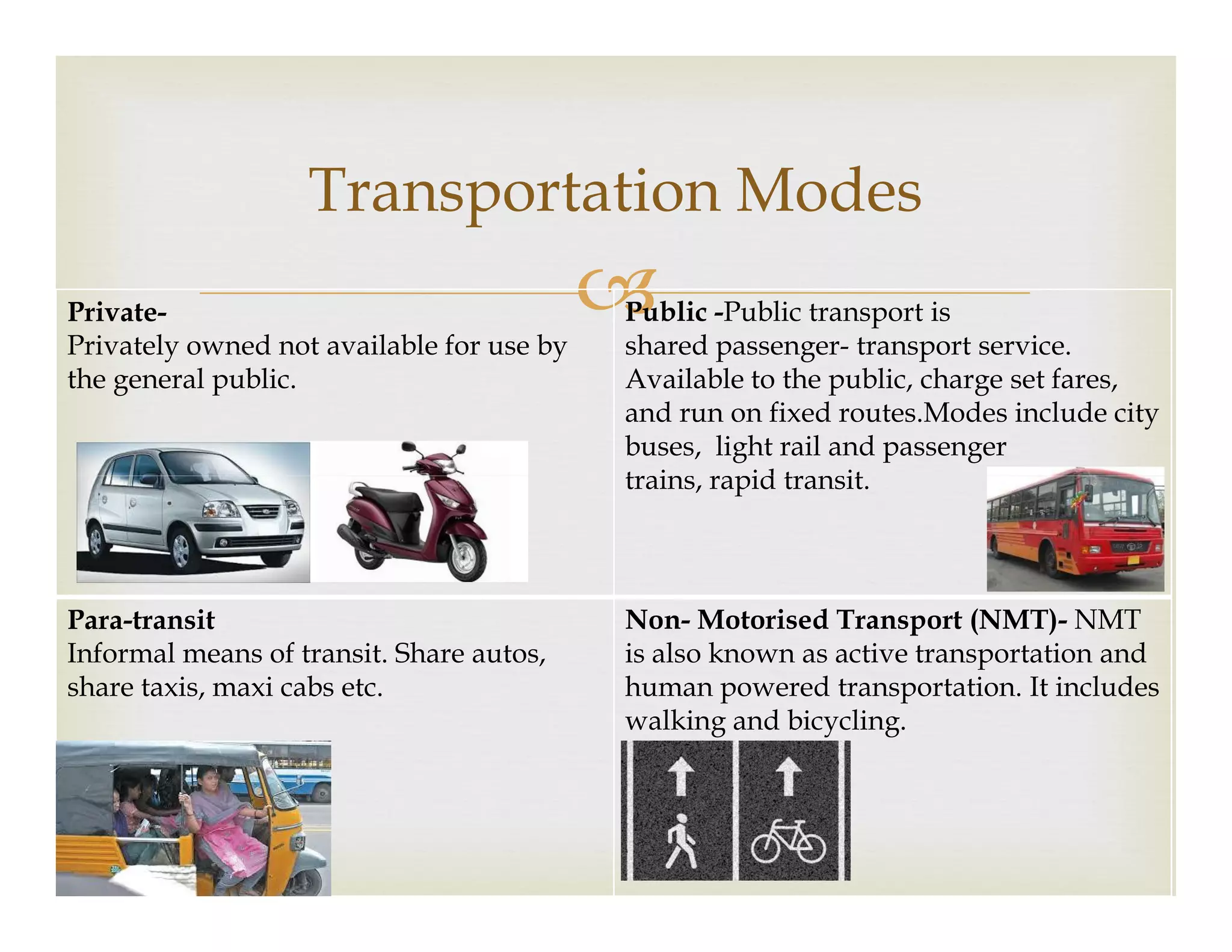
Dhwani ShahDhwani Shah
Assistant ProfessorAssistant Professor
Bhaikaka Centre for Human SettlementsBhaikaka Centre for Human Settlements
APIED, V.V. NagarAPIED, V.V. Nagar
dhwani.shah@apied.edu.indhwani.shah@apied.edu.in

 What is a Transportation System?
 Road Hierarchy
 Common Terms -Road Section
Contents
 Common Terms -Road Section
 Intersections
 Traffic Flow/Volume
 Capacity & Level of Service
 Transportation Modes

What is a Transportation System?
 Network of physical components that help in the
transportation of goods and people from one place to
another.
 Physical components can be referred to as the Physical components can be referred to as the
facilities. It comprises of
 fixed infrastructure
 flow entities
 control system

Physical Infrastructure
 Physical components of the system fixed in space
 Links
(road network, railway network, etc)(road network, railway network, etc)
 Nodes
(junctions, interchanges, bus stops, railway stations)

Flow Entities
 Units that traverse (travel across/through) the fixed facilities -
vehicles, trains
 Road system has to accommodate a wide variety of vehicle types
 CyclesCycles
 Pedestrians
 Cars
 2 wheelers
 Tempo
 Trucks
 Hand rickshaw
 Tractor-trailer

Control System
Means which are required for the efficient and smooth
operation of streams of vehicles and the reduction of
conflicts between vehicles.
 Signage
 Street Markings
 Signal systems
 Expressways
 Arterial Streets
 Sub-arterial Streets
 Collector Streets
ROAD HIERARCHY
 Collector Streets
 Local Streets
 Access Streets
EXPRESSWAYS
 Controlled access
 Grade separated at
junctions
 High traffic volume at
ARTERIAL STREETS
 Principal network for
through traffic
 Restricted access from
carriageway to the side High traffic volume at
high speeds
 Trips of medium and
long lengths
 Eg: Ahmedabad-
Vadodara Expressway
 Essential that they are
continuous
 Connect CBD and suburban
areas
 Parking restricted
 Eg: Chikodara Choki-
Ganesh-Janta-karamsad Road
SUB-ARTERIAL STREETS
 Emphasis on connecting to
adjoining areas
 May be divided or
COLLECTOR STREETS
 Collects and distributes
traffic from local streets
and provides access to
Sub-arterial/ Arterial
 May be divided or
undivided
 Signalized at intersections
with arterial streets
 Parking restricted and
controlled
Sub-arterial/ Arterial
streets
 Generally undivided; may
be divided in some cases
 Less parking restrictions;
some in peak hour
LOCAL STREETS
 Intended for local use on
which through traffic is to
be discouraged.
Unrestricted parking
ACCESS STREETS
 These are used for access
functions to adjoining
properties and areas.
 Unrestricted parking  A majority of trips in
urban areas usually
originate or terminate on
these streets.
 Unrestricted parking

Design Speed and Space Standards
Sr.
No.
Road Types Design Speed
(kmph)
Space
Standards (m)
1 Urban Expressway 80 50-60
2 Arterial Road 50 50-80
3 Sub-Arterial Road 50 30-50
4 Distributor/ Collector Road 30 12-30
5 Local Street 10-20 12-20
6 Access Street 15 6-15
Source: URDPFI Guidelines, 2014. Ministry of Urban Development
 RIGHT OF WAY
 The road width available for public purpose.
 It is the width between properties on opposite sides in the
public domain.
COMMON TERMS (ROAD)
public domain.
 It will include all elements that make up the cross section of
the street (bitumen top, central verge, lighting, parking,
footpath, shoulder etc.)
 CARRIAGEWAY
 A carriageway is the main track of a road or a street, also
known as roadway, driveway or carriage track.
 Commonly referred to as ‘black top’ or ‘bitumen top

Road Section
 ROAD SHOULDER
A road shoulder is a strip of land immediately
adjacent to the traffic lane of a road. Road shoulders
are designed to:
Provide a factor of safety for road users who Provide a factor of safety for road users who
accidently leave or are forced to leave the sealed
pavement area, and
 Protect the sealed pavement from excess
deterioration.
 KERB
A stone or concrete block edging to a pavement or
raised path.
 FOOTPATH
 A footpath is a pedestrian route, that is intended for
pedestrian walking use and from which other forms of
traffic are excluded and prohibitedtraffic are excluded and prohibited
 Generally found on the street edge
 STREET FURNITURE
Street furniture is a collective term for objects and pieces of
equipment installed on streets and roads for various purposes,
including traffic barriers, benches, bollards, post boxes, phone
boxes, street lamps, traffic lights, traffic signs, bus stops, taxi
stands, public lavatories, fountains, statues, and waste bins

An intersection is the junction at-grade/on the
same level, of two or more roads either meeting
or crossing.
Intersections
or crossing.
Types of Intersection
 T Junction
 Y Junction
 Staggered
 Cross Road
 Scissor Junction
 Multi-leg Junction
 Roundabout/ circular intersection

ROUNDABOUT

Traffic Flow/Volume
 Number of vehicles which pass a specified point on
the road over a specified time.
 Vehicles/hour
 Passenger Car Unit (PCU’s)/hour
Also called Passenger Car Equivalent (PCE)
 Annual Average Daily Traffic (AADT)/day
Passenger car units (PCU) of different types of vehicles are required to
convert a mixed traffic stream into a homogeneous equivalent, and
thereby to express the mixed traffic flow in terms of equivalent number of
passenger cars.
Passenger Car Unit (PCU)
Source: URDPFI Guidelines, 2014. Ministry of Urban Development
Capacity gives an understanding of how much traffic a given
transportation facility can accommodate.
Capacity

 Level of service tries to answer how good is the present
traffic situation on a given facility. Thus it gives a
qualitative measure of traffic, where as capacity analysis
gives a quantitative measure of a facility.
Level of Service
gives a quantitative measure of a facility.
 For a given road or facility, capacity could be constant.
But actual flow will be different for different days and
different times in a day itself. The intention of LOS is to
relate the traffic service quality to a given flow rate of
traffic.

LOS Qualitative measure
of traffic
V/C
Level of Service = Volume/ Capacity
of traffic
A Free flow 0.35
B Reasonably free flow 0.55
C Stable flow 0.77
D Approaching
unstable flow
0.92
E Unstable flow 1
F Forced or
breakdown flow
>1
Source: Chapter 35. Capacity and Level of Service; NPTEL May 3, 2007

Transportation Modes
Private-
Privately owned not available for use by
the general public.
Public -Public transport is
shared passenger- transport service.
Available to the public, charge set fares,
and run on fixed routes.Modes include city
buses, light rail and passenger
trains, rapid transit.trains, rapid transit.
Para-transit
Informal means of transit. Share autos,
share taxis, maxi cabs etc.
Non- Motorised Transport (NMT)- NMT
is also known as active transportation and
human powered transportation. It includes
walking and bicycling.

Basics of transportation planning

  • 1.
    Dhwani ShahDhwani Shah AssistantProfessorAssistant Professor Bhaikaka Centre for Human SettlementsBhaikaka Centre for Human Settlements APIED, V.V. NagarAPIED, V.V. Nagar dhwani.shah@apied.edu.indhwani.shah@apied.edu.in
  • 2.
      What isa Transportation System?  Road Hierarchy  Common Terms -Road Section Contents  Common Terms -Road Section  Intersections  Traffic Flow/Volume  Capacity & Level of Service  Transportation Modes
  • 3.
     What is aTransportation System?  Network of physical components that help in the transportation of goods and people from one place to another.  Physical components can be referred to as the Physical components can be referred to as the facilities. It comprises of  fixed infrastructure  flow entities  control system
  • 4.
     Physical Infrastructure  Physicalcomponents of the system fixed in space  Links (road network, railway network, etc)(road network, railway network, etc)  Nodes (junctions, interchanges, bus stops, railway stations)
  • 5.
     Flow Entities  Unitsthat traverse (travel across/through) the fixed facilities - vehicles, trains  Road system has to accommodate a wide variety of vehicle types  CyclesCycles  Pedestrians  Cars  2 wheelers  Tempo  Trucks  Hand rickshaw  Tractor-trailer
  • 6.
     Control System Means whichare required for the efficient and smooth operation of streams of vehicles and the reduction of conflicts between vehicles.  Signage  Street Markings  Signal systems
  • 7.
     Expressways  ArterialStreets  Sub-arterial Streets  Collector Streets ROAD HIERARCHY  Collector Streets  Local Streets  Access Streets
  • 8.
    EXPRESSWAYS  Controlled access Grade separated at junctions  High traffic volume at ARTERIAL STREETS  Principal network for through traffic  Restricted access from carriageway to the side High traffic volume at high speeds  Trips of medium and long lengths  Eg: Ahmedabad- Vadodara Expressway  Essential that they are continuous  Connect CBD and suburban areas  Parking restricted  Eg: Chikodara Choki- Ganesh-Janta-karamsad Road
  • 9.
    SUB-ARTERIAL STREETS  Emphasison connecting to adjoining areas  May be divided or COLLECTOR STREETS  Collects and distributes traffic from local streets and provides access to Sub-arterial/ Arterial  May be divided or undivided  Signalized at intersections with arterial streets  Parking restricted and controlled Sub-arterial/ Arterial streets  Generally undivided; may be divided in some cases  Less parking restrictions; some in peak hour
  • 10.
    LOCAL STREETS  Intendedfor local use on which through traffic is to be discouraged. Unrestricted parking ACCESS STREETS  These are used for access functions to adjoining properties and areas.  Unrestricted parking  A majority of trips in urban areas usually originate or terminate on these streets.  Unrestricted parking
  • 11.
     Design Speed andSpace Standards Sr. No. Road Types Design Speed (kmph) Space Standards (m) 1 Urban Expressway 80 50-60 2 Arterial Road 50 50-80 3 Sub-Arterial Road 50 30-50 4 Distributor/ Collector Road 30 12-30 5 Local Street 10-20 12-20 6 Access Street 15 6-15 Source: URDPFI Guidelines, 2014. Ministry of Urban Development
  • 12.
     RIGHT OFWAY  The road width available for public purpose.  It is the width between properties on opposite sides in the public domain. COMMON TERMS (ROAD) public domain.  It will include all elements that make up the cross section of the street (bitumen top, central verge, lighting, parking, footpath, shoulder etc.)  CARRIAGEWAY  A carriageway is the main track of a road or a street, also known as roadway, driveway or carriage track.  Commonly referred to as ‘black top’ or ‘bitumen top
  • 13.
  • 14.
     ROAD SHOULDER Aroad shoulder is a strip of land immediately adjacent to the traffic lane of a road. Road shoulders are designed to: Provide a factor of safety for road users who Provide a factor of safety for road users who accidently leave or are forced to leave the sealed pavement area, and  Protect the sealed pavement from excess deterioration.  KERB A stone or concrete block edging to a pavement or raised path.
  • 15.
     FOOTPATH  Afootpath is a pedestrian route, that is intended for pedestrian walking use and from which other forms of traffic are excluded and prohibitedtraffic are excluded and prohibited  Generally found on the street edge  STREET FURNITURE Street furniture is a collective term for objects and pieces of equipment installed on streets and roads for various purposes, including traffic barriers, benches, bollards, post boxes, phone boxes, street lamps, traffic lights, traffic signs, bus stops, taxi stands, public lavatories, fountains, statues, and waste bins
  • 16.
     An intersection isthe junction at-grade/on the same level, of two or more roads either meeting or crossing. Intersections or crossing. Types of Intersection  T Junction  Y Junction  Staggered  Cross Road  Scissor Junction  Multi-leg Junction  Roundabout/ circular intersection
  • 23.
  • 24.
     Traffic Flow/Volume  Numberof vehicles which pass a specified point on the road over a specified time.  Vehicles/hour  Passenger Car Unit (PCU’s)/hour Also called Passenger Car Equivalent (PCE)  Annual Average Daily Traffic (AADT)/day
  • 25.
    Passenger car units(PCU) of different types of vehicles are required to convert a mixed traffic stream into a homogeneous equivalent, and thereby to express the mixed traffic flow in terms of equivalent number of passenger cars. Passenger Car Unit (PCU) Source: URDPFI Guidelines, 2014. Ministry of Urban Development
  • 26.
    Capacity gives anunderstanding of how much traffic a given transportation facility can accommodate. Capacity
  • 27.
      Level ofservice tries to answer how good is the present traffic situation on a given facility. Thus it gives a qualitative measure of traffic, where as capacity analysis gives a quantitative measure of a facility. Level of Service gives a quantitative measure of a facility.  For a given road or facility, capacity could be constant. But actual flow will be different for different days and different times in a day itself. The intention of LOS is to relate the traffic service quality to a given flow rate of traffic.
  • 28.
     LOS Qualitative measure oftraffic V/C Level of Service = Volume/ Capacity of traffic A Free flow 0.35 B Reasonably free flow 0.55 C Stable flow 0.77 D Approaching unstable flow 0.92 E Unstable flow 1 F Forced or breakdown flow >1 Source: Chapter 35. Capacity and Level of Service; NPTEL May 3, 2007
  • 29.
     Transportation Modes Private- Privately ownednot available for use by the general public. Public -Public transport is shared passenger- transport service. Available to the public, charge set fares, and run on fixed routes.Modes include city buses, light rail and passenger trains, rapid transit.trains, rapid transit. Para-transit Informal means of transit. Share autos, share taxis, maxi cabs etc. Non- Motorised Transport (NMT)- NMT is also known as active transportation and human powered transportation. It includes walking and bicycling.